I. Introduction
Cities, in their complexity, present interactions of an economic, social, political, and/or cultural nature, which are possible to synthesize in the notion of a “system of cities”. From this perspective, it is relevant to refer the geographer Brian Berry (1964) and his notion of “cities as systems within systems of cities”, and later to Alan Pred (1977), who systematized the definition of systems of cities as interconnected and interdependent urban centers, reason why a significant change in an urban area will affect the rest of the centers that compose the system, within the framework of economic, social and cultural processes. This phenomenon of interaction, already reported in those years, has been intensified in the last decades mainly due to the technological advance, where cities have been immersed in more complex systems and with simultaneous changes, given the interrelations in the evolution of the other elements of the system (Pumain, 1997).
The point of view of a system of cities is advantageous since it allows the understanding of the dynamics and degrees of dependence between them, mainly from two emerging properties (Pumain, 2006). The first corresponds to “hierarchy”, which is associated with inequalities in the distribution of population between different cities (Camagni, 2005). The second, “functional specializations”, is understood as the weight of the different economic areas in terms of the generated employment. Such specializations could allow outlining the orientation or predominant economic vocation in the city (Paulus, 2004). These two emergent properties have an intrinsic temporality and therefore, allow a glimpse of the past and present of the spatial organization in favor of being able to plan the future (Pumain, 2006).
In some spatial scenarios, particularly in South America, the hierarchical structure of cities is linked to the quantity and distribution of the population, therefore, to inequalities in weight and dimension of geographical objects, that is to say, cities, based on the relationships that arise between them. According to Pumain and Saint-Julien (2001), there is a pyramidal shape in the system of cities, where a reference is made to numerous small objects at the base of the pyramid, then a smaller quantity of medium-size objects and, finally, very few large objects, that is, a very low quantity of metropolises. Such pyramidal organization is not an abnormality in the urban systems, but rather a rule in them, even if high primacy rates are present in the organization of the urban system (Moriconi-Hébrard, 1998) or even if “macrocephaly” effect is exhibited, that is to say, exaggerated productive and demographic concentration in a single urban center (Jefferson, 1939). In this sense, the study of population distribution in urban centers is longstanding and has been well summarized in the contributions of Gibrat, Pareto, or Zipf (Bee et al., 2019). In this regard, although this law presents complexities in terms of its result being associated with the delimitation of cities and their number, it helps to understand the degrees of population inequality and its evolution, for example, in a specific regional system of different sizes (Giesen & Südekum, 2011; Hrvoje & Maja, 2018; Wang & Chen, 2021).
Regarding “specialization”, this is related to the predominant function that a city or space occupies in its territory. On the one hand, a city could be linked to agricultural, fishing, or livestock activities, for example. While on the other hand, it could be linked to advanced services of high technology, as occurs in European cities and the United States (Amiti, 1999; Bretagnolle et al., 2018; Condé, 2015), or in the absence of that, simplified tertiary services, as seen in some Chilean cities (Maturana et al., 2019). However, whatever the level or type of specialization, scientific literature has shown how as cities grow in population, they tend to diversify their sources of employment (European Spatial Planning Observation Network [ESPON], 2007).
The described processes are anchored in the context of a system of cities, applied in different parts of the world, and consider different scales of analysis. In certain occasions, the concept has even been employed in the study of wide territories composed of cities in various nations, as is the case in Europe, widely addressed within the work of the ESPON program (ESPON, 2007), Di Lello and Rozenblat (2014), and Pumain et al. (2000). These previous works analyzed processes from the beginning of urbanization until the demographic and functional dynamics resulting from geopolitical problems. The above has also been possible to observe for the Latin American case, for example, in the studies of Montoya (2004) or, most recently, in Cuervo and Moura (2018).
At national level, there is also an extensive literature, highlighting research in countries such as Brazil (Ignazzi & Perez, 2018), China (Lin, 2002), France (Bretagnolle et al., 2002), India (Swerts & Pumain, 2013), Mexico (Sánchez, 2016), Russia (Cottineau, 2013), South Africa (Baffi et al., 2018) or the USA (Berry & Okulicz-Kozaryn, 2012). These studies analyze the demographic trajectories, differences in size, changes experienced by some cities, variations in employment, and others dynamics in their economic, social, political, and cultural contexts.
The Chilean case has also been studied from different approaches. From an economic point of view, the work proposed by Soto and Paredes (2016) stands out, in which they approach the Chilean system of cities by relating it to notions of hierarchy, wages, and work. Another interesting work is presented by Rojas et al. (2015), in which they analyze from a long-term perspective the evolution of the Chilean urban system, from the end of the 19th century to the beginning of the 21st century. Finally, the work of Maturana et al. (2021), which besides making an update of the analysis of the urban system in the long term, it incorporates the study of the functional trajectory of the territories in the last 40 years.
It is in this context where the Chilean case emerges, with the particularity of presenting a high concentration of the country’s population in its capital Santiago of around 37% (INE, 2017), constituting one of the nations with the highest index of primacy in the world (Atienza & Aroca, 2012; Soto & Paredes, 2016). This macrocephaly has been replicated within the different regional spaces, in which the cities that play the role of regional capital concentrate a high proportion of the population. In fact, in the northern and southernmost regions, this happens to over 90%, while in others, it goes around 40%, making this concentration a relevant characteristic throughout the national territory (Maturana & Montoya, 2021).
In this sense, the study of regional spaces has become an important scale of analysis in recent years (Rehner et al., 2018). Some examples of this are proposed by Maturana et al. (2016) for the system of cities in the Biobío Region; the study by Maturana et al. (2012) on the system of cities in the regions of La Araucanía, Los Ríos, and Los Lagos; or also the work of García-Hudobro and Maragaño (2010) on the human settlement system in the central zone. Such works focused on regional spaces have become relevant not only from the academic point of view but also in terms of their contribution to a series of current public policies. Indeed, the implementation of the new strategy of Regional Territorial Planning (Regional de Ordenamiento Territorial [PROT]) in the different regions of the country has made visible the importance and potential of the regional scale for territorial development (Martínez, 2017; Maturana et al., 2017). The challenges emanating from the National Urban Development Policy (Política Nacional de Desarrollo Urbano [PNDU]), proposed in 2014, and its System of Indicators and Standards of Quality of Life and Urban Development (Sistema de Indicadores y Estándares del Desarrollo Urbano [SIEDU]) should also be considered. This set of measures is also framed in a context of incipient decentralization measures in the country, materialized in the new laws that will regulate the direct election of regional governors (Law No 21 073, Congresso Nacional del Chile, 2018a) and as for the “Strengthening of the country’s regionalization” (Law No 21 074, Congresso Nacional del Chile, 2018b), they are all initiatives that require a thorough knowledge of the regional space.
Within such context, one of the few cases in Chile that escapes the characterization of polarization of the regional capital is the Maule Region. In this region, it is possible to observe three relevant cities, in which the largest amount of urban population is distributed. Talca, the regional capital, concentrates 27.1% of the total regional population (in 2017), while Curicó amounts to 16.5% and Linares to 9.7% (INE, 2019). This means that 50% of the region’s urban population is distributed in these cities, in addition to economic activities in the wine and agro-horticulture sectors that have transformed the regional space in the last 40 years (Letelier & Concha, 2016).
This article seeks to analyze and understand the two classic emerging properties in studies at the level of urban systems, that is, population and economic vocation in the cities of the Maule Region. We first analyze the demographic evolution of the region’s cities as a whole and then observe the functional variations in the areas of employment. We propose as a hypothesis that the fruit-culture activities developed by some localities in the region have dynamized such spaces in a differentiated way, thus explaining the configuration of a polycentric system, without a clear macrocephaly, where the regional capital has not managed to polarize the space. In addition, there would be a parallel loss of agricultural employment in all cases, moving towards a functional co-evolution of the service sector, which would be somewhat paradoxical, since Curicó, despite its outsourcing, has achieved a productive link with its rural spaces, which makes it more dynamic than the rest. Finally, some small cities have managed to grow demographically in a relevant way, relatively more than the big cities and not necessarily explained by them.
II. Material and methods
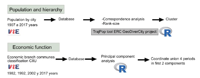
The methodology used for this article was structured in four steps (fig. 1).
In the first step, based on the Spanish for National Institute of Statistics (Instituto Nacional de Estadísticas [INE], 1982, 1992, 1999, 2002, 2012, 2017, 2018) census data and historical information, a population database of the Maule Region by cities from the years 1907 to 2017 was elaborated. In this work, a city was considered according to the definition of the INE (2019), that is to say, the units whose urban population in 2017 was greater than 5000 inhabitants. Important to state that, due to the Chilean political-administrative configuration, the cities employed for this work are also considered a commune, using this category as a synonym of city. The coordinates of each city with its latitude and longitude (obtained from Google Earth) were added to the indicated database.
Once this database has been prepared, a second step was to carry out a Correspondence Analysis (CA) of the population growth rates and in the third step a clustering process was applied to the database, using the “Trajpop2 platform” following the proposal of Pumain et al. (2018), which allows this process to be carried out automatically, in addition to summarise the population evolution with a Rank-Size graph. This allowed a comparative understanding of the growth rates in the evolution of the population in the different populated centers based on figures.
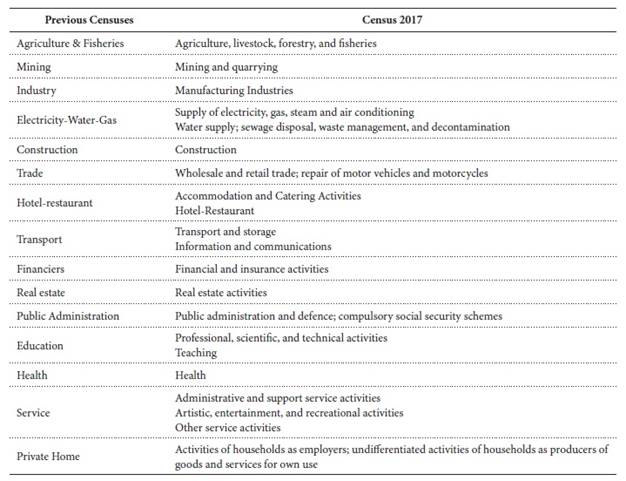
Finally, a Principal Component Analysis (PCA) was carried out as the fourth step, which allows us to observe the functional trajectory of employment in the region’s cities (Paulus, 2004). For this, a data matrix was made which considered 15 branches of employment in different economic branches for four different time contexts (1982, 1992, 2002, and 2017). The International Standard Industrial Classification of all economic activities (ISIC) was followed (Appendix 1). Data was extracted from the different population censuses, highlighting that its availability is only at the community level. The whole process was carried out in R environment.
III. Results and discussion
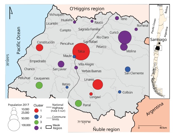
After applying the indicated methods, we expose the different results supported by different figures (figs. 2 and 3).

Fig. 3 Characteristics of the generated clusters: (A) Cluster factor map; (B) Relative weight by cluster; (C) Relative mean weight by cluster; (D) Population mean by cluster. Colour figure available online.
The first analysis was to observe the resulting population evolution clusters. This allowed to group cities that have shown similar rates of population growth between 1907 and 2017. The proposed analysis generated four clusters.
The description of the clusters is presented below. Cluster 1 contains the cities of Talca, Linares, Longaví, and Constitución. Except for Longaví, all correspond to large cities in the regional context, which show a slowdown in their growth dynamics. As for Longaví, it is a small city oriented to low-profit agriculture, close to Linares, which has suffered a demographic stagnation in the last two decades.
Cluster 2 contains the cities of San Clemente, Colbún, Maule, and Retiro. Correspond to small cities, which have had an important increase (for their size) for more than half a century. These areas are close and well connected to larger cities thanks to road infrastructure (with Talca in the case of the first three, and with Linares in the case of the latter).
Cluster 3 includes Parral and Cauquenes. These are cities that, despite having had certain economic importance during the 19th century, show long-term backwardness (from the 1930s onwards; Santana, 2006). These urban centers have developed in the period with a population between 10 and 30 thousand inhabitants (fig. 3D). In other words, in the case of the Cluster 3, the lag is rather structural and can be associated with the crisis of traditional agriculture, which was incubated during that period and deepened in the following decades, during the period of industrialization by substitution of imports (Santana, 2006; Rojas, 2016).
Finally, cluster 4 has the largest number of cities: Curicó, Molina, Romeral, Villa Alegre, San Javier, Teno, Rauco, and Hualañé. This cluster almost entirely belongs to the northern sector of the region, being composed of a wide rank of cities; from cities with close to ten thousand inhabitants to Curicó, the provincial capital, which has around 130 000 inhabitants. An interesting point is that seen from the long term, the nucleus of this dynamic zone (Curicó) has only managed to revert a pattern of clear stagnation that had been in place since the end of the 19th century (Rojas et al., 2015). In other words, the recent success of the northern zone of the region should be traced back to the 1980s.
Another interesting aspect of cities belonging to clusters 2 and 4 corresponds to the dynamics presented by cities like Maule, San Javier, or Yerbas Buenas as satellite cities to Talca or gravitating around the axis of Route 5, the main highway that crosses the region and the country in a north-south way. There is evidence of “success” in the absorption of some small cities located around large urban spaces, a product of real estate dynamics associated with land availability, both for social housing (State policy) or without subsidies (real estate market dynamics for medium sectors).
One way to complement the analysis is by changing the demographic hierarchy of their cities using figure 4 (Rank-Size).
In this figure, it can be seen that historically the first city in the hierarchy of the system of cities has been Talca and in general, the system has behaved in a way that maintains the position of the three most important cities in the region. In other words, the hierarchy has been maintained. However, the same graph shows how the tendency of the regional system has been towards the convergence of Curicó with Talca. This is expressed in how the slope in 1907 between the first city (Talca) and the second (Curicó) tends to smooth out over time, showing the greater dynamism of the latter, in terms of population. At the same time, comparing Curicó with Linares (the third city in the hierarchy in all the periods analyzed), a divergence between both can be seen, due to the greater growth of the first, especially in the last four decades.
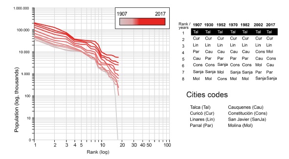
Fig. 4 Rank-Size distribution of cities in the Maule Region. Colour figure available online. Source: own elaboration from Trajpop platform and based on INE (1992, 1999, 2017)
The first is that the fourth city in the urban hierarchy has regularly tended to distance itself from the first three. This is evident when observing a considerable increase in the slope between the 3rd and 4th city in the rank and where Cauquenes, who held that position in various periods, cedes it to Constitución and by 2017 to Molina, a city only 22 kilometers from Curicó. This means that Cauquenes has diminished its demographic importance in the regional system, even losing more than one position in the hierarchy, a rare phenomenon.
A second dynamic corresponds to what happened in the cities located between Cauquenes and the tenth position in the hierarchy. We see that gradually the distribution of the population has become more homogeneous among these cities, that is to say, they have tended to converge in population, being observed to the year 2017 in a practically straight line, which is interesting to note in terms of the own dynamics that such territories have experienced.
Finally, as a third dynamic, small cities are also gaining speed in growth, despite having less population in gross terms, they are being more dynamic. This is evident between the tenth and twentieth cities in the urban hierarchy.
As we have seen up to this point, the urban system of Maule is presenting different dynamics. On the one hand, several of its cities are experiencing a process of convergence, while others have tended to a process of divergence. The interesting thing about this case is that they do not necessarily respond to a pattern of population concentration, from smaller to larger areas, but rather a mixed picture is presented. This makes it necessary to analyze the economic changes that would explain these mixed dynamics.
To this end, we will analyze the second emerging property, that is, the economic specialization of the different communes in the region, based on the generated employment. In that way, we can observe the productive “vocation” that the territories are having, based on the PCA of their functional trajectories in the 1982-2017 period.
The first thing we need to look at is the overall performance of the PCA in terms of data behavior in the first two components. Such analysis is shown in figure 5, which expresses the variance as a function of components and the correlation obtained between each of the variables and the respective components.
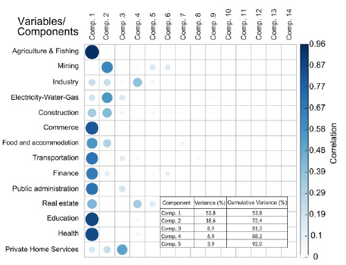
Fig. 5 Correlations between economic sectors and PCA components (1982-2017). Colour figure available online. Source: own elaboration based on INE (1992, 1999, 2017)
There is a cumulative variance of about 72% between the 1st and 2nd components, which is quite significant (fig. 5). The highest correlation in component 1 corresponds to the activity of agriculture and fishing, which is on the negative x-axis and will allow us to interpret the data obtained. Subsequently, other variables linked to the tertiary sector can be seen, such as commerce, health, education, transport, finance, real estate, and to a lesser extent, activities such as accommodation and food and public administration. These activities are on the positive axis of component 1 (i.e., x-axis), therefore showing a high correlation between them. In contrast, in component 2, activities such as mining, electricity-water-gas, and construction are found on the positive (y) axis. On the other hand, the negative axis shows activities such as private households, industry, health, among others.
Figure 6 shows the functional trajectories of the communes between 1982 and 2017 in the first two components.
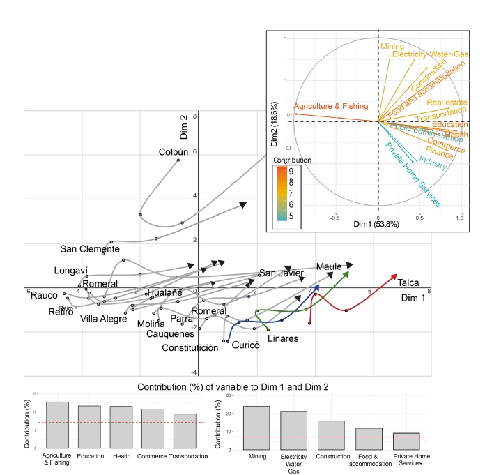
Fig. 6 Functional trajectory of the cities of the Maule Region (1982-2017). Colour figure available online.
In this figure, there are two observations that we can extract. The first is that there is indeed a functional co-evolution of employment in the cities of the Maule Region. The second conclusion, which is in line with what has been experienced in other countries, is that as they grow in population, the communes tend towards more diversified employment, that is, they are less specialized (Bida & Rozenblat, 2020). If the economic profile is observed, from a beginning in the communes (except the three biggest) they have been linked in a predominant way to agricultural activities (some with the fishing sector, those located near the coast), and from that place, they begin to move towards the services sector. This is shown when observing a movement from the negative x-axis, towards the positive one, and in turn towards a positive y-axis. Therefore, in general terms, the number of jobs associated with agriculture and fishing has fallen in the region, beyond the bias of what is presented here, where the figures do not incorporate seasonal employment. This statement, however, should not lead to the interpretation that agriculture has entered into decline and therefore absorbs less employment. In fact, the agricultural sector is still very relevant to the region. A more detailed analysis should focus rather on the changes in the agricultural sector over the last four decades, which have been very marked. These changes can be summarized as a shift from traditional agriculture (in which cereals predominated) to export agriculture (in which fruit, industrial crops, and vines domains) and, therefore, there is a higher level of technification, beyond seasonal labor.
Such processes can be explained by the context of economic liberalization policies generated in the 1970s and 1980s, implemented by opening up to international markets and capital, which sought to use the country’s resources at a high level of efficiency (De Mattos, 1995). In this sense, there was a liberalization of imports, domestic finance, the development of foreign investment, and in turn, export promotion (Turmo & Moslares, 2007), linked to a growing technification of agricultural processes, before (Rojas, 2016; Santana, 2006) and especially after the opening of trade, which allowed an increase in production, in small and medium units, thanks to the arrival of investors from other productive areas and later by transnational companies, especially in the packaging and marketing phase, such as Unifrutti, Dole, Del Monte, among others. These changes have oriented production towards the international market. According to statistics of the Oficina de Estudios y Políticas Agrarias (ODEPA), regional fruit production is mainly destined for export (70.5%), far behind agribusiness (16.5%) and the domestic market (12.8%). The main export destinations for fresh fruit from the Maule Region in 2020 were China (11.7%), the United States (8.9%), Brazil (8.4%), and the Netherlands (6.3%). In 2019, i.e., before the effects of the pandemic on the markets, they were China (14.4%), the United States (11.5%), Taiwan (6.5%), and the Netherlands (5.6%) (Oficina de Estudios y Políticas Agrarias [ODEPA], 2021).
In such a context of transformations, one of the most relevant cases corresponds to the commune of Curicó. Its economy, linked to agricultural resources, has been deeply transformed from traditional agriculture to one with an agro-industrial fruit orientation, which has generated productive chains that favor the tertiarization of its economy. Thus, the current processes of occupation of the regional space are potentially determined by the mutations that have been generated, mainly in the rural landscape during the last years (Pino, 2006).
In fact, when analyzing the performance of the fruit sector at the provincial level (considering the main commune and its surroundings), we see that there have been relevant differences within the region. The distribution of that activity would be a key factor in the economic performance of the territories, due to the absorption of numerous labor (although seasonal and not well remunerated) and the productive chains that it generates (backward and forward), for example, with the installation of refrigerators, the market of fertilizers, agricultural machinery, transport, etc.
At the level of provincial surface destined to fruit-culture, data of the two recent Fruit Census (Centro de Información de Recursos Naturales [CIREN], 2016; Oficina de Estudios y Políticas Agrarias/Centro de Información de Recursos Naturales [ODEPA-CIREN], 2019) were collected (table I).
Thus, the northern territory of the Maule Region, the province of Curicó, accounts for almost half of the regional fruit growing area (42.5%), while the central and southern territories, the provinces of Talca represent 28.5%, Linares 27.5%, and the southwestern part of the region, the province of Cauquenes, represent just 1.5% (and declining). Regardless of the greater concentration of fruit-growing area in the Province of Curicó, it is interesting to note that in recent years (between 2016 and 2019) this expansion has also occurred strongly in the central and southern area of the region, which shows great dynamism maintained by the fruit-growing sector, and an incipient convergence between the provinces of Linares and Talca with that of Curicó.
At the regional level, the area devoted to fruit growing is mainly concentrated in properties between 50 and 499.9 hectares (60.3%) and between 5 and 49.9 hectares (22.3%). The trend of the last decade has been the gradual concentration of the area in larger units, to the detriment of small and even medium-sized producers.
As we pointed out, this has an important impact on the distribution of the 132 760 jobs estimated to be generated by the sector, of which 107 140 correspond to direct labor in the productive units, plus some 25 620 as infrastructure and agro-industrial labor. At least in the period 2013-2016, the absorption of labor increased by 14.6%, which speaks of a sector that is still growing (ODEPA-CIREN, 2019). Within the productive chains of the sector, at a regional level, we have a census of 202 packings, 83 agro-industries, 1053 cold and pre-cold chambers, in addition to 12 fumigation chambers (ODEPA-CIREN, 2019).
At the provincial level, between temporary and permanent jobs, Curicó absorbed 46% of the direct labor force, Talca 18%, Linares 33%, and Cauquenes 3%. At the communal level, the greatest impact of this demand for employment is in the communes of Curicó (11.7%), Teno (10.8%), Longaví (8.6), and Romeral (8.3%). Concerning the employment generated by infrastructure and agro-industry, the divergence in the absorption of labor is even more accentuated: Curicó (63%), Linares (28.5%), Talca (7.7%), and Cauquenes (0.2%), which shows that the productive chain has been more dynamic in the territory of Curicó and the nearby municipalities: Romeral (25.2%), Curicó (10.4%), Teno (10.2%), and Molina (8.8%) (ODEPA-CIREN, 2019).
On the other hand, the commune of Talca has deepened its specialization towards the tertiarization of general services and commerce, becoming the most outstanding commune in such areas of the regional space and in line with what is expected from its role as a regional capital. In this sense, since the beginning of the period in analysis (1982) to date (2017), it presented a greater diversification of the sources of employment towards tertiary sectors, being the most relevant in such direction.
Other interesting cases are the commune of Maule or San Javier, whose trajectories towards the area of commerce and services are accelerated. The cases of Linares, Cauquenes, and Constitución, are quite similar, they were already in a transition at the beginning of the analysis (close to the y-axis) and begin to transit constantly to the x-axis positive (same and positive close to 0), however such transitions goes to simplified jobs in the service area, far from the advanced services in terms of innovation in the areas of computer science or medicine as occurs in other countries with advanced economies (Bretagnolle et al., 2018).
IV. Conclusions
The study of the system of cities in the Maule Region gives us an account of a series of relevant processes. In the first place, far from reinforcing the urban hierarchy, it has presented changes. In effect, there is a gradual convergence between the primary city (Talca) and the next in the hierarchy (Curicó). The fact is not less, considering the enormous centralism of the Chilean political-administrative design, which is replicated on a regional scale. In the second place, the city of Molina, close to Curicó, emerges as the fourth city in the hierarchy, displacing Constitución and even more strikingly, a provincial capital like Cauquenes. In other words, unlike most regions in Chile, Maule has tended to be polycentric.
In the cases studied, a process of economic tertiarisation has been observed, the main change of which is the shift from the predominance of agricultural employment to employment in services. Although this is not new in growing economies, it would seem to be a paradox, since the driving force behind Curicó’s greater dynamism is precisely the boom in fruit growing for export. The returns on financial capital itself, such as the demand for goods and services associated with the activity (linkages) would explain this situation. There has been a certain economic divergence within the Maule Region (between northern and southern Maule), related, among other factors, to the different types of existing agriculture (fruit and agro-industrial dynamism in the north, more traditional agriculture in the south).
Acknowledgements
This work was supported by the Agencia Nacional de Investigación y Desarrollo de Chile, Fondecyt Iniciación, under Grant 11150087.
Authors contributions
Francisco Maturana: Conceptualization; Methodology; Software; Validation; Formal analysis; Investigation; Resources; Data curation; Writing - original draft preparation; Writing - review and editing; Visualization; Supervision; Project administration; Funding acquisition. Andrés Rojas-Bottner: Conceptualization; Methodology; Software; Validation; Formal analysis; Investigation; Resources; Data curation; Writing - original draft preparation; Writing - review and editing; Visualization; Supervision; Project administration; Funding acquisition. Victor Cobs-Muñoz: Conceptualization; Methodology; Software; Validation; Formal analysis; Investigation; Resources; Data curation; Writing - original draft preparation; Writing - review and editing; Visualization; Supervision; Project administration; Funding acquisition. Sebastián Tolosa: Conceptualization; Methodology; Software; Validation; Formal analysis; Investigation; Resources; Data curation; Writing - original draft preparation; Writing - review and editing; Visualization; Supervision; Project administration; Funding acquisition.


