


 Inglês (pdf)
 Artigo em XML
 Referências do artigo
 Enviar este artigo por email
 Citado por SciELO
  Similares em
SciELO
Similares em
SciELO 
 Permalink
1. Introduction
Geographical Indications identify wines originating from a defined geographical area when a certain quality, reputation or other characteristic can be essentially attributed to that geographical origin. The recognition of Geographical Indications (GI) of Brazilian wines opened a new chapter in national viticulture, valuing traditional products from certain territories, enabling the protection of the producing region and guaranteeing the consumer differentiated wines, meeting the specificities of production of each GI. Natural and cultural aspects can influence the typicality of wines and characterize a Terroir, and landscape studies related to viticulture are traditional in many European countries (Fanet, 2004).
The Rio Grande do Sul State generated more than 54% of the grape production (t) and 55% of the national cultivated area (ha) in 2022 (IBGE, 2023). Grape production has been growing since the 1990s (more than 40%), reaching more than 40,000 hectares of planted area in 2015 (Mello & Machado, 2017). Viticulture is mainly concentrated in the wine regions of “Serra Gaúcha”, “Campanha” and “Serra do Sudeste”, but viticulture is present in 91% of the municipalities, characterizing a wine-growing cultural identity (Falcade, 2016).
In the municipality of “Encruzilhada do Sul”, according to Mello and Machado (2017), more than 400 hectares of Vitis vinifera were registered, with the following cultivars: Chardonnay (123 ha) and Pinot Noir (98 ha), Cabernet Sauvign on (38 ha), Merlot (30 ha), Burgundy (23 ha) and Marselan (15 ha). Malbec, Gewurztraminer, Riesling Itálico, Touriga Nacional, Moscato Canelli, Teroldego, Prosecco and Marzemina cultivars were planted on 10 to 5 hectares. Ancelotta, Arinarnoa, Viognier, Tannat, Moscato from Alexandria, Moscato Giallo, Barbera, Tempranillo, Moscato Hamburg, Alicante Bouschet, BRS Violeta and Nebbiolo occurred on 5 to 1 hectare. Other cultivars with less than one hectare represent less than 1% of the area.
The objective of this study was to investigate attributes of the relief for the vineyard (altitude, slope and exposure), integrating data with land use and environmental mapping by geoprocessing techniques, to support studies of wine terroir and wine management. In this study, terroir refers only to the natural characteristics of its physical environment, aiming at environmental aspects, which, accompanied by cultural factors and local knowledge, would determine the typicality of wines from vineyards established or under implementation in the wine region "Serra do Sudeste ".
In this study, the cartographic base was raised on a regional scale, containing mainly the hydrographic network and water bodies, as well as the road network. The relief analysis used ALOS images, generating altimetry, slope and sun exposure, both for favorable aspects to viticulture and to determine areas of environmental protection, such as high slopes. The land use survey was obtained by digitally classifying Sentinel 2 images, linked to vineyard data from the Rio Grande do Sul wine register. The geoprocesses mainly aim to establish permanent preservation areas (PPA) along rivers and lakes, in addition to being crossed with land use data, to see the environmental situation of these areas established in the Brazilian Forest Code (Brazil, 2012).
The result was areas of recommendation, excluded from the PPA and zones that are difficult to manage for viticulture, encouraging good agricultural practices and respecting the Sustainable Development Goals (SDGs). All data was obtained free of charge, as well as the GIS program, and can be applied to any user who wishes to carry out a similar study in an area of interest. The maps and data will be available after the publication of this article in Embrapa's geographic database, GeoInfo (https://www.embrapa.br/busca-de-projetos/-/projeto/209099/geoinfo--infraestrutura-de- data -spatial-da-embrapa), with free access.
2. Literature review
The landscape is generally used as an identity image with spatial and territorial references, such as geographical indications and designations of origin (Falcetti, 1994; Falcade, 2010,2013; Maby, 2002). According to Carey et al. (2002), a natural terroir unit is a surface characterized by relatively homogeneous patterns of topography, climate, geology and soils and has agronomic potential that is reflected in the characteristics of its products, being a set of natural environmental factors that are difficult to modify by the producer. Vaudour (2002) describes a method of identifying terroirs using satellite images in soil-landscape models; applying digital image processing that integrates thematic maps, generating potential terroir units. These identity elements in the landscape of each region reinforce its image and can be used in the marketing of wines and sparkling wines, contributing to regional economic growth and differential (Flores et al., 2010; Flores et al., 2012).
Aspects of the physical environment of a vineyard can affect airflow patterns, slope, thermal properties and water availability influencing vine growth (Wilson, 1998). In hot, dry summer climates, soil may be the most important factor, but in cooler climates, slope and exposure are very important factors (Huggett, 2006). The most adopted definition of terroir is that of the OIV (International Organization of Vine and Wine), which relates collective knowledge with natural factors and human aspects to the characteristics of the product originating in a given space, being: “Terroir includes specific soil characteristics, topography, climate, landscape and biodiversity” (OIV, 2010).
In Brazil, the main wine regions present diversity in land use, environment, relief, soils, among other aspects. The “Serra Gaúcha” wine region encompasses consolidated geographical indications, which contain diversity related to volcanic events of the Mesozoic era, in which lava flows generated very characteristic relief levels (Hoff et al., 2014). In the wine region of the “Campanha Gaúcha”, there is a diversity of relief, geology and soils (Hoff et al. 2018), as well as in the wine region “Vale do Submédio Rio São Francisco”. Studies investigated since 2000s, the association between viticulture and geomorphology, in the Serra Gaúcha wine region, characterizing the geographical indications “Pinto Bandeira”, “Monte Belo” and “Farroupilha” (Hoff et al., 2014). However, there is viticulture implemented in all the geomorphological provinces of Rio Grande do Sul (IBGE, 2003).
The wine region of “Campanha Gaúcha” was recognized in 2020 as a geographical indication for wines and sparkling wines (Revista Rural, 2020), and thus, other regions seek recognition, with geomorphological and landscape studies. In this region, studies have shown the diversity of distribution of vineyards in different geomorphological units, related to the wine landscape (Hoff et al., 2018), as well as employing geotechnology (Hoff, 2021).
In the “Serra do Sudeste” wine region, studies have shown its importance, suggesting areas of geographical indication, where there are vineyards of important wineries since the 1970s. In this region, studies used geotechnology to obtain criteria for wine terroirs, relief, geology and geomorphology in a GIS environment (Hoff et al., 2009; Hoff et al., 2017). The landscape of the “Encruzilhada do Sul” region results from successive erosions in very old lands of the “Sul-Rio-Grandense” Shield, and the relief is inserted in the morphostructural domain in Complex Styles, including the Geomorphological Region “Planalto Sul-Rio-Grandense” (IBGE, 2003).
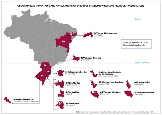
In Brazil, the Geographical Indication (GI) is an industrial property instrument that aims to distinguish the geographical origin of a given product or service. As provided in art. 176 of the Industrial Property Law (LPI), are considered Geographical Indication (GI) or Appellation of Origin (AO), according defined in arts. 177 and 178 of the LPI (Brazil, 1996). Figure 1 indicates the wine regions of Brazil.
3. Material and method
This study used the digital image elevation model from Advanced Land Observing Satellite (ALOS), with a spatial resolution of 12.5 m, considered with sufficient precision for a regional approach, through comparative studies by Silva Júnior et al. (2022) and Guth et al. (2021). Relief aspects such as hypsometry, slope and sun exposure were investigated, being reclassified into suitable intervals for viticulture, as observed by Hoff et al. (2009). Data was resampled to 10 m resolution, to be integrated with land use, obtained by Sentinel 2 image with 10 m of spatial resolution. Relief aspects were previously reclassified into ranges suitable for viticulture with SRTM data given by Hoff et al. (2009).
Areas above an elevation of 300 meters were selected, where most of the region's wine-growing vineyards are located. Based on studies that observed, for every 100 meters of altitude, there would be a drop of 0.6 °C in the average air temperature, being the most important climatic effect for viticulture (Mandelli & Miele, 2003).
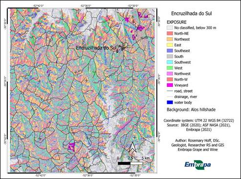
Thus, in this area above the 300-meter elevation, the hypsometry was classified in 50-meter intervals. The slope was classified in the intervals: 0-3% - flat; 3-8% - gentle; 8-30% - moderate; 30-45% - moderate steep; greater than 45% - steeply. Exposure was classified in the ranges: 0 - 22.5° and 337.5 - 360° (North); 22.5 - 67.5° (Northeast); 67.5 - 112.5° (East); 112.5 - 157.5° (Southeast); 157.5 - 202.5° (South); 202.5 - 247.5° (southwest); 247.5 - 292.5° (West); 292.5 - 337.5° (northwest).
Among the intervals mentioned, the exposure of the soils oriented to the north, northeast and northwest were considered as more favorable to viticulture, being discarded the terrains oriented to the South, Southeast and Southwest due to possible undesirable shading for viticulture. As for the declivity, the flat, gentle and moderate terrain classes were considered more favorable to the implantation, due to the ease of agricultural management. The moderate relief, even with slopes close to 30%, was considered advisable, as it would provide better soil drainage, recommended for viticulture. For flat land, precautions must be taken to avoid water accumulation, which can favor root diseases in Winter and disease of fruit in Summer, among other problems. Lands with a slope greater than 30% were discarded due to difficult mechanized management.
Permanent preservation areas were defined in two categories: 1) drainage margins with 30 meters from the basic map (IBGE, 2003) and 2) slopes greater than 45%, from the slope generated by the DEM of the ALOS image (12.5 m spatial resolution).
Land use was generated by classifying the Sentinel 2 image with 10 spatial resolution. Polygons of the vineyards were added, coming in part from the Rio Grande do Sul wine register (Mello & Machado, 2017) and another part obtained by interpreting images in Google Earth, with support from fieldwork.
Hypsometry, slope, and sun exposure data were integrated by geoprocessing, and the final product was crossed with land use and PPA maps.
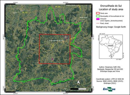
The studied area is located into the geographic coordinates: -30°28'24.62 S and -30°45'40.71 S (latitude); -52°27'31.96“ W and -52°45'34.67” W (longitude), througout 92,295.00 hectares. The location of the “Encruzilhada do Sul” area, “Serra do Sudeste” wine region is shown in Figure 2.
4. Results
4.1. Relief analysis
The altimetry of the viticultural area of the Municipality of "Encruzilhada do Sul" varies from 104 m to 511 m above sea level. The amount of areas below and above 300 m is shown in Table 1.
Table 1: Area above and below 300 meters of elevation in the “Encruzilhada do Sul”, Brazil
| Elevation (m) | Area (hectares) | Percent (%) |
| 104 - 300 m | 11,390.17 | 12.34 |
| 300 - 511 m | 80,904.83 | 87.65 |
| Total | 92,295.00 | 100 |
Source: Elaborated by the authors.
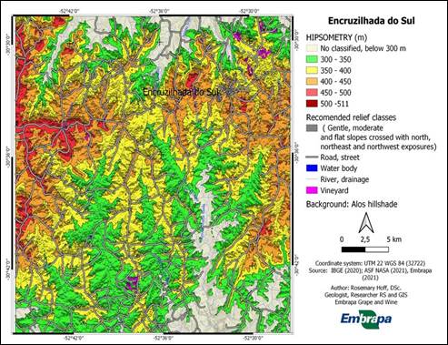
In the area above 300 meters, the reclassification of altimetry from 50 to 50 meters showed predominant intervals between 300 - 350 and 350 - 400 meters, totaling 70.12%. However, there are large areas between 400 - 450 meters (24.30%) and a very small but important area between 450 - 500 meters (5.56%).
The slope varies between 0 - 81.73 %, from flat to steepy slopes (Table 3). The range 8 - 20% predominates; moderate, with half the area (50.94%). The range of 3 - 8%, gentle, makes up 32.83% of the studied area. The slopes correspond to the predominant dissection patterns of terrain, where the flat slope classes represent less than 10% of the area. The moderate steep slope (20-45%) and Steep (45-75%) have areas of 7.63%. The steeply slopes (more than 75%) are approximately 1 hectare.
The reclassified solar exposure in the eight quadrants was balanced between 10 and 13% of the area above 300 m. The largest areas belonged to the East (13.41%), Southeast (13.40%) and West (13.09%) classes, with the North being the smallest (10%). However, the areas facing the North, Northwest and Northeast add up to more than 34.71%, showing that, in terms of exposure, the "Encruzilhada do Sul" area can be considered excellent for winegrowing. The summary of relief aspects, above 300 meters, around the main viticultural area of "Encruzilhada do Sul" is presented in Table 2.
Table 2: Relief evaluate showing reclassified area above 300 meters of altitude, at "Encruzilhada do Sul", "Serra do Sudeste" wine region, Brazil
| Class | Area (hectares) | Percent (%) | |
|---|---|---|---|
| Elevation (m) | |||
| 300 - 350 | 26,472.67 | 32.72 | |
| 350 - 400 | 30,259.69 | 37.40 | |
| 400 - 450 | 19,662.70 | 24.30 | |
| 450 - 500 | 4,498.06 | 5.56 | |
| 500 - 511 | 10.06 | 0.01 | |
| Total | 80,904.83 | 100 | |
| Slope (%) | |||
| 0 - 3 (flat) | 6,959.44 | 8.60 | |
| 3 - 8 (gentle) | 26,558.94 | 32.83 | |
| 8 - 20 (moderate) | 41,217.33 | 50.94 | |
| 20 - 45 (moderate steep) | 6,049.22 | 7.48 | |
| 45 - 75 (Steep) | 118.72 | 0.15 | |
| More than 75 (steepy) | 1.19 | 0.001 | |
| Total | 80,904.83 | 100 | |
| Exposure (North azimuth degree) | |||
| 0°-22.5°/337°-360° (N) | 8,189.69 | 10.12 | |
| 22.5° - 67.5° (NE) | 9,795.69 | 12.11 | |
| 67.5° - 112.5° (E) | 10,850.62 | 13.41 | |
| 112.5° - 157.5° (SE) | 10,838.19 | 13.40 | |
| 157.5° - 202.5° (S) | 10,436.53 | 12.90 | |
| 202.5° - 247.5° (SW) | 10,104.09 | 12.49 | |
| 247.5° - 292.5° (W) | 10,590.391 | 13.09 | |
| 292.5° - 337.5° (NW) | 10,099.62 | 12.48 | |
| Total | 80,904.83 | 100 | |
Source: Elaborated by the authors.
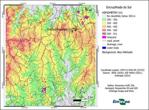
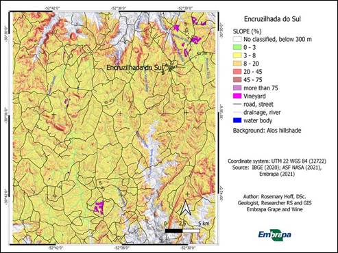
The Figures 3, 4 and 5 show hypsometry, as well as slope and sun exposure, respectively, in the region above 300 meters, around the main wine-growing area of "Encruzilhada do Sul".
Source: Elaborated by the authors
Figure 3 Hypsometry above 300 meters, suitable for vineyard management. "Encruzilhada do Sul", "Serra do Sudeste" wine region, Brazil
Source: Elaborated by the authors
Figure 4 Classified slope, "Encruzilhada do Sul", "Serra do Sudeste" wine region, Brazil
Source: Elaborated by the authors
Figure 5 Classified exposure, "Encruzilhada do Sul", "Serra do Sudeste" wine region, Brazil
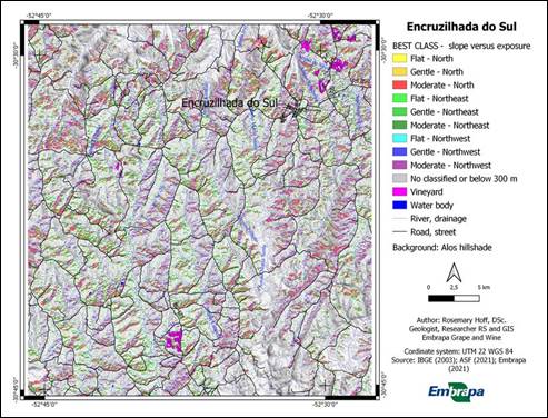
The intersection of slope and sun exposure classes in the area generated 51 new classes. However, were considered only nine crossing classes (25972.73 hectares), by combining the classes shown in Table 3.
Table 3: Gentle, moderate and flat slope classes crossing with north, northeast and northwest exposures in the total area and area above 300 meters altitude. "Encruzilhada do Sul", "Serra do Sudeste" wine region, Brazil.
| Crossing class | Area above 300 m | ||
|---|---|---|---|
| Area (hectares) | Percent (%) | ||
| Flat - North | 147.06 | 0.57 | |
| Gentle - North | 2,912.14 | 11.21 | |
| Moderate - North | 4,483.92 | 17.26 | |
| Flat - Northeast | 1,061.05 | 4.08 | |
| Gentle - Northeast | 3,038.03 | 11.70 | |
| Moderate - Northeast | 5,013.09 | 19.30 | |
| Flat - Northwest | 1,070.05 | 4.12 | |
| Gentle - Northwest | 3,085.98 | 11.88 | |
| Moderate - Northwest | 5,161.41 | 19.87 | |
| Total | 25,972.73 | 100 | |
Source: Elaborated by the authors.
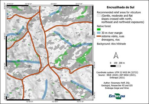
The sum of the recommended areas, in relation to the relief aspects, presented a percentage of 32.10 of the area between 300 and 511 m of altitude (Table 4). The Figure 6 shows the geographic distribution of areas recommended for viticulture according to the intersection of hypsometry, slope and sun exposure in "Encruzilhada do Sul".
Table 4: Favorable clustered areas above 300 meters altitude. "Encruzilhada do Sul", "Serra do Sudeste" wine region, Brazil
| Clustered areas above 300 m | Area (hectares) | Percent (%) |
| Favorable area | 25,972.73 | 32.10 |
| No classified, below 300 m | 54,932.1 | 67.90 |
| Total area | 80,904.83 | 100 |
Source: Elaborated by the authors.
Source: Elaborated by the authors
Figure 6 Best classified exposure crossing by slope above 300 m elevation. "Encruzilhada do Sul", "Serra do Sudeste" wine region, Brazil
Some wine regions consider altitude important for viticulture, to classify terroirs or micro climatic zoning (Miele & Mandelli, 2003). The favorable reliefs obtained in this study were also analyzed by hypsometric interval (Table 5) and the spatial result is shown in Figure 7. The terrains located at range 350 - 400 meters predominated (36.92), as well as 300 - 350 (32.83 %) and 400 - 450 meters (24.50 %). Recommended areas for viticulture by hypsometric range are shown in Figure 6.
Table 5: Recommended area by relief aspect to viticulture, above 300 meters, per hypsometry range. "Encruzilhada do Sul", "Serra do Sudeste" wine region, Brazil
| Hypsometry (m) | Recommended areas (Gentle, moderate and flat slopes crossed with north, northeast and northwest exposures) | ||
|---|---|---|---|
| Area (hectares) | Percentage (%) | ||
| 300-350 | 8,526.70 | 32.83 | |
| 350-400 | 9,589.91 | 36.92 | |
| 400-450 | 6,362.94 | 24.50 | |
| 450-500 | 1,488.91 | 5.73 | |
| 500-510 | 4.28 | 0.02 | |
| Total | 25,972.73 | 100 | |
Source: Elaborated by the authors.
Source: Elaborated by the authors
Figure 7 Geographical distribution of recommended area by relief aspect to viticulture, above 300 meters, per hypsometry range. "Encruzilhada do Sul", "Serra do Sudeste" wine region, Brazil
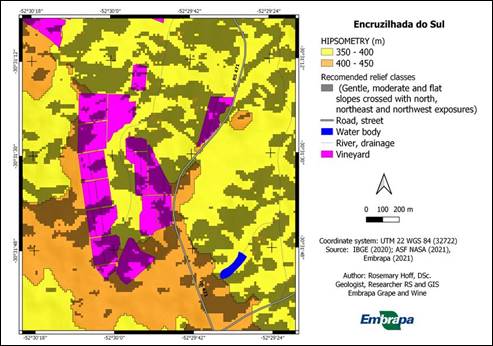
This information can be useful to growers when they look more closely at the vineyards compared to areas recommended by altimetry, slope and sun exposure. Out-of-context areas can be monitored more frequently and/or separate grapes from areas recommended for making distinctive wines. The Figure 8 shows an example of vineyards and their best areas according to zoning studied.
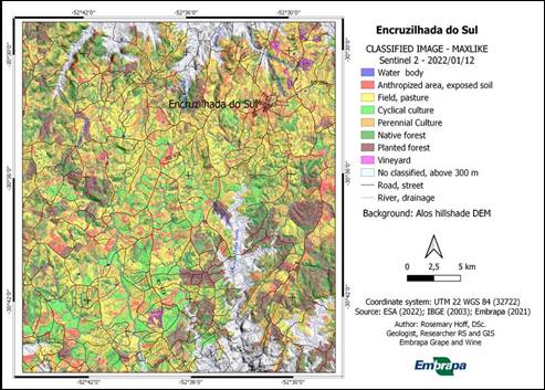
4.2 Land use and land cover
Generally, in the Wine Geographical Indications in Brazil, aspects of land use and PPA are considered, according to the Brazilian Forest Code. Torri et al. (2008) and Hoff et al. (2016) analyzed permanent preservation areas in 2005 and 2015 for the Geographical Indication “Vale dos Vinhedos”, Rio Grande do Sul, Brazil.
The land use was obtained from the Sentinel image classification, scene from January 2, 2022, of the area above 300 meters of altitude, as shown in Figure 9. The quantitative areas of the classes are presented in Table 6. In this period, perennial crops predominate in the studied area (28 %), however, the native forest is the second class in area (22 %). The pasture area is still very extensive, due to the traditional use in the region, being gradually replaced over time by planted forests of eucalyptus and pine. There is an increase in the substitution of pastures for cyclical crops, such as soybeans and corn.
The vineyards occupy 367 hectares (less than 1%), being an area smaller than that indicated in the Rio Grande do Sul Wine Registry, due to the area studied with Vitis vinifera being restricted to more than 300 m of altitude.
Source: Elaborated by the authors
Figure 9 Land use and land cover above 300 m elevation, at "Encruzilhada do Sul", "Serra do Sudeste" wine region, Brazil. Elaborated by the authors
Table 6: Land use in the area above 300 meters in the "Encruzilhada do Sul", "Serra do Sudeste" wine region, Brazil.
| Land use class | Area (hectares) | Percent (%) |
| Perennial culture | 21,708.28 | 26.84 |
| Native forest | 18,039.02 | 22.31 |
| Field, pasture | 16,016.70 | 19.81 |
| Planted forest | 9,520.84 | 11.77 |
| Anthropized area, exposed soil | 7,958.77 | 9.84 |
| Cyclic culture | 7,148.45 | 8.84 |
| Vineyard | 366.75 | 0.45 |
| Water body | 107.83 | 0.13 |
| Total | 80,866.64 | 100 |
Source: Elaborated by the authors.
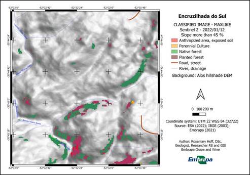
The permanent preservation areas were obtained by crossing masks around from drainage lines (30 meters), occupying 6447.93 hectares of the studied area (7.97%). The PPAs with slopes above 45% occupy 201.17 hectares of the area (0.25%). The distribution of these two types of PPA is shown in Figure 10.
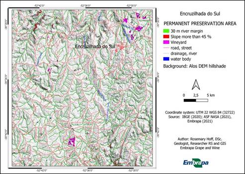
4.3. Land use versus permanent preservation areas - PPA
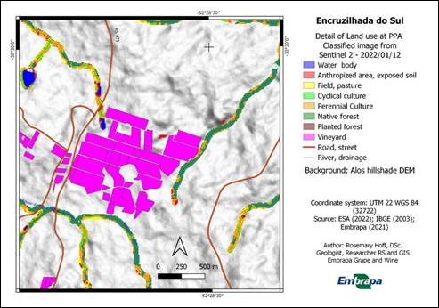
The PPA areas were reclassified according to land use obtained from the Sentinel 2 image of January 12, 2022 (Table 7). The predominant class, at 30 m river and drainage margin, was native forest followed by perennial culture. Vineyards practically do not affect the areas of this type of PPA, except at 2 ha (0.03%). The class with the largest area in the PPAs with a slope greater than 45% is also the native forest, followed by the anthropized area/exposed soil and the planted forest, with no vineyards in this type of PPA. Figures 11 and 12 present details of the two types of PPA areas and uses within them.
Table 7: Land use at PPA in the "Encruzilhada do Sul", "Serra do Sudeste" wine region, Brazil
| Land use class | Area (hectares) | Percent (%) |
| 30 m river margin | ||
| Native forest | 3,328.85 | 51.63 |
| Perennial culture | 1,498.95 | 23.25 |
| Planted forest | 528.24 | 8.19 |
| Field, pasture | 423.06 | 6.56 |
| Cyclic culture | 396.43 | 6.15 |
| Anthropized area, exposed soil | 247.70 | 3.84 |
| Water body | 22.64 | 0.35 |
| Vineyard | 2.06 | 0.03 |
| Total | 6,447.93 | 100 |
| Slope more than 45 % | ||
| Native forest | 73.28 | 36.42 |
| Anthropized area, exposed soil | 40.03 | 19.90 |
| Planted forest | 38.46 | 19.12 |
| Perennial culture | 24.14 | 12.00 |
| Cyclic culture | 18.73 | 9.31 |
| Field, pasture | 6.53 | 3.25 |
| Total | 201.17 | 100 |
Source: Elaborated by the authors.
Source: Elaborated by the authors
Figure 11 Detail of Permanent preservation areas, according to 30 m river margin, at "Encruzilhada do Sul", "Serra do Sudeste" wine region, Brazil
4.4. Recommended area versus native forest and permanent preservation areas - PPA
In this data integration, were considered at the intersection with areas of native forest and PPA of river and drainage margin, since PPA of areas with slopes greater than 45% are not included in the recommended areas for viticulture.
Thus, as shown in Table 8, the areas recommended for viticulture occupy 1705.12 hectares within the PPA and overlap the native forests in 4845.58 hectares. These areas must not be used either for viticulture or for any other purpose in the studied area, with the exception of the recovery of native forest. The final area recommended for viticulture has a dimension of 19422.03 hectares, where areas with native forest (scene of the Sentinel 2 image of 2022-01-12) were excluded, as well as permanent preservation areas 30 meters from the rivers and drainages. Figure 13 shows an example, in detail, of areas recommended by the relief superimposed on PPA and native forest.
Table 8: Favorable clustered areas above 300 meters altitude into PPA. "Encruzilhada do Sul", "Serra do Sudeste" wine region, Brazil.
| Clustered areas above 300 m, best slope versus exposures | Area (hectares) | Percent (%) |
| 30 m River margin | 1,705.12 | 6.57 |
| Slope more than 45 % | 0.00 | 0.00 |
| Native forest | 4,845.58 | 18.66 |
| No PPA or native forest | 19,422.03 | 74.77 |
| Total | 25,972.73 | 100 |
Source: Elaborated by the authors.
4.5. Vineyard environment
Currently, the vineyards that occur in the studied area occupy 366.58 hectares, only 0.46% of its totality. Most vineyards are located on areas with altitudes ranging from 300-350 m (65%) and 350-400 m (31%), on a gentle (50%) to moderate (40%) slope and predominant southwest exposure (20%). However, there are terrains with North, Northeast and Northwest exposures, summing 36%. Unfavorable exposures such as the South, Southwest and Southeast sum 41%. However, the farms that plant vineyards are extensive enough in the region and can choose more favorable areas to expand their vineyards and monitor old vineyards that present less favorable conditions of relief. This result showed that 36% of the vineyards in the studied area are located in areas of relief favorable to viticulture, mainly slopes combined with sun exposure (Table 9).
Table 9: Summary of the occurrence of vineyards on studied classes of relief, land cover and PPA units. "Encruzilhada do Sul", "Serra do Sudeste" wine region, Brazil. Elaborated by the authors.
| Class | Area (hectares) | Percent (%) | |
|---|---|---|---|
| Hypsometry | |||
| 300-350 m | 239.04 | 65.21 | |
| 350-400 m | 113.90 | 31.07 | |
| 400-450 m | 13.64 | 3.72 | |
| Total | 366.58 | 100 | |
| Slope | |||
| 3-8 % - gentle | 187.00 | 51.01 | |
| 8-30 % - moderate | 143.70 | 39.20 | |
| 0-3 % - flat | 35.80 | 9.77 | |
| 30-45 % - moderate steep | 0.08 | 0.02 | |
| Total | 366.58 | 100 | |
| Exposition | |||
| Southwest (202.5° - 247.5°) | 73.49 | 20.05 | |
| South (157.5° - 202.5°) | 46.89 | 12.79 | |
| West (247.5° - 292.5°) | 47.66 | 13.00 | |
| North (0° - 22.5° and 337.5° - 360°) | 47.25 | 12.88 | |
| Northeast (22.5° - 67.5°) | 45.03 | 12.28 | |
| Northwest (292.5° - 360°) | 42.62 | 11.62 | |
| East (67.5° - 112.5°) | 33.26 | 9.07 | |
| Southeast (112.5°- 157.5°) | 30.38 | 8.29 | |
| Total | 366.58 | 100 | |
| Land cover units | |||
| Vineyard | 366.58 | 100 | |
| Other uses | 0.00 | 0.00 | |
| Total | 366.58 | 100 | |
| PPA units | |||
| 30 m River Margin | 2.06 | 0.56 | |
| More than 45 % | 0.00 | 0.00 | |
| No occurrence PPA | 364.52 | 99.44 | |
| Total | 366.58 | 100 | |
Source: Elaborated by the authors.
In relation to native forests and permanent preservation areas, this study showed that vineyards have low influence on these lands. In the case of a 30-meter riverbank, there was little overlap (2 hectares), which may be due to the pixelization of the classified image (10 m), which sometimes added areas within the buffer of PPA.
All data was exported in shape and tiff format, as well as thematic maps are available on the Embrapa geographic database website - GeoInfo (http://geoinfo.cnpuv.embrapa.br/).
5. Conclusion
The area above 300 m constitutes 84% of the total area of study, however, after reclassification, a terrain more suitable for viticulture can be selected in 32.10% of this area (25,972.73 hectares). The reduction to area above 300 meters of altitude provided better slopes and sun exposure for viticulture. In this selected zone, in flat areas, often moisture can be retained longer and potentiate plant diseases, as drainage can be slow in both Summer and Winter.
In addition, due to the study of land use (native forest), as well as permanent preservation areas (river/drainage margin), an area of 19,422.03 hectares was recommended, with 74.77% of the area favorable for the implementation of vineyards, from the point of view of the relief.
The terrains with moderate slope are smaller in the area above 300 meters, considering that the geomorphology is conditioned by the terrains in dissection, and most of the larger slopes are at lower altitudes, below 300 meters.
Coincidentally, the areas indicated for viticulture predominate both in the area above 300 meters of altitude (Tables 5 and 8). Generally, areas suitable for viticulture coincide with areas recommended as soils suitable for viticulture pointed for Flores et al. (2009). In general, the results coincided with the characteristics of the terrains of most vineyards located in the wine-growing area.
The municipality of "Encruzilhada do Sul" contained 424 hectares planted with vineyards until 2015, according to Mello and Machado (2017), confirming the trend of land use for viticulture currently implemented. In the study area, vineyards above 300 m sum 366.58 hectares. The vineyards are predominantly close to the urban area, but there is a possibility of expansion in the recommended area, by more than 19,000.00 hectares. The producers can choose locations indicated in this study, with altitude, slope and excellent exposure for viticulture, preserving the environment.
Since vineyards do not occupy PPA areas, it is recommended that winegrowers reclaim PPA areas adjacent to vineyards on their farms, which could add value to the viticultural landscape and, consequently, to the final product.
This study may contribute to the characterization of a part of the "Serra do Sudeste" wine region ("Encruzilhada do Sul"), encouraging or even guiding studies of new geographical indications and terroirs in the whole of this wine region. However, it is recommended for the monitoring of environmental aspects of land use to be done periodically through satellite images and digital classification. Producer associations, in order to guarantee the maintenance of forests in coexistence with viticulture, can organize this.
The availability of data in GEOINFO in formats agreed worldwide can be visualized in the system, as well as downloaded and inserted in a free GIS software, by producers and their associations.

