




 Inglês (pdf)
 Artigo em XML
 Referências do artigo

 Tradução automática
 Enviar este artigo por email
 Citado por SciELO
 Similares em
SciELO

 Permalink


Highlights
High-resolution mapping reveals dynamic vegetation changes in Serra da Estrela.
Imagery classification effectively distinguishes eleven vegetation classes.
Significant expansion of shrublands, linked to declining grazing.
Notable forest reduction due to fires and land-use shifts over 25 years.
Study aids conservation planning in Serra da Estrela's protected and sensitive areas.
1. Introduction
1.1 Overview
1.1.1 Background and context
Mountain ecosystems are globally recognised for their ecological significance, biodiversity richness, and sensitivity to environmental changes (Grabherr et al., 2011; Körner, 2004). These high-altitude environments often host unique plant communities, shaped by steep ecological gradients, climatic variability, and long-term geomorphological processes (Viviroli et al., 2007). Their vegetation patterns are not only important indicators of ecological health but also reflect the ongoing interactions between natural factors and human land use (Beniston, 2003). The patterns observed here mirror broader trends in high-altitude environments worldwide, where climatic gradients, isolation, and traditional land-use practices have shaped rich but vulnerable plant communities.
Vegetation mapping in mountain areas has become increasingly relevant in the context of climate change and land-use transformations, which are causing notable shifts in species composition, distribution, and structure (Pauli et al., 2012; Tasser et al., 2005). Accurate and up-to-date vegetation cartography is essential for understanding these dynamics and for guiding conservation and sustainable land management policies in protected mountain landscapes.
1.1.2 Remote Sensing in Vegetation Mapping
The need to improve the quality and detail of cartography has led to the application of Remote sensing (RS) methods that revolutionised the study of vegetation, particularly in morphologically complex and inaccessible areas such as mountainous regions. The use of satellite imagery provides access to a wide range of multispectral data, offering extensive temporal and spatial coverage at a relatively low cost, especially with open-source options available (Monteiro-Henriques et al., 2016; Xie et al., 2008). The high-resolution and repeatability of RS data make it a practical solution for studying the dynamic and diverse environments of mountain ecosystems. Furthermore, RS technologies allow for the identification of species and communities, detection of changes in vegetation distribution patterns, providing insights into the dynamics of these communities and the effects of external factors such as climate change and human activities (Wang et al., 2015). However, applying RS in mountainous regions presents specific challenges due to the complexity of the landscape, including steep topography, rapid and significant environmental changes, and atmospheric and topographic conditions that can affect data accuracy (Gartzia et al., 2013). Despite these challenges, RS remains an invaluable tool for environmental monitoring and natural resource management in these difficult-to-access areas. In this specific work, a multispectral image from August 2020, provided by a satellite (Worldview 2), with 2m resolution, was mainly used to classify the vegetation communities on the plateau. Due to the flowering period of a specific community, a Sentinel-2 image was also used to differentiate it from other vegetation.
1.1.3 Objectives of the Current Study
Despite the existing studies, a high-resolution mapping of the vegetation in this area has not been undertaken until now. The work presented here complements previous studies by providing a detailed cartographic analysis of the most significant vegetation communities on the plateau of Serra da Estrela. In addition, this study also aims to assess the vegetation dynamics by comparing the newly produced map with previous photographic records, such as ortho-photomaps from 1995. This analysis will provide insights into the temporal changes and shifts in vegetation cover, allowing for a better understanding of how these ecosystems have evolved over time. This cartographic work is fundamental scientific knowledge that supports better land management practices to protect biodiversity and mitigate potential disturbances to the habitats in this area.
1.2 Study area
1.2.1 Geographical Context
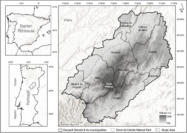
The Serra da Estrela (40º20’N, 7º35’W) is part of the Central Mountain Range. It belongs to the Hesperic Massif, forming the westernmost and highest part of a mountain alignment extending SW-NE, composed of elongated plateaus-oriented WSW-ENE (fig.1). This region stretches from Guarda to Serra da Lousã, covering approximately 115km with an average width of 25km (Daveau, 1969). It is internationally recognized for its geological significance and is part of the Unesco Geoparks Network (Estrela Geopark). Additionally, it hosts the Serra da Estrela Natural Park, the largest protected area in Portugal, which shelters endemic vegetation and wildlife refuges of national importance (Decreto-Lei n. º 557/76). The specific study area within this context (fig.1 at the bottom left) focuses on the Upper Plateau, from Vale do Rossim to Torre, including the headwaters of the Zêzere, Alforfa, Loriga, Caniça, and Alva rivers. This area is of significant scientific, environmental, landscape, and cultural interest and is included in the Natura 2000 network, Ramsar Convention, and the biogenetic reserve of the Serra da Estrela Natural Park (Castro et al., 2019).
1.2.2 Geological and Topographic Features
Serra da Estrela is the highest mountain range in mainland Portugal, with the highest elevation in the southwest, reaching 1993m at the Planalto da Torre (Vieira, 2004). The mountain is bounded by fault scarps to the east and west, and river incisions shape its current topography following the uplift of the mountain. The landscape is also heavily influenced by the nature of its rocks, mainly granite and schist, as well as by the glacial activity during the Last Glacial Maximum in the Upper Pleistocene (Ferreira et al., 2001; Ferreira & Vieira, 1999; Vieira, 2004). The higher plateau, above 1600m, is divided by the Zêzere and Alforfa valleys into two main sectors: the Western and Eastern Plateaus. The study area is within the Western Plateau, characterized by distinct relief subunits, such as Planalto das Penhas Douradas (1500-1550m), Planalto do Curral do Martins (1650-1760m), and Planalto da Torre (above 1800m), with the Curral do Martins and Torre plateaus being referred to as the Superior Plateau (Vieira, 2004).
1.2.3 Climate Characteristics
The climate of Serra da Estrela is distinctive and varies significantly with altitude, topography, and exposure to prevailing winds. According to the Köppen classification the the southeast side of Serra da Estela Mountain is characterized by a hot-summer Mediterranean (Csa) type, whereas the northwest side features a mild-summer Mediterranean (Csb) climate (Santos et al., 2024). The mountain's altitude, topography, and orientation play significant roles in modifying the local climates, with increased altitude leading to lower annual average temperatures, estimated to decrease by 0.6ºC per 100m of elevation (Mora, 2006). The study area, specifically the Upper Plateau, has an estimated average annual temperature of 4-6ºC, with the coldest month being January and the warmest month being July. Precipitation is marked by abundant rainfall in winter and dry summers. The wet season is from October to May, with a mean annual precipitation of ca. 2500mm in the summit, while the plateaus show more than 2000mm. The western side of the mountain presents a larger number of days with rainfall, but a slightly lower total amount than the eastern part, which in turn shows a smaller number of days with rain (Daveau et al., 1977). The western slopes receive more precipitation due to orographic lifting, contrasting windward and leeward areas (Vieira & Mora, 1998). Frequent fogs on the western slope are responsible for hidden precipitation that increases water availability. Snowfall is a significant feature in the higher altitudes, though it varies greatly in frequency and duration. The presence of snow plays a crucial role in protecting vegetation from extreme cold and wind, contributing to soil and plant temperature regulation, and supporting plant growth during the melting period (Pauli et al., 2012; Wang et al., 2015).
1.2.4 High-Altitude Vegetation in Serra da Estrela
The high-altitude plateau of Serra da Estrela, precisely above 1600m, presents a distinct type of vegetation compared to lower altitudes. This area is predominantly characterized by shrublands and high-altitude grasslands typical of mountain environments (Jansen, 2002). The vegetation here is shaped by extreme climatic conditions, including thermal extremes, snow accumulation for longer periods, and wind, alongside historical and ongoing anthropogenic influences such as pastoral activities, intentional burning, and more recently, tourism (Jansen, 2011).
The current vegetation in Serra da Estrela is also the result of significant climatic changes over time, with historical evidence indicating the presence of ten distinct climatic and edaphic-forest types, many of which have been altered or destroyed (van der Knaap & van Leeuwen, 1994). Fire, both natural and anthropogenic, has played a crucial role in shaping the vegetation, often acting as both a destructive force and a process of pasture renewal, though its increasing frequency in recent decades poses a significant threat to local ecosystems (Barrico et al., 2019; Connor et al., 2012). Tourism has further impacted the landscape by increasing ecosystem pressures through recreational activities (Fidalgo, 1994; Jansen, 2011; Soncco, 2020). The unique geographical and climatic conditions of Serra da Estrela have made its flora a scientific interest since the 18th century, with significant botanical expeditions contributing to our understanding of this isolated mountain's vegetation (Machado et al., 2007).
The region hosts over 900 taxa from more than 90 botanical families, including several endemic species and a variety of floristic elements such as Mediterranean, Temperate European, Boreo-Alpine, and Arctic-Alpine types, all of which have been significantly altered by human activity (Jansen, 2002; Meireles & Pinto-Gomes, 2012). The richness of its flora is attributed to factors like climate variability, geological diversity, proximity to Africa and the Atlantic, and historical influences, particularly the Quaternary glaciations (Jansen, 2002; 2011).
1.2.5 Historical and Botanical Significance of the Region
The unique characteristics of this vegetation have long attracted the interest of the scientific community, resulting in a significant amount of research that highlights the diversity and specificity of the flora in this region (Henriques, 1883; Meireles, 2010; Meireles, et al., 2008; Pinto da Silva & Teles, 1980). In 1994, J.P. Fidalgo mapped the vegetation above 1600 meters in Serra da Estrela, using a grid system to document the distribution of species prioritized for conservation, providing a detailed inventory of species (Fidalgo, 1994). The Institute for Nature Conservation and Forests (ICNF) produced later a different vegetation map, focusing on natural habitats of community interest, as listed in the Habitats Directive. This mapping predominantly identified heath and shrub habitats in temperate zones and flora of ecological interest, although it differed from Fidalgo's classification (ICNF, 2019).
1.2.6 Vegetation Types and Habitats
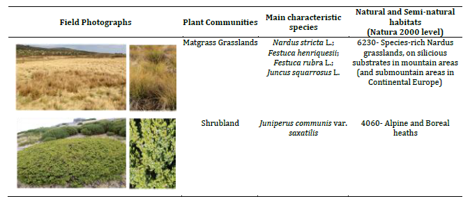
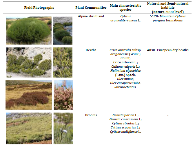
The vegetation of Serra da Estrela is diverse, with significant altitudinal variation, influencing the distribution of plant communities. The area of interest, the Upper Plateau, is predominantly characterized by high-altitude shrublands and grasslands, which dominate above 1600m. These habitats are of considerable biodiversity importance and are included in conservation initiatives such as Natura 2000 (table I), Ramsar, and the biogenetic reserve of the Serra da Estrela Natural Park. Shrublands in the upper areas are dominated by species such as Juniperus communis var saxatilis Pall., Cytisus oromediterraneus L. and Echinospartum ibericum Rivas Mart., Sánchez Mata & Sancho. Between 1400 and 1700m of altitude, dominant species include other leguminous shrubs such as Cytisys stratus L., C. scoparius L., G. florida L. or G. cinerascens L., and the heaths Erica arborea L. or E. australis L. (Jansen, 2002). Other smaller shrubs such as Calluna vulgaris L. or Halimimum lasianthum subsp alyssoides (Lam.) Greuter. can be found associated with the main shrubs. Grasslands, maintained by grazing, are mostly dominated by Nardus stricta L., although they can harbor a significant number of endemic and rare species such as Festuca henriquesii Hack, Campanula herminii Hoffmans & Link, Armeria sampaioi (Bernis) Nieto Fel., Gentiana lutea L. or Fritillaria nervosa subsp nervosa Willd.
Table I - Main classified communities (in terms of occupied area), respective examples in the field and Natura 2000 habitat (cont.).
Source: Authors’ elaboration
2. Methodology
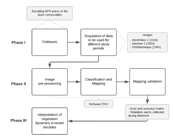
The methodology of this investigation was structured in three main phases (fig. 2). Phase I involved a literature review, selection and analysis of the study area, fieldwork, and the selection an acquisition of images for vegetation classification and comparison. Phase II focused on image pre-processing, followed by the classification of vegetation communities and creation of the final maps. Finally, in Phase III (section IV Discussion), vegetation dynamics over the past decades were interpreted by comparing the 1995 ortho-photomap with the 2020 satellite imagery, allowing for the identification of significant changes in the vegetation communities over time.
2.1 Phase I
2.1.1 Fieldwork
Fieldwork was fundamental to the classification process, involving three campaigns for data collection and validation (fig. 3). The initial campaign, conducted in September 2021, focused on collecting ground truth points using differential GPS (D-GPS) to establish training areas for image classification.
Despite challenges like limited network coverage in higher elevation areas, supplementary methods such as hand-held GPS devices and photographic documentation facilitated the accurate identification of vegetation types. Subsequent field campaigns in April and May 2022 were dedicated to collect validation points to ensure the accuracy of the vegetation maps.
2.1.2 Data Collection
For the vegetation classification, two satellite images and one ortophotomap where used. For the 2020 cartography of the plateau, high-resolution satellite imagery was used from WorldView-2 (WV2).
WV2 offers high spatial resolution with 2.0 meters in eight multispectral bands, including standard RGB and NIR bands, as well as additional bands like coastal blue, yellow, red-edge, and a second near-infrared (NIR2) band (table II), which are particularly useful for vegetation analysis (Hung & Treitz, 2020; Rapinel et al., 2014). The WV2 image used in this study was captured on August 1, 2020, under optimal conditions-clear skies, minimal shadow, and no cloud cover. Due to the inability of this image to distinguish all the desired vegetation classes found in the field, and solve spectral overlapping between them, an S2 image of the flowering season was used.
To understand the recent changes in vegetation distribution on the Serra da Estrela Plateau a comparison from 1995 and 2020 was made. This comparison was essential to understand the dynamics of vegetation communities over 25 years. This study utilized orthoimages from 1995, obtained from the Directorate General for Territory. The image, with a scale of 1:25 000 and a resolution of 1 meter, lacked sufficient spectral information for automated classification (table II).
2.2 Phase II
2.1.1 Image pre-processing
The WV2 image pre-processing included radiometric and atmospheric corrections to enhance the quality of the WV2 images. Radiometric calibration adjusted the images from radiance to reflectance and was performed using the Radiometric Calibration tool in the ENVI software (Harris Geospatial, 2023). The atmospheric correction, was applied using the FLAASH tool in the same software, using the image acquisition information (Latitude, Longitude, date and time of the flight and sensor type), was also defined the atmospheric model to Mid-Latitude Summer (MLS), a rural aerosol model and 40km for the initial visibility, considering a clear sky at the acquisition time (Harris Geospatial, 2023). This improved the accuracy by accounting for atmospheric conditions at the time
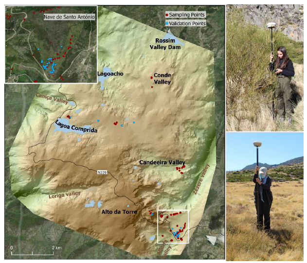
Fig. 3 - Survey of the sampling points of the plant communities and validation, using GPS, throughout the study area and in detail in the Nave de Santo António. Photo of the fieldwork. Source: Inês Mendes (2021)
Table III - Sensors used and their characteristics (images used, camera, bands with central wavelength and resolution, represented at the same scale).
| Satellites | Orthophotomap | ||
| WorldView-2 | Sentinel-2 | ||
| Camera | WorldView-110 | Sentinel (L2A image) | |
| Acquisition date | 01/08/2020 | 30/05/2020 | 1995 |
| Bands | Coastal (400-450 nm) Blue (450-510 nm) Green (510-580 nm) Yellow (585-625 nm) Red (630-690 nm) Red Edge (705-745 nm) Near-Infrared 1 (770-895 nm) Near-Infrared 2 (860-1,040 nm) | Coastal Aerosol (443 nm) Blue (490 nm) Green (560 nm) Red (665 nm) Red Edge 1 (705 nm) Red Edge 2 (740 nm) Red Edge 3 (783 nm) Near-Infrared (NIR) (842 nm) Narrow Near-Infrared (865 nm) Water Vapor (945 nm) SWIR-Cirrus (1,375 nm) Short-Wave Infrared 1 (SWIR 1) (1,610 nm) Short-Wave Infrared 2 (SWIR 2) (2,190 nm) | False color |
| Resolution | Panchromatic ∼ 0.5m Multispectral ∼ 2.0m | 10m | 1m |
| Source | ESA | Copernicus EO browser | https://www.dgterritorio.gov.pt/ |
Source: Authors’ elaboration
of image capture (Adam et al., 2017; Brunn et al., 2003). There was no need to perform orthorectification since the image is already extracted with this correction (Rapinel, et al. 2014). For the Sentinel-2 L2A the pre-processing process was not necessary, as this image is already fully corrected - including orthorectification, and radiometric, atmospheric, and topographic corrections.
Orthophotomaps were downloaded as individual images, requiring georeferencing, orthorectification, colour correction and harmonization to be suitable for subsequent classification. The entire process was conducted in a GIS environment using ArcGIS Pro software (Esri, 2023). The first step involved georeferencing each individual image using the spline transformation method, based on known coordinate points within the image. To produce the final mosaic, the images were combined using the Mosaic Dataset tool with default parameters. To enhance the visual quality of the final mosaic-by homogenising colour, brightness, and contrast- histogram manipulation and colour correction was performed using the Dodging method for colour balance and the first-order method for colour surface type. These steps were critical to ensure the extraction of high-quality data, following the guidelines of Brunn et al. (2003).
2.2.2 Vegetation Classification Process
For the WV2 and S2 image classification process, a supervised approach (Rapinel et al., 2014) was employed, utilizing Regions of Interest (ROIs) based on field data and photointerpretation, using all the bands available to better distinguish between classes (Hung et al. 2020). To determine the number of classes needed, a preliminary unsupervised classification was conducted, providing an estimate of the optimal number of vegetation classes for detailed mapping. This step facilitated the pixel based supervised classification, which was considered the most suitable method for this type of vegetation analysis. Several classifiers were tested, including parametric methods like Maximum Likelihood, which achieved the best overall accuracy. The final optimal number of classes was achieved after various attempts and validation on the field (see section 2.3).
The ortophotomap was processed through manual photointerpretation and classification of the final mosaic. Vegetation classes were harmonized considering the main vegetation units, resulting in five broad categories: Forest, Shrubs, Matgrass grasslands, Spare Grasslands, and "Other Classes".
2.2.3 Validation
Validation was carried out using two approaches: statistical and in-situ. No validation was performed for the orthophotomap, as the classification was manual and to the year 1995.
Statistical accuracy assessment was conducted through the generation of an error matrix. To produce the error matrix, new ROIs were created for each class used in the final classification, based on field samples. Using the post-processing tool in ENVI software, the matrix was generated (table III) with the Confusion Matrix Using Ground Truth ROIs tool.
In-situ validation was carried out in fieldwork and became crucial to understand and correct significant spectral confusion that persisted among vegetation classes in the WV2 classification.
After the validation process the initial classification was refined, supported on knowledge of the study area. Certain Shrubland classes, such as Cytisus, Genista and Heaths were merged due to overlapping spectral characteristics (originating the ‘Brooms and Heaths’ class), especially outside the flowering season, and their dense distribution in mixed vegetation communities. These adjustments helped reduce classification errors, improving the overall map accuracy to 94% (table IV).
To address the necessity of merging classes, the Sentinel-2 image classification was integrated, using all the available bands and following the same methodological procedure as the WV2. This last was particularly useful for distinguishing certain species like Heaths (belonging to the class ‘Brooms and Heaths' in the WV2 classification) during their flowering period, illustrating the importance of selecting temporally appropriate imagery (Anderson et al., 1993; Cingolani, 2004). Despite challenges, including the need to merge similar classes and adjust for spectral variations within the same species, the methodology enabled a detailed and accurate mapping of vegetation communities on the plateau. The process underscored the critical role of combining field data, advanced satellite imagery, and sophisticated classification techniques in ecological mapping.
Table IV - Validation of the classification carried out for the Plateau (WorldView 2 image).
| Classification classes | Producer Accuracy (%) | User Accuracy (%) |
|---|---|---|
| Evergreen Forest | 78.35 | 60.32 |
| Deciduous Forest | 96.27 | 91.49 |
| Brooms and Heaths | 81.25 | 89.97 |
| - Heaths* | 83.13 | 79.50 |
| Rockroses | 90.91 | 64.52 |
| Heathers | 97.55 | 80.78 |
| Juniper | 84.00 | 61.76 |
| Matgrass grasslands | 88.14 | 97.17 |
| Sparse Matgrass | 83.54 | 42.58 |
| Rushes | 100.0 | 93.33 |
| Ferns | 83.14 | 85.22 |
| Bare soil | 50.50 | 42.86 |
| Bare Rock | 73.17 | 71.31 |
| Water Bodies | 99.43 | 99.99 |
| Shadow | 99.04 | 56.28 |
| Road | 58.88 | 93.93 |
| Built Area | 87.31 | 94.55 |
| Agricultural area | 97.60 | 89.56 |
| Overall Accuracy = 93.7% | ||
| Kappa Coefficient = 0.85 |
*Heaths classified with the Sentinel 2 image. Source: Authors’ elaboration based on WorldView 2 image
3 Results
3.1 Current Characterization of Vegetation Communities
Bare rock accounts for 32% of the area, being the second most represented class which reflects the high-altitude terrain with minimal vegetation cover. Rock outcrops are often covered with lichens and mosses. Other non-vegetation classes include areas of bare soil, where sparse grasses grow among the granite sands, and a minimal presence of built structures, mainly related to tourism activities at the mountain summit and the village of Sabugueiro in the northwest of the classified area. Water bodies on the plateau, such as natural, semi-natural, and artificial lagoons, are mapped. Large flooded areas, like peat bogs, which contain other plant communities, were not included in the mapping.
Our study identified eleven vegetation classes within the mapped area (fig. 4). These classes range from forests at lower altitudes to communities of Juniper, Heather, and matgrass at higher elevations. Forests are located at lower altitudes (1530m for evergreen forests and 1600m for deciduous forests), and a gradual transition to Alpine Shrubland and Grassland communities at higher altitudes.
Shrublands and Alpine Shrublands are divided into five classes: Brooms (Cytisus and Genista spp), Heaths (Erica spp), Heathers (Calluna vulgaris), Rockroses (Halimium lasianthum subsp alyssoides) and Junipers (J. communis var. saxatilis). Brooms and Heaths together represent the largest vegetation type representing 65.9% of the total vegetation cover. Cytisus and Genista species, classified together as Brooms, are widespread across the plateau, occupying most of the vegetated territory, particularly along valleys, slopes, and areas around Vale do Conde.
The heath class was classified separately due to a different image resolution (10m compared to 2m for the rest of the map), and its distribution often overlaps with other classes on the ground. Heaths are primarily found between 1600 and 1700m, while other shrub species (also belonging to the heathland community) like rockroses and heather are associated with moist areas of the plateau, such as Nave de Santo António, Vale da Candeeira, and Vale do Conde. Junipers represents the upper altitudinal range of vegetation distribution and is strongly represented at altitudes between 1700 and 1900m, particularly along the road connecting Torre to Lagoa Comprida and on the area below Torre.
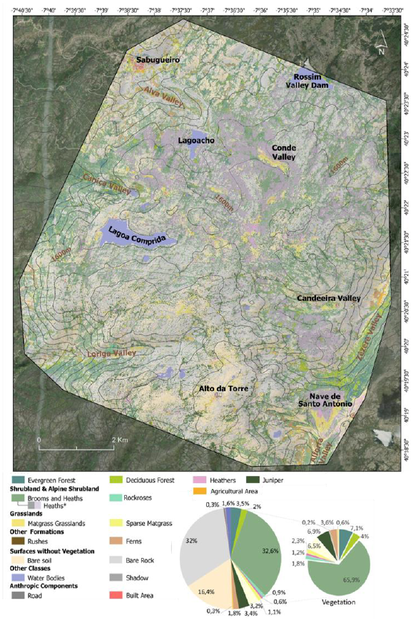
Fig. 4 - Distribution of the communities under study for the Serra da Estrela Plateau and their mapped percentage. *Different resolution (S2 derived). Source: Authors’ elaboration based on WorldView 2
Grasslands, either densely covered by matgrass or sparsely covered by other grasses such as Agrostis truncatula Parl, are mainly found in depressed areas, mostly above 1600m, and in surrounding areas like Nave de Santo António, Lagoa Comprida, and Vale do Conde. These communities are often spatially associated with other species such as Rockroses, Heaths, Heath rushes (Juncus squarrosus L.) and sometimes Gorses (Ulex spp). Sparse grasslands, which occur throughout the upper plateau, are interspersed with bare soil.
Rushes and Ferns were mapped due to their distinct spectral signatures and significant presence in the area. Rushes are less visible at this scale, mainly in grasslands or areas with high soil moisture. Ferns, which are more prominent, originate from two distinct communities: those in recently burned areas dominated by Pteridium aquilinum and those in moist, sheltered locations along valley floors dominated by Polystichum setiferum. Their main expression is between 1300 and 1600m, with sporadic occurrences above 1600m.
Echinospartum ibericum, an endemic spiny legume shrub locally known as “Caldoneira” that appears associated with junipers and high-altitude brooms was not classified due to its residual distribution and the resolution used in the classified image.
3.2 Comparison of Vegetation Dynamics (1995-2020)
Comparing the orthophotomap obtained for 1995 and the high-resolution 2020 map (fig. 5), we observed a notable decrease in forested areas, particularly in the northern region around the village of Sabugueiro and valleys, which had dense tree cover in 1995 but by 2020, these zones exhibited a visible increase in scrubland and sparse scrubland, suggesting a shift in vegetation cover.
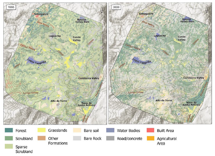
Fig. 5 - Mapping of the plateau communities for 1995 and 2020. Source: Authors’ elaboration based on WorldView 2
Similarly, Fern-dominated areas, classified under "Other Communities," have diminished in size and are now mixed with shrubs and patches of forest. Grasslands, previously widespread across the central and southern sectors-particularly near Alto da Torre and Lagoa Comprida - showed a marked decrease in extent. Agricultural land has also been reduced, especially near Sabugueiro, highlighting a shift in land use. The shrublands showed a mixed pattern, with some areas like the Conde Valley exhibiting reduced shrub density, while other regions, such as near Lagoa Comprida, experienced an increase in shrub density over time. Built-up areas and the road network remained largely unchanged across both maps.
4. Discussion
This work presents a detailed study of the spatial distribution and temporal dynamics of the vegetation in Serra da Estrela upper valleys and plateaus. The mapping of vegetation communities contributes to the delimitation of habitats with relevant natural value, such as those limited by the Natura 2000 Network Sector Plan, supporting decision-making and conservation planning. Also, the vegetation in these extreme environments serves as an indicator of the changes taking place at the level of the ecosystem in which they are located and can be vulnerable to changes and disturbances.
Methodologically, the use of very high-resolution, multispectral satellite imagery - with eight distinctive bands - for the main supervised classification proved to be crucial for the detailed mapping of the plateau, achieving an overall accuracy of 94%. This distinguishes the study from others relying on lower-resolution data or field surveys alone, emphasizing the value of Earth Observation in environmental monitoring.
Nevertheless, the classification faced challenges, particularly in spectral separation of certain species and communities, and the exclusion of some less represented classes due to the 2m pixel resolution. It was impossible to separate Cytisus, Genista and Erica due to their proximity on the ground and spectral similarity. However, despite Cytisus and Genista species being physiognomically similar, they form communities with different characteristics and are separated in the territory, with Cytisus oromediterraneus dominating at higher altitudes.
Among the limitations of this study is the use of an WV2 imagery from a single season, which may reduce the accuracy of classification for species with seasonal variability, and the difficulty in mapping small or fragmented vegetation types that fall below the 2m pixel resolution. Improvements could be achieved with high-resolution imagery from different seasons, enabling more detailed classification and the distinction of geographically significant species. Field-based validation across seasons and more extensive ground-truth datasets could also refine classification accuracy and support long-term ecological monitoring.
Despite those limitations, the analysis provided a comprehensive understanding of vegetation patterns across the study area, revealing clear spatial relationships between different plant communities. These patterns are strongly influenced by altitude, with distinct variations in vegetation distribution that reflect gradients along altitudinal zones.
A noticeable decrease in forest cover, likely linked to recurring forest fires, such as the significant event in 2017, marks one of the key vegetation changes observed over the study period. However, monitoring forest areas is of special interest to detect potential shifts in altitude, particularly in the context of climate change, which could drive forest expansion above 1600m in protected areas (Grabherr et al., 1994; Pauli et al., 2003).
The most significant change was observed in the class Matgrass grasslands, which have substantially declined, with these areas being increasingly overtaken by shrubs. This shift may be linked to the decline in pastoral activities, as grazing and controlled burns has historically maintained these grasslands and limit the shrub expansion. If we analyse the number of livestock by geographic location (Instituto Nacional de Estatística INE, 2022) within the municipalities that the study area is part of (primarily Seia, followed by Manteigas), we can observe a decrease in the number of sheep indicating a reduction on pressure from grazing activities. This reduction has likely contributed to the expansion of shrublands, as grazing is responsible for maintaining Matgrass grasslands by controlling shrub growth (Rudley et al., 2023; Sanz-Elorza et al., 2003). The loss of these practices is now driving to passive ecological succession toward more homogeneous and woody vegetation, with implications in biodiversity, affect soil infiltration and water retention, and increase flammability, potentially amplifying the frequency and intensity of wildfires in the region.
Along with the decline in grazing, climate change may be also promoting shrub encroachment as it has been shown for other mountains. Indeed, our results align with the recorded expansion of C. oromediterraneus and J. communis in the upper belt of the Iberian Central Massif and the Moncayo mountain, where shrub encroachment into grasslands has been noted, influenced by factors such as rising temperatures, changes in land use, and reduced grazing (Gómez-García et al., 2023; Sanz-Elorza et al., 2003).
5. Conclusion
The use of high-resolution satellite imagery and advanced GIS techniques, supported the successful mapping of vegetation of the Serra da Estrela Upper Plateau, providing a detailed representation of the vegetated area. This mapping reveals a diverse and complex vegetation landscape, shaped by natural and anthropogenic factors. This study also reveals alterations in the vegetation over a short period (1995-2020), marked by a reduction in forested and agricultural areas and an increase in shrubland. Factors such as large fires and shifts in land use, particularly the decline in traditional pastoral practices and the reduced use of fire for pasture maintenance, may have also contributed to the spread of shrubland into areas previously dominated by grasslands. These findings are consistent with similar trends observed in other Mediterranean and montane environments, where land abandonment have driven shrub invasion and a reduction in traditional open habitats (Brandt, et al., 2013; Gómez-García et al., 2023; Pauli et al., 2003; Sanz-Elorza et al., 2003).
Overall, this research contributes with valuable insights into the ecological structure and dynamics of this protected area, useful for future land management and conservation strategies aimed at preserving its rich natural heritage. The detailed knowledge of the distribution of the main habitats is the first step towards adopting appropriate management measures, making it possible to preserve the open landscape and this vegetation, which is of scientific and environmental interest.
Acknowledgements
This work was funded by the Programmatic Budget of the Centro de Estudos Geográficos (UIDP/00295/2020). Special thanks are to the Estrela Geopark for the assistance during fieldwork.
Author`s contribution
Inês Ferreira Mendes: Conceptualization, Methodology, Software, Validation, Formal analysis, Investigation, Resources, Data curation, Writing - original draft preparation, Writing - review and editing, Visualization. Carla Mora: Conceptualization, Methodology, Validation, Investigation, Resources, Data curation, Writing - review and editing, Visualization, Supervision, Project administration, Funding acquisition. Susana Rodríguez-Echeverría: Conceptualization, Validation, Writing - review and editing, Supervision.

