INTRODUCTION
Wildfires are key drivers of significant changes in soils and ecosystems (Pausas, 2015) being considered a main disturbance in the Mediterranean basin (Gonçalves and Sousa, 2017). Fires can change greatly the physical characteristics of the soils and, consequently, the dynamics of the water and vegetation, as well as microbioma activities (Hrelja et al., 2020). As a result, the soil can be prone to other degradation processes such as erosion.
Fire severity and duration, and intrinsic soil characteristics contribute to distinct post fire recovery of the soil-plant system and its productivity. Therefore, studying the postfire dynamics of soil physical properties is of major concern for the conservation and productivity of ecosystems.
Various studies have focused on post fire soil changes according to fire severity (Heydari et al., 2017), being the short term post fire dynamics the most studied subject in Mediterranean regions (Ekinci, 2006; Pereira et al., 2015, 2018). However, few studies have been done for the long term assessment (Fonseca, 2017; Francos et al., 2020). Furthermore, studies for cork oak forests are scarce, despite the high economic and ecological value of these ecosystems.
This work aims to evaluate post fire physical soil properties of cork oak forests eight and 16 years after the wildfire, and to understand the natural recovery of the soil-plant system.
MATERIAL AND METHODS
Study area
The study area is located in Serra do Caldeirão, a mountain range in southern of Portugal, which constitutes a natural limit between Algarve and Alentejo regions. The landscape is characterized by vast areas of cork oak forests and shrub cover dominated by Cistaceae species. The climate is Mediterranean classified as Csa in Köppen classification (Köppen, 1936). The soils were developed on schist and greywackes, included in the Mira Formation (Oliveira, 1982), and can be classified as Leptosols and Cambisols (WRB, 2014).
Two very large wildfires occurred in the study area in the past decades. The fire of 2004 burned about 13600 ha and the fire of 2012 burned about 24300 ha. These burned areas correspond to 17% and 30% of the study area, respectively.
A total of 47 plots (with an area of about 441 m2 per plot) were selected at the study area: 12 unburned plots, 25 plots burned in 2004 and 10 plots burned in 2012. Areas without fire occurrence for at least 25 years were considered as unburned. At each plot, three undisturbed soil samples were collected until 5 cm of depth and analyzed for the physical parameters (Table 1).
Table 1 Soil physical analysis done in the present study
| Soil physical parameters | Description of analyses |
|---|---|
| Moisture | Drying 24-48 h |
| Coarse and fine fractions (> and < 2 mm) | Sieving at 2 mm |
| Bulk density | Core ring |
| Porosity | Calculated from bulk density |
One-way ANOVA was used to test significant differences of physical soil properties among unburned, burned in 2004 and burned in 2012 plots. An alternative non parametric Kruskall Wallis test was conducted in case of assumptions violation.
RESULTS AND DISCUSSION
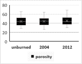
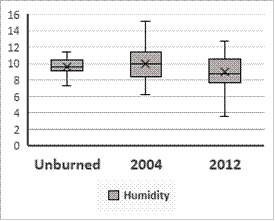
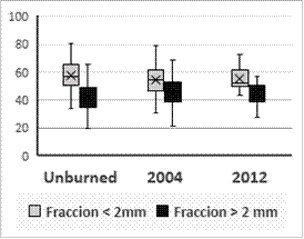
The physical soil properties analysed did not show significant differences among burned and unburned plots, independently of the fire year (Figures 1-3).
Bulk density and porosity are important physical properties, especially in Mediterranean conditions, since they are linked to soils water retention and infiltration capacity. Values of bulk density varied between 0.91 and 1.9, representing a porosity between 27 to 69 % of total volume (Figure 1).


Figure 1 Bulk density (cm3/cm3) and porosity (%) in the superficial layer (0-5 cm of depth) of the soils from cork oak forests (unburned, burned in 2004 and burned in 2012).
Post fire changes of these parameters are dependent on fire severity, organic matter concentration in soil and ashes amount (Hrelja et al., 2020). Bulk density can increase immediately after the fire due to ash incorporation in soil or the degradation of organo-mineral aggregates, and as a result, the soil porosity decreases (Certini, 2005). Nonetheless, strong plant development in the study area, especially pioneer shrub species such as Cistus ladanifer that rapidly colonize burned areas, may have improved the soil structure, which led in the long-term to similar values of bulk density and porosity for both unburned and burned plots (Figure 1). In fact, plant development in burned areas was higher than in unburned ones (data not shown). Moreover, soils from burned plots presented higher organic matter content than from unburned plots, which also increased with years following the fire (11.53, 18.12 and 36.76 g Corganic/kg for unburned, burned in 2004, and burned in 2012, respectively).
The similar values in bulk density and porosity for both burned and unburned plots can also explain the low values of moisture in the soils (Figure 2).

Figure 2 Percentage of moisture in the superficial layer (0-5 cm of depth) of the soils from cork oak forests (unburned, burned in 2004 and burned in 2012).
Although, post fire selective removal of soil fine fraction due to erosion, in present study this is not clear. In fact, soils presented a higher proportion of fine fraction (<2 mm), in relation to coarse fraction, consistently across all burned and unburned plots (Figure 3).
CONCLUSIONS
In this study, soil physical parameters were analysed in order to assess long-term post fire effects and soil resilience. There were no significant differences for all parameters between unburned and burned plots, independently of the fire year, which indicates soil recovery to the pre-fire state. Further analyses are needed in order to better understand recovery processes of cork oak forests soils after fire.


