Serviços Personalizados
Journal
Artigo
Indicadores
-
 Citado por SciELO
 -
 Acessos
Links relacionados
-
 Similares em
SciELO
Compartilhar
CIDADES, Comunidades e Territórios
versão On-line ISSN 2182-3030
CIDADES no.41 Lisboa dez. 2020
https://doi.org/10.15847/cct.20497
ARTIGO ORIGINAL
Where the fields have no name: Urban-rural transitions in the Lisbon Region planning history
«Where the fields have no name»: transições urbanas-rurais na história do planeamento da Região de Lisboa
Teresa Marat-MendesI; João Cunha BorgesII; Sara Silva LopesIII; Mafalda Matos PereiraIV
[I]DINÂMIA’CET-Iscte, Portugal. e-mail: teresa.marat-mendes@iscte-iul.pt
[II]DINÂMIA’CET-Iscte, Portugal. e-mail: jcbsa11@iscte-iul.pt
[III]DINÂMIA’CET-Iscte, Portugal. e-mail: sara_alexandra_lopes@iscte-iul.pt
[IV]DINÂMIA’CET-Iscte, Portugal. e-mail: mmpas1@iscte-iul.pt
ABSTRACT
This paper discusses the existing urban-rural dichotomy in Portuguese urban planning, assuming its importance on food-provision, a basic human need. Our analysis stems from an historical overview at two scales, regional and municipal, within the Lisbon Region. Specifically, we identify key changes between two time-periods: the mid-twentieth century, when design-based planning was established in Portugal for larger settlements, and nowadays, when it covers the totality of the national territory, based on land-use. We review these strategies, assessing what approaches would best encompass a sustainable transition of the food system.
We start with the scheme of regional radial axis by architect Étienne de Gröer in contrast with the 2002 Lisbon Regional Plan. We furthermore expose two urbanization plans from 1940s: that of Vila Franca de Xira (1946) by Miguel Jacobetty and Faria da Costa and that of Palmela (1948) by João António Aguiar. Such plans, highly representative of the planning practices of that era, are then compared with their contemporary counterparts and subsequently with samples of their physical impacts on the ground, based on a morphological analysis of settlements and productive spaces in urban and rural contexts. Finally, we identify key changes for better use of productive soils within the Lisbon Region, considering challenges posed by international and national agendas.
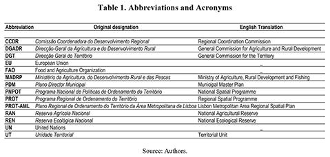
1. Introduction
Urban-rural partition is a touchstone of Portuguese spatial planning and a key to our interpretation of the places we inhabit. Yet, this results from modern space conceptions inherent to capitalist production (Weaver, 1984; Sonnino, 2019). Distinction between city and countryside is older, but premodern cities were tightly linked with rural hinterlands. Modern capitalism turned this into a hierarchical model: the countryside (producer) becomes economically dependent on the city (consumer). More recently, as many Western cities went post-industrial (Hass & Westlund, 2018), both city and countryside depend upon the interests of multinational corporations beyond territorial political control and increasingly free to take facilities and labour wherever they prefer (Weaver, 1984). Additionally, in poor countries, cheap crops exported to rich nations have long represented a significative volume of foreign exchange income (Moorcroft, 1972; Naredo & Valero, 1999). This directly contributed to unequal patterns of exchange between cores and peripheries, both among and within countries (D’Alisa et al., 2015).
The urban-rural polarization is not about separating nature and artifice, but ensuring an unequal chain of production and consumption, spatialized by a planning doctrine that became “an extension of the ideology of multinational capitalism” (Weaver, 1984, 1). Contemporary critiques noticed the associated negative environmental impacts, calling for a more sustainable urbanism. This encompasses reducing and re-using resources, recycling materials and using renewable energies, i.e. a circular metabolism, to which spatial planning can contribute (Rogers, 1997). Socio-metabolism analyses flows, stocks of materials and energy needed for everyday life, and the mutual exchanges between coupled natural and social processes (Ibañez & Katsikis, 2014; Fischer-Kowalski & Weisz, 2016). Urban-rural or production-consumption polarization imprints onto the territory the capitalist linear metabolism. Metabolic circularity demands mixed land-uses, waste reuse, and avoidance of CO2 emissions resulting from transportation. Small-scale grassroots actions like eco-communities, cooperatives, urban agriculture, time-banks and short-supply chains are increasingly acknowledged as alternatives to capitalist development and its unsustainability (D’Alisa et al., 2015).
In the mid-twentieth century, architects started acknowledging the environmental pitfalls of urbanization. But although food-provision was always part of this discussion (Moorcroft, 1972), its relation to architectural and urban design is still underrepresented (Parham, 2015). Sustainable transitions rekindled interest in the degrowth paradigm (Meadows et al., 1972), which critiques economic growth as the chief societal goal, calling for a qualitative (not quantitative) change towards less resource consumption in rich countries, and a reorganization of life beyond capitalism (D’Alisa et al., 2015).
No human settlement can thrive without fundamental access to housing, electricity, clean water, mobility systems, telecommunications, infrastructure and food. However, urbanites grew accustomed to consuming food produced anywhere (Steel, 2008). When we consider spatially the patterns of production, transformation, distribution, commerce, consumption and disposal of food, i.e. the food system (Pothukuchi & Kaufman, 2000; Steel, 2008; Parham, 2015) we inevitably must question how territories are organized, since we often ignore negative externalities of agrifood business and their associated “productivist spatial fix”, separating city and countryside (Sonnino, 2019).
Foodsheds, the region necessary to feed urban populations, have been studied throughout the 20th century and contributed to critically assess problems of transportation and land-use. It also influenced wider debates regarding the re-localization of food-supplies to decrease ‘food-miles’, i.e. the distance covered by foodstuffs from production to consumption (Brinkley, 2013). This is a key spatial challenge of sustainable food system transitions, demanding a reappraisal of regional rural spaces. Attention is also needed to the potentials of urban green spaces, promoting urban agriculture and its ability to cover at least part of families’ food consumption (Viljoen et al, 2005).
This, however, demands innovative policies integrating sustainability in the food sector and acknowledging systemic problems in food-consumption patterns (Reisch et al, 2013). Moreover, austerity capitalism has prompted new forms of poverty including the “alarming spectacle of nutritional poverty, one of the most insidious forms of poverty” (Morgan, 2013,3-4) which we must urgently tackle.
Food system phases have spatial translations, from land-uses to facilities and buildings. Post-World War II market liberalization intensified spatial segregation (Weaver, 1984; Spaargaren et al., 2012; Marat-Mendes, 2020), while before, food-provision was an important factor shaping cities (Steel, 2008; Salvador & Oliveira, 2015; Slater, 2020). This relationship is achieving full-circle, as cities assume a role as food-policy actors, motivated by problems like food price surges, food insecurity, negative ecological impacts and land conflicts (Sonnino, 2013).
Food systems imply historically and geographically contingent relationships between societies and nature through practices, institutions and technologies – they are socio-technical systems (Cohen & Ilieva, 2015), prone to change. The need for their sustainable transition is acknowledged by scholars (Spaargaren et al., 2012) and political institutions like the United Nations (UN), the Food and Agriculture Organization (FAO), and the European Union (EU), who call for changes compatible with economic growth. A more radical approach is taken by degrowth advocates, towards smaller metabolisms and different structures, serving different functions (D’Alisa et al., 2015).
Planning contributes to territorial transformation, also according to underlying historically determined values. Currently, the Portuguese planning system is chiefly defined at the municipal scale, through its Plano Director Municipal (PDM), or Municipal Master Plan, which defines relations between socio-economic development and spatial organization through land-use (Lopes, 1991; Oliveira, 2006). However, this was not always so – the first Portuguese planning wave was based on urban design (Lôbo, 1995; Marat-Mendes & Oliveira, 2013).
Many authors (Kropf, 1996; Samuels & Pattacini, 1997; Oliveira, 2006; Gu et al., 2019) submit that design can help renew planning structures, reorienting it towards morphological aspects and recent studies have focused on green spaces (Scitaroci & Maric, 2019; Whitehand, 2019; Zhang, 2019). Morphology mostly focuses on cities, downplaying non-urban
Urban-rural partition is a touchstone of Portuguese spatial planning and a key to our interpretation of the places we inhabit. Yet, this results from modern space conceptions inherent to capitalist production (Weaver, 1984; Sonnino, 2019). Distinction between city and countryside is older, but premodern cities were tightly linked with rural hinterlands. Modern capitalism turned this into a hierarchical model: the countryside (producer) becomes economically dependent on the city (consumer). More recently, as many Western cities went post-industrial (Hass & Westlund, 2018), both city and countryside depend upon the interests of multinational corporations beyond territorial political control and increasingly free to take facilities and labour wherever they prefer (Weaver, 1984). Additionally, in poor countries, cheap crops exported to rich nations have long represented a significative volume of foreign exchange income (Moorcroft, 1972; Naredo & Valero, 1999). This directly contributed to unequal patterns of exchange between cores and peripheries, both among and within countries (D’Alisa et al., 2015).
The urban-rural polarization is not about separating nature and artifice, but ensuring an unequal chain of production and consumption, spatialized by a planning doctrine that became “an extension of the ideology of multinational capitalism” (Weaver, 1984, 1). Contemporary critiques noticed the associated negative environmental impacts, calling for a more sustainable urbanism. This encompasses reducing and re-using resources, recycling materials and using renewable energies, i.e. a circular metabolism, to which spatial planning can contribute (Rogers, 1997). Socio-metabolism analyses flows, stocks of materials and energy needed for everyday life, and the mutual exchanges between coupled natural and social processes (Ibañez & Katsikis, 2014; Fischer-Kowalski & Weisz, 2016). Urban-rural or production-consumption polarization imprints onto the territory the capitalist linear metabolism. Metabolic circularity demands mixed land-uses, waste reuse, and avoidance of CO2 emissions resulting from transportation. Small-scale grassroots actions like eco-communities, cooperatives, urban agriculture, time-banks and short-supply chains are increasingly acknowledged as alternatives to capitalist development and its unsustainability (D’Alisa et al., 2015).
In the mid-twentieth century, architects started acknowledging the environmental pitfalls of urbanization. But although food-provision was always part of this discussion (Moorcroft, 1972), its relation to architectural and urban design is still underrepresented (Parham, 2015). Sustainable transitions rekindled interest in the degrowth paradigm (Meadows et al., 1972), which critiques economic growth as the chief societal goal, calling for a qualitative (not quantitative) change towards less resource consumption in rich countries, and a reorganization of life beyond capitalism (D’Alisa et al., 2015).
No human settlement can thrive without fundamental access to housing, electricity, clean water, mobility systems, telecommunications, infrastructure and food. However, urbanites grew accustomed to consuming food produced anywhere (Steel, 2008). When we consider spatially the patterns of production, transformation, distribution, commerce, consumption and disposal of food, i.e. the food system (Pothukuchi & Kaufman, 2000; Steel, 2008; Parham, 2015) we inevitably must question how territories are organized, since we often ignore negative externalities of agrifood business and their associated “productivist spatial fix”, separating city and countryside (Sonnino, 2019).
Foodsheds, the region necessary to feed urban populations, have been studied throughout the 20th century and contributed to critically assess problems of transportation and land-use. It also influenced wider debates regarding the re-localization of food-supplies to decrease ‘food-miles’, i.e. the distance covered by foodstuffs from production to consumption (Brinkley, 2013). This is a key spatial challenge of sustainable food system transitions, demanding a reappraisal of regional rural spaces. Attention is also needed to the potentials of urban green spaces, promoting urban agriculture and its ability to cover at least part of families’ food consumption (Viljoen et al, 2005).
This, however, demands innovative policies integrating sustainability in the food sector and acknowledging systemic problems in food-consumption patterns (Reisch et al, 2013). Moreover, austerity capitalism has prompted new forms of poverty including the “alarming spectacle of nutritional poverty, one of the most insidious forms of poverty” (Morgan, 2013,3-4) which we must urgently tackle.
Food system phases have spatial translations, from land-uses to facilities and buildings. Post-World War II market liberalization intensified spatial segregation (Weaver, 1984; Spaargaren et al., 2012; Marat-Mendes, 2020), while before, food-provision was an important factor shaping cities (Steel, 2008; Salvador & Oliveira, 2015; Slater, 2020). This relationship is achieving full-circle, as cities assume a role as food-policy actors, motivated by problems like food price surges, food insecurity, negative ecological impacts and land conflicts (Sonnino, 2013).
Food systems imply historically and geographically contingent relationships between societies and nature through practices, institutions and technologies – they are socio-technical systems (Cohen & Ilieva, 2015), prone to change. The need for their sustainable transition is acknowledged by scholars (Spaargaren et al., 2012) and political institutions like the United Nations (UN), the Food and Agriculture Organization (FAO), and the European Union (EU), who call for changes compatible with economic growth. A more radical approach is taken by degrowth advocates, towards smaller metabolisms and different structures, serving different functions (D’Alisa et al., 2015).
Planning contributes to territorial transformation, also according to underlying historically determined values. Currently, the Portuguese planning system is chiefly defined at the municipal scale, through its Plano Director Municipal (PDM), or Municipal Master Plan, which defines relations between socio-economic development and spatial organization through land-use (Lopes, 1991; Oliveira, 2006). However, this was not always so – the first Portuguese planning wave was based on urban design (Lôbo, 1995; Marat-Mendes & Oliveira, 2013).
Many authors (Kropf, 1996; Samuels & Pattacini, 1997; Oliveira, 2006; Gu et al., 2019) submit that design can help renew planning structures, reorienting it towards morphological aspects and recent studies have focused on green spaces (Scitaroci & Maric, 2019; Whitehand, 2019; Zhang, 2019). Morphology mostly focuses on cities, downplaying non-urban environments, including fields with no specific type or name. Incorporating the food system into urban design may identify new problematics and contribute to design solutions at several scales, regional to local. A design-based planning for sustainability would however demand greater input from the public sector in coordinating the transdisciplinary work necessary to ensure such solutions.
Ibañez & Katsikis (2014) argue that urban design operates as a geographic agent marking “the physical configuration of human occupation on the ground”, further stating that “conceptual and territorial binariessociety-nature, town-country, city-hinterland (…) are inadequate to describe the contemporary condition of urbanization”. Current urban food systems confirm this statement. Furthermore, these authors (2014,8) claim that “The circulatory dynamics of (…) socio-ecological processes offer an opportunity to reshuffle old binaries into new categories of analysis and intervention for design”. In its spatial configuration the food system can help reshuffling urban planning itself.
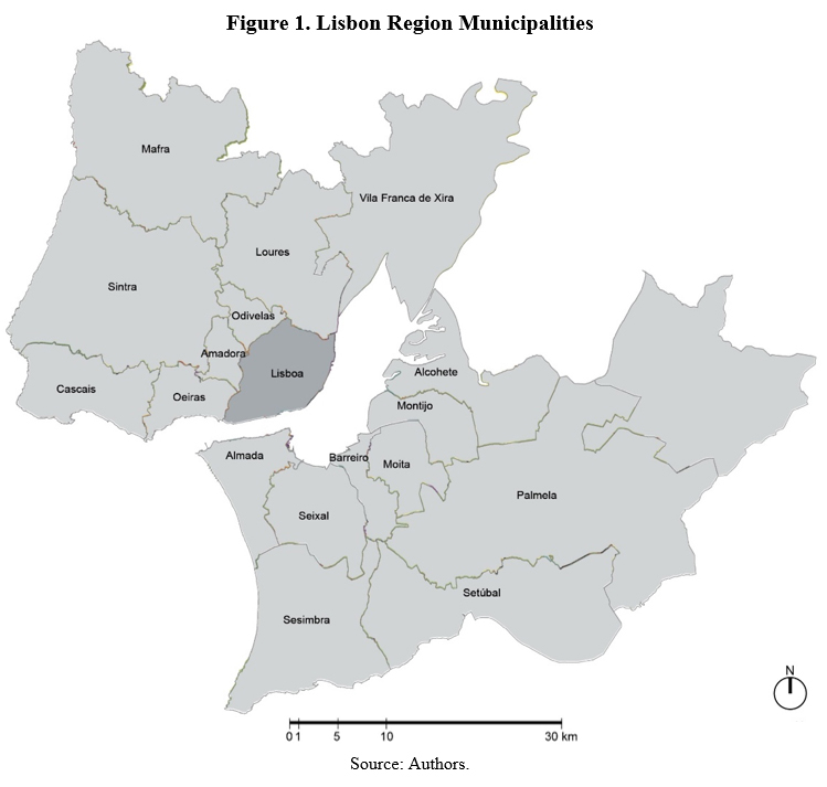
The links between the food system and sustainability are central for project SPLACH – Spatial Planning for Change. This is focused on the Lisbon Region 18 municipalities: Lisbon, Oeiras, Cascais, Amadora, Sintra, Mafra, Odivelas, Loures, Vila Franca de Xira, Almada, Seixal, Barreiro, Moita, Montijo, Alcochete, Palmela, Sesimbra and Setúbal (Figure 1). This configuration was officially established in 1959, aiming at the creation of a spatial regional plan (DL 2099). Currently the most populated Portuguese metropolitan area, it concentrates nearly 2.900.000 people in over 3000 km2 (INE, 2017). The regional food system has been previously researched (Oliveira, 2014; Oliveira et al, 2017), but questions remain regarding the role, past and present, of spatial planning in its formation.
Throughout the 20th century, the Lisbon Region witnessed an unprecedented population and urban growth. This happened in planned and unplanned manners, with input from the public and the private sectors. Modernization and urbanization went hand-in-hand, but the amount of rural land lost to allow these transformations is usually disregarded.
This paper pursues the following questions: what planning strategies have been sought, and how have they applied to rural territories? Has the formal specificity of productive territories been encompassed? Can the food system help critique different planning paradigms, drawing lessons for the future?
After this introduction, section 2 overviews the Lisbon Region and its rural land, and the key instruments of modern Portuguese planning history. Section 3 compares plans at the regional and local scale, exposing two previously unknown urban plans from the 1940s (Palmela and Vila Franca de Xira) and comparing them to currently active spatial planning instruments. We furthermore inspect examples of urban and rural settlements and productive spaces in the selected municipalities, aiming to closely observe their formal specificities. A section for discussion follows, and then a conclusion, highlighting what opportunities can be retrieved for a “metabolic reorganization (…) at various paces and scales” (Ibañez & Katsikis, 2014, 6) of the Lisbon Region and its food system.
1.1. Methodology
Considering the research questions, we start with an historical overview of the Lisbon Region territory, seeking to understand how it was modernized. With regards to its rural dimension, we highlight two current national-scale policies which influence its continuance in the future, the National Spatial Programme (PNPOT), which establishes the goals for national spatial planning, and the National Agricultural Reserve (RAN), which safeguards productive soils in Portugal. We then focus on the specific role of spatial planning in these transformations in municipalities which remain considerably rural, Vila Franca de Xira and Palmela. We compare the first urbanization plan with the currently active PDM and with a morphological analysis of examples of urban and rural settlements and productive spaces.
Our morphological analysis conceptualizes relations between settlements and productive spaces in closer detail. It is informed by M.R.G. Conzen’s (1960) analysis of fringe belts and Whitehand’s (2019, 2020) on green spaces, but extends to the specificities of productive urban green spaces. Moreover, the morphological outline of rural spaces aims to enlighten the agricultural structure of specific forms of production. Such a morphology of rural agriculture shows different spatial arrangements for different crops and productions, from familiar agriculture (smallholdings and horticulture) to industrial (latifundium of monoculture). We also highlighted traditional morphological elements – buildings, plots, blocks, street-systems and urban voids/green spaces.
2. Key themes and literature review
2.1. Rural Lisbon Region
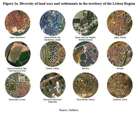
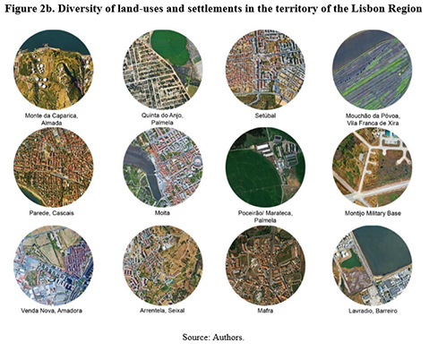
Unevenly distributed throughout the territory, most of the Lisbon Region population lives around the Tagus Estuary. This includes towns, villages, farms, agroforestry, forests and industrial belts. Such diversity (Figures 2a and 2b) has been chiefly regulated at the municipal scale, with national legislation regulating natural areas.
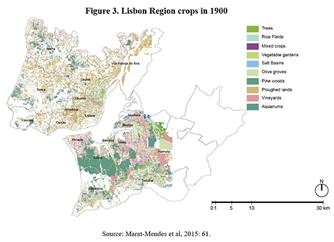
One hardly imagines now how this territory was one hundred years ago. In the transition from the 19th to the 20th century, agriculture was a key activity (Figure 3), with cultivations around all urban settlements (Marat-Mendes et al., 2015). In the European context, the transition from an agrarian to an industrial metabolism was slow. Agriculture occupied the majority of the capital city, but only 4% of its population worked in the primary sector (Niza et al., 2016). The remaining region was also predominantly agrarian, although trainways and industry changed landscapes and the social composition (Lôbo, 1995; Isidoro et al., 2018).
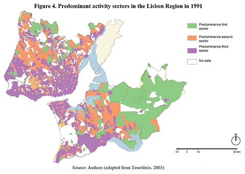
The distribution of economic activities in 1991, (Figure 4) denotes a decrease of rural activities. Many rural villages, still in existence, face population loss, dereliction and abandonment of both settlements and fields (Filipe, 2014; Anastácio, 2008). The segregation of rural space in the Lisbon Region is a recent phenomenon, as in the early 20th century nearly all the regional territory was productive.
During the 1950s and 1960s, the New State (Estado Novo), the conservative dictatorship that ruled Portugal from 1933 to 1974 [5], consolidated the process of modernization. Through regulation of the workforce, concentration of wealth through monopolies and colonial exploitation, the New State achieved an effectively modern capitalism, separating workers from means of production, i.e. turning the peasantry into a proletariat (Varela & Demier, 2015). Throughout this process, a massive movement of people from the countryside to urban cores “meant that there was a good deal of social mobility, employment and consumption at stake, all acting as a kind of social lift” (Varela & Demier, 2015, 428). Cities were hardly prepared: population growth and modernization determined the development of new urban areas, and throughout the 20 th century, such development – and corresponding land-use conversions – did not always comply with planning regulations (Lôbo, 1995; Estêvão, 2015; Mourão & Marat-Mendes, 2016).
The transformation of the regional landscape occurred mostly in the 20 th century and was marked by issues related to private property, while its relationship to planning policies was continuously misinterpreted. During the New State, planning covered only larger settlements, with private development seeking land uncovered by planning (Ferreira, 2015). During the democracy, with PDMs covering the territory integrally, private property often used overrides planning stipulations, although PDMs are binding to the public and private sectors (Mourão & Marat-Mendes, 2016).
Pressures over rural territories still prevail (Abrantes et al., 2016). One key example in the Lisbon Region is its most productive extension, the Great Tagus Wetland and adjacent islets. Over the years, these areas received urbanizations proposals, ultimately rejected. The Great Wetland is run by Companhia das Lezírias, nationalized after 1974, and which has managed production ever since, with profitable results (Talixa, 2005). From an international perspective, since the 1970s, agricultural labour has decreased, almost disappearing (Fischer-Kowalski & Haas, 2014), which in the Lisbon Region is visible in activity sectors (Figure 4).
Currently, the Lisbon Region is understood mostly from the perspective of its cities, notably the Portuguese capital. However, it includes extensive rural land, acknowledged in several spatial policies – from the PDMs to extra-municipal documents.
2.1.1. The RAN
Agrarian land has important environmental impacts, and emerging forms of agriculture – such as organic agriculture or farming, and permaculture – have been acknowledged for their environmental advantages. This was a key goal of the national instrument to preserve the soil resource and its allocation to agriculture (MADRP, 2009), the RAN. Its creation in 1982 defined productive areas needing legal protection, managed by representative regional agencies (DL 196/1989).
In its 2009 version, RAN management is mainly ensured by the General Commission for Agriculture and Rural Development (DGADR). However, the Regional Coordination Commissions (CCDR) also share responsibilities regarding organization and territorial planning.
Currently, only land units with a high/moderate aptitude for agricultural activities integrate the RAN (MADRP, 2009). However, a particular area can be included (or excluded) if it receives a major investment to increase productive capacity, if its use is critical for the economic viability of agricultural holdings or if it holds strategic interest (MADRP, 2009). Conversely, land from urban perimeters classified in the PDM as urbanized soil, for urbanization or ecologically relevant soil, cannot integrate the RAN (MADRP, 2009) and urban soils in inter-municipal plans are also excluded (DL 199/2015).
All actions that weaken or destroy agricultural potential, including urbanization or expansion works are forbidden, but may materialize if there is no viable alternative outside RAN land. Exceptions include rural tourism and adequate leisure activities (MADRP, 2009). In principle, the RAN locates highly productive land and promotes good practices.
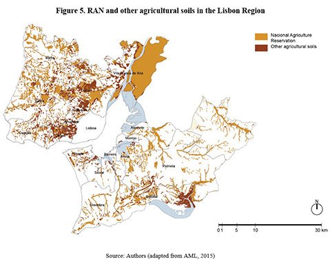
In the Lisbon Region, RAN soils exist in all municipalities except Lisbon, while other agricultural soils cluster around RAN in a similar pattern (Figure 5). Most of the RAN is on the Northern Bank, with the Great Wetland and three islets as the most consistently productive areas, followed by the Loures Floodplain and furthermore in Sintra and Mafra. On the Southern Bank, the RAN is diffuse, with significative chords in the Montijo exclave, Palmela, Alcochete and Setúbal. In Setúbal, Almada, Loures and Oeiras, considerable extensions of agricultural soils are excluded from the RAN.
2.1.2. The PNPOT
The PNPOT was created by the 1998 Planning Act (DL 48/98) as the highest territorial management instrument for the national territory. The first PNPOT ran from 2007 to 2013 (DGT, 2019) and was replaced in 2019. It acknowledges relevant emerging trends in four domains: environmental and climate; sociodemographic; technological and economic, and social (DGT, 2019).
In the areas of “Climatic and Environmental Change” and “Economic and Social Change”, the PNPOT acknowledges the food system as a concern for spatial planning under a sustainability perspective (DGT, 2019). It highlights the impact of environmental degradation in food and water management, the need to ensure proper food supply and to increase the resilience of natural, agricultural, forestry and community systems, considering that the country may face risks of deprivation in the future, under climate changes (DGT, 2019). The socio-ecological challenges in citizens’ lifestyles, including more sustainable habits are mentioned, as is the rise of circular economy including rural-urban or relationships dynamized by short-supply and consumption chains, shared logistics, deposits of materials and ecocentres (DGT, 2019). This direct acknowledgement on the role of planning in making the food system more resilient and sustainable is a milestone for spatial planning and the territory itself, if successfully incorporated into planning instruments.
2.2. Historical change in planning strategies
The need to plan the Lisbon Region as such was first acknowledged by Étienne de Gröer, a Russian architect invited in 1936 by Minister of Public Works (1932-1936 and 1938-1943) and Mayor of Lisbon (1938-1943) Duarte Pacheco to coordinate planning in some Portuguese cities. Pacheco played a pivotal role in establishing spatial planning and hiring professionals for such work, although resulting plans were often undercut by the State who rejected them or approved them as Foreplans, thus depriving them of binding value (Lôbo, 1995).
In the 1950s, it was acknowledged that private developers were disorderly transforming the regional territory (Ferreira & Lucas, 2002; Solans, 2002). In 1960, a regional plan was started but ultimately rejected. However, until the publication of the PROT-AML (2002), that was the only instrument conceiving the regional territory integrally.
2.2.1. The regional scale
The first wave of modern Portuguese planning instruments was defined in the 1930s. The roles of Duarte Pacheco and of Lisbon chief-planner Étienne de Gröer have been widely acknowledged (Silva, 1994; Lôbo, 1995; Pereira, 2009; Marat-Mendes & Oliveira, 2013; d’Almeida, 2015; Marat-Mendes & Sampayo, 2015). What has been less noticed is that the sub-regional scale greatly shaped design and planning practices in this era.
Gröer conceptualized a plan for the Lisbon Region and its extensions (Figure 6), predicting the main suburban axis, incorporating his first Portuguese plan, the sub-regional ‘Plano de Urbanização da Costa do Sol’, started by Donat-Alfed Agache in 1936 but concluded in 1948 under Gröer’s guidance (Pereira, 2009).
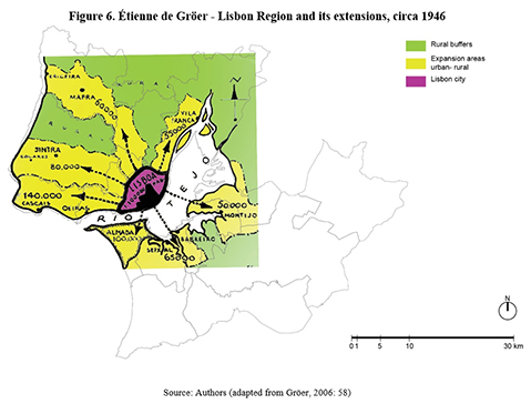
Gröer’s planning ideas followed the Garden City model by Ebenezer Howard (Lôbo, 1995; Marat-Mendes & Oliveira, 2013). In the suburban extensions, urban cores were separated by rural buffers to prevent the merger of different settlements. The plan covered only main urban settlements (Lôbo, 1995).
There were other sub-regional plans in the 1940s and 1950s, namely from Loures to Vila Franca de Xira by Gröer and for the Southern Bank of Tagus by Paulo Carvalho e Cunha, while many local plans were designed outside these axes (Lôbo, 1995).
In 1964, a Lisbon Regional Plan was concluded, but remained unapproved. It classified regional soils integrally, identifying the main suburbs outside the Lisbon city borderline. Although conceived under the dictatorship, until 2002, this was the only instrument classifying the territory in a regional perspective. Interestingly, regional planning changed less with democracy than local-scale planning.
In 2002, the first democratic Lisbon Regional Spatial Plan (PROT-AML) was published and approved (CCDRLVT, 2002). It provided a systematic view of the region, with land-uses defined as ‘actions’, i.e. interventions for each area. However, its territorial model (Figure 7) applied actions only to urbanized land, keeping rural areas for agriculture, agroforestry, forestry and natural spaces.
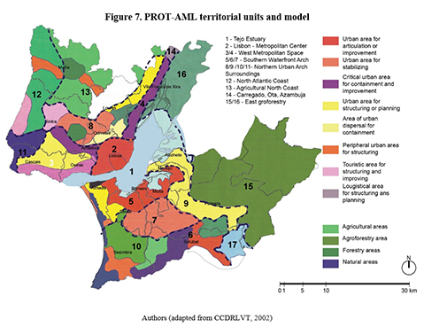
It is so, because this planning instrument only aims to determine what infrastructures and equipment are necessary in the region and where to place it. The management of rural zones is ensured by private owners and thus is left unplanned. The region is further divided into several Territorial Units (UT), to be planned integrally with specific combinations of different actions and land-uses (CCDRLVT, 2002, 42).
The PROT-AML synthesizes a peripheral ‘rural crown’ (Figure 8) in the North, NE and SE ends, engulfing the Tagus estuary urban cores. From 16 UTs, this rural crown comprises four of them, although these amount to a very considerable extension of the Lisbon Region.
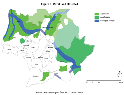
These UTs are generally larger but relatively more uniform than urban cores, usually smaller and fragmented. UT12 includes two urban areas for stabilizing (Colares – Magoito and Mafra – Ericeira), while the rural component is uniformly agricultural. UT13 includes mostly agricultural land, except for the Tapada de Mafra (forestry) and the Malveira – Lousa axis (peripheral urban area for structuring). Separated from UT13 by an urban chord, UT16 is exclusively agricultural, extending in and around the area known as Sea of Straw (Mar da Palha): it includes the Great Wetland plus three islets, all alluvium formations with high agricultural potential. Finally, UT15 is the largest UT of the PROT-AML, and it is almost exclusively occupied with agroforestry, except for two peripheral areas for structuring, the towns of Benavente and Samora Correia, both outside the Lisbon Region. Most of its territory includes rural land of Palmela, Alcochete and all the Montijo exclave.
The distribution of activity sectors in the Lisbon Region (Figure 4) has a correlation with the rural crown [6]: although in the UT16 there is a predominance of first sector activities, in UT12 and UT13, mostly agricultural, there is a mix of first and second sectors, suggesting that agricultural labour was disappearing (Filipe, 2014).
2.2.2. The municipal scale
During the New State, planning was mandatory for settlements with 2,500 or more inhabitants (Lôbo, 1995). Pacheco was aided by Agache and Gröer in conceiving planning guidelines, and his 1934 legislation aimed towards the configuration of urban settlements, location of equipment, sanitary improvement and inception of mobility infrastructures (Silva, 1994; Lôbo, 1995).
Urbanization plans were charged to municipalities, but their lack of preparation empowered the central State to dynamize it (Lôbo, 1995). This ended poorly: in 1946, the State created a new instrument, the urbanization foreplan, a simplified project lacking binding power (Lôbo, 1995), which made planning ineffective and by the 1960s, simply chaotic (Silva, 1994).
In 1974, the country underwent a political Revolution. A military coup overthrew the dictatorship and started a democracy. The aftermath of the April 25th Revolution, a 2-year period of Ongoing Revolutionary Process (Processo Revolucionário em Curso), approached several urban problems, with housing occupation in Lisbon and Porto, but also the Agrarian Reform, which sought to restructure Portuguese rural space, questioning land-ownership and demanding it would be given to workers (Varela, 2019).
Yet this was not reflected in planning policies. In 1982, the State handed to municipalities responsibility over territorial planning (DL 208/82) by establishing the PDM, directed at socio-economic development, not design (Lopes, 1991). In 1998, this was replaced by a new Spatial Planning Act (updated in 2014), predicting a larger scheme, ranging from the PNPOT to the regional and municipal scales, and smaller-scale Urbanization Plans and Detailed Plans (DL 48/98). However, the PDM remained the only mandatory instrument.
3. Case studies
Here we analyze two examples of municipal plans, from Lisbon Region municipalities which maintain today a considerable rural area, Vila Franca de Xira and Palmela, as well as examples of urban and rural settlements and productive spaces in both municipalities.
3.1. Vila Franca de Xira
3.1.1. The 1946 Urbanization Plan
Vila Franca de Xira was the end pole of the northern Lisbon extension (Figure 6). Its Urbanization Plan (Plano de Urbanização de Vila Franca de Xira) of 1946 (Figure 9) was designed by architects Miguel Jacobetty Rosa and João Guilherme Faria da Costa, who had collaborated before, in the Alvalade neighbourhood, planned by the latter and which included several buildings designed by the former. Both were also involved in planning Lisbon suburbs, as with Mafra’s 1947 plan by Jacobetty (1947) and Amadora’s or Almada’s by Faria da Costa (1946 and 1949 respectively).
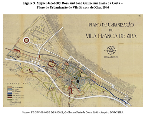
Vila Franca de Xira was strongly rural but industrialized. Its projected growth was physically blocked by the riverside road, the forthcoming bridge over the Tagus and the Alviela and Tagus water-channels (Jacobetty & Costa, 1946a).
The plan sought to control population growth and ensure sanitary conditions and mobility. A land-use system is designed, with six categories: first a preexisting area of collective housing and commerce; a second with a proposed urban extension with housing and equipment; a third with poor detached houses; a fourth with a planned residential area; a fifth for industry and a sixth with the planned market and sports area (Jacobetty & Costa, 1946a).
Physically, this plan maintains the organic original settlement, introducing two new orthogonal avenues with symbolic buildings and a square, larger than preexisting plazas. The planned extension sprawls northwards with three main zones: one with detached houses, another with collective residential buildings and the third with sports facilities, including a new bull-race arena. This is located on a floodplain with great productive potential. Although the preferred housing type is the single-family home, the plan includes collective housing limited to four residential floors (Jacobetty & Costa, 1946b). A rural zone is defined, but not regulated, on the periphery.
This plan was approved as a foreplan, but not implemented. The old settlement changed, but differently from this plan. The main extension was not built, and a new residential core sprouted on the east, not the north of the original core. The predicted demolitions did not happen, and the new sports area remained rural until very recently, when an upcoming urbanization was approved.
3.1.2. The 2009 PDM
Written under the 1998 Spatial Planning Act, the current Vila Franca de Xira PDM has a very detailed land-use system (Figure 10).
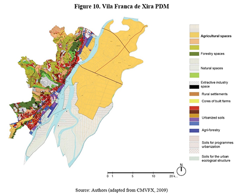
It presents very specific dispositions for both the rural and the urban soils, often leaving unclear whether the municipality would prefer to preserve and refurbish its past structures or the implementation of new ones. This potentially makes activities and constructions more flexible.
Agricultural space comprises three subcategories: Type 1 – soils with greater agricultural potential, included in RAN and other entities (CMVFX, 2009, Art.14); Type 2 – the remaining soils from RAN (CMVFX, 2009, Art.17); and Additional Agricultural Spaces, not included in RAN but still productive (CMVFX, 2009, Art.20).
Notably, the most productive soils are not regulated by the PDM, but rather by RAN (CMVFX, 2009, Sec.II, Sub-sec. I and II). The PDM does regulate directly the subcategory of Additional Agricultural Spaces, preferentially maintained for agriculture, although some forms of housing, agroindustry, tourism, leisure or equipment are not precluded (CMVFX, 2009, Art.21).
In the subcategory Additional Agricultural Space, allowed uses include agroindustry, transformation and selling of the produce of agriculture, livestock or forestry (CMVFX, 2009, Art.21-2-a). The corresponding construction regime is small-scale and low-density.
3.1.3. Morphological analysis
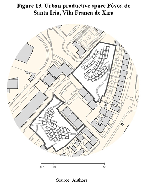
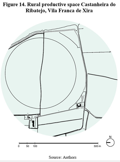
For the urban settlement we observed the main town of the municipality (Figure 11) and for a rural settlement, the village of Cachoeiras (Figure 12). For the urban productive space, we have analyzed the allotment gardens of Póvoa de Santa Iria (Figure 13), the largest municipal urban agriculture initiative in Vila Franca de Xira; while for the rural productive space, we selected an area in Castanheira do Ribatejo (Figure 14), near the northern municipal borderline.
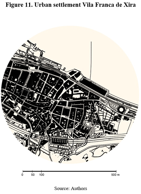
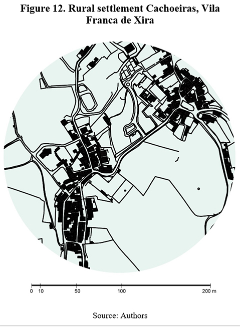
In Vila Franca de Xira (Figure 11) the old core has tightly knitted blocks adapted to the landscape with circulation on the remaining space. In modern extensions, space is defined by building series, public space and motorways, while on the outskirts, secondary roads are still visible, with disperse buildings. Modern construction was inbuilt into the original urban structure.
In the village of Cachoeiras (Figure 12) there are two linked cores, with disperse housing all around, engulfed by agricultural spaces.
The urban productive space is a municipal allotment garden system in Póvoa de Santa Iria (Figure 13), which occupies all available space around a block limited by high-rise housing on the southeast and by equipment on the northwest. Agricultural plots are adapted to the territory. Here, the municipal allotments were incepted into a preexisting garden and are meant to remain.
With agricultural patches, there is a great diversity in Vila Franca de Xira. One example is the large exploration field, marked by immense plots of monoculture, whose shapes are strongly defined by machinery. Such is the case in Castanheira do Ribatejo (Figure 14). This type of exploration can be found in Vila Franca de Xira in the Great Wetland and in the mainland territory. In Castanheira irrigation ditches optimize the proximity to Tagus water as a resource.
3.2. Palmela
3.2.1. The 1948 Urbanization Plan
Like Vila Franca de Xira, Palmela was a small-scale town which was becoming insufficient for its population growth (Aguiar, 1948). The architect selected for designing the Urbanization Plan (Plano de Urbanização da Vila de Palmela – afterwards Anteplano) was João António Aguiar, whose polemical plan for Setúbal (1944), south of Palmela, proposed large new avenues through massive demolitions on the old settlement (Lobo, 1995). Aguiar’s work for Palmela was designed as a plan but was approved, after revision, only as a foreplan in 1948 (Figure 15).
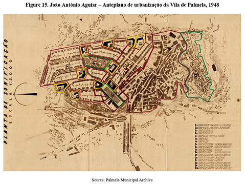
The street-system of the old core is generally maintained while widening some streets to accommodate traffic. The extension area is planned to the north, with four types of zones: housing; commerce, services and housing; green areas; and reserved plots. The new housing neighbourhoods have detached and semi-detached housing, with respectively one and two floors. In other zones, commerce and public services are programmed for the ground-floors, occasionally allowing a height of three floors (Aguiar, 1948).
Furthermore, a 600 metres rural reservation is stipulated around the town for agriculture and supporting facilities, as well as detached houses. A slaughterhouse is recommended for the outside of the Foreplan area, midway to the Quinta do Anjo settlement (Aguiar, 1948).
Like most plans of that time, the Palmela Foreplan is limited to the main urban settlement and its projected extension, excluding the remainder of the strongly rural territory. But the Foreplan does acknowledge the local rural economy, presenting a survey on ‘Commerce and industry’ (Figure 16), the majority of which are food-related: winehouses, taverns, grocery shops, bakeries, butchers, dairies, olive oil mills and restaurants. A map specifically for winehouses is also included. While no special attention is paid to this kind of commerce in the urbanization plans themselves, such surveys testify to the pivotal importance of food-related activities in Palmela.
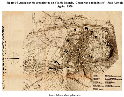
In 1954, Aguiar presented a ‘Remodeling’ [7] of the Foreplan, mentioning the existence in the old settlement of grocery shops, taverns and workshops in acceptable conditions and of winehouses, warehouses, stables, haystacks and garages in poor conditions. Unsanitary commercial facilities are surveyed, listing mills, warehouses, barns, winehouses, stables, forgers, coopers, bakeries, taverns and shoe shops (Aguiar, 1954).
The remodeling has more detailed zoning, while height limits for buildings with commercial ground-floor rise to three and even four floors. The slaughterhouse is moved to the northwestern limit of the town, and an industrial zone (inexistent in 1948) is placed on the southeastern limit for stables, barns and mills eliminated from the old core. Furthermore, the ‘Protection rural zone’ is extended to 1 km, and beyond agriculture and rural buildings, public buildings and some industries are now allowed in it (Aguiar, 1954).
In 1955 Aguiar’s remodeled Foreplan was approved but it cannot be considered implemented. Most streets in the old core retained their original dimensions and were not intervened. Some of the new blocks were urbanized more or less as planned, with only slight changes in the street-system layout. Four-floor height in the areas immediately close to the old core are in line with the stipulations of the remodeling, but on northwards, five- and even six-floor tower-blocks replaced low-rise housing stipulated by Aguiar.
The rural protection buffer can be confirmed in the immediate surroundings of the town, where indeed only a few buildings were constructed alongside agricultural fields. However, this buffer does not extend for a 1 km offset around the town edge and in some points, low-density suburbs have developed, including Volta da Pedra, Aires, Baixa de Palmela, Pegarias, Carvalhos and S. Braz.
3.2.2. The 1997 PDM
The current PDM has an integral land-use system. It is one of the Lisbon Region PDMs following the 1982 PDM Act. It conceives a land-use system (Figure 17), as well as special regimes, including natural parks, protection areas, natural reservations and areas for intervention. This is important considering most of the municipal territory is rural, with only some properly urban areas, all located westwards.
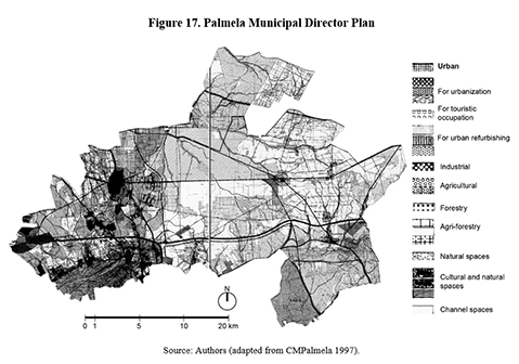
The land-use of agricultural soils is divided into two categories: the first includes spaces with potential for agriculture included in RAN (CMPalmela, 1997, Art.16-1); while the second includes spaces with potential for agriculture included in REN [8] (CMPalmela, 1997, Art.17-1). Agri-forestry spaces are divided into categories: the first includes soils with high agricultural diversity in small properties, considerable level of infrastructure and high dispersion and density of constructions (CMPalmela, 1997, Art.19-1); while the second includes soils used for agriculture or forestry and where there are currently no conditions for urban uses (CMPalmela, 1997, Art.20-1).
In both categories of agricultural space, allowed uses are those that do not destruct the soils’ potential (CMPalmela, 1997, Art.16-2 and Art.17-2). Construction is limited to supporting structures and housing for farmers (CMPalmela, 1997, Art.16-3-a and b; Art.17-3-a and b). Given the number of special regimes in the municipality’s territory, the PDM mostly ensures the unity and cohesion of territorial development.
3.2.3. Morphological analysis
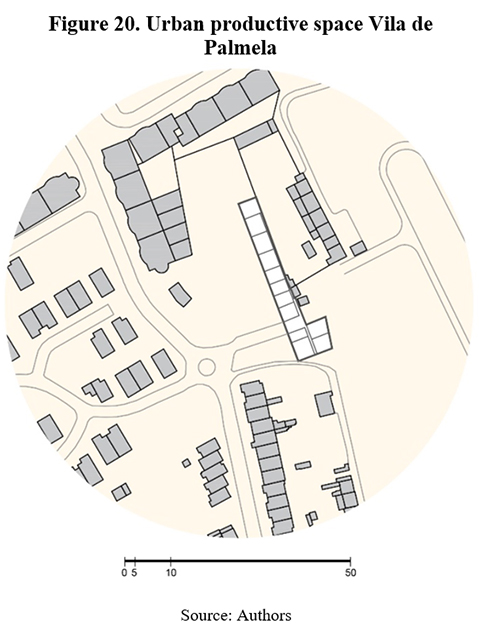
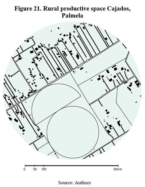
For the urban settlement we observed the main town of the municipality (Figure 18) and for a rural settlement, the village of Águas de Moura (Figure 19). For the urban productive space, we have analyzed the allotment gardens in the main town itself (Figure 20); and for rural productive space, an area in Cajados (Figure 21).
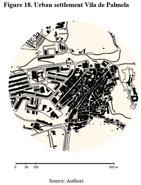
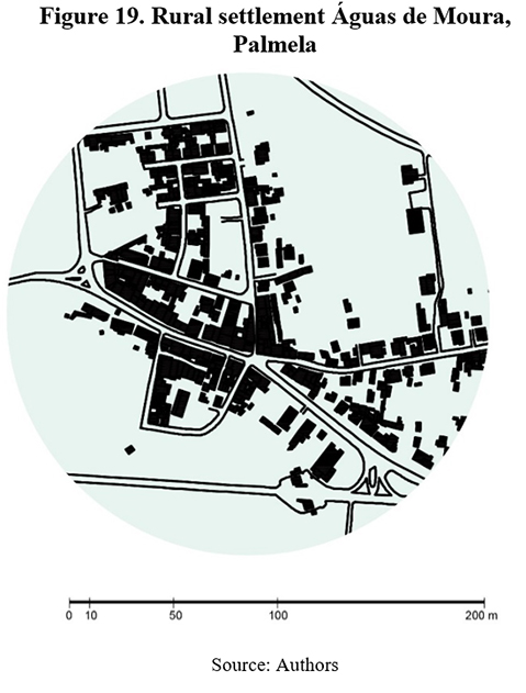
In Pamela town (Figure 18) the old core is similar to Vila Franca de Xira, with small blocks and winding streets on the remaining space, and with modern extensions through linear streets and blocks with planned public spaces. In the village of Águas de Moura (Figure 19), there is a concentration around the major motorway with disperse housing in ribbons around, surrounded by vacant spaces and forestry areas.
In Palmela (Figure 20) we analyzed a municipal allotment garden, occupying a portion of available space south of the settlement, placed in land for future urbanization. Since Palmela is predominantly rural and has few examples of high-density or high-rise living, residents have more agricultural space available nearby.
In this municipality there are also great latifundia, but in Cajados (Figure 21) the large surfaces coexist with a different patch, formed by smaller agricultural plots. These tend to be narrow and elongated, either defined by different crops or to the extension of the plot occupied by detached houses.
4. Turning no name places into sustainable spaces: towards a transition of unsustainable food systems
The New State privileged design-based planning, although only in already existing settlements, leaving the remainder of the territory unplanned, particularly in its rural areas. This created areas empty of purpose, or ‘no name areas’. This originated unregulated urbanizations and a chaotic wave of land-use conversions totally guided by private actors (Ferreira, 2015; Mourão & Marat-Mendes, 2016). In a sense, the democratic PDM acknowledges this problem by encompassing all the territory. Although each municipality is responsible for its PDM, the sum of all would amount to the overall national land. Sub-regional and even regional plans were developed during the dictatorship for the Lisbon Region, but were undercut, a frailty which remained in the democratic period. Consequently, there were less changes in planning at the regional scale. While Gröer’s scheme of ‘Lisbon Region and its extension’ was clearly akin to his local-scale plans, with planned urban areas and the delineation of rural buffers, the 1964 regional plan had an integral land-use scheme, which the 2002 PROT-AML would follow.
The centrality of land-use for planning strategies in Portugal is associated with the country’s reliance on the Roman Law, based on abstract general rules (Oliveira, 2006). Yet, there is also a shift in the historical role of land-use. It starts in 1960s at the regional scale, but then becomes the key strategy of the local scale, previously focused on design. This seemed like a natural outcome of the democratic process, since design was not conditioned by the State’s preference for any given urban form.
However, a less optimistic perspective is possible. First, across different planning paradigms, rural spaces have consistently been excluded from design. Secondly, while the current integral scheme of land-uses includes rural territories, corresponding regulations, as seen in the case studies, protect dominant activities without including them in a wider spatial or socio-economic strategy. This role is usually reserved for urban territories. In many instances, agricultural land is not managed by the PDM but by the RAN. Thus, the de facto management of this land is handled by national and regional entities.
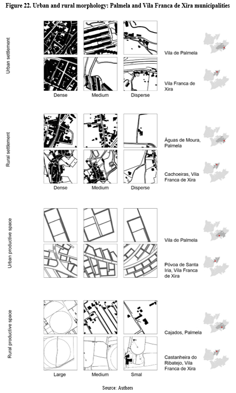
A closer inspection of the territory demonstrates that ‘urban’ and ‘rural’ are indeed highly abstract notions that do not accurately represent the existing diversity of residential and productive activities and land-uses (Figure 22). Although this is intuitively acknowledged with regards urban land, it may not be so in rural ones, where diversity is great, but usually unacknowledged.
Indeed, the inherent logic of current Portuguese planning confirms the dependence of planning on a chain of production and consumption as spatially separated activities (Weaver, 1984). This is the pinnacle of a process of separation of the people from the land which was key to modernizing the Portuguese territory, but also to advance capitalist economy (Varela & Demier, 2015). So, it is unsurprising that contemporary Portuguese cities are uncritically considered as places of consumption. Considering the tremendous loss of rural space in the Lisbon Region, instruments like the RAN have great importance on safeguarding whatever productive soils are still left. However, the RAN’s emphasis on preservation cannot remain unchallenged. While there is an unsurmountable need to prevent rural soils from opportunistic conversion into housing or touristic developments, these soils cannot be excluded from territorial transformation and should integrate a sustainable evolutionary process of metabolic change.
In face of institutional and popular demands for transformations of the food system, acknowledged internationally by institutions such as FAO (2019) and nationally by the PNPOT (2019), productive soils must receive planning from the public sector. There are many positions on the role the private sector may assume, but it cannot continue to command the food system single-handedly. Reconsidering this problem leads us to think of industrial logistics, but also of planning and land property.
During the New State, Portugal witnessed the creation of Agricultural Colonies, State-planned villages whose residents received a house with an agricultural plot, an experience whose ‘agrarian ultraconservative’ overtones (Rosas, 1996) remain uncomfortable. However, the rising discussion about eco-neighborhoods (Barton, 1998) and ecological communes (Kanter, 1972; Cattaneo, 2015; Bartlett, 2017) provides opportunities for reconsidering such a planning and design operation under new perspectives. Spatial patterns of dispersed concentrations have often been hailed for giving shape to mixed-uses and energy-constraint (Barton, 1998), with proximity metabolisms based on local agriculture, which decreased consistently in Portugal.
5. Conclusion: Reshuffling planning schemes?
Whether or not through the creation of new, more sustainable settlements would aid a transition to the current metropolitan food system, the inclusion of rural territories in spatial planning is critical to achieve a circular metabolism and local food-supply chains. Thus, the urban-rural schism must be overturned. The very transversal nature of the food system helps us rethink the territory as a whole, emphasizing the interdependence of its phases and integrating them in shorter and more resilient interlinked units. Design, more than land-use, is critical for creating the necessary spatial arrangements. But for this, planning needs more than reform: it needs to be reconceptualized at its roots.
Urban design physically organizes possible forms for human occupation (Ibañez & Katsikis, 2014), but planning seldom assumes this role now. In Portugal, it mostly translates market interests. From the brief historical overview of the Lisbon Region, we see that society, culture and landscape have changed tremendously in a short time-period. Planning structures, even ineffectively, changed too.
Different planning paradigms, over a century apart, share a belief that only urban spaces need or can be planned. Only the planning strategy changed: design in the earliest plans, land-use now. Also, in terms of content, the preference for a specific image of the city is clear in the New State plans, which prioritize centralized equipment and low-rise low-density development – as if to stifle eventual growth of rural towns. But for rural territories, strategies did not change and preferences were seldom expressed. Assumed as ‘natural’ buffers to avoid conurbation, whether directly (during the dictatorship) or indirectly (now), the rural surroundings of the Lisbon Region have always remained secondary.
As Weaver (1984) indicted, planning became an extension of capitalist ideology, but as Moorcroft (1972) noticed, change requires planned design, not just assignment of functions. Important steps were taken in the main Portuguese cities (Lisbon and Porto) to move beyond the basis on land-use, but this again focused on regulating urban areas. These PDMs, whose zoning is based on urban fabric typologies (Oliveira, 2006), demonstrate how reductive land-use can be as a planning strategy. But our morphological analysis sample shows how generic categories of rural land-uses are also reductive, telling us nothing agricultural patches, explorations or relation to settlements. In other words, such land-uses merely delineate where agricultural businesses are adequate. While the RAN goes a step further, promoting good practices, it provides plenty of exceptions for economic activities.
This bias also permeates regional planning, where a land-use basis seems more reasonable, but where, again, the opposition between urban and rural excludes the latter from significative strategies. A sustainable transition of the territory demands consideration from a metabolic perspective, to which land-use is helpful. But even in this case, a more sustainable region cannot be achieved by planning urban areas alone – rural land plays a key part in this process, as the food system illustrates.
In our morphological survey of productive spaces, differences are obvious in physical properties, design demands and relations with built masses – thus, these spaces can be the object of a design-based planning. However, such option is conceptually blocked by legislative frameworks and paradigmatic values associated with planning and the public sector itself.
Although it can be reasonably concluded that the design-based planning of the New State left little margin for change and showed a clear preference for specific urban forms, design remains today a fundamental tool for specifying how a social and environmental strategy is marked on the territory.
Morphological knowledge on settlements and productive spaces can sustain planning and design strategies. The design of the urban allotment gardens in Póvoa de Santa Iria stands out, for its minute attention to the availability of land among high-rise buildings and its strategy of separate but connected clusters of urban agriculture, bringing diversity and balance to a territory marked by massive constructions. The food system can have great planning advantages, providing a concrete social basis to counter the environmental one, allowing a direct relationship between productive activities and the inhabitants of a settlement.
The Lisbon Region has proven to be adaptive, but it must continue to change. So, the question about planning is if it should remain attached to its current paradigm, and risk becoming obsolete, as happened in the first half of the century; or follow head-on the radical challenges, already on move to contribute for a transformation of its territory as urged by the sustainability paradigm.
Acknowledgements
The authors thank the ‘Arquivo Histórico de Vila Franca de Xira’, particularly its chief-archivist José Rocha, and the ‘Arquivo Histórico de Palmela’, particularly its chief-archivist Ângela Camolas e Sousa, for kindly helping us accessing the historical urban plans. Further thanks to the Forte de Sacavém Archive (Direção-Geral do Património Cultural), particularly Dr. Cátia Taveira Martins, for assisting with the written documents of the 1946 Vila Franca de Xira Plan.
The authors are also grateful for the valuable comments of the two reviewers who contributed to improve the original manuscript into its present form.
This work was financed by grant POCI-01-0145-FEDER-016431, by the European Structural and Investment Funds (ESIF) through the Operational Thematic Program for Competitiveness and Internationalization (COMPETE 2020) in its European Regional Development Fund and by National Funds through the Foundation for Science and Technology Portugal (FCT).
References
Abrantes, P., I. Fontes, E. Gomes, J. Rocha (2016) “Compliance of land cover changes with municipal land use planning: Evidence from the Lisbon metropolitan region (1990–2007)”, Land Use Policy 51: 120-134.
Aguiar, J.A. (1948) Anteplano geral de urbanização de Palmela. Arquivo Municipal de Palmela (typescript). [ Links ]
Aguiar, J.A. (1954) Anteplano geral de urbanização de Palmela – remodelação. Arquivo Municipal de Palmela (typescript).
Anastácio, M. (2008) Território e Identidade: aspectos morfológicos da construção do território e a identidade cultural saloia no Concelho de Cascais. Unpublished Master Thesis in Architecture. Lisboa: ISCTE. [ Links ]
Bartlett, J. (2017) Radicals, London: Windmill. [ Links ]
Barton, H. (1998) “Eco-neighbourhoods: A review of projects”, Local Environment, 3:2, 159-177.
Brinkley, C. (2013) “Avenues into food planning: a review of scholarly food system research”, International Planning Studies, 18:2, 243-266.
Comissão Coordenadora do Desenvolvimento Regional de Lisboa e Vale do Tejo (2002) Plano Regional de Ordenamento do Território – AML. Lisbon: AML.
Câmara Municipal de Vila Franca de Xira (2009) Plano Director Municipal de Vila Franca de Xira. Aviso n.20905/2009. Diário da República, 2.ª série N.224 18 Novembro. [ Links ]
Câmara Municipal de Palmela (1997) Plano Director Municipal de Palmela. Resolução do Conselho de Ministros n.115/97. Diário da República I Série – B. N.156 9 Setembro.
Cattaneo, C. (2015) “Eco-communities”, in G. D’Alisa, F. Demaria, G. Kallis (Eds.), Degrowth. London: Routledge, 165-168.
Cohen, N., Ilieva, R. (2015) “Transitioning the food system: A strategic practice management approach for cities”, Environmental Innovation and Societal Transitions. DOI: https://doi.org/10.1016/j.eist.2015.01.003 .
Conzen, M.R.G. (1960) Alnwick, Northumberland. London: Institute of British Geographers. [ Links ]
Decreto-Lei 2099 de 14 de Agosto, Promulga as bases do plano director do desenvolvimento urbanístico da região de Lisboa. Diário do Governo, nº 186/1959, Série I. Presidência da República. [ Links ]
Decreto-Lei 196/1989 de 14 de Junho, Regime jurídico da RAN. Diário da República n.º 134/1989, Série I. Ministério da Agricultura, Pescas e Alimentação [ Links ]
Decreto-Lei 48/98 de 11 de Agosto, Lei de bases da política de ordenamento do território e do urbanismo. Diário da República n.º 222/1999, Série I-A. Ministério do Equipamento, do Planeamento e da Administração do Território. [ Links ]
Decreto-Lei 199/2015 de 16 de Setembro. Regime jurídico da RAN. Diário da República n.º 181/2015, Série I de 2015-09-16. Ministério da Agricultura e do Mar. [ Links ]
Direção-Geral do Território. (2019). Programa Nacional da Política de Ordenamento do Território - Primeira Revisão baseada na lei no 99/2019. [ Links ]
D’Alisa, G., F. Demaria, G. Kallis (2015) Degrowth: a vocabulary for a new era, London: Routledge.
d’Almeida, P.B. (2015) Bairro(s) do Restelo, Lisbon: Caleidoscópio.
Estêvão, A.L.G.B. (2015) A incerteza no processo urbano. Unpublished PhD thesis, Universitat de Barcelona. [ Links ]
Ferreira, B.M. (2015) (In)formar a cidade contemporânea. Unpublished MSc thesis, ISCTE-IUL. [ Links ]
Ferreira, A. F., Lucas, A. (2002) “Área Metropolitana de Lisboa – dar vida aos subúrbios”, Sociedade e Território 33: 36- 45.
Filipe, M. (2014) Aldeias Abandonadas na Área Metropolitana de Lisboa, Lisboa: Novas Edições Académicas. [ Links ]
Firth, R. (2012) “Transgressing urban utopanism: Autonomy and active desire”, Geografiska Annaler Series B, 94(2): 89-106.
Fischer-Kowalski, M., Haas, W. (2014) “Exploring the transformation of human labour in relation to socio-ecological transitions”, in M. Beblavý, I. Maselli, M. Veselková (eds) The future of labour in Europe, vol.1. Brussels: CEPS.
Fischer-Kowalski, M., Weisz, H. (2016) “The Archipelago of Social Ecology and the Island ofthe Vienna School” in H. Haberl, M. Fischer-Kowalski, F. Krausmann, V. Winiwarter (eds.) Social Ecology, Switzerland: Springer, 3-28.
Groer, E. de (2006). “Plano de Urbanização do Concelho de Almada”. Anais de Almada, 7-8: 151-236.
Gu, K., Li, Y., Zheng, X. (2019) “A typological approach to planning”, Journal of Urbanism, 12(4): 373-392.
Hass, T., Westlund, H. (eds.) (2018) In the Post-Urban World, London: Routledge. [ Links ]
Ibañez, D., Katsikis, N. (eds.) (2014) “Grounding metabolism”, New Geographies, 6.
INE (Instituto Nacional de Estatística) (2017) Área Metropolitana de Lisboa em números/ in figures 2015. Lisbon: Instituto Nacional de Estatística. [ Links ]
Isidoro, I., Marat-Mendes, T., Tângari, V. (2018) “The Portuguese railway in time and space”, Planning Perspectives, 33:3, 363-384.
Jacobetty, M., Costa, J.G.F. (1946a) Anteplano de Urbanização de Vila Franca de Xira - relatório. Arquivo do Forte de Sacavém – GFC 12-38-162.
Jacobetty, M., Costa, J.G.F. (1946b) Anteplano de Urbanização de Vila Franca de Xira - regulamento. Arquivo do Forte de Sacavém – GFC 12-38-162.
Kanter, R.M. (1972) Commitment and Community: Communes and Utopias in Sociological Perspective , Harvard University Press. [ Links ]
Kropf, K. (1996) “An alternative approach to zoning in France”, European Planning Studies, 4(6): 717-737.
Lôbo, M.S. (1995) Planos de Urbanização: A época de Duarte Pacheco, Porto: FAUP. [ Links ]
Lopes, R.G. (1991) Planeamento municipal e intervenção autárquica no desenvolvimento local , Lisbon: Escher. [ Links ]
Ministério da Agricultura, do Desenvolvimento Rural e das Pescas (2009) Decreto-Lei 73/2009. [ Links ]
Marat-Mendes, T., Oliveira, V. (2013) “Urban planners in Portugal in the middle of the twentieth century: Étienne de Groër and Antão Almeida Garrett”, Planning Perspectives, 28(1): 91-111.
Marat-Mendes, T., Mourão, J., Bento d’Almeida, P., Niza, S. (2015), Water and Agriculture Atlas: Lisbon Region in 1900-1940. Lisbon: ISCTE-IUL, DINÂMIA’CET-IUL.
Marat-Mendes, T. & Sampaio, M. (2015) “The Plano de Urbanização da Cidade de Luanda by Étienne de Groër and David Moreira da Silva (1941-1943)”, in C. Nunes da Silva (ed.), Urban Planning in Lusophone African Countries. United Kingdom: Ashgate, 57-77.
Marat-Mendes, T. (2020) “Designing for Sustainability: retrieving a systemic role for urban form”, Urban Morphology, 24(2): 235-238.
Moorcroft, C. (ed.) (1972) “Designing for survival”, Designing for survival. Architectural Design, July: 413-433.
Morgan, K. (2013) “The rise of Urban Food Planning”, International Planning Studies, 18:1, 1-4.
Mourão, J., Marat-Mendes, T. (2016) “Urban planning and territorial management in Portugal – Antecedents and impacts of the 2008 financial and economic crisis”, J. Knieling, F. Othengraffen (eds.) Cities in Crisis, London: Routledge, 157-171.
Naredo, J., Valero, A. (Eds.) (1999) Desarrollo Económico Y Deterioro Ecológico, Madrid: Fundación Argentaria - Visor. [ Links ]
Oliveira, V. (2006) “The morphological dimension of municipal plans”, Urban Morphology, 10(2): 101-113.
Oliveira, R. (2014) O sistema alimentar urbano da Área Metropolitana de Lisboa - análise e diagnóstico, Lisboa: CICS.NOVA. [ Links ]
Oliveira, R., Amâncio, S., Fadigas, L. (2017) Alfaces na Avenida, Lisboa: Colégio 3F. [ Links ]
Parham, S. (2015) Food and urbanism, London: Bloomsbury. [ Links ]
Pereira, M. (ed) (2009) O Plano de urbanização da Costa do Sol, Oeiras: C.M.Oeiras. [ Links ]
Pothukuchi, K., Kaufman, J. (2000) “The food system – a stranger in the planning field”, Journal of the American Planning Association 66 (2): 113-124.
Reisch, L., Eberl, U., Lorek, S. (2013) “Sustainable food consumption: an overview of contemporary issues and policies”, Sustainability, 9:2, 7-25.
Rogers, R. (1997) Cities for a small planet, London: Faber & Faber. [ Links ]
Rosas, F. (1996) O Estado Novo nos Anos 30, Lisbon: Estampa. [ Links ]
Salvador, M.S., Oliveira, M.R. (2015) “Abastecimento alimentar de Lisboa: perspectivas do passado”, Atas do X Congresso de Geografia Portuguesa, Lisboa, FCSH - NOVA: 9-15 Setembro 2015, p. 182-187.
Samuels, I., Pattacini, L. (1997) “From description to prescription: reflections on the use of a morphological approach in design guidance”, Urban Design International, 2(2): 81-91.
Scitaroci, M.O., Maric, M. (2019) “Morphological characteristics of green spaces in fortified towns and cities”, Urban Morphology, 23(1): 27-44.
Silva, C.N. (1994) Política Urbana em Lisboa 1926-1974, Lisbon: Horizonte. [ Links ]
Slater, T (2020). “Green spaces in fortified towns and cities”, Urban Morphology, 24(1): 103-105.
Solans, J. (2002) “La Dinámica de la ocupación del solo em Lisboa”, Sociedade e Território, 33: 163-171.
Sonnino, R. (2013) “Local foodscapes: place and power in the agri-food system”, Acta Agriculturae Scandinavica, Section B Soil & Plant Science 63(1): 2-7.
Sonnino, R. (2019) “The cultural dynamics of urban food governance”, City, Culture and Society, 16, 12-17.
Spaargaren, G., Oosterveer, P., Loeber, A. (eds.) (2012) Food Practices in Transition, London: Routledge. [ Links ]
Steel, C. (2008) Hungry City, London: Vintage. [ Links ]
Talixa, J. (2005) “A história da Companhia das Lezírias”, Público, 12 de Maio, https://www.publico.pt/2005/05/12/jornal/a-historia-da-companhia-das-lezirias-20237
Tenedório, J.A. (2003) Atlas da Área Metropolitana de Lisboa, Lisboa: AML. [ Links ]
Varela, R. (2019) A people’s history of the Portuguese Revolution, London: Pluto.
Varela, R., Demier, F.A. (2015) “The Development of Portuguese Capitalism (XIX–XX): Economics and Politics”, Critique, 43 (3-4): 421-437.
Vijoen, A., Bohn, K. Howe, J. (eds.) (2005) Continuous Productive Urban Landscapes, Amsterdam, Architectural Press. [ Links ]
Weaver, C. (1984), Regional Development and the Local Community: Planning, Politics and Social Context , London: Wyley. [ Links ]
Whitehand, J.W.R. (2019) “Green space in urban morphology: a historico-geographical approach”, Urban Morphology, 23(1): 5-17.
Whitehand, J.W.R. (2020) “Green space, fringe belts and the historico-geographical structure of cities”, Urban Morphology, 24(1): 105-106.
Zhang, Y. (2019) “A spatio-temporal study of fringe-belts and urban green spaces in Birmingham, UK”, Urban Morphology, 23(1): 18-26
Received: 01-07-2020; Accepted: 03-12-2020
NOTES
[5] This regime follows a previous military dictatorship (1926-1932).
[6] Data from Tenedório (2003) is from 1991. However, it is relevant considering that preparatory research for the PROT-AML was started in the early 1990s.
[7] In the Arquivo Municipal de Palmela, only the written documents of this remodeling are deposited.
[8] The National Ecological Reserve (REN) aims to protect spaces that are ecologically relevant, without the need for productive value.


