




 Inglês (pdf)
 Artigo em XML
 Referências do artigo
 Tradução automática
 Enviar este artigo por email
 Citado por SciELO
  Similares em
SciELO
Similares em
SciELO 
 Permalink

1. Introduction
The “spiritual” value associated with Architectural Heritage has been assumed differently over time, as its conformation is deeply influenced by specific regional cultures. It is considering the regional scale that spiritual traditions have been dynamically shaped, characterising varieties of practices, signs and forms from the sequence or coexistence of religious local communities in the design of dedicated architectural spaces and features. Human presence and its relationship to the conception of “place” in terms of spirituality (Norberg-Schulz, 1979) have encouraged the delineation of sensitive factors of cultural values and identity (Niglio, 2014), among which religious expression is one of the many cultural associations supporting the spiritual significance of related Architectural Heritage (Barrie & Bermudez, 2019). However, researching characteristic factors around the “spirituality” of Architectural Heritage does not entail only the religious dimension, but forces to consider deeper levels of perceptions and beliefs, often from social and conditional dimensions, that have taken part in delineating the ritual and use practices associated with architectural typologies (Birch & Sinclair, 2013).
Some geographical areas, also subjected to unique secular stratifications of communities and cultures, present with more evidence the particular discourse on “spirituality” in their properly classified religious Architectural Heritage. Contexts definable as “clustered heritage” territories highlight an experience of increasing “clustering” on Architectural Heritage sites in cultural terms, often forced by political or social constraints. In these regions, the stratification and/or variation of architectural systems through cohabitation or forced migration of communities has entailed a forced adherence of existing architectural typologies to different cultural aspects that succeeded over time, including religion. In this sense, it is in architecture as a tangible heritage of communal expression that the effects of clustering mechanisms have manifested and consolidated the visibility of cultural transitions in time.
Another important element related to the spiritual significance of Architectural Heritage is “landscape”. Landscape is perceived as a visual component of permanence in the signification of an architectural site and of the ecosystemic relations intercurrent between more sites. However, it also consists of the spatial background in which social dynamism takes place: its transformation is inevitable, as well as its persistence aims to constitute an apparatus of permanence and structural guidance in the cultural behaviours of communities, including religious adoptions (Norberg-Schulz, 2000). Towards the dimension of landscape, it is possible to consider the spiritual dimension applied also to the spatial connections between sites, towards the concept of cultural routes (Taylor, 2013).
The predominant influence of architecture and landscape in perceiving and visualising a spiritual value remains a core principle, maintaining its constancy even within the successions of different religious traditions and symbolical interpretations. Beyond the specific adaptation of an architectural typology to different religious beliefs, it is through the spiritual evocation manifested in a place that the human perception is spontaneously brought to associate a religious reservation and use to a specific site. This spiritual manifestation enforces itself through originating stories, narratives and memories that inevitably develop not only in the religious field but transversally between society and history.
In this way, a community consolidates its Cultural Heritage starting from specific spatial readings that maintain permanence even within a dynamic significance between the political, social, economic, religious or archaeological spheres, influencing the modalities and perspectives of awareness and transmission of memory around the history of sites.
The Middle Eastern context of the Levant1, in particular, represents a unique case of complexity around the layering of values on its Architectural Heritage, including different typologies of religious architecture shared between more religions. The Levant has been characterised throughout history as a crossroad of routes and religions between the West and East (Blair, 2013), developed around the Mediterranean basin from Europe and North Africa to access Asia through the Middle East (Albera & Couroucli, 2012). The cultural legacy of the Levant was specifically dedicated to the openness and inclusion of cultures and peoples. At the same time, its modern history changed on rigid mechanisms of division, bordering and limited access to indigenous communities. The subdivision of the Levantine corridor, definable in the two branches from Europe to Turkey and Morocco to Egypt, directs to Syria opening to the Arabian Peninsula precisely within the Levantine strip, consisting today of the territories of Lebanon, Israel and Palestine. The history of these central regions in cultural connection was involved in the 19th and 20th centuries of the enhancement of travelling routes and touristic pilgrimages (Bar & Cohen-Hattab, 2003), while in modern history it was affected by forced subdivisions of borders and communities, as well as migrations and nationalistic assumptions, contrasting a unique inter-regional authentic dimension of Cultural Heritage (Bleibleh & Awad, 2020).
The geopolitical framework of the Levant is also reflected in the specific historical development of local Architectural Heritage. Through its study, it is possible to collect narratives from trans-cultural perspectives, merged in conjunction with elements and layers stratified on the architectural sites also related to religious practices (Grehan, 2014). The succession of religions deeply characterises the conformation of regional memory, and their stories overlap to create unique narratives about architecture, precisely in the function of the recognition and communion between the sacredness of places recognised in terms of shared spirituality (Bowman, 2019).
Among the collection of multi-cultural narratives, the territorial area of historical Palestine orients many of them, binding different communities in a profound legacy of places, traditions and values (Benvenisti, 2000; Luz, 2023). Originating in a multi-ethnic and multi-religious context, the indigenous Palestinian community and its associated cultural heritage incur the danger of dispersion and alteration of the legacy of narratives (Masalha, 2012; Bshara, 2016), which is increased by the dispersion of ancestor communities from the territory.
From the religious perspective, the legacy of the prophets is particularly significant for the region, framing stories and routes intertwined and shared among the three monotheistic religions2. One of the main routes consists of the Masar Ibrahim al-Khalil route, the route of Abraham’s prophets, from Syria to Egypt passing in particular in the trait between Galilee, Jerusalem and Hebron/Al-Khalil, whose significance is defined in communion between the three religions of Christianity, Islam and Judaism. Tracing the salient characters of the Prophet Abraham’s life and the stories of his descendants, a territorial route is designed associating sites of Architectural Heritage and landscape, to strengthen its legacy through tangible landmarks. The core site of the route is recognised in the prophets’ mausoleum, the haram in Hebron/Al-Khalil, a monumental site associated with the burial of the major prophets and their consorts.
However, despite the major sites, the real dimension of the cultural route is constituted by an ecosystem of smaller shrines, instituted along the route to guide and impose travelling spans to the pilgrims, which have developed in history merging both religious and social recognition. These sites, defined as maqamat, represent a regional popular architecture funded on simple design patterns and symbolic relationships of proximity to spiritual sites, exemplifying the architectural role as materialisation and landmark of “spiritual presence”.
1.1 Research questions and objectives in the documentation of maqamat heritage
The study of the architectural typology of the maqamat highlights historical and memory topics of Levantine communities, brought from an indigenous culture as authentic heritage, endangered by present geopolitical criticalities (Breger et al., 2012). Their principle of “shared spirituality” emerges from regional studies, characterising the architectural typology of the maqam shrine with an attitude to overcome the multi-religious dimension towards a broader spiritual value, which also considers the social legacy and the landscape loci. For this reason, the “spiritual” valorisation of maqamat can constitute a driving factor in revitalising social narratives and original memories to support historical and heritage knowledge, building an untold and inclusive cultural dialogue besides political levels.
The maqamat recall through their physical presence the social configurations shared between multi-ethnic communities in the Levant before the colonial intervention, when the spirituality of places, rituals and kinship was overcoming compared to the appropriation of sites. At the same time, the maqam represents a key typology of popular architecture in the preservation and transmission of untold memories from the rural dimension, and it uniquely contributes to tracing the regional dynamics in the history of the Levant. Indeed, the greater presence of shrines dedicated to social figures, ancestors and leaders (sheikh) more than saints or prophets supports the relevance of maqamat in peasants’ symbology, highlighting the spiritual functionality of the architectural typology in “celebratory” rather than “votive” terms.
The maqam also displays an important relationship with the environmental sphere and the field of natural elements, as a function of their spiritual celebratory principle. This consideration has prompted communities to place maqamat in the vicinity of key natural features or sites, such as springs, ancient trees, hilltops and other scenic points of significance in the natural landscape. The sites’ visibility as independently built artefacts and concerning main topographies of the landscape determined their nature as territorial markers, making it spontaneous to trace original routes connecting both places and social practices.
In the present, maqamat still stand as tangible buildings of abandoned or destroyed historical settlements, or they are neglected within urbanised areas profoundly changed without cohesion with historical urban architecture and communities. In this sense, their values as irreplaceable parts of regional cultural routes are altered and not immediately perceived by new zoning and geo-political boundaries, which have abruptly changed the experience of historical heritage in territorial dis-connection and have forced heritage clustering.
Considering the fundamental role played by the religious architecture of maqamat in the inheritance of a whole dimension of Levantine cultural legacy, otherwise only orally transmitted, is as central as understanding their present perspective of endangered heritage. Extremization, both political and religious, as well as the dynamic transformation of the territory and dispersal of the original communities, whether by resettling or migration reasons, is at the core of the progressive forgetting of places and stories associated with maqamat. Present communities, often constituted by foreign families or descendants returned after long absences, lack the basic knowledge of maqamat heritage values and are not able to understand their significance, losing the cultural legacy of their ancestors in shaping the regional history and culture. In this way, preserving these sites and transmitting the associated memories to future generations is impossible, erasing any sustainable approach to cultural inheritance.
Material preservation alone, as well as the reuse or re-functionalisation of maqamat, is not sufficient to preserve their continuing legacy, deeply bounded to their spiritual value. On the contrary, it risks altering the perception of the sites with a retroactive effect on their history, annihilating the testimony they have exerted over the last century for their reinsertion in a present perception of the territory as self-constituted artefacts, without valorising their architectural and symbolic stratifications.
In this sense, the following research has been structured to assess a contextualised scientific advance in the preservation and holistic knowledge of the heritage ecosystem of Levantine maqamat, adopting the perspective of communication and community involvement in the process. The following research questions (RQ) have been formulated:
RQ1. Which re-valorisation attitude can be adopted to enhance the maqamat and their routes in the preservation of the Levantine Architectural Heritage? Can it overcome the present “clustering” process, resuming a participatory interest from the whole multi-religious community?
RQ2. Which sustainable approach can be proposed to collect and structure knowledge on the typological architecture of the maqamat? Can digital applications support its development in terms of mapping, visuality and storytelling?
According to these premises, first, the analysis of the maqamat needs to be centred on the double dimension of “shrines” and “route” (Frantzman & Bar, 2013). Furthermore, their analysis and study can’t be exhausted just in an approach to religious architecture, but it needs to be focused on the experience of “spirituality” and “landscape” (Hwang et al., 2024), as features which have jointly shaped the forms and uses of the architectural typology of the maqamat precisely from the inheritance of social, communal, ecological and conditional narratives often disconnected from the religious sphere (Purkis, 2017; Shim et al., 2024). The study of the maqamat location along routes thus entails the need to map and monitor two dimensions of documentation, morphology and values, taking advantage of the opportunities and facilities enabled by digital practices and the digital communication of narratives (Solombrino, 2018). On the one hand, the territorial location and architectural identification of sites need to be located and quantified. On the other, their signification as tangible and intangible heritage needs to be assessed, connecting architectural components and people-based narratives in the communication of experiential patterns, where the sense of “spirituality” can guide the understanding of stratified values and landscape conformation.
The research panorama on the narrative valorisation of maqamat heritage needs to be set in a present context of the application of digitisation processes to Architectural Heritage practices. The production of digital replicas is primarily supported, particularly for ensuring expeditiousness and sustainability of documentation data in preservation processes (Maietti et al., 2022; Parrinello & Picchio, 2023). 3D digital practices can collect and process reliable datasets on morphological features, to be applied for the development of mapping and information products within GIS and spatial information systems, including web availability (Capolupo et al., 2022; Quintilla-Castán et al., 2022). Similarly, heritage users are more attracted to experience information through digital tools, supporting virtual visiting (Pervolarakis et al., 2023) and narrative guidance (Bekele & Champion, 2019), where the use of multimedia content stimulates and encourages learning behaviours (Zort et al., 2023) and indigenous participatory action into the narration (Shiri et al., 2022).
On these premises, the research was structured around specific objectives, to be achieved within a pilot application on a series of sites documented in the regional context between Jerusalem, Bethlehem and Hebron/Al-Khalil:
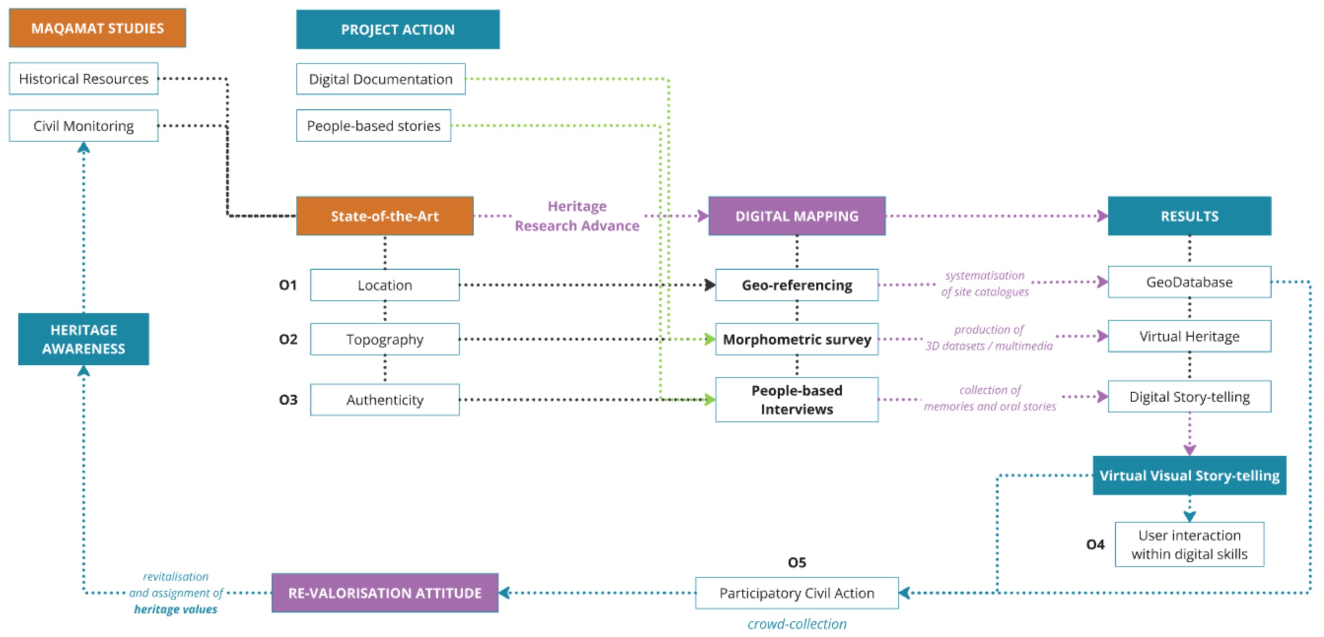
O1. Systematising the international mapping experience of maqamat sites in terms of “geo-localisation” and uniformed infographics related to geo-mapping. It involves the collection of a catalogue of studies and research (mainly conducted in the 20th century) constituting the state of the art, recording the identified sites in an up-to-date mapping system that allows them to be related to the present topography of the social and landscape context.
O2. Integrate geo-mapping with digital documentation to produce 3D datasets and multimedia documentation for each site. The survey is meant at the dual architectural and landscape scale and focused on a morphometric data modelling target. Geo-localisation from survey data is included and exploited for integrating the systematic mapping of O1.
O3. Collect memories and oral knowledge on the sites, including untold social narratives which can arise from the local communities historically and spiritually linked to the heritage sites. This action is based on the authenticity and originality of information related to heritage sites from indigenous experiences and practices, towards the transmission of associated values. The objective is supported by the development of story-telling tools to be connected to the visual interaction with the virtual 3D datasets, to constitute meaningful mnemonic mediums in composing the narrative structure.
O4. Extend the application of digital skills in the translation and/or production of 3D models and story-telling, supporting the impact of interactive visualisation, communication and interaction with users enhanced by the digital sphere.
O5. Encourage the participation of the user community in the overall action of mapping and awareness of the route of sites and their conservation framework. In this sense, research communication can be oriented to activate and facilitate a crowd-collection from community-based testimonies of the existence, location and information of sites, to be further investigated with the reapplication of the digital survey approach and extending the digital monitoring action.
1.2 Maqam: the structure of a “spiritual shrine” shaped within religion, society and landscape
The architectural typology of the maqam [pl. maqamat] as a shrine consists of a genuine expression of the peasant inter-religious tradition in the Levant, including a more detailed network system of hundreds of sites in the Holy Land. Maqamat express a spiritual transcendence in the conformity of their sites, integrating visual and structural features enclosed in centuries of stratification by both community and landscape. In this sense, their nature is reflected by the different regional religions, which have contributed to their origin and shared their use as shrines over the past centuries3.
Different configurations of maqam can be observed from existing case studies (Petersen, 2018), varying in extension and complexity of articulation of the functional environments and architectural components, from single-room structures to wider complexes for hosting visitors and additional uses.
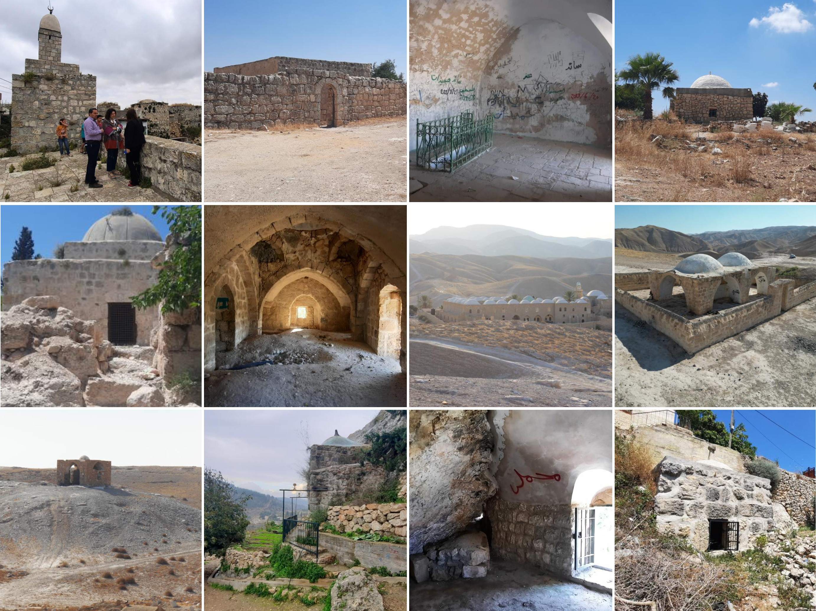
R. De Marco, 2022-2024
Figure 2 Overview of maqamat sites in the project area, presenting the variety of configurations and design patterns
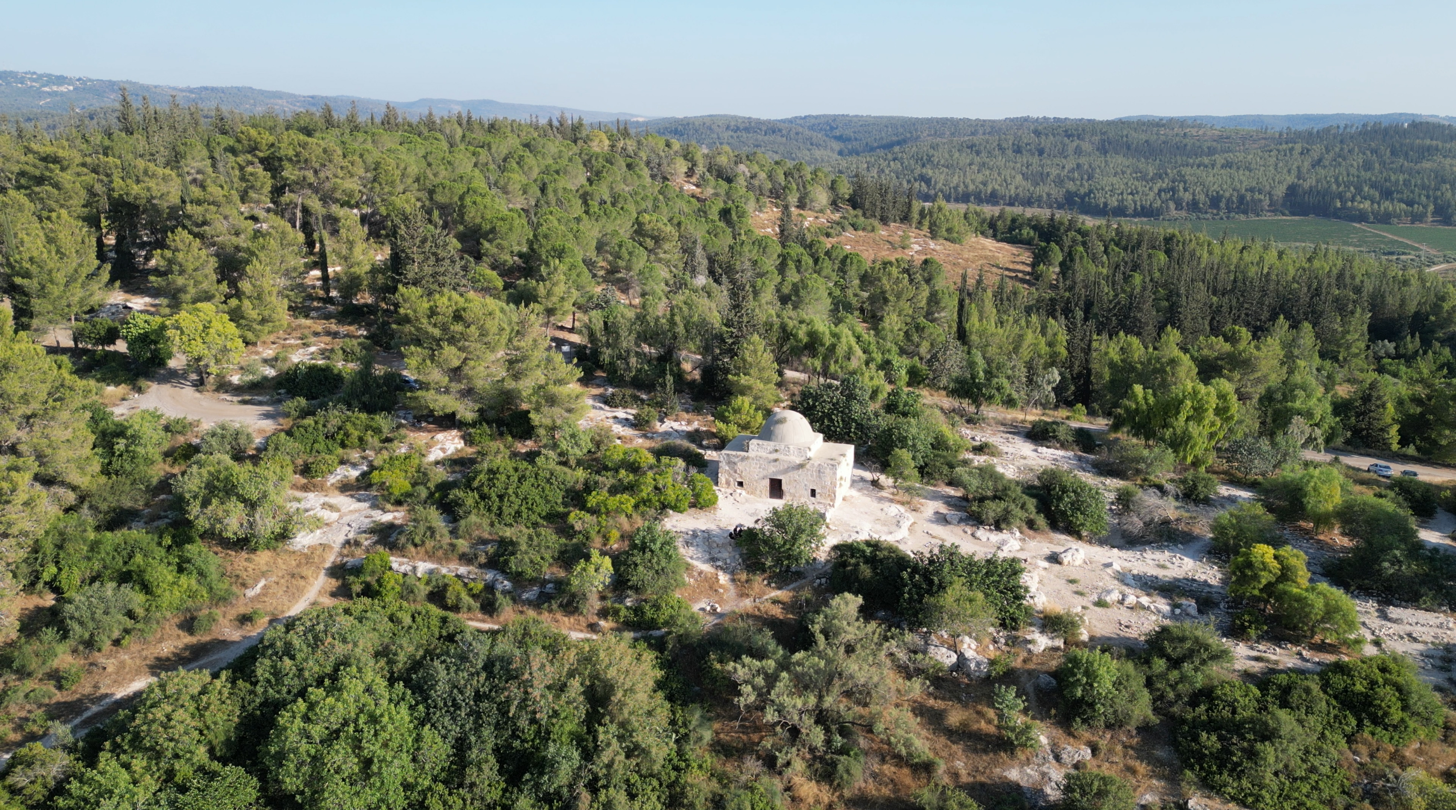
In a comprehensive analysis, the main typological architectural components of a maqam consist of: a main squared room (around 5-10 meters for each side), usually realised in stone masonry; a dome (qubba), over the main room; a doorway; a mihrab and/or niches (taqa) for offerings (optional); a tomb, cenotaph or grave (optional); an external portico (riwaq) on the main front (optional); additional rooms for other uses (i.e., praywe, storage...); cisterns, wells, ovens, courtyards, caravanserai (khan) or other structures related to their use for the hospitality of pilgrims and travellers; in some cases, a cemetery is developed surrounding the site. Within the regional Architectural Heritage, maqamat are recognised regarding their role as territorial markers, due to their traditional position on hilltops or topographic landmarks, which tended to assume visibility and functionality of their architectural space.
The symbolisation of typological features has been consolidated particularly on morphological and geometrical components, related to the architectural system and the surrounding border area of the sites. One feature is the characteristic covering dome, symbolically recognised to evoke the divine celestial sphere, with varying chromatic characterisations according to the specific religious faith4. Another feature of religious connotation is the presence of a cenotaph, determining the sacredness of the site5. For centuries, the visuality of maqamat as domed shrines has been predominantly related to Islam (McCown, 1923), even if many sites have never been documented in history as ascribed to any religious use. Instead, precisely in the function of the social pre-eminence constituted by leaders and ancestors in the peasant Palestinian kinship, the wide diffusion of maqamat dedicated to such figures traces the use of the architectural typology in terms of “social spirituality”.
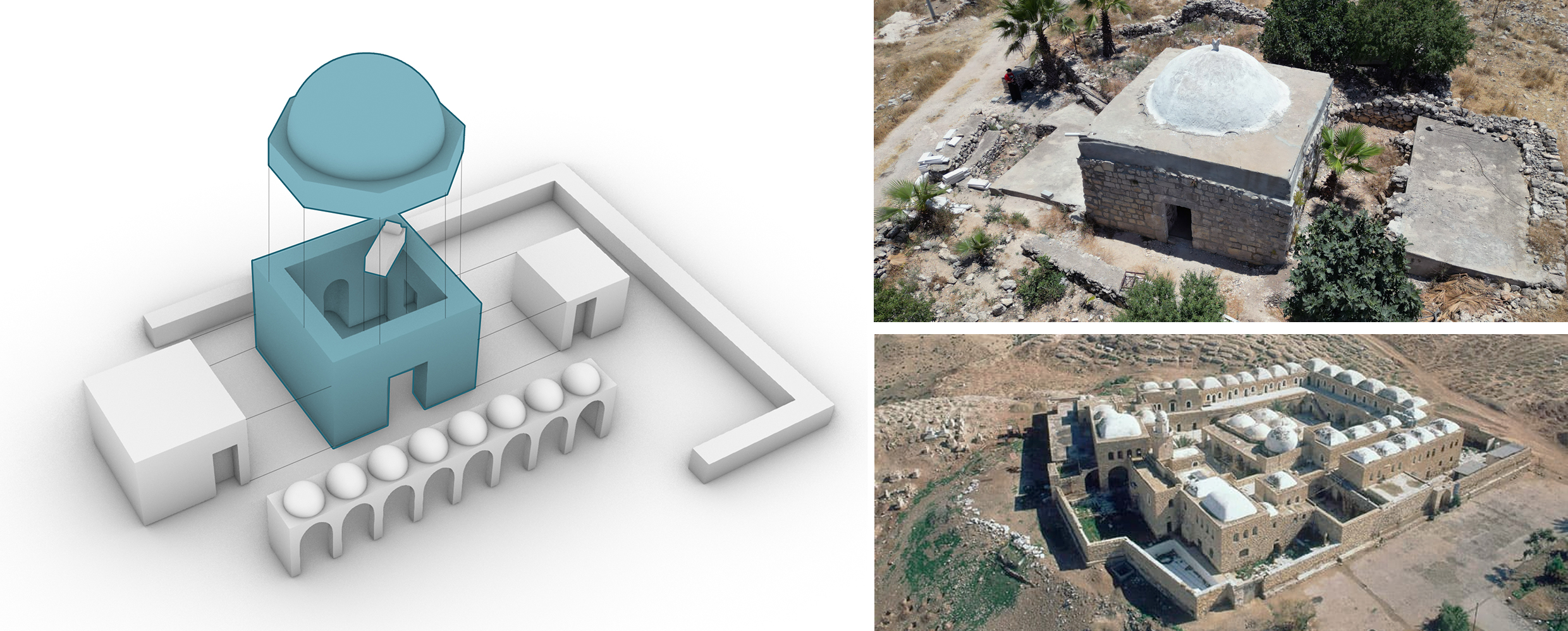
Western knowledge tends to associate the maqam typology with a mausoleum or funerary architecture. Although some sites show the presence of a tomb, its role is mainly commemorative and does not mark the real presence of a burial place or other relics. The iconographic association of the maqam, a squared structure surmounted by a dome, has been assumed in the centuries as a visual geometric persistence in the landscape, marking the land with a memorial sign associated with exceptional historical figures, both social and religious. Many of the most famous maqamat are dedicated to prophets (‘nabi’), but along with them other major ones are related to sheikhs, spiritual leaders, village founders or other ancestors6, women (“sitt”), martyrs or Sufi philosophers. Often, the coexistence of inter-community narratives, or different historical interpretations, also associates their dedication to other religious figures (e.g. rabbis) or common prophets with different translations of names (Meri, 2002).
Practices related to maqamat range across religious and social traditions and rituals (Lecoquierre, 2019). The spirituality evoked by the typology has led to its prevalent use for institutional prayer, reinforced by the introduction of architectural elements such as mihrabs, niches and altars. With more popular resonance, the votive use is also maintained in the presence of a cenotaph, evoking reverential contemplation. At the same time, the maqam is linked to rituals of protection from evil spirits in the more folkloristic tradition of the region (Conder, 1877), linking the figure to whom the maqam is dedicated to the protective role of the community and the village, concerning which the maqam is usually placed at the entrance perimeter. Moreover, its site near water resources, such as springs or wells, also links women and social gender traditions to the care and preservation of these architectural sites.
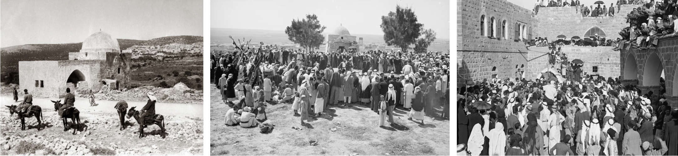
Mary Evans Picture Library/Pump Park Photography, 1890; Matson Photo Service, 1943
Figure 4. Religious celebrations and social events around maqamat
The maqamat presents a double dimension of both local representation of the identity of their host villages, tying in with the specific local social dimension, and of significance in their overall territorial route, as a goal of achievement of the travel and celebration. In this case, festival traditions are associated with the sites, where traditionally families and travellers would gather and stay for periods of months, celebrating the spiritual dedication of the maqam while developing social relations and exchange. In both cases, with the disappearance of historical villages (Khalidi, 1992) and the suppression of festivals in anti-nationalist events in the Levant during the 20th century, the presence of the maqamat and the role played by their visuality in the landscape allows for spontaneous maintenance of interest and research on their linked cultural legacy (Bowman, 1993).
The diversification within the heritage ecosystem of the maqamat allows to understand how their assumption as religious typology originates research interest in them, but it can’t be the determining factor in guiding a systematic study around their heritage. Maqamat identify places of popular devotion, and for this reason, they have been designed over time on popular architectural design patterns related to different expressions of spiritual value, which need to be linked in the dynamics of historical, social, political and communal events to ensure a complete knowledge on their cultural significance.
2. Materials an methods
The research applied three methodological phases related to objectives O1, O2 and O3. Their integration enabled a focus on documenting the heritage of the sites at the territorial, architectural and community scales, visualising in a comprehensive study the processes of characterisation of the architectural typology and transformation in the transmission of the related social legacy.
These processes were evaluated in terms of digital data processing, creation and management (O4), working towards the development of visual properties and involvement mechanisms functional to the goals of community participation and its contribution to impact and future development in the citizen science dimension (O5).
2.1 Systematic geo-localisation and geo-mapping of maqamat
Collecting and systematising the available information from literature resources was conducted as a preliminary phase, identifying and mapping maqamat sites with a comprehensive literature approach. In particular, during the 20th century, numerous studies and travel reports have been produced on the study of maqamat sites: many are notebooks and diaries of travellers or pilgrims, noting sites encountered along their route. In other cases, the documentation is properly structured on the specific search for the maqam typology, and the mapping and information about the sites have been structured with a scientific approach. The work by Tawfik Canaan (Canaan, 1927), for example, offers one of the most comprehensive records of regional maqamat.
Other similar studies include the work of Jaussen (1927), a systematic study of the shrines in the city of Nablus, and the works by Piccirillo (1981-2008), in terms of recent biblical archaeology7.
A parallel consideration concerns the collection of surveys and maps produced during the British Mandate from the late 19th century, developed as a colonial survey campaign. The survey was oriented on land and resource estimation, without specific attention to the architectural vernacular heritage. However, maqamat were identified due to their assumption as key points of trigonometrical mapping, for their topographical relevance as territorial markers. This property has allowed a diffused availability of their locations, as developed in the ‘Survey of Western Palestine’ by the Palestinian Exploration Fund8. Subsequent Anglo-Saxon studies are also part of this perspective, where it is possible to note a particular influence in religious terms in the categorisation of sites9.
Considering more recent sources, it is possible to include travelling reports and systematic actions conducted in the last 20 years by citizens, travellers and bloggers, encountering such artefacts through targeted visits, excursions or trekking activities. The report of sites’ locations developed by the blogger Boris Fenus (2013-2019) and made available in a public open Google Map is one of these main sources. Their notes as well as the public diffusion of photos and videos on the sites contribute as a key part to the documentation phenomena, both for the recent temporal proximity and for the type of data shared, as native digital photographic data usually from smartphones or other georeferencing devices.
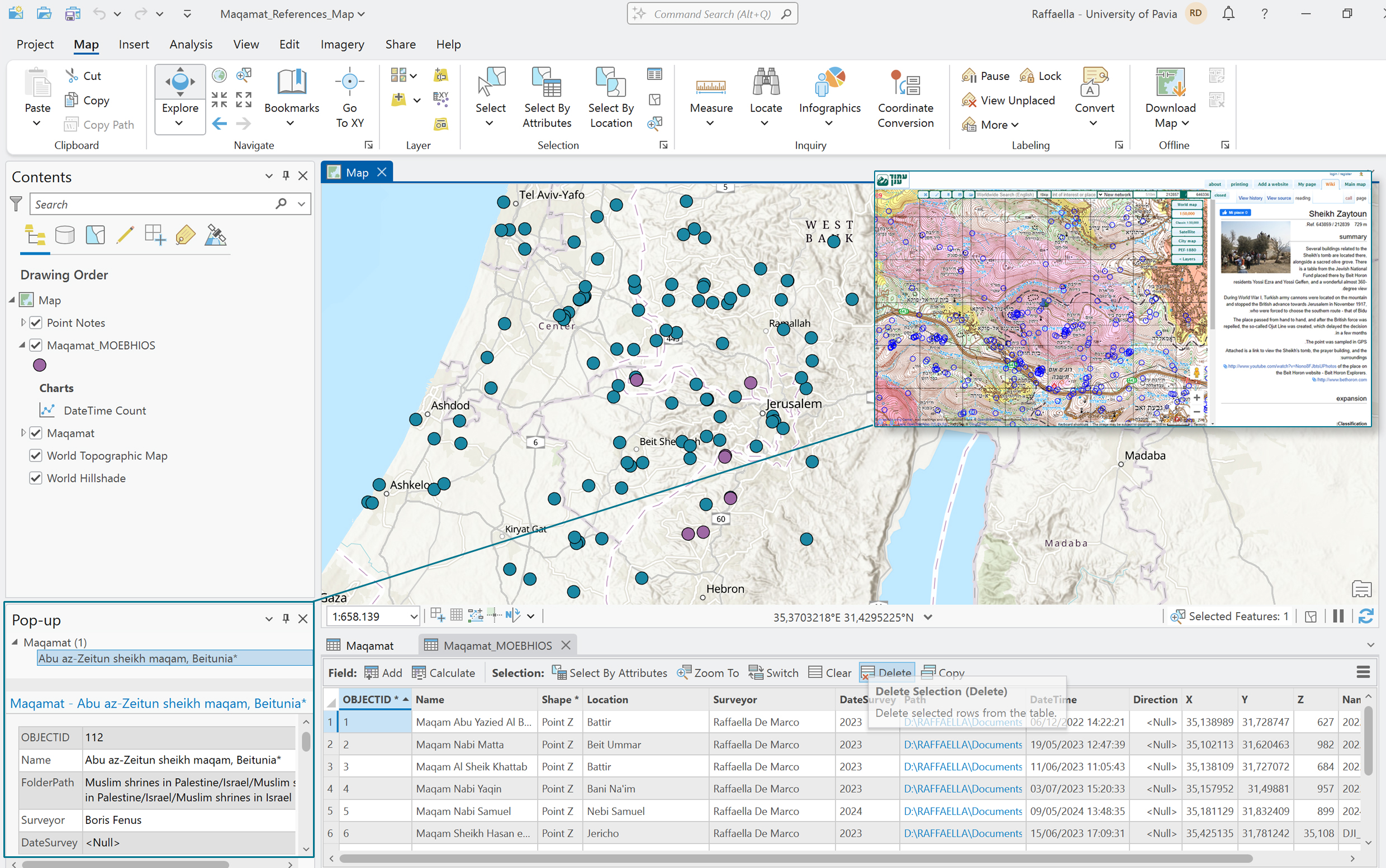
Collecting this accessible repertoire of data and other state-of-the-art contents, the preliminary research action concerned the structuring of a digital GeoDatabase, implemented through the ArcGIS service platform. The action focused on both the collection of geo-localised information and the development of an infographic representation optimised for displaying and consulting the available geo-data. Regarding recent digital sources (e.g. itineraries and public user maps developed through Google Maps or OpenStreet view), it was possible to convert the web data into KML geospatial datasets and import them into the project GeoDatabase preserving original positions and attributes. In the case of literature (essays and historical maps), the geo-mapping was conducted manually by identifying the estimated locations (with the support of satellite map services) and compiling the site record with available information. Finally, sites documented through the project action between 2022 and 2024 (some of which are not present in any historical reference) were integrated.
Map layers were structured by digitised sources, standardising the Attribute Tables in terms of relevant data classes (site-specific name, village/area, surveyor, year, GPS location). In addition, other available textual and graphical information was structured within the GeoDatabase. By enabling the display of pop-ups, data and references to third links were structured for direct consultation.
2.2 On-site digital documentation and 3D morphometric survey
The research activity involved direct inspection of maqam sites for on-site documentation and digital surveys. The pilot documentation campaign, ongoing and still expanding, was aimed to identify targeted sites on: (i) preliminary identification of maqamat from documentation sources (consulting the GeoDatabase inputs); (ii) discovery and mapping of maqamat as parts or in proximity of heritage complexes during research visits; (iii) identification of neglected sites indicated by representatives of communities, institutions, local academies and other stakeholders or local users.
Concentrating the pilot action of the on-site documentation in the area between Jerusalem, Bethlehem and Hebron, the specific conditions of infrastructures and geo-political management, as well as the military sensitivity of many areas, conditioned the adoption of a digital survey strategy with predominantly multi-instrumental and multi-data 3D photogrammetric application, including the testing of videogrammetry10. In particular, three levels of documentation were identified concerning the morphological conformation of the sites: (i) landscape area and architectural complex, documented with ultra-light UAVs photo and video acquisition integrated with GPS reference; (ii) architectural exteriors integrated with camera-based capturing and 360° cameras record for photos and videos, including GPS reference from a smart device; (iii) architectural interiors with camera-based and 360° cameras record, according to accessibility of spaces.
The collection of material was structured for processing the data by 3D photogrammetry, ensuring visual coverage and photos overlapping to compute 3D morphometric datasets from the photographic and video material.
The adopted photographic instruments have been selected considering feasibility and smart application by the survey operator, to reduce the risk of incurring the on-site application limits for professional instrumentation (e.g. laser scanners, UAS and GPS repeaters). In the case of the UAV, a DJI Mavic Mini 3 model has been applied, ensuring capturing qualities of 48MP: 8064×6048 pixels for photos and 4K: 3840×2160 pixels for videos. All records included geo-positioning properties measured through the integrated GPS sensor. Considering the morphology of the sites and the distance of acquisition (around 20m from the maqam surfaces), the resolution at ground level (GSD) was estimated at around 1.5 cm/pixel, ensuring the visibility of architectural features for the 3D processing.
Despite the choice as an ultra-light UAV11, flight limits related to the heritage sites’ areas were diffusely incurred: in such cases, the photogrammetric campaign was developed through terrestrial photo cameras and datasets were referenced by acquiring selected photos joint to key points with GPS reference from a smartphone device or an RTK antenna associated with a 360° camera. The terrestrial camera reflex applied was a NIKON D3300 camera, 24.3 MP: 6000 x 4000 pixels. The 360° camera was a RICOH Theta Z1, 23MP: 6720 x 3360 for photos and 4K: 3840×1920 for videos.
The processing of the photographic and video data, oriented, calibrated and aligned, allowed the morphometric reconstruction of datasets on the visible surfaces documented in each site. The processed 3D point clouds, including RGB colourimetric data, defined the availability of geometric databases for each site, providing useful data on the morphology of sites and for analysing geometrical components (elements, decorations, additions, and other details). The availability of the point cloud datasets subsequently made it possible to develop and optimise mesh surfaces combined with photographic textures, for obtaining 3D Virtual Models useful for dissemination and interaction with users, compatible with web visualisation and design opportunities to support the user experience.
2.3 Collection of oral memories and community-based practices
Parallel to the on-site visits and the survey for morphometric documentation, a campaign of interviews and collection of social information on the sites was undertaken to document related social and historical memories connected to the places and the maqam spiritual practices. The interviews included members of the local community in the maqam area, associations or institutions for heritage management (i.e., municipalities, heritage conservation centres, local eco-museums), as well as villages’ residents, heritage keepers, local visitors and other profiles linked to the living reality of the site of the maqam and custodians of stories and memories related to it.
This documentation phase, in addition to being the most delicate in terms of social ethics, needed the establishment of a mechanism of rapport with the interviewed profiles, encouraging them to share personal perspectives of memory related to the maqamat. It was also the most time-distributed process, related to the ability to reach out to multiple characters from the maqam context diverse in terms of gender, generation, occupation and social role, for ensuring a multi-choral interpretation of the perception of the maqam from the local community. The choice of key informants followed a selection based on the long-term awareness of the site and the context, especially since before 1948 and the large migration flows of communities in the area. In particular, members of village founding families were involved. In addition, personnel qualified in local historical and architectural heritage participated in the interviews, such as local professional technicians, managers of local museums and scholars. Finally, regional heritage architects and students, often from the same villages/settlements as the sites, participated in the reporting and collection of information on the maqamat.
Due to the specific diversity of each maqam and their local socio-territorial contexts, the interviews were conducted by adapting questions to two main focuses: (i) information and clarification of meaning about the maqam’s spaces and architectural elements, (ii) retrieval of personal/collective memories related to the social dimension taking place around the maqam and the context of its site. From the perspective of the development of story-telling outputs associated with 3D Virtual Heritage products, relationships between collected memories and architectural environments/elements were identified and where necessary specifically requested during interviews. The interviews were conducted in a different time phase from the 3D digital documentation of the sites, following the availability of access to the maqamat and the meetings with informants. In some cases, the visualisation of photographic and video data facilitated the interviewees in their narration, if this didn’t take place directly on the site.
The personal perspectives gathered during the interviews expressed a choral variety of untold stories and details related to the maqamat and their involved practices. Perspectives from childhood pasts, from professional critical designers and municipal and regional managers included information related to the change of traditional ancestors’ celebrations, peasants’ perceptions, and preservation attitudes from the local communities, integrated with reports of recent events concerning land practices and the relationship with surrounding settlement policies.
Personal stories and perspectives of narration related to the sites were collected as written notes or oral interviews, contributing to the integration of the corpus of site documentation as well as to the interpretation of architectural design features or historical components highlighted by the morphometric reconstruction of architectural artefacts.
The story collected on the maqamat forcibly encountered critical issues during the construction of the narrative discourse in the interview, including temporal disjunctions to affect the construction of the overall sense of place analysis. In this sense, the narratives were structured from the information collected during the interviews according to the story-telling semiotics (Ferraro, 2020), focusing the start of the story on the component of “absence” (of the maqam, people, practices) linked to the personal memories of the site, intertwined with events related to the family, occupation or other encounters. This framework triggered the sharing of contextualisation of the maqam as a concrete place of relationship with the subject of the narrative. The goal consisted of a critical construct of “identity” in the transfiguration from the interviewed subject to the maqam itself, through the subject-maqam interaction in terms of signs and actions linked or reconstructed as visual perception of the architectural dimension of heritage.
The methodological structure applied was in this sense guided in terms of an oral interview, reflecting narrative construction and identifying parallelism between the story-telling information and the features of geolocation, architectural features, use and conservation collected within the on-site survey and geo-mapping activities.
3. Results
The collected data were processed through visual and info-graphic approaches to develop digital visualisation and communication results corresponding to the objectives of geo-mapping, 3D visualisation and digital storytelling. The opportunity for interaction between the different products was exploited to design a narrative web platform on the maqamat heritage, to collect and orient heritage presentations and to promote civil participation in the monitoring action.
3.1 Production of 3D reality-based models and design of Virtual Heritage collections in Web Repositories
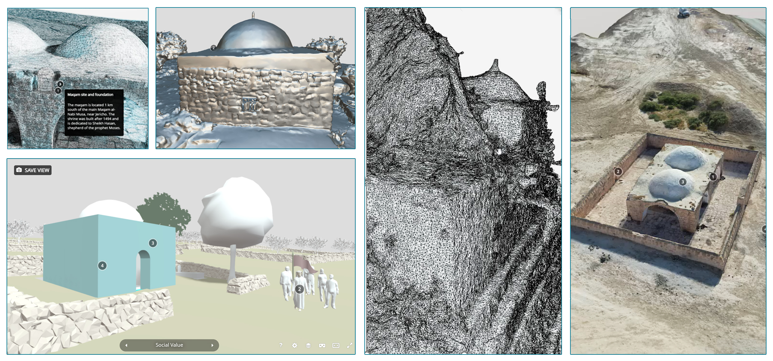
The photo and video material collected from the on-site digital surveys was post-produced through 3D digital photogrammetry: the process, based on analysing the camera parameters and photo perspective alignment, reconstructed the position of the pixels in a three-dimensional space, corresponding to each pixel a point and visualising a 3D point cloud dataset on the architectural scene in its complexity. A further triangulation process generated polygonal surface meshes, developing 3D mesh models completed with the projection of the photographic texture.
The reliability of the collected datasets was ensured at the centimetre scale according to the survey parameters, and it constituted a solution for representing the geometric characteristics of each maqam and the topography surrounding the site. This mimetic representation approach constituted the characterisation of the digital survey results as reality-based models, with reliable geometric details, available for implementation as digital twins. The versatility of optimising the generated mesh surfaces and converting and exporting them to open formats allowed their web-based application in Open Repositories. The 3D models of the maqamat were uploaded on the SketchFab platform, constituting a specific collection of items, and made available for public viewing and interaction as 3D Virtual Heritage. Specifically, two options of implementation were available for the users’ experience: (i) the informatisation of the models for dissemination, by inserting textual, image or multimedia information and designing their accessibility through pop-ups directly queried by navigating the model; (ii) the opportunity to view the 3D models in VR (Virtual Reality), orbiting the model directly from display; (iii) the visualisation in AR (Augmented Reality), with the opportunity of connecting AR visors for immersive experience, or projecting the models in the real space from a personal display (smartphone, tablet).
3.2 Update and crowd-based enrichment of the project monitoring map on maqamat
The research action adopted an integrated documentation approach in the holistic structuring of the maqamat material, disposing of the integration between the different information formats in the implementation of the GeoDatabase.
The GeoDatabase developed on the maqamat mapping is based on the geo-localisation of sites to coordinate overall information reporting the characteristics of sites from the spatial to the architectural scale. The data are collected in a layer of the overall system, characterising a knowledge class for the historical Architectural Heritage widespread in the region. Concerning the maqamat, the information has been structured to ensure the identification of the monument’s relevance in the religious and social context, including its dating and the available historical notes that can contribute in a complementary way to the contextualisation of the site in historical memory.
R. De Marco, 2024
Figure 7 GeoDatabase and integrated information from project action (violet) and reference resources (in blue), including pop-up visualisation and external connection
The GeoDatabase is interactive and responsive between the desktop version and its online web sharing, allowing for interfacing and self-updating changes and keeping the mapping always visible and available through ArcGIS services. In addition, a questionnaire was developed through ArcGIS Survey123 to guide a crowd-sourcing action over time to contribute to and extend the mapping and monitoring of maqamat sites. Through the suite’s application, a questionnaire was specially designed and made accessible online to report additional sites corresponding to the maqam typology. The user can geo-localise the location of the new maqam and fill in the fields corresponding to the basic information needed for the integration into the GeoDatabase. In addition, the user can contribute with more knowledge information on the maqam, by sharing photos and videos or by releasing an audio recording to share a direct interview. The questionnaire will be available in several regional languages, and its results interface directly with the project’s GeoDatabase reference system, allowing reported sites to be referenced to the general map, and proceed to verification, integration and validation for adding new records to the database.
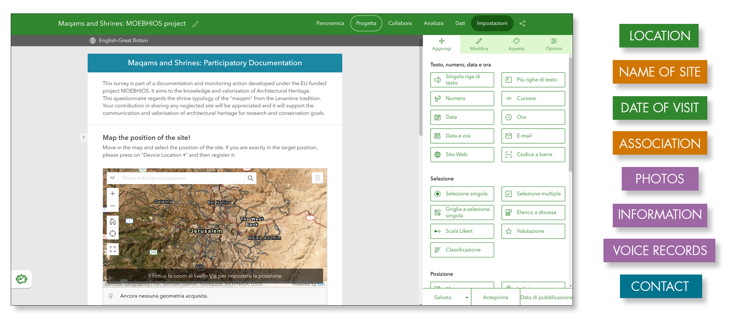
This result encourages a systematic mapping and monitoring action among the main sources related to the maqamat regional research, as well as including the prospect of growth and enrichment over time of the number of known sites through the contribution of users and citizens, systemising possible further actions from the civil society.
3.3 The design of a narrative format from digital visualisation
The results produced in terms of digital documentation constituted a fundamental milestone in the definition of an overall mapping, surveying and story-telling strategy, however, they still consist of sectorial and specialised information, with complexities in the dissemination to a broader public.
The design of a narrative solution was aimed to disseminate knowledge about the maqam heritage by exploiting the visuality and representation potential of the documentation data, to integrate it into the construction of a story-telling service based on users’ interaction and public experience. The ArcGIS StoryMap application optimised the reuse of survey information, data from the GeoDatabase and the Virtual Heritage collection. The materials were interfaced through a private server to be published in StoryMap, where at the same time a web design visualisation was structured, exploiting contents in both static and interactive sections12.
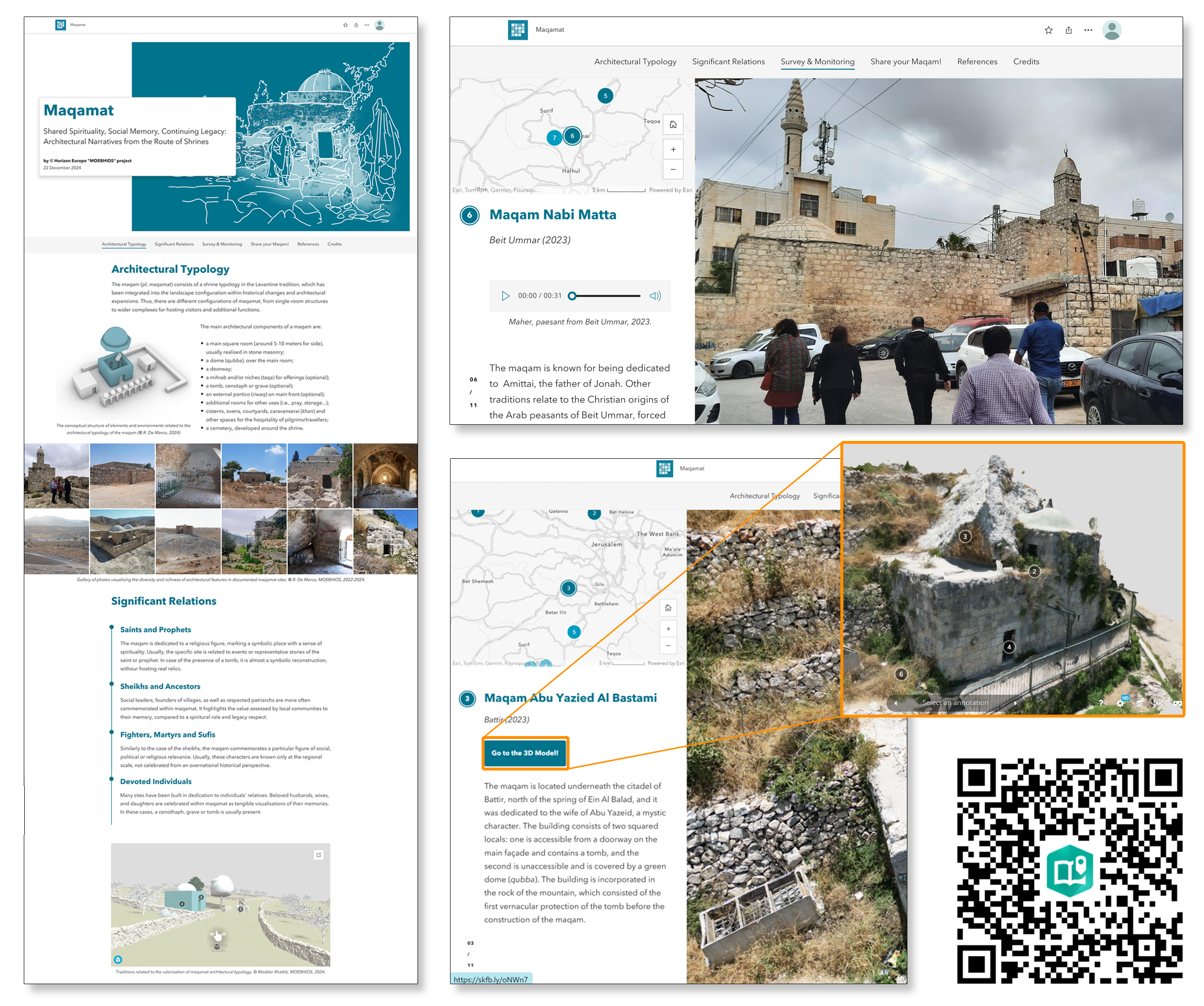
The resulting StoryMap structures the narrative discourse on maqamat in four sections. First, it introduces the architectural typology of the maqam and orients around its main elements, supporting the learning visualisation with photo galleries produced from the survey data, where each site is named and referenced. In the second section, knowledge about the main features characteristic of the maqamat heritage, in terms of historical, religious and social relevance, is given concisely, providing users through the narration with all the basic information necessary for the identification and monitoring of the sites. In addition to the texts, 3D virtual models developed in conceptual style were integrated, providing interactive visual scenes related to the traditions and values of each maqam within 3D features, notes, videos and other insights.
In the third section, more technical information on surveying and monitoring actions is provided, enhancing the visuality of contents to facilitate their understanding. Public levels of mapping are included and directly usable, as well as comparative slideshows between dated photos from on-site conservation monitoring. The section includes a guided tour designed on the principle of “scrolly-telling”: it is possible to scroll the story through page-flux and animations, explore the list of documented sites, learn their main stories and interact with the multimedia content related to each maqam. Incorporated links connect to 3D models available on SketchFab for visualisation, and audio recordings processed with AI from the interviews contribute within a first-person narration, sharing personal stories to raise awareness of significant events in the history of maqamat.
Concluding, the fourth section contains the crowd-sourcing questionnaire for the documentation of the maqamat, directly accessible at the end of the narration. The story is completed with the main bibliographical references and the credits to the research project.
The StoryMap “Maqamat. Shared Spirituality, Social Memory, Continuing Legacy: Architectural Narratives from the Route of Shrines” is under a dissemination campaign, including dedicated distribution through the project channels, institutions and partners, to be accessed via the web link or QR code, to support public participation in the initiative.
4. Conclusions
The research highlights the cultural and spiritual significance of maqamat, positioning them as core heritage landmarks in the Levantine and tangible visualisations of signs from religion, social identity, and collective memory. By employing a multidisciplinary methodology, including a comprehensive GeoDatabase mapping, digital documentation and the collection of oral stories, the research presents a dynamic and replicable framework for re-valorising maqamat. The resulting outputs, exemplified in the digital narration, offer new pathways to reconnect knowledge around these sacred sites and communicate it to both local communities and a broader international audience.
In addressing RQ1, the findings highlight that a successful re-valorisation attitude must transcend the clustering of maqamat within polarized political or religious narratives. By focusing on immersive narratives that evoke introspection and spiritual continuity, the maqamat can be repositioned as unifying symbols that encourage an inclusive connection to the Levantine cultural landscape. This resonates with a wider experience and campaign on Mediterranean religious heritage and its recovery efforts in terms of inner spirituality, where pilgrimage routes, monasteries and minor vernacular shrines have been revitalized through storytelling to reclaim local identities and histories.
The spiritual dimension of the maqamat is reflected in the in-depth analysis of attributes that can communicate the cultural meaning of the sites through the regional and social transformations imprinted on the contexts. The visuality and understanding of the architectural components, made possible by the integration of the survey data and the story-telling structure, is linked in the communication from the StoryMap to key attributes of tradition, attachment, cosmologies, practices and embodiment of figures/events, in addition to the canonical attributes of religion and belief. In this way, the value of “spirituality” wants to be re-proposed within the cultural evolution around the historical region, adapting to the contemporary geopolitical context and conforming as a meaning of cultural “union” rather than “fragmentation”.
Regarding RQ2, the research affirms that sustainable approaches to documenting maqamat must prioritize inclusivity and adaptability. The GeoDatabase serves as both a repository and a generative narrative platform that evolves through community contributions, fostering a “citizen science” approach to heritage preservation. Inviting displaced individuals to share untold stories can strengthen the narrative structure, creating a shared cultural memory that reconnects the bonds between the sites and their heritage keepers.
The research also addresses the challenges of re-functionalisation and the resulting detachment of sites from their legacy stories. Altering the perception of maqamat sites, without ensuring both their material and immaterial conservation in an authentic approach, can lead the local community to disregard its architectural heritage. Virtual Heritage galleries and interactive digital exhibits can intervene in this connection, reaching the local community in a virtual dimension, and presenting maqamat as a still present and living heritage. The parameterisation of the GeoDatabase and its multimedia integration supports flexible queries and dynamic assignment of values, offering an evolving, modular system that enriches sustainable heritage practices and underscores the potential of digital storytelling to preserve cultural memory over time.

