


Serviços Personalizados
Journal
Artigo
 Inglês (pdf)
 Artigo em XML
 Referências do artigo
 Enviar este artigo por email
Indicadores
-
 Citado por SciELO
 -
 Acessos
Links relacionados
-
 Similares em
SciELO
Similares em
SciELO
Compartilhar

 Permalink
Finisterra - Revista Portuguesa de Geografia
versão impressa ISSN 0430-5027
Finisterra no.99 Lisboa jun. 2015
https://doi.org/10.18055/Finis4119
ARTIGO ORIGINAL
Airport planning process. The case of the new Lisbon airport
O processo de planeamento aeroportuário. O caso do novo aeroporto de Lisboa
Processus de Planification aéroportuaire. Le cas du nouvel aéroport de Lisbonne.
João de Abreu e Silva1; Jorge Gonçalves 1; Marcos D. F. Correia1; Susana Marreiros1
1Ceris, Department of Civil Engineering, Instituto Superior Técnico, Universidade de Lisboa, Portugal – joao.abreu.silva@tecnico.ulisboa.pt; jorgemgoncalves@tecnico.ulisboa.pt; marcosdfcorreia@tecnico.ulisboa.pt; susana.marreiros@ist.utl.pt
ABSTRACT
The main purpose of this article is to analyse the relationships between the planning process of the new Lisbon airport (NLA) and several planning instruments, both territorial (regional and local) and sectorial (transportation and road), during the numerous iterations in the NLA planning process. At the end of the 1960s, Portuguese authorities pondered the need of a new airport to replace the existing one at Portela. A number of locations were suggested during the planning process. Several of them were invalidated over time due to urban development or to the constraints imposed by environmental laws. This paper analyses the various planning instruments in place from 1960 until 2010 and their relationship with the planning process of NLA. The airport relocation decision is not closed yet. The documents drafted in the 1960s and 1970s reflect the dominant planning paradigms with a top-down approach strongly driven by the public administration. During the 1990s the procedure was resumed and in 2005, a new phase started with a strong influence of external stakeholders. However, due to the 2010 crisis the process was suspended. The regional planning of the last decades never revealed the ability to drive the NLA process. Indeed, the decisions concerning the airport relocation have strongly influenced the spatial planning process.
Keywords: New Lisbon Aiport (NLA), airport location process, regional planning, planning instruments, regional development.
RESUMO
O principal objectivo deste artigo é analisar a relação entre o processo de planeamento do novo aeroporto de Lisboa (NAL) e os vários instrumentos de planeamento, tanto territorial (regional e local) como sectorial (transportes e acessibilidades), durante as múltiplas interacções que ocorreram durante o processo. No final da década de 1960, as autoridades portuguesas ponderaram a necessidade de um novo aeroporto para substituir o existente (Portela). ao longo desse processo de planeamento foram propostos diversos locais. Vários deles foram invalidados devido ao crescimento urbano, ou a constrangimentos impostos pela legislação ambiental. Este artigo avalia os diversos instrumentos de gestão territorial em vigor entre 1960 e 2010 e a sua relação com o processo de planeamento do NLA. A decisão de localização do futuro aeroporto ainda não está fechada. Os documentos produzidos nas décadas 1960 e 1970 reflectem os paradigmas dominantes no planeamento com uma abordagem top-down, liderada pela administração pública. O processo foi retomado durante a década de 1990 e, em 2005, uma nova fase surgiu com o protagonismo de entidades não governamentais, que voltou a ser suspensa com a crise de 2010. O ordenamento do território das últimas décadas nunca revelou capacidade para conduzir o processo do NLA. Pelo contrário, as decisões de localização do aeroporto têm condicionado profundamente o processo de planeamento espacial.
Palavras-chave: Novo aeroporto de Lisboa (NAL), Processo de localização do aeroporto, planeamento regional, instrumentos de planeamento, desenvolvimento regional.
RESUME
On analyse les rapports qui ont existé entre la planification du nouvel aéroport de Lisbonne (NAL) et les divers outils de planification, tant territorial (régional et local) que sectoriel (transports et accessibilité), au cours des multiples interactions, qui ont eu lieu pendant le processus. Les autorités portugaises sentirent la nécessité d'un nouvel aéroport pour remplacer celui de Portela, dès la fin des années 60. Divers endroits furent successivement proposés. La croissance urbaine et la législation ambientale rendirent plusieurs d'entre eux caducs. On présente les divers outils de gestion territoriale qui ont été en vigueur de 1960 à 2010 et leur rapport avec les processus de planification du NAL. La décision de localisation finale est encore pendante. Les documents datant des décades 1960 et 1970 révèlent une gestion top-down, émanant de l'administration publique. Le processus se remit en marche au cours de la décennie 1990 et une nouvelle phase vit le jour en 2005, avec l'apparition d'entités non gouvernementales, mais la crise de 2010 y mit fin. La gestion du territoire n'a jamais été capable, au cours des dernières décennies, de mener à bonne fin le projet de NAL. Ce sont au contraire les successives décisions le concernant qui ont profondément conditionné les processus de planification spatiale de la région.
Mots clés: Nouvel aéroport de Lisbonne (NAL), processus de localisation de l'aéroport, planification régionale, outils de planification, développement régional.
I. INTRODUCTION
Once the decision to build an international airport is made, its planning and location choice processes are a very complex undertaking. These processes usually take a long time to develop and involve a multitude of stakeholders. The intervention of these stakeholders, both in its intensity and opinions/positions expressed, varies along the project maturation phase and can be related with the various contextual changes that occurred during this period. these changes comprehend technological changes, changes in environmental legislation that usually became more restrictive, changes in the processes and paradigms of territorial planning, to name but a few. One very relevant change is related with the way airports are seen today as compared with earlier decades. Airports are no longer seen just as public good transport interchange nodes, but rather profit oriented commercial ventures (Stevens et al., 2010). these changes of perspective raise the need to deal with several interdependent elements, e.g. the mechanisms by which an airport could impact on employment, population and economic growth; risk management; recognition of stakeholder expectations and motivations and management of shared decision processes between private and public sectors (Stevens et al., 2010).
Governments could either adopt a passive or active strategy in infrastructure provision; the former occurs when infrastructure provision follows the existence of serious bottlenecks, thus, infrastructure follows private investment (Rietveld, 1989). Conversely, the active strategy occurs when infrastructure is used as an engine of development, by leading private investment.
More recently, due to the publications of Aschauer (1989a; 1989b), more attention started to be paid to the role of infrastructures on economic development (Costa, 2002), and airports are important infrastructures. Since then several authors argued for and against the existence of positive effects of infrastructure provision on economic growth. for example; Rietveld (1989) argued that airport capacity itself does not have an influence on regional production; Munnell (1992) argued that investing on public infrastructure had a significant positive effect both on output and growth and more recently Pereira et al. (2005) found out that public sector investment in durable goods construction and equipment has a positive effect on long term economic performance, but not strong enough to repay public investment itself through future tax revenues.
Here we aim to focus solely on the location process of a major international airport. The justification of the need for a new airport, although a very relevant subject, is not treated here. This paper is organized as follows: On the following section we present some of the most relevant features of regional and urban theories; next, the evolution of the location choice process for the new Lisbon airport is presented, followed by the analysis of the interactions between spatial regional plans and airport related technical documents. The paper concludes with the analysis of the evolution of the LNA process in the light of the changes in the planning theory reviewed here.
II. URBAN AND REGIONAL PLANNING THEORY EVOLUTION
Besides the effects on economic growth, infrastructures and more specifically airport planning, urban and regional planning has also important connections both at regional and local planning levels. These connections go from the rationale behind the decision to build a new airport to the decisions about its location, its relation with other spatially based public policies and infrastructures and its relation with land use planning. Since regional development theories, urban planning theories and paradigms evolve through time, a long term planning process like the planning of the new Lisbon airport (NLA) will possibly be influenced by different planning paradigms and planning praxis.
1. Regional planning
Thus, it is important to make a brief review of the main regional development policies in the period when the NLA project came to maturity, not only to assess the decision's effects but mostly to understand the dominant development paradigms during this period.
Regional development appears in the political and academic speech through two fundamental points: how would the regional economic growth occur; and, given the fact that there are obvious development differences between regions, how can the interregional differences be minimised? The answers to these questions have varied throughout a large part of last century, especially in the post-war period. As for the first question, the emphasis was given to more economically marked visions; and regarding the second one the main concerns were political and social. Regional development theory emerged from different intellectual traditions: neoclassical trade and growth theories (Dawkins, 2003).
The political and technical answers to these demands have been broad and diverse (Nijkamp and Abreu, 2009) and sometimes coexisting and overlapping in time and with decisions:
a) growth pole theories, with a clear emphasis on a concentrated growth impulse in a few designated places or areas (Parr, 1999; Higgins et al., 1997);
b) supply side policy of a Keynesian nature with a pronounced interest in public spending in less privileged regions (Pike et al., 2006);
c) infrastructure policy with the aim of creating the necessary physical conditions (e.g., improvement of accessibility) in order to enhance the competitive capabilities of regions (Rietveld, 1989);
d) self-organising approach where regions are encouraged to work together on the basis of indigenous strength with a limited role of government (Johannisson, 2008);
e) superstructure policy in which regions are provided with favourable R&D conditions, educational facilities, knowledge centres and the like in order to create the conditions for a self-sustained development (Halkier, 2012).
The post-war Europe was marked by an urgent necessity of reconstruction, but also by an ambience of optimism, confidence and financial availability which generated the conditions for a unique economical and territorial dynamics. The scale of the intervention justified the state's dominant role, which was not original since it had identical influence on the economy and on the development of social welfare.
In this context, the regional development dominant paradigm was what can be called ‘the functionalist paradigm'. according to its massive public investments in certain areas – development areas – it would have the capacity to generate employment, real estate and demographic dynamics and also act as multipliers on the regional economic structure, and extend their effects to more remote surrounding areas. The location decision was centralised as were the levels of investment involved on traditional top-down logic. The infrastructure fulfilled a dual role of growth polariser and diffuser. Highly associated with these ideas were the theories of circular causality (Myrdal, 1957) and of centre-periphery (Friedmann e Weaver, 1979). They were also Keynesians views (Pike et al., 2006) in the sense to seek a better interregional redistribution.
The end of the 1970s brought with it the decline of fordism together with the energy crisis and, more concerning the economic crisis (Amin, 2008). The state role started to be contested and questioned, leading to new logics and paradigms of regional development policies. These were now more based on dynamics arising from local actors and resources, recognising however, that state intervention should continue to exist, in case of necessity, by supporting the creation of required conditions so that these dynamics can arise, as is the case of infrastructures (Halkier, 2012). These initiatives fall within what could be designated as the paradigm of territorial regional development with variations introduced by the intensification of the globalization and by the deepening of the sustainable development objectives.
2. Urban planning
At the local level, the 1960s saw the emergence of the systems approach to urban planning, what could be considered the high water mark of the modernistic optimism (Taylor, 1998).
Urban planning could be defined as a way of system control, enforcing the need to understand how cities worked in order to better plan them (Taylor, 1998). This approach also reinforced the connections between urban planning and transportation planning and was linked with the transportation/land use studies first highlighted by the Buchanan report. Altogether this represented a quantitative revolution in planning during the 1960s (Taylor, 1998).
During the 1970s the system based approach continued to dominate planning theory, but criticisms to it started to emerge. It was criticized for its abstractness and by the fact that it presented a false top-down view. The issues related with plan implementation and communication, as well as stakeholder management became important topics in planning theory. Also issues like sustainability, democratic control, social inequalities and equity issues and urban regeneration became important topics in planning theory, leading to some authors claiming that planning theory was being fragmented into diverse theories (Taylor, 1998).
III. NLA LOCATION CHOICE PROCESS
Lisbon has been the capital of Portugal for over 750 years, and its central location in the country has contributed to consolidate its status as the largest and most important city in Portugal. With the constant growth and promising development of aviation and after the use of a few landing fields, the Lisbon City Hall agreed upon the construction of a national airport. The current Lisbon airport opened in October 1942, in the area of Portela de Sacavém in the north eastern part of the city. the selection of this location was based on two main factors: proximity to the city centre and proximity to the riverside – the latter being a characteristic whose relevance faded throughout the subsequent years as seaplanes lost popularity over aeroplanes. the Portela Airport and the Cabo Ruivo Maritime Airport, 3 km apart from each other, coexisted for some years in Lisbon, linked by Avenida entre-aeroportos (in between airports), currently Avenida de Berlim.
The first discussions about the new Lisbon airport (NLA) are not as recent as they might seem: in 1958 the Ministry of Public works first mentioned the possibility of a new location for the capital's airport (Julião et al., 1988).
In 1969 the GNAL (new Lisbon airport Cabinet) was created as a temporary taskforce, with legal and administrative autonomy, to manage and coordinate all the activities related to the construction of the new airport, therefore, it was tasked with the execution of the preliminary location choice studies for the NLA.
The GNAL produced a document entitled Study for the location of the New Lisbon Airport (GNAL, 1972), which corroborated the decision already made on an earlier regional plan, the Director Plan for the Lisbon region (Ministério das Obras Públicas, 1964), by considering Rio Frio as the most suitable location for the NLA. During this process (GNAL, 1972) a multi-comparison with six different locations was made. All of the other options were discarded in favour of Rio Frio. the locations considered were: Fonte da Telha, was considered as the location with worst meteorological conditions, limited by natural and artificial constraints and located too close to Barreiro's industries (which would impact negatively on the visibility conditions); Portela de Sacavém, already occupied by the current airport, was conditioned by the strong urban occupation on the surrounding areas; Montijo and Alcochete, two different and close locations were discarded by identical reasons such as difficulty to construct, heavy environmental impacts and mainly because the Lisbon Port authority was strongly against the implementation of the airport due to future constraints to ship movements; Porto Alto site has limited visibility conditions, due to the frequency of dense fogs and it was too close to many military and civil aeronautical infra-structures in operation then. As the years went by, the Rio Frio option – and the whole NLA subject – lost relevance due to the oil crisis, the 1974 revolution and all the socio-economic issues that were associated with those two situations (Coutinho e Partidário, 2008). In the early 1980s, the NLA location studies were resumed, with several studies (ANA, 1982, DGTT, 1984, ANA, 1985) being made during that decade. It is interesting to verify that they did not show any connection to the previous studies and even planning instruments developed before. One might be tempted to conclude that the regime change that occurred in 1974, created the conditions to make tabula rasa of the previous planning instruments.
The report The Airport and the Metropolitan Area – Base Proposal (ANA, 1985) is one of the first to mention another location: Ota , an area in the northern bank of river Tagus, about 50 km from Lisbon. Although this option had been scarcely talked about since the 1960s, it did not gain emphasis until the mid-80s. The Ota location was deeply analysed and corroborated by several documents through the subsequent years (Gaspar, 1991, NAER, 1999a). NAER was a public company, owned by ANA – the national airport operator, tasked with the development and construction of the NLA. This location benefited from the fact that it was a military air base, thus reducing the value and need for expropriations.
In 1999, the Ota location came out as the best option in a comparison made with Rio Frio (NAER, 1999b). The reasons for this decision were related to several factors, namely: the creation of an airport in Rio Frio would create “non-minimisable, irreversible and non-compensable damages” to the environment; the Rio Frio runway would be incompatible with the military sites of Montijo and Alcochete; and Ota had larger building area (NAER, 1999b, Ca, 1999).
This choice was confirmed in the early 2000s, with the development of the reference Director Plan for the Conceptual Development of the airport for the Ota location (NAER, 2002). Despite the NLA location being already chosen and its director plan undergoing, the NLA construction was being delayed, mainly due to the project high estimated costs and the consequent controversy it generated.
In 2007, the process receded again, when a study funded by the Confederation of the Portuguese industry (CIP, 2007) challenged the Ota location in favour of a new one, Alcochete, on the southern bank of the Tagus River, a location discarded in 1972.
As time went by, the media coverage of the process about the NLA location increased and contributed for the discussion about the Alcochete option (Gonçalves and Marreiros, 2014). This sequence of events undermined the Ota option, previously considered as the definitive location.
The Portuguese government decided that this “new” option should be studied and compared with Ota. Therefore, LNEC (national Laboratory of Civil engineering) was mandated to develop a comparative analysis (LNEC, 2008) of the two locations, to identify which one would present a better cost benefit ratio. On one hand, Ota had better accessibility but it required heavy earthworks. On the other hand, Alcochete's overall costs were slightly lower despite being located in an environmentally sensitive area. Alcochete was considered as the best location for the NLA, situation that was officially confirmed by the government at the time (Conselho de Ministros, 2008a, Conselho de Ministros, 2008b).
Another option that had recently gained popularity was Portela+1. This alternative argued against the construction of a new airport and the closure of the Portela airport. Instead, it supported an apparently more cost effective option: the maintenance of Portela and the use of an airbase in the Lisbon Metropolitan area as a secondary airport for low-cost companies. Some of the debated locations for this secondary airport were Sintra, Alverca and Montijo (gonçalves and Marreiros, 2014).
IV. INTERACTION BETWEEN SPATIAL PLANS AND TECHNICAL PLANS
1. Until 1980
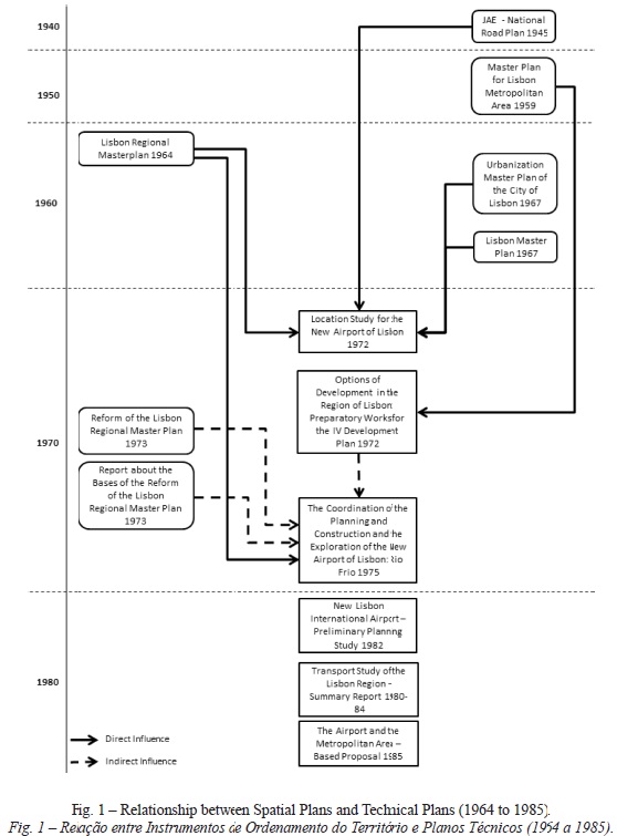
The first regional spatial plan applied to the region of Lisboa was the Director Plan for the Lisbon Region (Ministério das Obras Públicas, 1964) produced in the early 1960s. This document advocated that the future airport location would be in Rio Frio, north of the railway line between Pinhal novo and Pegões, and connected with the planned south freeway. This Plan does not justify the need for a new airport, it just defines its location and its relation with the land side transport infrastructures and proposed land uses.
In 1972, the Study for the Location of the New Lisbon Airport (GNAL, 1972), considered the NLA location according with the Director Plan for the Lisbon Region of 1960-65 (GNAL, 1972), the Urbanisation Master Plan of the City of Lisbon (from1967) (GNAL, 1972) and the general plans (of 1945) of the Jae (autonomous Board of the roads) (GNAL, 1972). it highlighted the need, along with the first regional Plan, to extend the south freeway to connect the airport perimeter with Lisbon by the Salazar Bridge (now 25th of April Bridge).
Also in 1972 a planning document named Options for Development in the Region Plan - Lisbon- Preparatory Works of IV Development Plan (CPRL, 1972) was elaborated. it had some references to the Urbanisation Master Plan of the City of Lisbon (elaborated in 1967 and at the time pending approval) (CPRL, 1972), to the Master Plan for Lisbon Metropolitan Area (produced in 1959, but not implemented) (CPRL, 1972) and to the 1960-65's Director Plan for the Lisbon Region (CPRL, 1972). These references were mainly limited to the transport infrastructures. Rio Frio was also the location mentioned for the NLA along with some unclear references to the requirement to link the airport with the primary roads through secondary roads. the airport accessibility and transport infrastructures issues are also heavily explored, their proposed alignments being quite similar to the ones proposed by Study for the Location of the New Lisbon Airport of 1972 (GNAL, 1972).
In 1973, two different drafts of a planned revision of the old Director Plan for the Lisbon region were put forward, the Reform of Director Plan for the Lisbon Region (Ministério das Obras Públicas, 1973a) and the Report on the Basis for the Revision of the Director Plan for the Lisbon Region (Ministério das Obras Públicas, 1973b). In both, coherent between themselves and with the previous plans and studies, Rio Frio was considered as the NLA location. these two documents mentioned the possible needs induced by the NLA construction: space enough to house 300,000 people, of which 170,000 on the ‘airport Community' (no further details about this); creation of an industrial zone nearby; a tourist centre; the necessity to define the connection from and to the airport by road and rail; and the construction of a bridge connecting the Montijo (Tagus south bank) to Beato (in Lisbon).
In 1975 a much more detailed study related to NLA, entitled The Coordination of the Planning and Construction and the Operation of the New Lisbon Airport – Rio Frio (STC, 1975) was produced. As the title shows, the location defined was still Rio Frio; it was a very complete plan with a large regional development component. it was coherent with the 1960's Director Plan for the Lisbon Region (Ministério das Obras Públicas, 1964) and with the drafts of its revision prepared in1973 (Ministério das Obras Públicas, 1973a, Ministério das Obras Públicas, 1973b). The more relevant similarities were related with the following aspects: recognising the need to constrain land use changes around the airport planned location due to the possible installation of commercial and industrial activities; the installation of an “airport Community”; and its connection with Lisbon by freeways (explicit reference to the south freeway) and railways.
This study also matched the already mentioned study of 1972 – Study for the Location of the New Lisbon Airport – (GNAL, 1972), on a highly focused point, the construction of an aerial urban terminal inside the city of Lisbon. It had also the particularity to refer to the lack of coordination and joint efforts between the different stakeholders involved in the NLA planning process.
2. Between 1980 and 2005
In the 1980s, three more studies were produced that were related with the NLA project: the New Lisbon International Airport – Preliminary Planning Study of 1982 (ANA, 1982); the Transport Study of the Region of Lisbon: Synthesis Report of 1980-84 (Dgtt, 1984); and The Airport and the Metropolitan Area – Base Proposal of 1985 (ANA, 1985). None of these had relevant references to the regional plans produced in the previous decades. the first one (ANA, 1982) is optimistic about the future economic impacts of the NLA (around Rio Frio) and proposes the allocation of space for urban and industrial uses, as well as for public facilities, associated with the new airport. The last study (ANA, 1985) focused on the effects in Portela Airport after its decommission due to the construction of the NLA. Figure 1 shows all the interactions between the different types of plans between 1964 and 1985.
From the first regional master plan made for Lisbon to the second one (CCDR-LVT, 2002) there is a time lapse of almost forty years. In 2002 the Regional Master Plan for the Lisbon Metropolitan Area (CCDR-LVT, 2002) – PROTAML was approved. It did not include any defined location for the NLA, but included references about the infrastructures that would serve the future airport such as: connection between the NLA, the region ports and Lisbon through freeways and high speed trains; construction of a third river Tagus' bridge; and the creation of spaces nearby NLA to develop commercial and industrial activities.
In this period Rio Frio is no longer considered the ideal location, being replaced by Ota. Personal opinions in form of books (Gaspar, 1991), articles and studies produced by several relevant stakeholders (e.g. Viegas, 2006, CIP, 2007) influenced the decision process with a variety of opinions, related with location options for the NLA, and about the relevance and pertinence of its construction (if Portela's expansion was a better choice, or even if the NLA construction was a good option).
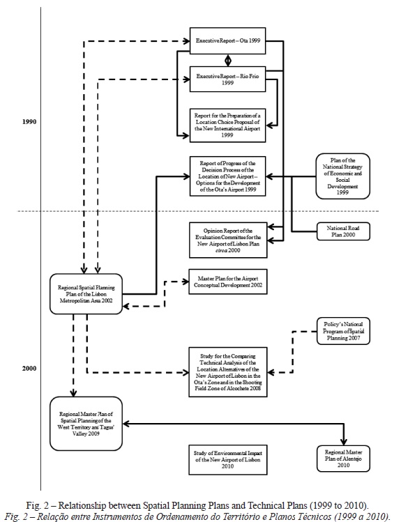
In 1999, a Decision Process of the New Airport Location - Options for Airport Development in Ota (NAER, 1999b) was published. In this document Ota was pointed out as the definitive location. This report made several references, not only to the PROTAML (NAER, 1999b) (which was at the time under development), but also to the Plan of the National Strategy of Economic and Social Development (PNEDES) of 1999 (NAER, 1999b) and to the 1985 National Road Plan (NAER, 1999b). these references consisted mainly in establishing some guidelines similar to the ones mentioned about the PROTAML (CCDR-LVT, 2002), linking the NLA to the railway system, potentiating the economic development on the NLA vicinity and the necessity to set up connections through freeways, not only to Lisbon, but also to important regional urban areas and facilities, like other cities and logistic platforms.
Before this report that set Ota as the chosen location, three studies were produced (all in 1999) to evaluate which of the proposed options was the best: Ota or Rio Frio. New International Airport -Report for the Preparation of a Location Proposal (NAER, 1999a) explored some technical studies (environmental impacts assessments) being the corollary of two interdependent studies, the Executive Report – Ota (NAER, 1999c) and the Executive Report – Rio Frio (NAER, 1999d).
Both executive reports comprise identical features of the future regional Plan (it appears that the regional planning process was not leading but mainly followed the location decisions proposed by the airport location technical studies). these features included: the proposed freeway connections; the high speed rail network; in the case of the Rio Frio location, the third bridge over the Tagus; and the expectation that the NLA would potentiate the regional economic and urban development of each location's surrounding areas. Both reports suggest the upgrading of all scale instruments of spatial Planning. Opinion Report of the Evaluation Committee for the New Airport of Lisbon Plan (Ca, 1999) summarised these executive plans by pointing out some gaps, e.g. the lack of a national strategy for air transport and the absence of adequate instruments of spatial Planning.
In 2002 the Reference Director Plan for the Conceptual Development of the Airport (NAER, 2002) was published. In this document, the transport infrastructures that would serve the airport (high speed rail, freeways and connections with logistical platforms) were coherent with the ones presented in the Regional Master Plan for the Lisbon Metropolitan Area (CCDR-LVT, 2002), although it is not possible to devise which document led the process. Because this plan was mainly directed towards the infrastructural issues, nothing around the airport perimeter, besides transport infrastructures, is mentioned.
3. After 2005
After 2005, some studies produced by external stakeholders (CIP, 2007, Viegas, 2006), contradicted Ota as the ideal location, suggesting instead that the NLA should be located in Alcochete. In the following public discussion, this last location gained more support. Consequently, the Portuguese government mandated the Civil engineering national Laboratory to produce a comparison study between the two options (Ota, the current official location and the new proposed location of Alcochete). The resulting study, the Comparative Study for Technical Analysis of the Location Alternatives of the New Lisbon Airport in the Ota and Aerial Gunnery Range of Alcochete Areas (LNEC, 2008) concluded that Alcochete was the best location.
This last airport location had still some features consistent with the PROTAML and with the National Spatial Planning Policy Program of 2007 (PNPOT) (DGOTDU, 2007), like the third Tagus' Crossing (in this case with the route Chelas-Barreiro) and considered the potential economic impacts due to the new airport construction on the surrounding regions. Other features had similar characteristics with older plans, like the perspective for the creation of an airport City (with strong resemblances with the 1970's ‘airport Community'). Finally, it urged the government to adopt a strong spatial planning discipline to guarantee the maximum coherence and articulation between the current and future spatial planning instruments.
Afterwards two other documents were produced. The first was the Regional Master Plan of Spatial Planning of the West Territory and Tagus' Valley – PROTOVT (CCDR-LVT, 2009) in 2009, the first instrument of spatial Planning to define Alcochete as the future location of NAL. About the Alcochete location, the plan regarded it as a possible regional development engine that should have a regional connection with high-speed rail and should consider the location of nearby industrial, commercial and logistical activities. Compared with the PROTAML (CCDR-LVT, 2002), its main objectives were quite identical. The second document was a study executed by NAER named Environmental Impact Study of the New Lisbon Airport 2010 (NAER, 2010). It states that all the three regional plans in place, PROTAML (which was being revised at the time), PROTOVT and the regional Master Plan for Alentejo (pending approval) – PROTAlentejo – frame the NAL in Alcochete's location, asserting the existence of articulation between them. Also, it stated the necessity to connect the airport by high speed and conventional rail along with the road network, including the third Tagus' bridge. As the document itself states, there is a total coherence with the PROTOVT. Figure 2 displays all the interactions between the different types of plans between 1999 and 2010.
V. CONCLUSIONS
The present work describes both the planning and location choice processes of the new Lisbon airport. The airport location process is not a closed process, because, after the 2008 international crisis and the following sovereign debt crisis of 2010, its construction was postponed. But it has taken until now several decades to evolve, encompassing different regional and spatial planning paradigms as well as technological changes, airport management visions and contextual economic changes.
The results in our analysis point to the existence of different processes which could be clearly chronologically separated by the 1980s. This separation is consistent with the changes in planning theory and practice that occurred between during this 40 year span. the documents produced in the 1960s and 1970s reflected the dominant planning paradigms of that period with a more rational and top-down approach strongly controlled by the public administration institutions. This top-down approach was also favoured by the authoritarian nature of the Portuguese government until 1974. The several documents produced during this initial period show that: it is possible to devise that the spatial Planning (at a regional level) influenced the airport technical studies and plans; although the airport studies produced in 1972 hinted at the possibility of external stakeholders being able to influence the airport planning and development process, the public administration was clearly conducting the process with little external influence, meaning that this was mainly a top down centralised process.
The oil crisis that occurred in 1973 together with the independence of the former Portuguese African Colonies following the 1974 revolution stalled the process.
During the 1980s some studies were produced but failed to bring anything new to the process besides putting the Ota location into consideration. Also, it is not possible to see in these studies any clear connection with the previous regional master plans, or any reference to future ones.
Following the adhesion to the European Community and the consequent economic growth that prolonged itself until the beginning of the xxi century the process was resumed in the 1990s, only to be suspended after the 2010 crisis. This new stage was considerably more pluralistic albeit more fragmented, with a strong influence by external stakeholders.
During 1990s environmental considerations gained prominence, leading to the exclusion of Rio Frio. Consequently Ota was chosen as the official location for the NLA. This decision, led to its incorporation in the regional master plans produced in the beginning of the 2000s. Several external stakeholders contested this option, a process that resulted in the reversion of the location decision. The new, and until now final location, was Alcochete, relatively closer to the previous option of Rio Frio. These changes clearly reflected the prominent role assumed by the external stakeholders and their capacity to influence public policy.
As a result there was the need to introduce changes in the regional master plans in order to regain coherence between them and the new airport location. Thus, although it is possible to argue that coherence between the airport planning instruments and spatial planning documents was achieved, it was clearly the decisions of airport location that influenced the spatial planning process.
Finally, the findings also point out that the regional planning, in the last decades, never revealed the ability to drive the process of the new airport location decision, being more a receiver of decisions taken at the sectoral and technical spheres. It just was required to frame this decision in the territory. Thus, these results show the relative role of regional planning in the management of territorial changes.
ACKNOWLEDGMENTS
This research was carried out within the scope of project PTDC/CS-GEO/105452/2008 “SPOTI a: sustainable spatial policy orientations and territorial impact assessment - contribution to Portuguese context” financed by the Portuguese foundation for science and technology (www.fct.pt). The funders had no role in study design, data collection and analysis, decision to publish, or preparation of the manuscript. The comments of two anonymous referees to whom the authors are grateful helped to improve this paper substantially.
BIBLIOGRAPHY
Amin A (2008) Post-Fordism: A Reader, Oxford: Blackwell. [ Links ]
Aschauer D (1989a) Is public expenditure productive?. Journal of Monetary Economics, 23: 177-200. [ Links ]
Aschauer D (1989b) Does public capital crowd out private capital?. Journal of Monetary Economics, 24: 171-188. [ Links ]
ANA (1985) O Aeroporto e a Área Metropolitana: Proposta Base (The Airport and the Metropolitan Area, Base Proposal). ANA, Lisboa. [ Links ]
ANA (1982) New Lisbon International Airport - Preliminary Planning Study. ANA, Lisboa. [ Links ]
CA (1999) Parecer da Comissão de Avaliação de Impacte Ambiental para o Plano do Novo Aeroporto de Lisboa. (Opinion of the Environmental Impact Assessment Committee for the New Lisbon Airport Plan). Agência Portuguesa do Ambiente, Lisboa. http://siaia.apambiente.pt/AIADOC/AIA2251/ParecerCA.pdf (Acedido em Junho 2013) [ Links ]
CCDR-LVT (2009) Plano Regional de Ordenamento do Território do Oeste e Vale do Tejo (Regional Masterplan for the West and Tagus Valley). Comissão de Coordenação e Desenvolvimento Regional de Lisboa e Vale do Tejo, Lisboa. http://www.ccdr-lvt.pt/pt/ordenamento-do-territorio/7115.htm (Acedido em Junho 2013) [ Links ]
CCDR-LVT (2002) Plano Regional de Ordenamento do Território da Área Metropolitana de Lisboa (Regional Masterplan for the Lisbon Metropolitan Area). Comissão de Coordenação da Região de Lisboa e Vale do Tejo, Lisboa. http://www.ccdr-lvt.pt/pt/ordenamento-do-territorio/7115.htm(Acedido em Junho 2013). [ Links ]
CIP (2007) Localizações Alternativas para o Novo Aeroporto de Lisboa (Alternative Locations for the New Lisbon Airport). IDAD – Instituto do Ambiente e Desenvolvimento, Aveiro. [ Links ]
Conselho de Ministros (2008) Resolução 13/2008 Diário da República, Ed. 15: 628-629. [ Links ]
Conselho de Ministros (2008) Resolução 85/2008 Diário da República, Ed. 100: 2935. [ Links ]
Costa J S (2002) As infra-estruturas urbanas colectivas e o desenvolvimento regional. In Costa JS, Compêndio de Economia Regional, Vol. I Teoria temática e políticas, Principia, Cascais.
Coutinho M, Partidário M R (2008) The new lisbon international airport: the history of a decision making process. 28th Annual Conference of the International Association for Impact Assessment, Perth. 4 - 10 of May 2008 [ Links ]
CPRL (1972) Opções de Desenvolvimento na Região-Plano de Lisboa- Trabalhos Preparatórios do IV Plano de Fomento (Options for Development in the Region Plan - Lisbon- Preparatory Works of IV Development Plan). Presidência do Conselho, Lisboa. [ Links ]
Dawkins C J (2003) Regional development theory: conceptual foundations, classic works, and recent developments. Journal of Planning Literature, 18: 131-172 [ Links ]
DGOTDU (2007) Programa Nacional da Política de Ordenamento do Território (National Spatial Planning Policy Program). DGOTDU, Lisboa. [ Links ]
DGTT (1984) Estudo de transportes da regiäo de lisboa : relatório de síntese síntese (Transport study of the region of lisbon: synthesis report). Direcção-Geral de Transportes Terrestres, Lisboa. [ Links ]
Friedmann J, Weaver C (1979) Territory and function: the evolution of regional planning. University of California Press, Los Angeles. [ Links ]
Gaspar J (1991) A localização do novo aeroporto internacional no contexto do desenvolvimento do território. Comissão de Coordenação da Região Centro, Coimbra. [ Links ]
Gonçalves J, Marreiros S (2014) Where will the airport land? A narrative about the locative uncertainty of the new Lisbon airport. Revista Portuguesa de Estudos Regionais, 37(3): 57-66 [ Links ]
GNAL (1972) Estudo da Localização do Novo Aeroporto de Lisboa (Study for the Location of the New Lisbon Airport). Ministério das Comunicações, Lisboa. [ Links ]
Halkier H (2012) Knowledge dynamics and policies for regional development: towards a new governance paradigm. European Planning Studies, 20(11): 1767-1784 [ Links ]
Higgins B H, Higgins B, Savoie D J (1997) Regional development theories and their application. Transaction Publishers, New Brunswick. [ Links ]
Johannisson B (2008) Regional development as entrepreneurial networking: from rational choice to self-organizing. In Querejeta M J A, Landart C I, Wilson R W (eds.) Networks, Governance and Economic Development, Edward Elgar Publishing Limited, Cheltenham (UK). [ Links ]
Julião R P, Ribeiro J J, Brandão J M (1988) Aeroporto Internacional de Lisboa - Que Alternativas?. CEGPR (eds.), Lisboa. [ Links ]
LNEC (2008) Estudo para Análise Técnica Comparada das Alternativas de Localização do Novo Aeroporto de Lisboa na Zona da Ota e na Zona do Campo de Tiro de Alcochete (Comparative Study for Technical Analysis of the Location Alternatives of the New Lisbon Airport in the Ota and Aerial Gunnery Range of Alcochete áreas). LNEC, Lisboa. [ Links ]
Ministério das Obras Públicas (1973a) Reforma do Plano Director da Regiäo de Lisboa (Reform of Director Plan for the Lisbon Region). GEFEL, Lisboa. [ Links ]
Ministério das Obras Públicas (1973b) Relatório Sobre as Bases da Revisäo do Plano Director da Região de Lisboa (Report on the Basis for the Revision of the Director Plan for the Lisbon Region). GEFEL, Lisboa. [ Links ]
Ministério das Obras Públicas (1964) Plano Director da Região de Lisboa (Director Plan for the Lisbon Region). Direcção-Geral dos Serviços de Urbanização, Lisboa. [ Links ]
Munnell A H (1992) Policy watch: infrastructure investment and economic growth. The Journal of Economic Perspectives, 6(4): 189-198. [ Links ]
Myrdal G (1957) Economic theory and under-developed regions. Gerald Duckworth & CO, London. [ Links ]
NAER (2010) Estudo de Impacte Ambiental do Novo Aeroporto de Lisboa (Environmental Impact Study of the New Lisbon Airport). NAER, Lisboa. [ Links ]
NAER (2002) Plano Director de Referência de Desenvolvimento Conceptual do Aeroporto - Volume I e II (Reference Director Plan for the Conceptual Development of the Airport). NAER, Lisboa. [ Links ]
NAER (1999a) Novo Aeroporto Internacional - Relatório para a Preparação de Uma Proposta de Escolha do Local (New International Airport - Report for the Preparation of a Location Proposal). NAER, Lisboa. [ Links ]
NAER (1999b) Processo de Decisão da Localização do Novo Aeroporto - Opções para o Desenvolvimento do Aeroporto na Ota (Decision Process of the New Airport Location - Options for Airport Development in Ota). NAER, Lisboa. [ Links ]
NAER (1999c) Relatório Executivo – Ota (Executive Report – Ota). NAER, Lisboa. [ Links ]
NAER (1999d) Relatório Executivo - Rio Frio (Executive Report – Rio Frio). NAER, Lisboa. [ Links ]
Nijkamp P, Abreu M (2009) Regional development theory. VU University Amsterdam, Faculty of Economics, Business Administration and Econometrics, 0029, http://EconPapers.repec.org/RePEc:vua:wpaper:2009-29 (Accessed 22 October, 2014) [ Links ]
Parr J (1999) Growth-pole strategies in regional economic planning: a retrospective view. Part 1. Urban Studies, 36(7): 1195-1215. [ Links ]
Pereira A M, Pinho M F, Costa J S (2005) On the long-term economic and budgetary effects of public-sector investment. ERSA, Amsterdam. [ Links ]
Pike A, Rodriguez-Pose A, Tomaney J (2006) Local and regional development. Routledge. New York [ Links ]
Rietveld P (1989) Infrastructure and regional development - a survey of multiregional economic models. The Annals of Regional Science, 23: 255-274. [ Links ]
STC (1975) A Coordenação do Planeamento e da Construção e a Exploração do Novo Aeroporto de Lisboa - Rio Frio (The Coordination of the Planning and Construction and the Operation of the New Lisbon Airport – Rio Frio). Secretaria de Estado dos Transportes e Comunicações – Gabinete do Novo Aeroporto de Lisboa, Lisboa. [ Links ]
Stevens N J, Baker D C, Freestone R (2010) Airports in their urban settings: towards a conceptual model of interfaces in the Australian Context. Journal of Transport Geography, 18: 276-284. [ Links ]
Taylor N (1998) Urban planning theory since 1945. Sage Publications, London. [ Links ]
Viegas J M (2006) Estudo Preliminar de Avaliação do Sítio de Poceirão para a Implantação do Novo Aeroporto Internacional de Lisboa. Instituto Superior Técnico – CESUR, Lisboa. [ Links ]
Recebido: Julho 2014. Aceite: Março 2015.

