


Serviços Personalizados
Journal
Artigo
 Inglês (pdf)
 Artigo em XML
 Referências do artigo
 Enviar este artigo por email
Indicadores
-
 Citado por SciELO
 -
 Acessos
Links relacionados
-
 Similares em
SciELO
Similares em
SciELO
Compartilhar

 Permalink
Revista de Ciências Agrárias
versão impressa ISSN 0871-018X
Rev. de Ciências Agrárias vol.37 no.2 Lisboa jun. 2014
ARTIGO
Multicriteria analysis and geoprocessing for conservation of unpaved roads
Análise multicritério e geoprocessamento para conservação de estradas não pavimentadas
Frederico C. M. Martins1, Luana C. R. Andrade1, Maria Lúcia Calijuri1, Kelly O. Barros1 e Emmanoel M. Barreto (in memoriam)1
1Federal Institute of Southeast of Minas Gerais, Campus Barbacena. Monsenhor José Augusto street, n 204 - Neighbohood São José - Zip code 36205-018 - Barbacena - Minas Gerais, Brazil. E-mail: frederico.martins@ifsudestemg.edu.br, author for correspondence
ABSTRACT
The objective of this study consisted on the utilization of geoprocessing to determine suitable areas for the allocation of boxes to capture rainwater and sediments on unpaved roads. The methodology was based on: data generated from a digital Model of Elevation Hydrographic Conditioning, classification of use and occupation of land, infiltration and runoff data obtained by the Balseq method, followed by a multi-criteria analysis. Weighted Linear Combination (WLC) and Ordered Weighted Average (OWA) were used in the aggregation of pre-established criteria. A total of 289 areas larger than 0.0003 ha with a suitability greater than 250 have been identified for deployment of catchment boxes, in a risk analysis with a medium-high scenario OWA1 partial compensation. In the WLC scenario 53 critical areas were considered, with 255 of suitability, with a moderate risk and maximum compensation, which should necessarily be a condition in the implementation of catchment boxes. However, this methodology, can implement better management on unpaved road.
Key words: Balseq model, soil erosion, water quality and production.
RESUMO
O objetivo deste estudo consistiu em utilizar o geoprocessamento para determinar a alocação de caixas de captação de água e sedimentos em estradas não pavimentadas. A metodologia foi baseada em: dados gerados a partir de um Modelo Digital de Elevação Hidrograficamente Condicionado, na classificação de uso e ocupação da terra, em dados de infiltração e escoamento obtidos pelo método Balseq, seguida numa análise multi-critério. A Combinação Linear Ponderada (WLC) e a Média Ponderada Ordenada (OWA) foram utilizadas na agregação de critérios pré-estabelecidos. Foram identificadas 289 áreas maiores do que 0,0003 ha, com adequação maior que 250 para a implantação das caixas de captação, numa análise de risco médio-alto com compensação parcial no cenário OWA1. No cenário WLC consideraram-se 53 áreas críticas, com adequabilidade de 255, risco médio e compensação máxima, que deverão ser necessariamente observadas para implantação de tais caixas. Com esta metodologia a gestão em estradas sem pavimentação pode ser realizada de maneira eficiente.
Palavras-chave: Erosão do solo, método Balseq, qualidade e produção de água.
Introduction
Unpaved roads make up about 90 % of Brazils highway system. These roads are crucial as much for the flow of production of the primary sector, as to the movement of the population(Silva et al., 2009; Oliveira et al., 2011).
Despite their importance, it is clear that the construction of roads in rural areas is commonly undertaken without proper planning. This ultimately results in the unpaved roads leading to the development of erosional processes that are often associated with changing the nature of the drainage system, as well as the direction of movement of the runoff rainwater (Demarchi et al., 2003).
The lack of consideration of soil sensitivity to the effects of erosion can lead to the deterioration of roads, and the reduction in the amount and quality of water resources. Against this backdrop, rural roads in poor condition are seen as largely responsible for the siltation in waterways, whilst the uncontrolled flow of runoff is seen as a major cause of erosion (Zoccal et al., 2007; Cunha et al., 2011b; Rezende et al., 2011).
There are several techniques for rainwater drainage systems available for use with rural roads. An example is catchment boxes, which work by eliminating the destructive effects of rainwater (Casarin and Oliveira, 2009). The catchment boxes area capable to collaborate of an increase in surface retention time, runoff reduction, and a greater water infiltration into the soil, and thus create conditions for greater percolation and recharge of underground aquifers, avoiding the acceleration of erosion and siltation of watercourses (Cunha et al., 2011b).
The soil type, flow length, slope, height, cuts and landfills are among several factors that influence erosion by water. A large amount of data has been obtained for use in this study, and it is essential to use technologies that are able to manage such a diverse and high volume of information efficiently. Geoprocessing is a technology that, through computer programs, works quickly and clearly, with large spatial databases. It is emphasised that the techniques of geoprocessing have been used in previous studies related to the maintenance, conservation, building, and optimising the use of roads (Avelino, 2004; Goldani and Cassol, 2008; Silva et al., 2009; Casarin and Oliveira, 2009; Emmert et al., 2010).
However, this study aimed to identify criteria for the allocation of boxes to capture rainwater and sediments on unpaved roads through the use of geoprocessing techniques.
Material and Methods
The watershed of the Pureza stream is about 3.000 ha and is located in the city of Itabira, in the state of Minas Gerais, southeastern Brazil (Figure 1).
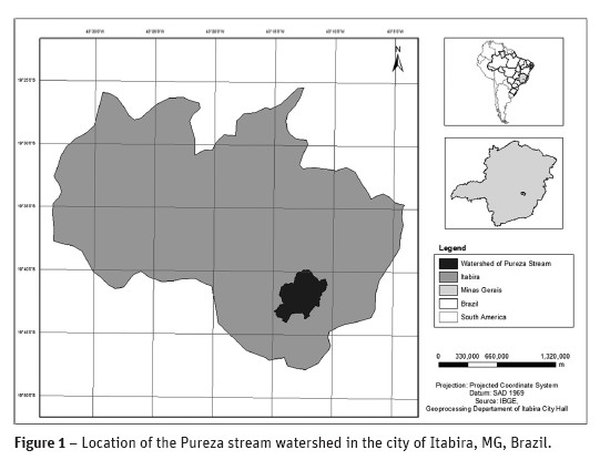
The city of Itabira is located between the parallels 19 and 20° south and the meridians 43 and 44° west. It is approximately 1,254 km² in extent and is within the Doce River watershed, where the average annual rainfall is around 1,200 mm. The population is 109,783 inhabitants, according to the census taken in 2007. The biomes of the municipality are the Cerrado and Atlantic Forest. The climate is tropical with an average temperature of 20.3 °C, an average maximum of 25.4 °C and an average minimum of 15.0 °C. The topography is characterised as very rugged with few flat areas(Cupolillo et al., 2008; Silva et al., 2010; IBGE, 2012; PMI, 2012).
The work was accomplished by means of: rainfall data, hydrographic data, topographical location of roads, and land use classification of the study area. The rainfall data was obtained from a 40 year series from the weather station in the city of João Monlevade, located about 15 km from Itabira. These data are sourced from the National Institute of Meteorology - INMET. The hydrography and topography data, boundary of the study area, location of roads and soil classifications were provided in shape file format by Autonomous System of Water and Wastewater - SAAE of Itabira city. Other data used in the preparation of location maps were obtained by the Brazilian Institute of Geography and Statistics - IBGE.
The software Idrisi 15.0 was used for the standardisation and weighting factors as well as the multi-criteria analysis.
The determination of use and occupation of land was accomplished by the software Spring 5.1.5. This was done by a scaled thematic mapping of the watershed following a pre-analysis classification using an IKONOS high-resolution satellite image from 2004.
Through use of ArcGIS 9.3.1 software it was possible to obtain the Digital Model of Elevation Hydrographic Conditioning – DMEHC; the map of the combination of classes and land use. All of final maps were developed by using this software.
An analysis of the infiltration and soil water flow was undertaken using the previously prepared database. This was performed by using the Balseq Model, proposed by Lobo Ferreira (1981). This model is applied in studies related to water resources management and works with the rainwater system being divided into five components: the direct runoff, surface infiltration, actual evapotranspiration, water retained in soil, and deep infiltration(Lobo-Ferreira, 1981; Oliveira et al., 1994).
One of the methodologies used to select areas for allocation of the catchment boxes was based on fuzzy logic. It rearranges the values of the factors in order to standardise them, so that they can be properly correlated(Dalmas et al., 2011). Criteria involving nominal scales were assigned values according to the normalised scale, which in this study ranged from 0 to 255. Another methodology used to allocate the catchment boxes was the multi-criteria analysis. This was considered legal and environmental aspects, mainly related to the classification, the use and occupation of the land, and the distance from watercourses and roads. The multi-criteria analysis verifies the importance of certain factors/constraints on decision-making(Lima et al., 2008). The restrictions serve to limit certain regions and are expressed in the form of Boolean maps. Thus, the areas that should be excluded from this analysis receive the value 0 and the areas that should be considered receive the value 1. The factors used are those criteria that define the suitability of the region with respect to the variables most relevant to the study. Thus, proceeding to the transformation of the values of the initial data in degrees of relevance, gives rise to the so-called fuzzy functions (Paegelow et al., 2003; Calijuri et al., 2007).
Assigned values for each criterion serve to quantify the relative importance of each in the decision process. The method applied in this study was the pairwise comparison process of decision-making called Analytic Hierarchy Process (AHP). This method calculates a set of weights and a consistency ratio, allowing repeated adjustments to the comparison. The coherence of the process is verified by the determination of the coefficient of the consistency ratio, which evaluates the weighting (Calijuri et al., 2002).
Two procedures were used in the clustering of the criteria: WLC which applies a weight to each factor, and OWA which like WLC also applies weights to the factors, but in this case the weights are ordered in a ranking(Calijuri et al., 2002).
A comparison of the results obtained from the WLC and OWA procedures was made, and because the risk and compensation attributed to each procedure are different, they provide different scenarios regarding the best areas for the deployment of the catchment boxes.
Two restrictions have been considered in the analysis: the limit of the watershed of the Pureza stream and a buffer of 30 m along the length of the watercourse. In the other words, this sets the minimum distance for intervention at the margins of watercourses. Thus, the legal criteria established by the Federal Law of Brazil, no 4.771 of 1965, for the preservation of permanent protection areas are appropriately covered(Brasil, 1965).
The road distance factor was generated using the distance command that evaluates areas of agreement with the distance of the selected object. The following factors were considered in this analysis: distance from roads, distance from the points of intersection between the roads and watercourses, the combination among the classes, land use and slope. The distance factor of the intersection of watercourses was based on the points where roads cross the streams, since these points are considered critical to the silting of rivers. After identifying these points, a buffer zone of 30 m was employed in order to meet the minimum distance for intervention on the margins of watercourses. Then, the command distance was used in order to evaluate the area in relation to these points.
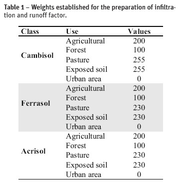
The combination factor among classes and land use also considered the occupation of land, and also the potential for infiltration and runoff in each combination. A greater weight was assigned to those areas whose combinations contribute to a lower infiltration and higher runoff. Therefore, it took into account the results obtained from the Balseq model application, restricting only urban use, since the building of catchment boxes is not required in these areas.
Table 1 presents the weights established for the development of the factor for soil infiltration and runoff.
The slope factor was reclassified taking into account that fact that the higher the slope, the greater will be the need of catchment boxes, since these areas are more susceptible to erosion.
It was assigned the value of: 0 for slopes of up to 3 %, 15 for slopes between 3–15 % due to the potential risk of erosion, 200 for slopes between 15–40 %, and 255 for slopes greater than 40 %, due to these being the most critical areas requiring effective implementation of catchment boxes.
Table 2 summarises the factors and the functions used to normalise the data, as well as their control points.
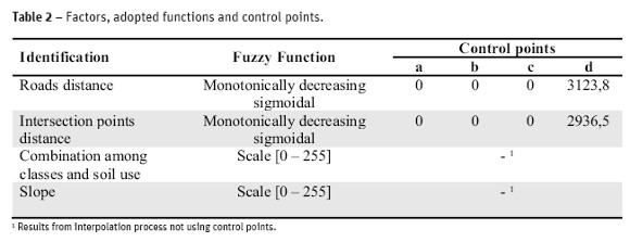
Finally, the weighting of each criterion was estimated using the AHP model where assessments were made among the factors of importance, coming to a consistency of 0.01. The factors used and their weights were weighted: roads distance (0,3961), intersection points distance (0,3961), combination among classes and soil use (0,1170), slope (0,0908).
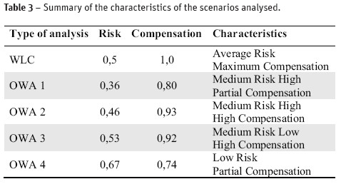
Five scenarios were developed considering different combinations of weights and procedures (WLC and OWA) for purposes of comparison. The characteristics of each scenario are shown in Table 3.
Results and Discussion
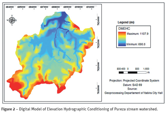
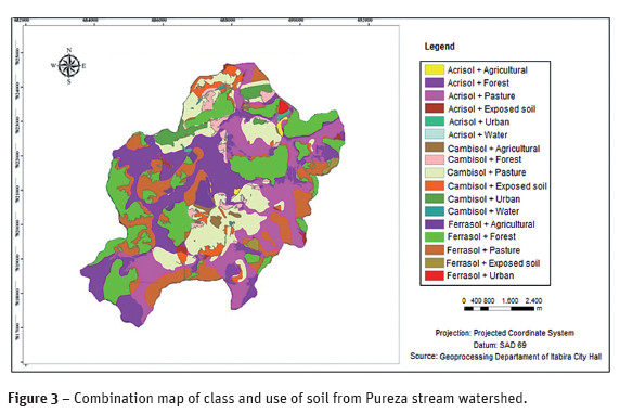
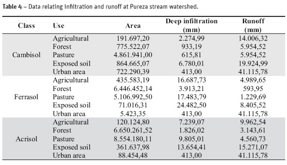
Figure 2 shows the DMEHC (Digital Model of Elevation Hydrographic Conditioning), where the values were extracted from the slope of the study area, and Figure 3 shows the combination of classes of soil and its use. From the combination of these, by use of the Balseq Model, both the infiltration and runoff for the watershed of the Pureza stream was determined and these values are shown in Table 4. Table 4 shows that in the study area: the Ferrasol has a greater infiltration and reduced runoff, the Cambisol is deficient in soil infiltration and has a high susceptibility to runoff, and the Acrisol has an intermediate behaviour of both.
It is known that the infiltration capacity does not depend solely on the class to which a particular soil belongs. Several factors may influence this aspect such as: relief, soil texture, geology, land cover, and others(Brito et al., 2006; Soares et al., 2008; Cunha et al., 2011a).
The area studied by Soares et al. (2008) was classified as Cambisol, which would be expected to have shown a low infiltration capacity, but the opposite was detected. The coverage type for this class of soil was identified as being responsible for the high value of infiltration: in this case, the forest was predominantly Cambisol.
The same happened in the work of Ottoni Filho (2003), studying Oxisols. Low infiltration rates were detected, which is unexpected for Oxisols. A possible explanation pointed out in this study, is also related to the area use. The inadequate management, especially as regards irrigation, was probably responsible for this result.
Thus, the Cambisol was prioritised in relation to the Ferrasol and Acrisol, for the strategic analysis of the catchment box allocation, as it is more susceptible to erosion, and therefore to contributing particles and sediments to the watercourses.
Therefore, the importance of land use has been prioritised for those areas where infiltration is lower, such as pasture and areas of exposed soil, followed by agricultural use and lastly, with less weight, the areas occupied by forest.
Figure 4 shows the results obtained by analysing the multi-criteria type WLC, for medium risk and the maximum compensation.
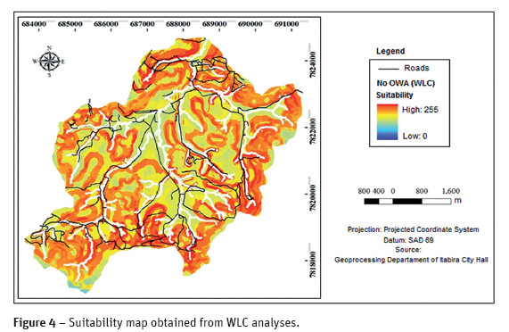
Due to the preventive nature of analysis for catchment box allocation, it is possible that the choice of the best-case scenario assumes a higher risk. Therefore, following the OWA1 analysis, it was decided to select relevant areas with a suitability analysis of at least 250. However, the most critical areas correspond to the WLC analysis with a suitability analysis of 255, which must necessarily be allocated catchment boxes.
Figure 5 shows the different suitability maps obtained through analysis OWA.
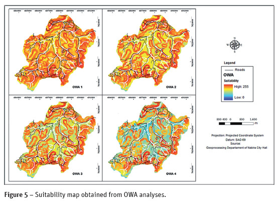
In order to investigate the possibilities of the areas for deployment of catchment boxes, an analysis was performed using the Run Macro command/site select, using suitability values equal to 255, 250 and 240 for each of the generated models, with the intention of finding areas larger than 0.0003 ha. The result is presented in Table 6.
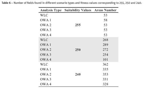
Figure 6 show the critical and suitable areas within the Pureza stream watershed.
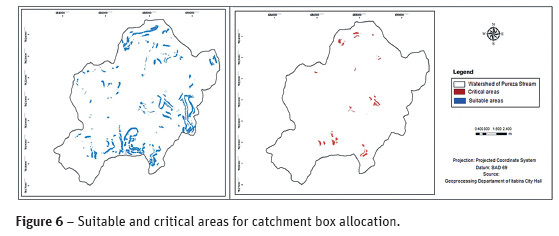
In accordance with adopted procedure, 289 areas have been identified as suitable for deployment for catchment boxes. These areas are identified from the WLC and OWA scenarios, which present a risk equivalent to 0.36, and compensation equivalent to 0.80, in other words, an average risk-top with partial compensation.
In relation to the WLC scenario, 53 critical areas were identified for an average risk and maximum compensation, which should necessarily be observed for deployment of catchment boxes.
It is important to determine the spatial allocation of the catchment boxes in the field, as well as identifying the number of them to be installed. This fact is emphasised by the range of areas which were highlighted as suitable for this aim, and this can be considered as a positive point in this methodology.
Conclusions
The proposed methodology was efficient in the allocation of catchment boxes on the roads. Through its implementation, the government may have a better management of unpaved roads, where not only will their conservation will be provided, but also the quality and production of water in watersheds will be improved.
The scenarios WLC pointed 53 areas in the Pureza stream watershed that, on a greater urgency, must necessarily be considered for installation of the catchment boxes.
The field verification and the correct determination of the required number of catchment boxes for road conservation and water resource improvement are essential to the success of this methodology.
References
Avelino, P.H.M. (2004) - A trajetória da tecnologia de sistemas de informação geográfica (SIG) na pesquisa geográfica. Revista Eletrônica da Associação dos Geógrafos Brasileiros, vol. 1, n. 1, p. 21–37. [ Links ]
Brasil (1965) - Ministério da Justiça. Institui o Novo Código Florestal. Decreto-lei nº 4771, de 15 de setembro de 1965. [ Links ]
Brito, M.G.; Costa, C.N.; Almeida, J.A.; Vendas, D. and Verdial, P.H. (2006) - Characterization of maximum infiltration areas using GIS tools. Engineering Geology, vol. 85, p. 14-18. [ Links ]
Calijuri, M.L.; Loures, S.S.P.; Santiago, A.F.; Schaefer, C.E.G.R.; Lugão, W.G. and Alves, J.E.M. (2007) - Identificação de áreas alternativas para disposição de resíduos sólidos na região do Baixo Ribeira do Iguape – SP. Eng. Sanit. Ambiental, vol. 12, n. 3, p. 335–342. [ Links ]
Calijuri, M.L.; Melo, A.L.O. and Lorentz, J.F. (2002) - Identificação de áreas para implantação de aterros sanitários com uso de análise estratégica de decisão. Informática Pública, vol. 4, n. 2, p. 231–250. [ Links ]
Casarin, R.D. and Oliveira, E.L. (2009) - Controle de erosão em estradas rurais não pavimentadas, utilizando sistema de terraceamento com gradiente associado a bacia de captação. Revista Irriga, vol. 14, n. 4, p. 548–563. [ Links ]
Cunha, A. M.; Lani, J. L.; Costa, L. M.; Fernandes Filho, E. I. and Amaral, E. F. (2011a) - Morphological, physical and pedogenetic attributes related to water yield in small watershed in Guarapari/ES, Brazil. Revista Ceres, vol. 58, n. 4, p. 493-503. [ Links ]
Cunha, F.F.; Leal, A.J.F. and Costa, A.S.V. (2011b) - Implantação de uma estrada não-pavimentada na microbacia hidrográfica de Palmital. Revista de Ciência e Tecnologia do Vale do Mucuri, vol. 3, n. 3, p. 89-105. [ Links ]
Cupolillo, F., Abreu, M.L. and Vianello, R.L. (2008) - Climatologia da Bacia do Rio Doce e sua relação com a topografia local. Geografias, 4, 1: 45–60. [ Links ]
Dalmas, F.B.; Goveia, S.S.; Oliveira, F.R.; Amaral, C.H. and Macedo, A.B. (2011) - Geoprocessamento aplicado à gestão de resíduos sólidos na UGRHI-11 – Ribeira de Iguape e Litoral Sul. Geociências, vol. 30, n. 2, p. 285–299. [ Links ]
Demarchi, L.C.; Rabello, L.R.; Santos, N.B.; Franco, O. and Correa, R.O. (2003) - Adequação de estradas rurais: Manual Técnico do ano de 2003. Campinas: CATI, 2003. 64 p. CATI. Manual Técnico, 77. [ Links ]
Emmert, F.; Pereira, R.S.; Rezende, A.V. and Encinas, J.M.I. (2010) - Geoprocessamento como ferramenta de apoio à gerência de paviementos em estradas florestais. Ciência Florestal, vol. 20, n. 1, p. 81–94. [ Links ]
Goldani, J.Z. and Cassol, R. (2008) - Ocupação antrópica e sócio-ambiental da microbacia do Rio Vacaí-Mirim – RS. Geomática, 3, 1: 48–59. [ Links ]
IBGE (2012) - Instituto Brasileiro de Geografia e Estatística. Cidades. 2012. [ Links ]
INMET (2012) - Instituto Nacional de Meteorologia.. Dados meteorológicos. 2012. [ Links ]
Lima, J.P., Ramos, R.A.R. and Fernandes Júnior, J.L. (2008) - Priorização de pavimentos com o uso da metodologia de análise multicritério e SIG.Engevista, vol. 10, n. 2, p. 132–144. [ Links ]
Lobo-Ferreira, J.P. (1981) - Mathematical model for the evaluation of the recharge of aquifers in semiarid regions with Scarce (Lack) hydrogeological data. European Mechanics Colloquium – Euromech, 143, Flow and Transport in Porous Media, 1981, Rotterdam, p. 2–4. [ Links ]
Oliveira, J.F.; Griebeler, N.P.; Garvil, R.A.; Oliveira, J.M. and Rabelo, M.W.O. (2011) - Uso do software Estradas para a determinação do espaçamento entre desaguadouros em estradas não pavimentadas do interior de Goiás. Revista Ceres, vol. 58, n. 1, p. 17–22. [ Links ]
Oliveira, M.M.; Moinante, M.J. and Lobo-Ferreira, J.P. (1994) - Estudo da caracterização dos aquíferos e dos consumos de água na Península de Setúbal. Relatório Final. Lisboa: Laboratório Nacional de Engenharia Civil. Relatório 37/94 – GIA. [ Links ]
Ottoni Filho, T. B (2003) - Uma classificação físico-hídrica dos solos. Revista Brasileira de Ciência do Solo, vol. 27, p. 211-222. [ Links ]
Paegelow, M., Camacho Olmedo, M. T. Y., Menor Toribio, J. (2003) - Cadenas de Markov, evalución multicriterio y evaluación multiobjetivo para la modelización prospectiva del paisaje, GeoFocus, vol. 3, p. 22–44. [ Links ]
Rezende, W.S., Gobbi, C.N.; Silva, C.E. and Almeida, J.R. (2011) - Recuperação de voçorocas na zona rural do município de Mineiros (GO): financeiramente viável e ambientalmente sustentável. Revista Ibero-Americana de Ciências Ambientais, vol. 2, n. 2, p. 64–81. [ Links ]
Silva, S.H.L.; Braga, F.A. and Fonseca, A.R. (2010) - Análise de conflito entre legislação e uso da terra no município de Itabira – MG. Caminhos de Geografia, vol. 11, n. 34, p. 131–144. [ Links ]
Silva, T.O., Carvalho, C.A.B., Calijuri, M.L. and Lima, D.C. (2009) - Sistemas de informações geográficas como suporte à gerência de manutenção de rodovias vicinais não pavimentadas. Revista Brasileira de Cartografia, vol. 61, n. 3, p. 301–309. [ Links ]
Soares, P. V.; Pereira, S. Y.; Simões, S. J. C.; Bernardes, G. P. and Barbosa, S. A. (2008) - Mapa de infiltração do alto e médio Vale do Paraíba do Sul com base em elemtnos do meio físico e na precipitação. Ambi-Agua, vol. 3, n. 1, p. 26-42. [ Links ]
Zoccal J.C.; Brandão H.F.; Silva J.R. and Matheus N.O. (2007) - Adequação de erosões: causas, consequências e controle da erosão rural. Soluções: Cadernos de estudos em conservação de solo e água do ano de 2007. São Paulo, CODASP, 2007. 62 p. [ Links ]
Recebido/Received: 2012.08.27
Aceitação/Accepted: 2013.09.23

