


 Inglês (pdf)
 Artigo em XML
 Referências do artigo
 Enviar este artigo por email
 Citado por SciELO
  Similares em
SciELO
Similares em
SciELO 
 Permalink
INTRODUCTION
Once considered a fruitless desert, the Northwestern Negev situated in the semi-arid zone of Israel, is nowadays one of the most productive agricultural regions of the country. Despite its small area, this region produces high yields and is rich in soil diversity (Dan & Nissim, 1988; Yaalon, 1997; Shapiro, 2006). Until the beginning of this century, there was a water supplement shortage for agricultural uses. Desalination processes and wastewater treatments development allowed a significant expansion of irrigated territories and the incorporation of new subtropical crops characterized by high demand for water. This situation required a suitability assessment of soils that were previously under dryland farming practices.
The optimal agricultural development of new irrigated territories involves assessment of three main soil issues: soil diversity, soil properties limiting agricultural use and soil distribution patterns. Considering these issues as a tool for proper land designation for agricultural uses, a soil-landscape study has been conducted in the semi-arid zone of Northwestern Negev.
MATERIAL AND METHODS
The Northwestern Negev region is characterized by intensive agricultural land use with plenty of irrigated field crops and plantations, as well as numerous greenhouses. Sites unsuitable for farming are afforested mainly by different species of pines and eucalyptuses. Badland areas are recognized as tourist attractions due to their recreational value. The whole regional abounds with numerous cultural heritage sites of different periods. The study area (about 90,000 ha - Figure 1) is situated in a semi-arid zone with an average annual rainfall of 200 to 400 mm.
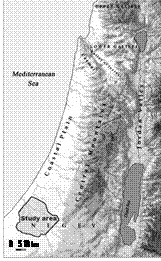
This area can be divided into three main geomorphological regions (Singer, 2007). The eastern one is represented by low smooth hills, composed of conglomerates and outcrops of carbonate Paleogene rocks (mainly chalks) with stony shallow Lithosols (see Figure 2). The central region is occupied by the ancient (Neogene-Pleistocene) alluvial plain. Its south area is covered by sandy loess Pleistocene sediments with Sandy soils, while the central and north areas consist of Pleistocene loess sediments with Light brown soils and sometimes Serozems. The west coastal region is formed by Pleistocene seaside dunes, composed of carbonate sandstone with a complex of specific soils among which Pararendzinas and Reddish-brown calcareous soils (local name - Husmas) dominate.
Several large ephemeral streams with Alluvial soils dissect the territory in an east-west direction, where the valleys of Gerar and Besor streams and their tributaries are the largest. Inside the valleys the badlands are common, where Regosols are usually found.
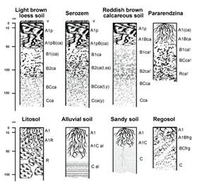
In order to determine soil properties limiting agricultural use the following resources have been analyzed using ArcGIS Spatial Analyst extension: environmental factors, aerial photographs of different years, detailed soil maps, morphological descriptions and chemical data of selected soil profiles. This analysis allowed to create middle-scaled soil and soil limitations maps that can be used for land use planning. The soils were classified according to Israeli soil classification system (Dan & Koyumdjiski, 1979).
RESULTS AND DISCUSSION
Soil properties limiting intensive agricultural use
There is a wide range of soil properties that restrict the achievement of planned yield and/or contribute to landscape transformation during agricultural use. In this study, soil properties concerning widespread plantations of citrus crops and avocado will be considered. Table 1 shows the main limiting properties typical for soils in the study area.
The first group of limiting properties is related to the soil profile itself represented as a vertical stratigraphic column divided into horizons. In terms of agricultural uses, the main quality of such a column is its internal drainage capacity due to the high amount of water required for sub-tropical crops. In this case, semi-arid soils receive 2,5-3 times more moisture than in natural conditions. At the same time, to obtain high yields moisture stagnation in the root layer is unsuitable. The most important properties that affect the degree of internal soil drainage are the following: transitions between genetic horizons in terms of soil texture (gradual transitions are ideal), absence of highly compacted horizons in the subsoil layer, absence of horizons and interlayers cemented by carbonate or gypsum, low soil dispersion of the soil mass during irrigation (SAR values lower than 8), and absence of dense rocks in the upper half-meter layer near the surface (for example, chalk or cemented conglomerate).
The second group concerns the chemical soil properties. In the semi-arid regions of Israel, the following thresholds are suggested: pH values lower than 8.5; electrical conductivity values caused by soluble salts should not exceed 4 dS/m, boron content in the paste filtrate lower than 1 ppm, total carbonates content lower than 25% of the weight of the fine-textured soil mass, and carbonates content in the clay fraction of soils lower than 10%.
Thirdly, as it is known, the soil profile is an open system closely related to landscape components. Therefore, it is required to assess, at least qualitatively, the degree of landscape and soils stability and their capacity to withstand physical changes under the influence of wind, rain and irrigation. In other words, soil erosion tendency should be taken into consideration. Regarding soils formed from loess parent material, the following criteria are suggested: slopes steepness lower than 3-4%, absence of surface crust that enhances erosion effects, and the propensity of the territory to piping erosion. In areas where loamy soils to clay loamy soils spread out, deep cracks may appear on soil surface, especially if swelling three-layer montmorillonite clays are present. Moreover, in the case of areas covered with loamy soils to sandy soils, slope aspect plays an important role: sunny southern slopes tend to be less protected from wind erosion than northern ones. Lastly, the main challenge of sandy soils remains high water drainage rates, whereas regarding alluvial soils it is periodic flooding.
Table 1 Main limiting soil properties
| Limiting properties | Soils | |||||||
| 1 | 2 | 3 | 4 | 5 | 6 | 7 | 8 | |
| Crust | X | X | ||||||
| Thickness | X | X | X | |||||
| Sharp transition between horizons | X | X | X | X | X | X | ||
| Topsoil compaction | X | X | ||||||
| Cementation by carbonates | X | X | ||||||
| Cementation by gypsum | X | |||||||
| Electrical conductivity | X | X | ||||||
| SAR | X | X | X | X | ||||
| B content | X | X | X | X | ||||
| CaCO3 (total) | X | X | X | |||||
| CaCO3 (clay) | X | X | ||||||
| Water erosion | X | X | ||||||
| Wind erosion | X | |||||||
| Flooding | X | |||||||
Soils: 1 - Light brown loess soils; 2 - Serozems; 3 - Reddish brown calcareous soils; 4 - Pararendzinas; 5 - Lithosols; 6 - Alluvial soils; 7 - Sandy soils; 8 - Regosols.
CONCLUSIONS
Soil diversity assessment is an essential tool for land use planning, due to the demands for the transformation of marginal lands into arable lands, and the shifting from dryland farming to irrigated farming. Main soil properties (14) convenient for such assessment were listed in order to evaluate the semi-arid soils of Northwestern Negev, Israel. These properties are regarded as factors that limit the sustainable development of irrigated lands. This set of criteria may be applied in territories of the Mediterranean region similar to the study area landscape in terms of climate, landform, parent material, and soils.

