


 Inglês (pdf)
 Artigo em XML
 Referências do artigo
 Enviar este artigo por email
 Citado por SciELO
  Similares em
SciELO
Similares em
SciELO 
 Permalink
INTRODUCTION
The “Campanha Gaúcha” Geographical Indication was recognized in Brazil in 2020 (Revista Rural, 2020). Bordering Uruguay and Argentina, it is the second largest wine producing region in the country, where vineyards are cultivated in the Pampa biome, in an area where livestock is predominant (EMBRAPA, 2006; Protas and Camargo, 2011).
According Tonietto et al. (2012), geodiversity implies the formation of soils and reliefs, leading to agronomic responses in the vineyard, conditioning the valorization of wine production, characterizing different terroirs. A geophysical study was carried out to distinguish the types of volcanic rock in the Serra Gaúcha wine region (Modena et al., 2016) and vineyard landscape and geology studies were carried out in the wine region of the "Campanha Gaúcha" (Hoff et al., 2018).
Regarding viticulture, excess potassium has been identified as a problem for the production of grape juice and wine in tropical areas (Kodur, 2011), influencing the acidity of the product, which can make it of low quality compared to consumers. In an area with sandy and leached soil and with conventional agriculture, as in parts of the “Campanha Gaúcha” Geographical Indication (Hoff et al., 2018), the soil has undergone profound changes, which can and cause, among other things, the loss of organic matter (Sena et al., 2017). The mapping of these aspects can support agricultural management, either by the potassium content of the soil by the radio-element K and by the inference of the presence of organic matter by the radio-elements U and Th.
The application of geotechnologies in precision agriculture would make it possible to identify the variability of certain attributes in cultivated areas; this variability may be associated with variations in relief, vegetation, soil and management history of these areas (Bernardi et al., 2014). In soil development, the processes of leaching and concentration of elements in different portions of a soil profile can lead to the availability of different nutrients for the crops grown in them.
According to Dickson and Scott (1997), the fact that the soil covers the earth's surface makes the relationship between radio-elements in the surface cover and the underlying rock very important in geophysical surveys. Thus, the non-invasive gamma spectrometry method was applied to distinguish radio-elements from the soil surface of a vineyard area.
The study was carried out in a winegrowing area of Almadén Winery (Miolo Wine Group) in the “Campanha” Wine Region, “Santana do Livramento”, Brazil. The Vitis vinifera cultivars in this area are Cabernet Sauvignon (90.643 ha), Tannat (69.283 ha), Merlot (53.742 ha), Italian Riesling (39.856 ha), Cabernet Franc (30.462 ha), Chardonnay (19.546 ha), Chenin Blanc (18.164 ha), White Muscat (13.407 ha), Sauvignon Blanc (11.767 ha), Alicante Bouschet (9.252 ha), Gamay Noir (9.054 ha), Gewurztraminer (8.776 ha), Rhineland Riesling (6.846 ha), Colombard (5.441 ha), Syrah (4.139 ha), Semillon (2.857 ha), Hamburg Muscat (2.336 ha), Collection of vinifera (1.135 ha), Marselan-Arinarnoa (0.45 ha) and Ekigaina (0.16 ha).
The general objective of this study was to evaluate the distribution of radio-elements in the soil of vineyards, using the gamma-ray spectrometry method. The specific objectives were: 1) to evaluate the variation in the levels of radio-elements U (uranium), Th (thorium) and K (potassium); 2) to relate the distribution of radio-elements analyzed to soils and mapped geological units; 3) to contribute to the zoning of the vineyards, classifying the radio-element zones in relation to the relief and indicating areas to be monitored in relation to the potassium (K) content and inferring the content of organic matter, through the contents of U and Th.
The gammaspectrometric data are the radiation emitted from radio-elements and do not represent the amounts present in the soil, such as potassium, for example. This study only indicates the distribution of potassium from areas to be monitored through soil chemical analysis, to support the management of vines. Likewise, the contents of uranium and thorium are indicative of the occurrence of organic matter in the soils of the vineyards, supporting their maintenance.
Geochemistry of K, U and Th and their occurrence in soils
The most common occurrences of K are observed in potassium feldspar and mica, common in acidic igneous rocks (Dickson and Scott, 1997), less in basic igneous rocks. Due to the solubility of potassium minerals, there is depletion in weathered rocks and soils. K minerals, during chemical weathering, undergo alteration (biotite, feldspar and muscovite). Thus, during the weathering process, K can form illite or adsorbed in smaller amounts by other clay minerals (montmorillonite).
Uranium occurs in low concentration at the lithosphere, approximately 3 ppm (Dickson and Scott, 1997). The U is in form of U4+ and U6+, former usually contained in non-soluble minerals, the latter associates with anions in carbonates, sulfates and phosphates to form soluble species. The mobility of U6+ is modified due to adsorption by hydrated iron oxides, clay minerals and colloids, and also by transformation into U minerals in reducing environments. U in rocks is associated with oxides and silicates, pitchblende and uranotorite, monazite, xenothyme and zircon. According to Wu et al. (2001), the adsorption and mobility of U are influenced by OM contents in soils.
Van der Weijden and Van der Weijden (1995) described hot and humid climatic conditions as factors for U leaching, when there is circulation of water, generally acidic, containing dissolved oxygen and carbon dioxide. This can be cause of hydrolysis, oxidation and consequent leaching in form of hydroxyl ion (UO2)2+, minerals containing U, except for refractories.
Th occurs in minerals such as alanite, monazite, xenothyme and zircon, in concentrations greater than 1000 ppm or in trace amounts in other minerals (Dickson and Scott, 1997). Monazite and zircon are stable during weathering, accumulating in heavy mineral deposits. During weathering, Th can be retained in Fe and Ti oxides, hydroxides and clay. When adsorbed, Th can be transported in clay colloids and iron oxides. The occurrence of adsorption and Th mobility are directly influenced by the organic matter (OM) contents in the soils (Wu et al., 2001). According to Rebello (2000), the Th remains fixed during weathering and pedogenesis, due to its low geochemical mobility. The products of its decay reveal low mobility and consequent low concentration in the solution. However, humic acids and specific acidic pH conditions can cause the Th mobility.
Dickson and Scott (1997) showed that, in alteration zones from intrusive and extrusive igneous rocks, intermediate and basic, there are significant variation in the saprolite-soil interface. These changes are reflection of K losses from the potassium feldspar and mica and the retention of U and Th. These authors also analyzed the weathering effects on rocks and the content of radio-elements in Australian soils, based on laboratory measurements. In the case of soils, there is a potential for radiometric imbalance between the parent isotope U and 226Ra, given the disparity in the geochemical character between the two radio-elements and the long-lived isotope 230Th. In a study about the imbalance of U-226Ra in the same soils, found a wide spread in the imbalance in species, although they were richer in U than in 226Ra (Dickson and Scott, 1997). These authors state that average contents of radioactive elements for soils derived from sandstones correspond to the values: 1.3 % of K; 2.1 ppm U; 11 ppm of Th. These contents are similar to those of the parent rock, as shown in Table 1.
Soils originated from sandstone poor in radioactive elements can show different effects due to the contamination of transported material, according to Dickson and Scott (1997). This results in higher radioactive element values relative to the underlying rock, although intercalation effects with claystone layers also need to be considered. Soils originated from shale, contain the following contents of radioactive elements (Table 1): 1.5 % K; 2.3 ppm U; and 13 ppm of Th. This suggest that the pedogenesis process resulted from large loss of K while there was a retention of approximately 70 % of U and Th in relation to the parent rock. The occurrence of the silicification process can preserve the units occurring close to the surface in weathering, resulting in Th-rich areas corresponding to the highest topographic levels.
Table 1 Content of radioactive elements in sedimentary rocks and their soils, showing mean values in parentheses, according Dickson and Scott (1997)
| Sedimentary rocks | Rock | Soil | ||||
| K (%) | U (ppm) | Th (ppm) | K (%) | U (ppm) | Th (ppm) | |
| Archean shales | 0.4-1.6 (0.9) | 0.3-1.3 (0.9) | 1-5 (2.7) | 0.8 | 1.2 | 3 |
| Other shales | 0.1-4.0 (2.6) | 1.6-3.8 (2.6) | 10-55 (19) | 0.7-3.0 (1.5) | 1.2-5 (2.3) | 6-19 (13) |
| Sandstone | 0.0-5.5 (1.8) | 0.7-5.1 (2.3) | 4-22 (12) | 0.1-2.4 (1.3) | 1.2-4.4 (2.1) | 7-18 (11) |
| Carbonates | 0.0-0.5 (0.2) | 0.4-2.9 (1.6) | 0.0-2.9 (1.4) | - | - | - |
MATERIAL AND METHODS
In the studied area, were investigated 115 vineyards (409.853 hectares), that belong to Almadén Winery (Miolo Wine Group), located at “Santana do Livramento” municipality, Brazil, with geographic coordinates: 30° 47' 28'' South and 55° 22' 47'' West (Figure 1). The vineyards vector data were obtained from wine registry in Rio Grande do Sul (Mello and Machado, 2017). The cartographic basis was geology from Wildner et al. (2008); soil units were digitalized from a mapping from Flores (2007) and; vectorial layers such as rivers, roads and boundaries from IBGE (2013).
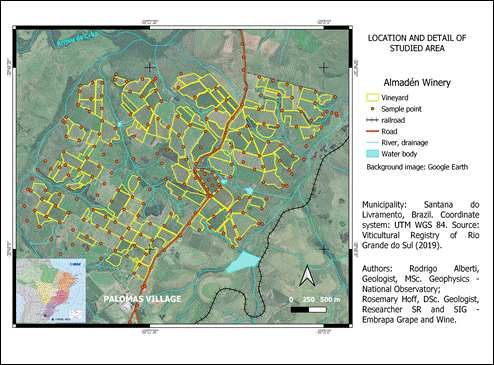
Figure 1 Location and detail of the study area, showing the vineyards and sample points. “Santana do Livramento”, Brazil. Cartographic base: IBGE (2013). Elaborated by the authors.
The ALOS RT1 image was used, whose digital elevation model (DEM) comes with a resolution of 12.5 m. The images were obtained free of charge by the Alaska Satellite Facility (ASF), which is a product generated from radar data (ALOS PALSAR) with radiometric terrain correction (ASF Engineering, 2015).
Image processing and geoprocessing were performed using the free software QGIS version 3.14 (QGIS, 2020). The DEM was interpolated by kriging, following the steps of vectorization in points (12.5 in 12.5 m), in order to generate an image of five-meter resolution, aiming at a better visualization of the vineyards, without changing the original values of the terrain image (Hoff et al., 2017; Junges et al., 2017). From the digital elevation model resampled, aspects of hypsometry were investigated and was integrated with classified radio-element images.
The field work was made in July and August 2018, measured total count (TC), K (%), U (ppm) and Th (ppm), all isotopes. The measurements were made by portable gamma-ray spectrometer (Radiation Solutions/Super Spec RS-125) with 1024 spectral channels (Radiation Solutions Inc.), configured to register counts for 180 seconds. The measurements were done on direct physical contact between the equipment and the soil, using the ‘Assay’ option for all measures, that were saved in the equipment memory as well as manually recorded in a spreadsheet. Geographic coordinates were obtained by high precision GPS for each data collection point.
Data were measured every 200 meters in the vineyard area, totalizing 259 points, by contact with the gamma spectrometer on the surface of soil. In order to analyze the vertical variation of radio-elements, two profiles were made, being the gamma radiation measured at every 10 cm, from the bedrock to the surface of the terrain by contact with the gamma spectrometer on the profile wall. The walls of the profiles were 190 and 200 cm.
Statistical calculations were based on Pimentel Gomes et al. (1995), in the Libre Office Calc software. The radio-elements images were generated by universal kriging interpolation and their maps were made by QGIS 3.10 software. Seeking to differentiate the measurements to the types of soils, descriptive statistics and comparative graphics were used. Maps of elements and parameters were elaborated, aiming at zoning the vineyard, in terms of radio-elements and their arithmetic operations.
From the maps of U, Th and K, the concentrations were cutting by the polygons of the vineyards, in order to show the producer about the contents of these elements in the soil of each vineyard. This can also provide the values from radio-elements excluding what was not planted with vinifera grapes. Therefore, the values of radio elements were recalculated in these new areas, to the best view of radio-elements at the vineyards.
Geological and pedological context around the vineyards
According to Wildner et al. (2008), there are three lithostratigraphic units in the studied area: Alluvial Deposits, “Guará” Formation and “Sanga do Cabral” Formation. The Alluvial Deposits are found in the NNW and NE portions of the study area, comprising deposits of coarse to fine sand, gravel and silt-clay sediment, in river channels and floodplains. These deposits occur along the main rivers in the wine region. In the northern portion of the studied area, the “Arroio da Cruz”, exhibits a strip of alluvial deposits with a width between 0.5 and 1 km.
The “Guará” Formation is predominant in the studied area, as shown in Figure 2. This lithostratigraphic unit occurs from the “Santana do Livramento” to “Jaguari” municipality (Scherer and Lavina, 2005), limited to the North by a NW direction fault system, and may have a thickness of up to 120 meters, average 60 meters. These authors classified four facies associations for this lithostratigraphic unit, as follows: Large cross-bedding sandstones (dunes); Sandstones with horizontal stratification (wind sand sheets); Laminated pelite and solid sandstone (distal floodflow deposits); Medium to very coarse stratified sandstones (river channels).
The “Sanga do Cabral” Formation, the unit with the lowest occurrence in the studied area, is located in the northeast region (Figure 2A). According to Lavina et al. (1993), this lithostratigraphic unit is formed of reddish quartz sandstones, of fine to medium bimodal grain, with flat and rounded grains. Medium-sized tangential cross-bedding can be observed in this sandstone, indicating predominant paleocurrents to the southeast. These facies are intercalated with reddish sandstone, fine to medium granulometry, clayey matrix and sub-horizontal stratification, constituting, respectively, two and moist interdune deposits. The area and geographic distribution of the lithostratigraphic units is shown in Figure 2A and Table 2.
The soil units in the study area were mapped by Flores et al. (2007) on a scale of 1:50,000, based on the Brazilian Soil Classification System (Santos et al., 2018). The Alisols occur in all extension of the studied area and in a smaller portion at the south. These soils are constituted by mineral material, with textural B horizon or nitic B horizon, with clay with an activity equal to or greater than 24 cmol/kg of clay and presenting a high content of extractable aluminum, in addition to having aluminum saturation greater than 50 % and/or base saturation less than 50 % in most of the B horizon, and meeting the requirements: a) plinthic horizons, if present, is not above B and neither coincident with the surface part of it; b) Glei horizon, if present, starts after 50 cm of depth and does not coincide with the superficial part of the B horizon, nor does it occur until this horizon (Santos et al., 2018).
The Argisols or Acrisols according WRB/FAO classification (Santos et al., 2018) occur throughout the study area, mainly at highest elevation terrains. These soils are compound of mineral material, presenting textural B horizon immediately below the A or E, with low activity clay, or high clay combined with low base saturation, or lithic contact in most of the B horizon.
The Planosols occur in the northeast and northwest portions of the area, comprising the lower elevation zones. These soils are compounded by mineral material with an A or E horizon followed by a B horizon. This horizon without any sodic character loses taxonomic precedence to the plinthic horizon (Santos et al., 2018). The quantities in area and distribution are shown in Table 2 and Figure 2B.

Figure 2 Lithostratigraphic units according Wildner et al. (2008) (A). Soil units, according Flores et al. (2007) (B). “Santana do Livramento”, Brazil. Cartographic base: IBGE (2013). Elaborated by the authors.
Table 2 Area of lithostratigraphic and soil units around the study area. According to Wildner et al. (2008) and Flores et al. (2007). Elaborated by the authors
| Class | Area (ha) | Area (%) |
| Lithostratigraphic units | ||
| Alluvial Deposits | 184.66 | 8.69 |
| Guará Formation | 1898.91 | 89.35 |
| Sanga do Cabral Formation | 41.74 | 1.96 |
| TOTAL | 2125.31 | 100.000 |
| Soil mapping units | ||
| Alisol | 973.88 | 45.82 |
| Argisol | 738.63 | 34.75 |
| Planosol | 412.80 | 19.42 |
| TOTAL | 2125.31 | 100.000 |
Results and discussion
Relief context of vineyards
The altitude of the area studied around the vineyards varies from 147 to 229 meters above sea level (Figure 3A). The lowest altitudes are located to the northwest, in the valley of the "Arroio da Cruz" and other at northeast by its main tributary. The highest elevations are at the center of the area, the tops being the gentle sandy hills, coinciding with the vineyards. For a better understanding of the distribution in area of elevation into the vineyards, a hypsometric classification was made into three classes as shown in Figure 3B and Table 3.

Figure 3 Altimetry around the vineyards (A) from ALOS DEM 12.5 m resolution. Hypsometry into vineyards (B) resample to 5 m resolution, at Almadén Winery, “Santana do Livramento”, Brazil. Cartographic base: IBGE (2013). Elaborated by the authors.
Table 3 Hypsometry into vineyards at Almadén Winery, “Santana do Livramento”, Brazil. Elaborated by the authors
| Hypsometry classes (m) | Area (ha) | % |
| Low (147.37 - 175) | 50.28 | 12.31 |
| Medium (175 - 200) | 238.33 | 58.32 |
| High (200 - 228.62) | 120.00 | 29.37 |
| Total | 408.62 | 100.00 |
Radiometric measurements
The points of measurement were 259 (Figure 1), distributed by soil types as shown in Table 4. Statistical parameters such as arithmetic mean, median, mode, standard deviation, variance, minimum and maximum values were obtained. The evaluation of the dispersion of the coefficient of variation data, according to Pimentel Gomes (1985) being less than or equal to 10 %, low dispersion; between 10 and 20 %, medium dispersion; between 20 and 30 %, high dispersion; more than 30 %, very high dispersion. The statistical summary of radio-element values for Alisols, Argisols and Planosols is presented in Table 5.
Table 4 Number of points measured for each soil unit, according Flores et al. (2007). Elaborated by the authors
| Soil unit | n |
| Alisol | 84 |
| Argisol | 138 |
| Planosol | 37 |
| Total | 259 |
Table 5 Statistical values on gamma spectrometry obtained for the soil mapping units, according Flores et al. (2007). Elaborated by the authors
| Parameter | K (%) | U (ppm) | Th (ppm) |
| Alisol (n=84) | |||
| Arithmetic average | 0.190 | 0.625 | 2.702 |
| Median | 0.200 | 0.500 | 2.500 |
| Mode | 0.000 | 0.000 | 1.500 |
| Standard deviation | 0.162 | 0.665 | 1.736 |
| Variance | 0.026 | 0.442 | 3.012 |
| Coefficient of Variation (%) | 85.202 | 106.329 | 64.226 |
| Minimum | 0.000 | 0.000 | 0.000 |
| Maximum | 0.700 | 2.900 | 7.600 |
| Argisol (n=138) | |||
| Arithmetic average | 0.221 | 0.522 | 2.991 |
| Median | 0.200 | 0.200 | 2.500 |
| Mode | 0.000 | 0.000 | 2.500 |
| Standard deviation | 0.243 | 0.676 | 1.870 |
| Variance | 0.059 | 0.457 | 3.495 |
| Coefficient of Variation (%) | 109.815 | 129.426 | 62.499 |
| Minimum | 0.000 | 0.000 | 0.000 |
| Maximum | 1.900 | 3.000 | 8.600 |
| Planosol (n=37) | |||
| Arithmetic average | 0.286 | 0.716 | 2.362 |
| Median | 0.200 | 0.500 | 1.600 |
| Mode | 0.200 | 0.000 | 1.500 |
| Standard deviation | 0.215 | 0.694 | 1.561 |
| Variance | 0.046 | 0.481 | 2.436 |
| Coefficient of Variation (%) | 74.892 | 96.870 | 66.072 |
| Minimum | 0.000 | 0.000 | 0.500 |
| Maximum | 0.800 | 2.900 | 7.300 |
The graphics of K, Th and U contents (Figure 4), for the three soil units, show that their behaviors are similar and, possibly, the variables indicate similarity between the soil types in the study area.
The K percentage frequency graphics (Figure 4A) were not divided into classes, due to the small amount of different values of the variable in the sample set. It was possible to verify the similarity of behavior of the Alisols and Argisols, with the highest percentage of samples equal to 0 % K. It was observed in Argisols the occurrence of a sample with K equal to 1.9 %, which can be considered an outlier of the set. Planosols line indicates a greater number of samples with K concentration equal to 0.2 % and had a lower number of samples with 0 and 0.1 % of K compared to other soil units. Thus, in a range between 0.4 to 0.8 %, Planosols had more samples than the other two types of soil.
The Th graph (Figure 4B) was reclassified into 23 classes with an amplitude of 0.4. This could explain the behavior of the element for each type of soil. Peaks alternate with lower values for the three soil types. Due to the low geochemical mobility of Th (Rebello, 2000), which can remain fixed during weathering and pedogenetic processes, the Th distribution observed in the graphs may be due to the geological context.
The U graphics (Figure 4C) was prepared with absolute U values, with no classes being defined. A higher number of samples with a value near to 0 ppm was observed in the three soil units. The subsequent grades presented in percentage peaks alternating between soil types.

Figure 4 Frequency Percentage of K (A), Th (B), U (C) for soil vineyards at “Santana do Livramento”, Brazil. Elaborated by the authors.
Soil profiles
Two vertical soil profiles were studied, from the rock to the superficial portion of the soil. The two profiles were located in soils originated from the “Guará” Formation, being the same lithostratigraphic unit where the vineyards are settled. These are composed by quartz sandstone of medium texture, with sub-rounded to angular grains with moderate sphericity. They were compared for the concentration of radio-elements for the respective lithotype, according to Dickson and Scott (1997).
Figure 5A shows the Profile 1, located at coordinates 30°48'18.78"S and 55°22'33.68"W, altitude 190 meters. The vertical variations of K, U and Th were evaluated, according to Dickson and Scott (1997). In the Table 6, the minimum and maximum values for K were 0.3 % and 1.2 %, arithmetic mean of 0.775 %. U showed a minimum and maximum of 0 and 2.4 ppm, an average of 0.913 ppm. Th had a minimum and maximum of 0.6 and 11.6 ppm, an average of 5.106 ppm. As for the rock (Table 6), the minimum and maximum values of K were 0.9 % and 1.1 %, arithmetic mean of 1 %. U had a minimum and maximum of 0.3 and 2.1 ppm, an average of 0.8 ppm. Th showed a minimum and maximum of 0.5 and 2.6 ppm, with an average of 2.1 ppm. The values of K and U were uniform along the profile, unlike the Th contents. Th enrichment occurs mainly at the levels 50, 90 and 140 cm depth, possibly due to retention of Th in Fe and Ti oxides and hydroxides (Dickson and Scott. 1997). Upon adsorption, Th can be transported by clayey colloids and iron oxides.
The Profile 2, located at coordinates 30°49'18.20"S and 55°23'12.04"W, altitude 216 meters, (Figure 5B). In the soil (Table 6), the minimum and maximum values of K were 0.2 % and 1.2 %, arithmetic mean of 0.6 %. U had a minimum and maximum of 0 and 3.8 ppm, an average of 1.385 ppm. Th had a minimum and maximum of 0.4 and 13.4 ppm, an average of 4.731 ppm. In the rock (Table 6), the minimum and maximum values of K were 0.3 % and 0.9 %, arithmetic mean of 0.6 %. U showed minimum and maximum of 0 and 1.7 ppm, average of 0.875 ppm. Th had a minimum and maximum of 3.6 - 4.4 ppm, with an average of 4 ppm. U has a slight enrichment at the 100 cm depth. As in profile 1, the Th enrichment takes place mainly on levels 65, 85 and 150 cm depth. According to Dickson and Scott (1997), these enriched levels may be due to the retention of Th in Fe and Ti oxides and hydroxides (Figure 5B).
Table 6 Contents of radio-elements obtained in profiles 1 and 2 and their relationship with Australian derived sandstones and soils (mean values in parentheses). Elaborated by the authors
| Material | K (%) | U (ppm) | Th (ppm) |
| Profile 1 | |||
| Soil (*) | 0.3 - 1.2 (0.775) | 0.0 - 2.4 (0.913) | 0.6 - 11.6 (5.106) |
| Soil (**) | 0.1 - 2.4 (1.3) | 1.2 - 4.4 (2.1) | 7 - 18 (11) |
| Rock (*) | 0.9 - 1.1 (1.0) | 0.3 - 2.1 (0.8) | 0.5 - 2.6 (2.1) |
| Rock (**) | 0.0 - 5.5 (1.8) | 0.2 - 5.1 (2.3) | 4 - 22 (12) |
| Profile 2 | |||
| Soil (*) | 0.2 - 1.2 (0.6) | 0 - 3.8 (1.385) | 0.4 - 13.4 (4.731) |
| Soil (**) | 0.1 - 2.4 (1.3) | 1.2 - 4.4 (2.1) | 7 - 18 (11) |
| Rock (*) | 0.3 - 0.9 (0.6) | 0 - 1.7 (0.85) | 3.6 - 4.4 (4) |
| Rock (**) | 0.0 - 5.5 (1.8) | 0.2 - 5.1 (2.3) | 4 - 22 (12) |
| Source: Dickson e Scott.(1997) (*) and Almadén measurement (**). | |||

Figure 5 Soil profile 1 (A) and soil profile 2 (B), and contents of radio-elements not according to the soil zone. “Santana do Livramento”, Brazil. Photos: Rodrigo Alberti. Elaborated by the authors.
Compared with Dickson and Scott (1997), the two profiles showed lower values for all radio-elements, and the behavior of the relationship of K values between the soils and the original rock were quite similar. The Th content showed enrichment in the soil and U content had a slight enrichment. For Th, the observed enrichment may be due to the high content of iron oxides in the source rock of the soil, that is, sandstones from the “Guará" Formation (Wildner et al., 2008).
Radio-elements zoning at vineyards
For zoning, there was a difference in area, related to the sum of the vineyard polygons (409,85 ha) due to the clipping of the radio classification images, around 408.65 ha. This is caused by the pixelization of the final image, producing empty borders in comparison with polygons. This difference around one hectare was not considered important in the analysis of this study.
Three classes were defined for zoning classification, for each radio-element, such as high, medium and low content. The intervals were established from the amplitude of each variable divided by three classes, whose areas of the classes is shown in the Table 7.
Potassium content: low (0.067 - 0.177 %), medium (0.177 - 0.27 %) and high (0.27 - 0.40 %);
Thorium content: low (1.77 - 2.62 ppm); medium (2.62 - 3.20 ppm); high (3.20 - 4.26 ppm);
Uranium content: low (0.17 - 0.48 ppm); medium (0.48 - 0.68 ppm); high (0.68 - 1.06 ppm).
It is necessary to explain that the choice of high, medium and low values were named in relation to the values obtained in this study and do not refer to values referring to other types of soil from other regions.
The K map presents a higher content in the south and southwest portion in two cluster of vineyards (Figure 6A). This could be due to the mobility of K, and the element easily transported to lower terrains. Possibly, the occurrence in the southwest is due to material from several nearby hills, with 200 and 220 meters altitude. The Th map showed a higher concentration in the NNE portion. The element's low mobility suggests that the areas of greatest enrichment have a high level of iron oxides in the most superficial parts of the soil (Flores et al. 2007, Wildner et al., 2008). The U distribution stands out for its high contents in small isolated areas of this radio-element, such as the northeast, northwest and southeast. The occurrence of U does not appear to be related to elevation.
The reclassification of K, Th and U values is shown in Figure 6. The high K values are concentrated in the south and southwest area of the vineyard, while the lowest values are in the central area. The highest values of Th are in the north-northeast area of the vineyard, the lowest are in the periphery of the vineyard area. As for the zoning of the U, there is a greater number of areas with low content of this element, while areas with medium content predominate over those with high content.
Table 7 The zoning classification of radio-elements in the area of vineyards at Almadén Winery, “Santana do Livramento”, Brazil. Elaborated by the authors
| Radio-element | Low | Medium | High | Total (ha) | ||||
| Area (ha) | % | Area (ha) | % | Area (ha) | % | |||
| Potassium | 175.41 | 42.93 | 180.50 | 44.17 | 52.72 | 12.90 | 408.63 | |
| Thorium | 177.36 | 43.40 | 137.14 | 33.56 | 94.15 | 23.04 | 408.65 | |
| Uranium | 200.48 | 49.06 | 166.13 | 40.65 | 42.07 | 10.29 | 408.68 | |
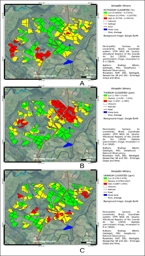
Figure 6 Zoning classification from contents of potassium (A), thorium (B) and uranium (C), “Santana do Livramento”, Brazil. Elaborated by the authors.
Radio-elements classes versus elevation classes
Nine classes were generated to each radio-element combining elevation classes for this analysis, as following:
Low elevation - low (K, Th, U);
Medium elevation - low (K, Th, U);
High elevation - low (K, Th, U);
Low elevation - medium (K, Th, U);
Medium elevation - medium (K, Th, U);
High elevation - medium (K, Th, U);
Low elevation - high (K, Th, U);
Medium elevation - high (K, Th, U);
High elevation - high (K, Th, U).
The distribution of radio-elements classes and their relationship with the elevation classes, along the vineyards area, can be seen in Figure 7 and their description, in Table 8.
For K, the highest values occurred in the medium and high elevations of the vineyard area, most of the average values predominate in the medium and high elevations and most of the low values of this element occur in mid-altitude terrain. For the Th element, most low, medium and high values occur in medium altitude of the vineyards. Regarding Uranium, in terms of the lowest, medium and high values, they also follow the average altitudes of the vineyard land. These relationships could indicate the variation of organic matter and the concentration of potassium, being able to monitor the vineyards with higher concentrations of these aspects.
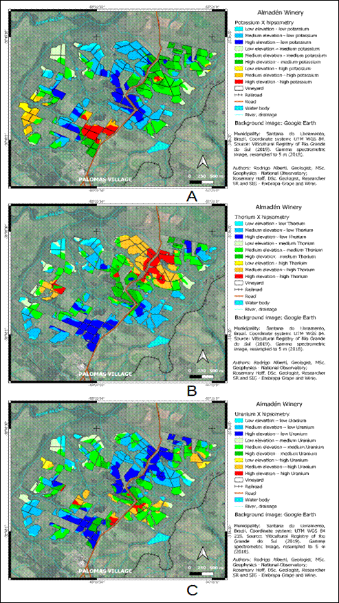
Figure 7 Crossing hipsometry map with maps of potassium (A), thorium (B) and uranium (C), at Almadén Winery, “Santana do Livramento”, Brazil. Elaborated by the authors.
Table 8 Crossing radio-elements maps versus hypsometry map at Almadén Winery, “Santana do Livramento”, Brazil. Elaborated by the authors
| Elevation (m) | Low (147.37 - 175) | Medium (175 - 200) | High (200 - 228.62) | Total (ha) | Total (%) | |||||
| Area (ha) | % | Area (ha) | % | Area (ha) | % | |||||
| Potassium | ||||||||||
| Low | 12.87 | 3.15 | 28.08 | 6.87 | 9.48 | 2.32 | 50.43 | 12.34 | ||
| Medium | 113.82 | 27.85 | 102.36 | 25.04 | 22.07 | 5.30 | 238.15 | 58.28 | ||
| High | 48.70 | 11.91 | 50.16 | 12.27 | 21.18 | 5.18 | 120.04 | 29.38 | ||
| Subtotal | 175.39 | 42.91 | 180.60 | 44.18 | 52.73 | 12.80 | 408.62 | 100 | ||
| Thorium | ||||||||||
| Low | 26.48 | 6.48 | 23.09 | 5.65 | 1.49 | 0.36 | 51.06 | 12.50 | ||
| Medium | 97.23 | 23.79 | 78.65 | 19.25 | 61.89 | 15.14 | 237.77 | 58.19 | ||
| High | 53.35 | 13.05 | 35.51 | 8.69 | 30.95 | 7.57 | 119.81 | 29.31 | ||
| Subtotal | 177.06 | 43.32 | 137.25 | 33.59 | 94.33 | 23.07 | 408.64 | 100 | ||
| Uranium | ||||||||||
| Low | 14.98 | 3.66 | 28.64 | 7.01 | 6.89 | 1.69 | 50.51 | 12.36 | ||
| Medium | 108.02 | 26.44 | 102.69 | 25.13 | 27.41 | 6.71 | 238.12 | 58.28 | ||
| High | 77.43 | 18.95 | 34.82 | 8.52 | 7.72 | 1.89 | 119.97 | 29.36 | ||
| Subtotal | 200.43 | 49.05 | 166.15 | 40.66 | 42.02 | 10.29 | 408.60 | 100 | ||
As shown in Table 8, the quantification of areas classified as low (147.37 - 175 m), medium (175 - 200 m) and high (200 - 228.62 m) altitude, compared to low, medium and high levels of radioelements Potassium, Thorium and Uranium, had behavior, sometimes similar, sometimes different in the vineyards of Almadén Winery, according to the approach of the data set.
Observing the individual values, Potassium showed the largest area (238.15 ha) with medium values, with the smallest area (9.48 ha) with low value at high altitudes and the largest area (113.82 ha) with medium value of this element at low altitudes. Thorium had the largest area (237.77 ha) with medium values, showing the smallest area (1.49 ha) with a low Th value at high altitudes and the largest area (97.23 ha) with an average value of this element at low altitudes. Uranium behaved in an area similar to the two elements K and Th, having a larger area (238.12 ha) with medium values. The smallest area (6.89 ha) had a low value at high altitudes and the largest (108.02 ha) had a medium value of this element at low altitudes. This similar behavior of K, Th and U contents along the altitude classes of the viticultural terrain suggests that the radioelements occur associated. Possibly, they were chosen in the higher portions of the farm, avoiding implantation in natural drainage areas, which are lower areas, avoiding humidity and possible accumulation of organic matter, as shown in Figure 3A. When observing the total areas of radioelements by altitude class, their behavior is different, and in the areas of high altitude class (200 - 228.62 m), where potential there would be better conditions for vineyards, Th predominated with 94.33 ha, while K and U occupied 52.73 and 42.02 ha, respectively. The medium altitude class (175 - 200 m) had the largest area for element K (180.60 ha), followed by Uranium and Thorium, which respectively presented total areas of 166.15 and 137.25 ha. The low altitudes of the vineyards (147.37 - 175 m) showed the largest area for the element Uranium (200.43 ha) and the elements K and Th, similar areas in this altitude range (177.06 and 175.39 ha). This suggests that Thorium may be more inert as it remained at the highest elevations, followed by K being less mobile but still migrating to middle parts of the vineyards and U being in the lower portions, suggesting greater mobility or migration on the soil surface.
According to Vos et al. (2006), the mobility of U in soil depends on that of the UO2 2+ cation, and the radio-element solubility is increased by the action of organic acids. When U is dissolved in water, it associates directly with OM, iron oxides and dissolved phosphates.
Kabata-Pendias (2000) highlights that from a geochemical point of view, Th has a behavior similar to U, having mobility dependent on Th4+. The solubility of this cation, over a wide pH range, accounts for its displacement. The solubility of Th increases when organic acids are present, however its mobility is impaired due to its precipitation, for example, in the form of phosphates and oxides.
According to Fráguas et al. (1996), an ionic antagonism can occur due to the excess of potassium which can cause the desiccation of the grape bunch, due to the lower absorption of calcium and magnesium. This corresponds to a physiological disorder that occurs at the beginning of the softening of the berries, characterized by the wilting of the ends of the bunches, which can progress to the rest of the bunch. Flores (2011) evaluated edaphic parameters in order to guide the implementation of the vineyards, about the K contents related to OM. If K is less than 1,5 ppm and OM less than 60 kg/ha, the soil is recommended for vineyard. (Table 9).
Table 9 Potassium contents and organic matter contents with respective recommendations according to Flores (2011)
| Potassium content (ppm*) | |
| ≤1.5 | very recommendable |
| 1.5-3.0 | recommendable |
| 3.0-5.0 | little recommendable |
| ≥5.0 | not recommendable |
| Organic matter content (kg/ha) | |
| ≤60 | very recommendable |
| 60-90 | recommendable |
| ≥91 | not recommendable |
| * Potassium content from chemical analysis | |
It should be explained that K gamma spectrometry measurements are in percentages, whereas U and Th are measured in ppm. However, soil chemical analyzes measure most elements in ppm, while measuring of gamma ray from K in % can only be an inference of the presence of K in the soil.
The lower contents of K provide better conditions for the establishment of vineyards, according Fráguas (1996). Thus, it is recommended to observe the areas with the lowest K content (0.066605784 - 0.175040764 %), correcting and monitoring areas with high contents, the South and Southwest of the vineyards (Figure 6A).
Dowdall and O'Dea (2002) observed that there was an increase in uranium along the profiles where the oxidation of organic matter was significantly reduced. Thus, it is assumed that higher U and Th contents would imply a lower amount of organic matter. So, it is recommended to monitor areas of high U content (0.68 - 1.058 ppm) as well as high Th content (3.20 - 4.26 ppm) to correct extreme values by periodic analysis of the soil, mainly during the phenological cycle, to correct extreme values in time.
It is suggested to carry out spectroradiometric analyzes, also a quick method of measurement, to complement the soil data in the region, confirming the presence of MO and iron oxides, in addition to other minerals, corroborating their influence on the behavior of radio-elements. In addition, the presence of different mineral species can be evaluated, in addition to other edaphic characteristics, such as granulometry, soil structure, surface roughness and humidity.
CONCLUSION
Radio-element content maps interpolated by the kriging method provided the geographic visualization within the vineyards of Almadén Winery. The zoning product of radioelement contents obtained by geoprocessing was compared with altimetry classes of the digital elevation model and related to soil units (Flores et al., 2007) and geology units (Wildner et al., 2008) .
Soil profiles indicate some uniformity in the Uranium and Potassium contents of the rock underlying the soil surface. For Thorium, enrichment was observed at some soil levels (Figure 5). This enrichment can be explained by the retention of the radioelement in the oxides and hydroxides of Fe and Ti in the sedimentary formation.
From the descriptive statistical values, it was observed that the levels of radioelements, despite not being very efficient for the differentiation of soil units in the study area, can give differences between the vineyards and relating them to potential levels of potassium and organic matter, very important for the vine.
From the radium element maps, some vineyards were indicated to be monitored as those containing the highest potassium content. The most favorable areas correspond to the lowest K and U values and the highest e Th values. The low content of K for vineyards was recommended by Flores (2011), the low presence of U indicates areas with low content of organic matter, as observed by Dowdall and O'Dea (2002).
Comparing the radioelement content classes with the altitude classes, even with little variability in both sets, it was possible to establish a predominance of elements K, Th and U, related to the relief of the vineyards and pointing out areas where monitoring is necessary. Thus, the lower areas, related to the predominance of Uranium, may have organic matter, as well as the medium altitude areas, where Potassium predominates, potentially unfavorable aspects for the vine. Higher altitude areas, where thorium is concentrated, may be more favorable to the vine, either because of the better drainage condition of the sandy soils, or because of the lower occurrence of K and U, always suggesting isolated areas with high concentrations of K and U for monitoring. (Figure 6A and 6C).
The possibility of establishing a zoning of K contents showed that gamma spectrometry can be an alternative to quickly measure the variations of this radioelement. This could point out areas with a greater probability of the occurrence of some physiological disorder related to its excess, such as the occurrence of diseases. As approached by Fráguas et al. (1996), there was drying of the rachis or drying of the bunch, characterized by wilting of the tips of the bunches, which could progress to the rest of the bunch.
The techniques used in this study can contribute to encourage the choice of areas for viticulture in the “Campanha Gaúcha” wine region, since there are extensive lands in the "Guará" Formation and similar soils in “Santana do Livramento” and other municipalities.

