


Serviços Personalizados
Journal
Artigo
 Inglês (pdf)
 Artigo em XML
 Referências do artigo
 Enviar este artigo por email
Indicadores
-
 Citado por SciELO
 -
 Acessos
Links relacionados
-
 Similares em
SciELO
Similares em
SciELO
Compartilhar

 Permalink
Revista de Gestão Costeira Integrada
versão On-line ISSN 1646-8872
RGCI vol.14 no.2 Lisboa jun. 2014
https://doi.org/10.5894/rgci484
ARTICLE / ARTIGO
Basis for the geological heritage management in the Azores Archipelago (Portugal)*
Bases para a gestão do património geológico no arquipélago dos Açores (Portugal)
Eva Almeida Lima@, I, II, III, João Carlos Nunes@, I, II, Manuel Paulino CostaII, IV, Marisa MachadoIV
@Corresponding author
IGeosciences Department,Azores University, Campus de Ponta Delgada, Apartado 1422, 9501-801 Ponta Delgada (Portugal), e-mails: Lima - evalima@uac.pt; Nunes - jcnunes@uac.pt
IIAzores Geopark [info@azoresgeopark.com], Centro de Empresas, Rua do Pasteleiro, s/n, 9900-069 Horta (Portugal), e-mails: Machado - marisamachado@azoresgeopark.com
IIIGeology Centre of the University of Porto, Rua do Campo Alegre 687, 4169-007 Porto (Portugal)
IVPico Island Natural Park, Regional Secretariat of Natural Resources, Lajido de Santa Luzia, 9940 São Roque do Pico (Portugal). e-mail: Costa - manuel.ps.costa@azores.gov.pt
ABSTRACT
The Azores archipelago, with a peculiar geodynamic setting, presents a huge geodiversity and important geological heritage, being considered a natural laboratory of volcanic geodiversity.
In the last decade, the geodiversity and geological heritage of the Azores archipelago is being inventoried, characterized, quantified, protected and promoted. Nowadays there are identified and characterized 121 geosites distributed through the nine islands and the surrounding seafloor. These geosites network ensure the representativeness of the Azorean geodiversity and reflects its geological and eruptive history with about 10 million years. Among the geosites, 57 were selected as priorities for the development of geoconservation strategies and implementation of promotion actions.
The analysis of the geosites included two main phases: a qualitative and a quantitative assessment, integrating the geological characterization, geomorphological and volcanological categorization, analysis of their relevance, identification of the potential type of use in each geosite, its scientific value and other associated values. The efforts resulted recognition of 6 geosites with international relevance [e.g. the Mid Atlantic Ridge, the Caldera of Furnas volcano (São Miguel island), the Pico Mountain (Pico island), the Caldera and Furna do Enxofre (Graciosa island), the Capelinhos volcano and Costado da Nau (Faial island) and Algar do Carvão volcanic pit (Terceira island)] and 52 geosites of national relevance. Besides its scientific value, most of the geosites have a relevant educational and geotouristic value. It is noteworthy that 93 geosites integrate the Regional Network of Protected Areas, lying under the management of the Island Natural Parks and the Marine Park.
The volcanic landscapes of the Azores have been promoted since the late twentieth century, especially for tourism campaigns, however since the begining of the work studies of the geological heritage of the archipelago in 2007, has also been promoted regionally, nationally and internationally.
Keywords: geological heritage, geoconservation, management, Azores Geopark.
RESUMO
O arquipélago dos Açores, com um enquadramento geodinâmico singular, apresenta uma enorme geodiversidade e importante património geológico, sendo considerado um laboratório natural de geodiversidade vulcânica.
Nos últimos anos têm vindo a ser desenvolvidos estudos e ações de valorização do património geológico do arquipélago, estando, atualmente, identificados e caracterizados 121 geossítios distribuídos pelas nove ilhas e fundos marinhos envolventes, que garantem a representatividade da geodiversidade dos Açores e reflectem a sua história geológica e eruptiva de cerca de 10 milhões de anos. Destes, 57 geossítios foram selecionados como prioritários para o desenvolvimento de estratégias de geoconservação e para implementação de ações de valorização.
A análise dos geossítios incluiu duas fases principais: uma avaliação qualitativa e uma avaliação quantitativa, integrando a caracterização geológica, categorização geomorfológica e vulcanológica, análise da relevância, a identificação do potencial tipo de uso em cada geossítio, seu valor científico e outros valores associados. Dos trabalhos desenvolvidos resultaram o reconhecimento de 6 geossítios com relevância internacional [e.g. Dorsal Atlântica, a Caldeira do vulcãodas Furnas (ilha de São Miguel), a Montanha do Pico (ilha do Pico) a Caldeira e Furna do Enxofre (ilha Graciosa), o Vulcão dos Capelinhos e Costado da Nau (ilha do Faial) e o Algar do Carvão (ilha Terceira)] e 52 geossítios de relevância nacional. Para além do valor científico, a maior parte dos geossítios têm valor educacional e geoturístico. É de salientar que 93 geossítios integram a Rede Regional de Áreas Protegidas, encontrando-se sob gestão dos Parques Naturais de Ilha e do Parque Marinho dos Açores.
As paisagens vulcânicas dos Açores têm vindo a ser promovidas desde o final do século XX, principalmente por campanhas turísticas, contudo desde que se iniciaram os trabalhos de estudos do património geológico do arquipélago, em 2007, este também tem vindo a ser divulgado regional, nacional e internacionalmente.
Os geossítios terrestres estão a ser monitorizados, incidindo-se no estado do geossítio, suas condições geológicas de interesse e na caracterização do público que o visita. A monitorização iniciou-se no final de 2013 em todo o arquipélago, aguardando-se os primeiros resultados para o final do ano de 2014.
Palavras-chave: património geológico, geoconservação, gestão, Geoparque Açores.
1. AZORES ARCHIPELAGO
The Azores archipelago is a Portuguese autonomous region located in the Atlantic Ocean (at a distance of 1815 km from Portugal mainland and 2625 km from Canada), composed by nine islands (with small dimension, between 17 and 745 sq. km), some islets and the surrounding seafloor. The islands are dispersed along approximately 600 km, between Santa Maria and Corvo islands, with an orientation WNW-ESE (Figure 1).

The Azores archipelago emerges from an extensive area of irregular bathymetry, defined by the 2000 meters bathymetric line, which makes the transitions to the surrounding abyssal seafloor.
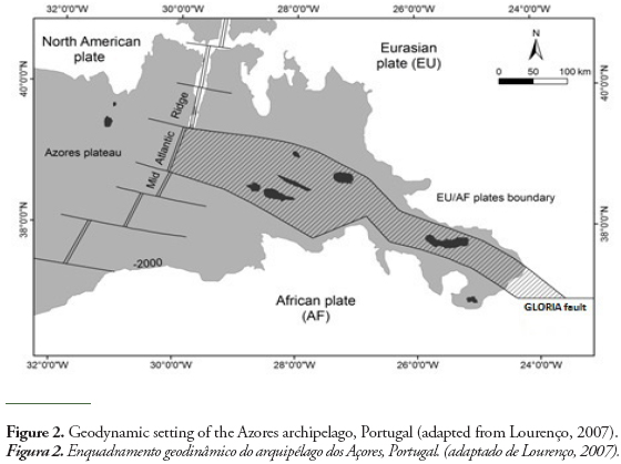
In terms of the global geodynamics, the archipelago is located at the triple junction of the Eurasian, North American and African (or Nubian) lithospheric plates. The main structures that frame this junction are: i) the Mid-Atlantic Ridge (with an approximately N-S trend) - which corresponds to a pure distensive boundary between the North-American plate, on West, and the Eurasian and African plates, on East, and ii) the Gloria Fault (with a general W-E trend), that establishes the plate boundary Eurasia-Africa and integrates a major structure, the Azores-Gibraltar Fault.
The configuration of the islands of the central and eastern groups, with west-northwest - east-southeast, and Corvo and Flores islands through north-south direction, reflects the structural control by the main tectonic structures that interact at the Azores triple junction and influence the geomorphology of the islands (Nunes., 1991; França et al., 2003;. Nunes et al., 2009)(Figure 2).
All the Azorean islands are of volcanic origin, being identified 16 polygenetic volcanoes and 11 fissural volcanic systems, counting with a total of 1750 monogenetic volcanoes in the archipelago (Nunes & Lima, 2008). Given its complex geodynamic framework the Azores archipelago also presents an important seismicity on a global context, related either with the active tectonic activity in the Azores, either to the occurred volcanic activity.
The Azores archipelago has a rich and vast geodiversity and an important geological heritage, composed by several sites of scientific, educational and touristic interest. Volcanoes, calderas, lakes, lava fields, fumaroles, hot springs and thermal waters, volcanic caves, “fajãs”, fault scarps and marine fossil deposits, among many others, are characteristic elements of the Azorean geological heritage.
The volcanic features toghether with the tectonic, paleontological and others, were the starting point for the identification, characterization and quantification of the value of the geodiversity and geological heritage of the Azores (Lima, 2007;. Nunes et al., 2011).
2. NATURE CONSERVATION IN THE AZORES ARCHIPELAGO
Since the settlement of the Azores, in the middle of the 15th century, the exceptional natural and landscape resources attract several visitors and distinguished naturalists and scientists. However nature conservation in the Azores becomes effective in 1972 with the creation of the first protected areas, the Integral Reserves of Faial Caldera and Pico Mountain (Decreto Legislativo n.º 78/72, de 7 de março, e Decreto Legislativo n.º 79/72, de 8 de março) (Lima, 2007).
After Goulart (1999), the main strategic actions in the archipelago in the conservation of nature are related to:
- the application of national law;
- the appropriateness of the legislation to the archipelagic specificities, from political-administrative status as an autonomous region;
- implementation of the regional ecological network;
- cataloging the natural heritage of the Azores;
- the implementation of measures for the development and management of classified areas;
- the allocation of a environmental monitoring staff (the nature guards);
- the promotion of information and dissemination campaigns about the natural heritage;
- encouraging the development of the scientific knowledge;
- the establishment of inter-regional, national and international projects of intersectoral cooperation.
Regarding the geological component of the Azorean natural heritage, the oldest descriptions of the geology of the islands were writen by Gaspar Fructuoso in the 16th century (Fructuoso, 1583; França et al., 2003). However, only in the second half of the 20th century is introduced the concept of conservation of the geological heritage elements in the region with Victor Hugo Forjaz as a pioneer (Forjaz et al., 2006; Forjaz, 2007; Lima, 2007).
The Environmental management in the archipelago, made in recent years, reflects the increased concerns safeguarding the rich geological heritage of the region, contributing also to their promotion and enhancement. Lima (2007) indicates several important steps to achieve this objective, presented in the following list:
- the opening to the public of some volcanic caves, such as Furna do Enxofre on the Graciosa island since 1939, the Algar do Carvão and Gruta do Natal at Terceira island since 1968 and 1969 respectively, and more recently, the Gruta das Torres in Pico island, Gruta do Carvão in São Miguel island, and showing part of the volcanospeleological heritage of archipelago;
- in 1998 the Azores Regional Government creates a multidisciplinary group to study the volcanic caves of the archipelago and their management, designated GESPEA;
- the Volcanological and Geothermal Observatory of the Azores, created in 1998, edited several publications for the dissemination and promotion of the geological heritage of the region; this institution has also promote public actions of geological education;
- some Azorean environmental non-governmental organizations (e.g. Amigos dos Açores - Ecological Association and Os Montanheiros - Speleological Society), also participate in the dissemination and promotion of the geological component of the natural heritage of the archipelago, through publications, proposed classification of geological interest sites, and recreational activities that promote the contact with the natural heritage;
- the volcanospeleological museum, opened to the public since the 1980’s, property of Os Montanheiros – Speleological Society (Terceira island);
- the classification of some geosites as Natural Monuments in 2004 and 2005, such as Pedreira do Campo in Santa Maria island, Gruta do Carvão, Pico das Camarinhas and Ponta da Ferraria in São Miguel island and Gruta das Torres in Pico island, although there are other geological elements protected under others legal figures since 1972;
- in 2004 the project “GeoDIVA - Geodiversity of Protected Areas of the Azores” was implemented by the Azores University, providing scientific advice to the Environment Regional Directorate of the Azores Regional Government, regarding the promotion and enhancement of the geodiversity of these areas;
- several studies about the geodiversity and geological heritage of the Azores have been developed, such as publications about the Azores islands of geodiversity - Graciosa, Santa Maria and São Jorge islands (Nunes & Lima, 2005; Nunes et al., 2007; Lima et al., 2013a), Geosites Maps - Santa Maria, Graciosa, Corvo and São Jorge islands (Nunes et al., 2008; Nunes et al., 2009; Nunes et al., 2010; Nunes et al., 2013);
- there are also some academic studies and works on these topics, such as master’s theses “Azorean Geologic Heritage: Valuing Geosites in Environmental Classified Protected Areas, Contribution to the Territorial Planning” (Lima, 2007), “Monitoring Strategies for the geosite ‘ Ponta da Ferraria e Pico das Camarinhas’, S. Miguel Island: Contribution to the sustainable management of the geological heritage of the Azores Geopark “(Lima, 2012) and a degree thesis about “Geomonuments Map of Terceira Island (a contribution)” (Lopes, 2007);
- participation in dissemination sessions about the geodiversity and geological heritage of the Azores in regional, national and international events, providing information about the work in progress and sharing experiences;
- in 2007 the Azores Regional Government announced its intention to create the Azores Geopark and submit its application to the European and Global Geopark Networks; in 2010 it was formally established the Azores Geopark Association, which manages the geopark; and in march 2013 occurred the inclusion in the networks, constituting the first archipelagic geopark, and thus being internationally recognized the value of their geological heritage and its importance in the social, cultural and economic dynamics of this region.
It is worth to note that the Regional Legislative Decree n. 15/2007/A, of 25 June, which reclassifies the protected areas of the region with uniform criteria, integrates, for the first time in regional and national environmental legislation, geological elements of the Azorean geodiversity (beyond those associated with biological aspect).
Therefore since the last decades of the 20th century there have been some initiatives that show concern for the protection of geological heritage of the archipelago, having stepped up the number of activities and studies for this purpose. As mentioned above, the geological heritage of the archipelago has its value, recently, recognized with the creation of the Azores Geopark.
3. GEOCONSERVATION IN THE AZORES ARCHIPELAGO
The set of strategies, policies and actions for an effective conservation of the geodiversity and geological heritage protection is called geoconservation (Sharples, 2002; Brilha, 2002, 2005; Gray, 2004).
The geoconservation is based on a working methodology that systematizes the tasks in the conservation of the geological heritage of given territory (Brilha, 2005). Some authors describe methods of work with that purpose, based generally on the same basic steps (Cendrero, 2000, Lago et al., 2001; Brilha, 2005; Carcavilla et al., 2007).
In general terms the steps to apply are:
- inventory and characterization - each geosite must be located and limited geographically, and characterized based on field work and bibliography;
- quantification of the value or relevance - calculated based on defined criteria;
- classification - the geosites that obtain greater importance should be proposed for classification in accordance with the existing legal framework;
- conservation - a geoconservation strategy should give concrete and practical answers to a preliminary assessment on the threats that may relate to the geosites;
- valorization and promotion - actions of information and interpretation that help the public to recognize the value of the geosites;
- monitoring - verification and analysis of the evolution of the geosites conservation, to ensure the maintenance of its value and relevance.
3.1. Inventory and characterization
The inventory and characterization of the geological heritage of the Azores was based on three studies: i) a Master thesis in Spatial and Environmental Planning at the Azores University, Azorean Geologic Heritage: Valuing Geosites in Environmental Classified Protected Areas, Contribution to the Territorial Planning by Lima (2007); ii) the works and studies leading the Azores Geopark application to the European Network and Global Geoparks (Nunes et al., 2011); iii) and the scientific research project Identification, characterization and conservation of geological heritage: a geoconservation strategy for Portugal (2007-2010) (Brilha & Pereira, 2012).
3.1.1. Master thesis - Lima (2007)
The first systematic study of the geological heritage of the archipelago was carried out by Lima (2007). The analysis of the geological heritage of the 83 environmental areas classified in the Azores included two main steps: a qualitative and quantitative assessment.
The geological characterization of each environmental area and the selection of the sites that stand out for its geological features were based on the geological knowledge of the areas complemented with bibliography research, resulting in the identification of 59 geosites (56 terrestrial and 3 marine) (Figure 3).
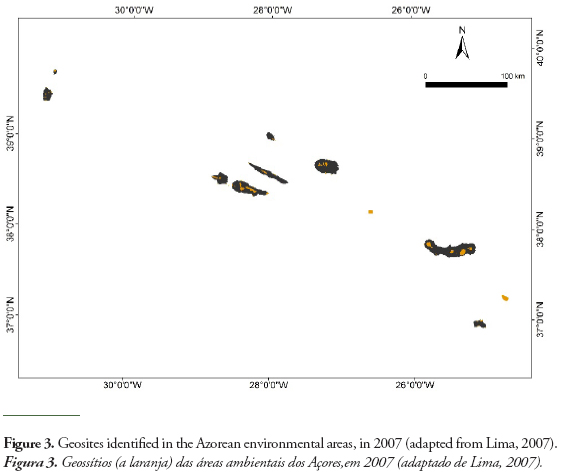
Following the characterization of the geosites, these were categorized according to their geomorphological and volcanological characteristics, being based on the work performed by Nunes (2003).
According to the results obtained most of the geosites identified are coastal and marine areas (25), several altitude areas (19) and many integrate volcanic lakes or coastal lagoons (15), reflecting the morphological character of the islands, usually with a mountainous central zone and with great presence of water. In the remaining categories, we report the historical eruptions (13), areas of hydrothermal activity (10), calderas (9), surtseyan tuff cones (6), volcanic caves (4) and fields of scoria and spatter cones (3), portraying the diversity of morphologies and types of volcanic activity that gave rise to them.
About the quantitative assessment, Lima (2007) opted to adapt the methodology of Brilha (2005) to the territorial and geological reality of the archipelago. It is noted that the above method is based on the method described by Cendrero et al. (1996) and Cendrero (2000), but adjusted to the Portuguese reality. In this methodology three classes of criteria about the geosites are evaluated: A) intrinsic criteria (uniqueness, area, geodiversity, conservation status, association with other heritage elements, scientific knowledge), B) potential use (observation conditions, accessibility, potential audience, socio- economic conditions, different types of use) and C) need for protection (legal status, ownership, vulnerabilities and threats). Calculated the relevance or value of the geological heritage assigning numerical values to different criteria, allowed the comparison among the analyzed geosites, resulting the ranking and determining their international/national or regional/local relevance.
In the 59 geosites identified in the existing environmental areas of the Azores in 2007, 36 had international or national importance, and the other 23 had regional or local relevance. It was also found that the most valued sites are those that include a remarkable geodiversity. In the ranking the most importants sites are Caldeira do vulcão das Furnas (Furnas volcano caldera), on the island of São Miguel; Montanha do Pico (Pico Mountain); Caldeira do Faial (Caldera of the central volcano of Faial island); Caldeira do vulcão das Sete Cidades (Sete Cidades volcano caldera) and Caldeira do vulcão do Fogo (Fogo volcano caldera) both also in São Miguel.
3.1.2. Azores Geopark aplication to the European and Global Geoparks Networks
The inventory and characterization of geological heritage has been extended to the entire archipelago with the same methodology of Lima (2007), this analysis was crucial to the application of the archipelago internationally recognized as a geopark.
The developed works were based on the knowledge gathered about the geological characteristics of the territory, the eruptive history of each Azorean island and the elements of geological heritage identified in the islands and in the surrounding seafloor. Several researchers of the Region and national and foreigner scientists with assignments about the Azores in several areas have also contributed to this inventory, which have resulted in a sustained and wide approach (Nunes et al., 2011).
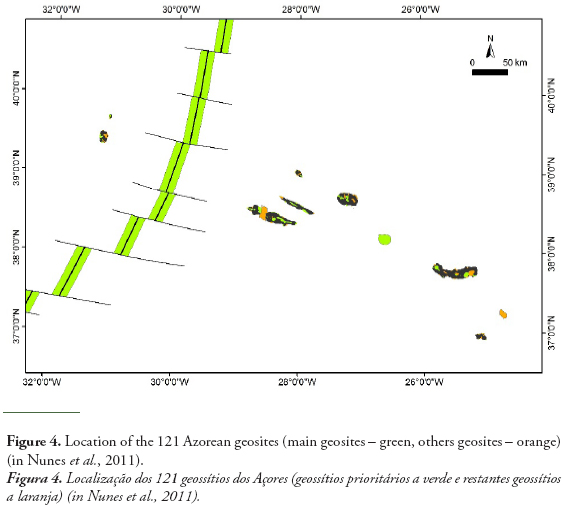
The geopark is based on a network of 121 geosites spread over the nine islands and the surrounding seafloor (Figure 4) which ensures the representativeness of the geodiversity of the Azores and reflects its geological and eruptive history of about 10 million years. From these, 57 geosites were selected as priority for the development of geoconservation strategies and for the implementation of valorization actions at the aim of the project Azores Geopark, distributed by Santa Maria (5), São Miguel (10), Terceira (7), Graciosa (5), São Jorge (5), Pico (8), Faial (6), Flores (6) and Corvo (3) islands, and the Azores Plateau seafloor (2) (Lima et al., 2009; Nunes et al., 2011).
The choice of priority geosites relied on several parameters: i) the international or national relevance; ii) representativeness of the archipelago geodiversity; iii) its position in the geosites ranking; iv) category icons and v) characterization (vulnerability, usufruct, affluence, ...).
Qualitative and quantitative assesment were also performed, based on Lima (2007), incorporating not only the geological characterization, geomorphological and volcanological categorization and analysis of the relevance, as well as identifying the type of use in each geosite, its scientific value and others associated values. The geosites list and the most relevant results are presented in the Table 1 to 3.
The geosites were grouped in categories according to their geomorphological, geological and volcanological characteristics, having adopted the previous categorization performed by Lima (2007) and detailing aspects of volcanic morphology according the classification of Wood (2009). So 23 geomorphological and volcanological categories were established, highlighting sea cliffs, polygenetic volcanoes with caldera, volcanic caves, prismatic and spheroidal jointing, historical eruptions, sub-volcanic structures (e.g. necks and dykes), fluvial valleys and areas of hydrothermal activity, confirming the archipelagic and volcanic nature of the territory.
In the analysis of the geosites relevance it was applied the same quantitative methodology of Lima (2007), but distinguished themselves in geosites with international relevance (6 geosites), national relevance (52 geosites) and regional relevance (63 geosites). The geosites of international relevance are: the Dorsal Atlântica e Campos hidrotermais (Mid-Atlantic Ridge and deep-sea hydrothermal fields), as it is a global tectonic boundary; the Caldeira do vulcão das Furnas (Furnas volcano caldera) (São Miguel island), which besides being a volcano-lab, has an important hydrothermal and hydrological system (mineral, thermal and CO2-spring gas waters) richness; Montanha do Pico (Pico Mountain polygenetic volcano), because is the 3rd highest central volcano on North Atlantic; the Caldeira e Furna do Enxofre (Graciosa volcano caldera and Furna do Enxofre volcanic cave) (Graciosa island), by its size, shape and genesis of the volcanic cave; Vulcão dos Capelinhos e Costado da Nau (Capelinhos volcano and Costado da Nau volcano) (Faial island), due to the relevance of the Capelinhos eruption for volcanology science; and Algar do Carvão volcanic pit (Terceira island), because it includes the top ten worldwide volcanic cave in terms of mineral deposits (silica speleothemes) (Nunes et al., 2011) (Figure 5).
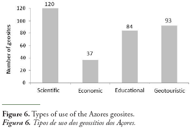
Most geosites are used for scientific studies, also being realized in most of them geotouristic and education activities. In about one third of the geosites occur economic activities directly related to the geology of the site, either through paid visits to the geosites (e.g. volcanic caves), either by quarries or geothermal energy production (Figure 6).
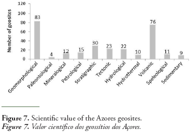
The scientific value of each geosite was decomposed in different geological areas, verifying that the main types of scientific values expressed by the Azorean geosites are in terms of geomorphology and volcanology, as it is expected in a volcanic archipelago (Figure 7).
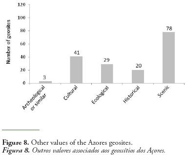
The geological heritage is sometimes associated to other types of heritage, valuing them, and in some cases, complementing them. Most of the Azorean geosites have associated other value types, being the most common the scenic, cultural (highlighting the close relationship between the Azorean people and their volcanoes), and ecological (several geosites are the substrate and create conditions for the existence of important habitats and ecosystems) (Figure 8).
An analysis made to the 117 geosites of the insular territory, having in account the related urban and industrial pressure, has shown that 54% of the geosites present a reduced actual or potential pressure and only 10% (12 geosites) are subject to a high urban pressure. Concerning the vulnerability to human interventions, in 10 geosites (e.g. volcanic caves, Fountain of Ribeira Seca, in São Miguel island, and the coastal lagoons associated to the Lajes do Pico lava delta, in Pico island) several elements of geodiversity may be destroyed even by little anthropic interventions or by small structures of easy depreciation. In an opposite way, 86 geosites present geomorphological aspects or large geological structures that, by its dimensions, relief, etc., are hardly affected, in a significant way, by the anthropic activities, or its destruction is not likely to happen (Nunes et al., 2011).
Considering the vulnerability to the natural evolutionary processes of the geosites (e.g. erosive actions, cliff retreats, fauna activity, vegetation growth), only two geosites are under high pressure, due to the marine erosive processes (Pisão – Praia, at Água dAlto, São Miguel island) and the vegetation growth (Capelinhos and Costado da Nau, Faial island) (Nunes et al., 2011).
3.1.3. Scientific research project “Identification, characterization and conservation of geological heritage: a geoconservation strategy for Portugal” (2007-2010)
Additionally, there was an evaluation of the scientific value of the 121 geosites in the Azores archipelago and of its degree of vulnerability, taking into account the criteria commonly used in several European countries. This evaluation took place in the context of the research project Identification, characterization and conservation of geological heritage: a geoconservation strategy for Portugal, funded by the FCT - Foundation for Science and Technology (2007-2010), which sought to implement, in whole Portuguese territory, a methodology for the inventory and the classification of geological heritage, from the perspective of its geoconservation, valorization and dissemination (Brilha et al., 2006; Brilha & Pereira, 2012). This analysis assigned numerical values to various criteria such as uniqueness, recognition as a local standard, scientific knowledge, integrity, diversity and rarity. The obtained results confirmed the relevance of the main geosites already mentioned from the previous methodologies: the Mid-Atlantic Ridge and deep-sea hydrothermal fields, followed by the Caldera of Furnas silicic polygenetic volcano (São Miguel island), Pico Mountain polygenetic volcano (Pico island), Graciosa volcano caldera and Furna do Enxofre volcanic cave (Graciosa island), and the Capelinhos volcano and Costado da Nau volcano (Faial island).
The vulnerability of the 121 geosites was evaluated under the same project - using criteria such as the possibility of deterioration of the geological content, the proximity to potentially degrading areas, accessibility and population density - resulting in 10 geosites with high vulnerability (e.g.quarries - Pico Timão, Graciosa island, or urban pressure - Fajã lávica e arriba fóssil da Caloura, São Miguel island), while the remaining geosites present a moderate vulnerability (63%) or low (29%) (Nunes et al., 2011).
3.2. Classification
Currently a significant number of the Azores geosites (93 geosites) are under legal protection of the Island Natural Parks and the Azores Marine Park. Additionally several geosites are covered by other classifications and protection and enhancement measures such as Natura 2000 Network, Ramsar, OSPAR, Important Bird Areas, and some also integrate classified areas as UNESCO World Heritage sites (e.g. the Historical Centre of Angra do Heroísmo, Terceira island, and Landscape of the Pico Island Vineyard Culture), or Biosphere Reserves of Graciosa, Flores and Corvo islands. Although there are 19 geosites without any legal classification or protection (Nunes et al., 2011).
But it was not always like this, though in 1972 the first sites of geological interest were classified (as mentioned above: Pico Mountain and Caldeira from Faial island), they were not protected for its geological features, happening the same with others 50 now recognized as geosites, that were classified essentially by their biological and/or ecological factors, and others few (22) were classified by geological and biological or ecological factors abreast (Lima, 2007).
This change happened with the contribution and cooperation of the technical staff of the Azores Geopark in the reviewing of the protected areas performed, in recent years, under the 15/2007/A Regional Legislative Decree, of 25 June.
3.3. Valorization and promotion
The Azores geological heritage has been promoted and disseminated since the beginning of its studies in 2007 (Lima et al., 2012), although the Azorean geolandscapes are promoted since the late 20th century, mainly through tourism campaigns at national and international levels. However, it has been a lack of information and promotion in the archipelago itself, so that the Azorean people can be aware of the value and importance of their geosites often used in the daily and leisure activities.
As it use to say people only value what they know and with this purpose several promotional and informational products of the Azores geological heritage have been developed, directed to: i) the general public (a newspaper page published every two weeks Geodiversidades in the newspaper with largest circulation in the archipelago - Açoriano Oriental, leaflets and brochures about the geosites and the Azores Geopark, the web page and the participation in social networks and newsletters), ii) to the student audience (through the educational programs of the Azores Geopark, the Childrens Guide Volcanoes of the Azores, some games and activities development in the school context or at study visits), and iii) the specialized geological heritage public (through the participation in national and international events on geological heritage, geoparks and geotourism or projects with other specialists) (Lima et al., 2012).
Several partners of the Azores Geopark also contribute to the dissemination of the value and importance of the Azorean geosites, either through his explanation at the Environmental Interpretation Centres or the Science Centres or through the geological heritage usufruct with tourism companies.
A community informed will value its geological heritage and ensure a greater commitment to its conservation (Lima et al., 2012).
3.4. Monitoring
Monitoring ensures a better conservation of geological heritage and improves the management practiced in a given geosite (Lima, 2012).
The first monitoring plan applied to a geosite in the archipelago was carried out by Lima (2012) at the Ponta da Ferraria e Pico das Camarinhas geosite (São Miguel island), from October 2011 to October 2012, with the goal to identify the threats that endanger the integrity of the geosite and to quantify the gains or loss of relevance that it has suffered over time due such threats. It was made a direct count of the number of visitors, observation of their behavior and questionnaires were administered.
By observing the behavior adopted it was found that most visitors follow the rules, and only a minority goes out the marked trails or ride motorized vehicles outside the proper areas; it appears however that the accumulation of waste is a problem, also due to ineffective collection performed. By the questionnaires analisys it is know that most of the public want to spend 1-2 hours on this place and are interested in knowing it better, so it is justified to bet on additional measures and specific interpretation [being indicated by Lima (2012): a geodiversity interpretation trail, production of interpretive brochures and creating a visitants centre]. With the count of visitors it was concluded that about 72,000 people visit this geosite per year, being 850 the highest number of visitors recorded in a day, but not reaching the load capacity calculated for geosite, which is 2050 visitors a day (Lima, 2012).
At the end of the year 2013 began the experimental monitoring of the Azores geological heritage with several tests in Faial, Pico, Terceira and Santa Maria islands, reaching at a final monitoring checklist to be applied systematically in all terrestrial geosites of the archipelago. It includes parameters such as: the geosite status (cleanliness, accessibility, signage), its geological conditions of interest (conservation, threats, natural evolution) and the characterization of the public.
Given the geosites number and their dispersion in the archipelago, this monitoring counts with the cooperation of the Nature Vigilants of the 9 Island Natural Parks (Azores Geopark partners), with a periodic verification by the technical staff of the geopark. The first results and conclusions are expected at the end of 2014, after monitoring throughout the calendar year, covering different seasons and inherent changes in natural conditions, and high and low visitation seasons.
In the work plan is also set for 2015 start the monitoring of the submarine part of the coastal geosites and even the submarine geosites, also relying on the stablished partnerships for this purpose (e.g. regional diving companies and the Oceanography and Fisheries Department of the Azores University.
4. ANALISYS OF THE INTEGRATION OF GEOHERITAGE IN THE ENVIRONMENTAL AND LAND-USE POLICIES
The analysis of the integration of the geological heritage in environmental and use policies of the archipelago was made by Lima (2007), checking the inclusion of this issue in key strategic and operational instruments and documents.
All documents considered (32) integrate a nature conservation component, but only 9 explicit the geological component in their policies for the conservation and valorization of nature, and of these, only 6 used the appropriate nomenclature of the subject. There is also the note that the instruments surveyed are more indicative than operating, regarding the topic of geological heritage.
In 2013, Lima et al. (2013b) returned to do this analisys, and this time from the 49 planning instruments analyzed (with 21 new documents for environmental and land use planning implemented), 16 included a geological component of the natural heritage. Then it appears that although the main strategic and operational tools integrate existing nature conservation, only about a third (the same proportion as in 2007) of these refer their geological component, verifying that there is still much to do to raise awareness of the work teams of spatial planning concerning this subject.
5. GEOLOGICAL HERITAGE USUFRUCT
The Azorean people learned to live with its volcanoes and earthquakes, taking advantage of the fertile soils, the geological resources and beautiful landscapes to promote their socioeconomic development.
The relationship human/geodiversity marks the daily life of the Azorean society, namely: the regional architecture (popular, religious and military) with the use of local ornamental rocks; religious events (pilgrimages, processions and the Holy Spirit festivities) closely related to the occurrence of natural events (volcanic eruptions and earthquakes); the traditional enjoyment of secondary manifestations of volcanism through baths in thermal pools, the use of mineral and CO 2-sparkling waters, the use of mud as peloids and the degustation of food that is steamed in the fumarolic field of the Furnas Volcano; toponomy like Lajedo, Lajidos, Biscoitos and Mistérios, among other geological names used on the islands as well as in geoproducts as in the case of wines such as Terras de Lava, Basalto, Magma or Pedras Brancas, and even on Azorean stories and legends (Nunes et al., 2011).
The Azoreans geolandscapes also assume the main motto of interest and development of nature tourism in the archipelago and feature a wide range of possibilities for sustainable use , where it can be practice different activities and develop associated tourism products, such as the geotourism through walking trails and trekking, volcanic speleology, geotours, and hydrotherapy among others. The Azores geotourism is also supported on different thematic routes that promotes the region based on the volcanism and the geolandscapes: i) the volcanic caves route; ii) the belvederes route; iii) the walking trails route; iv) the thermal route; v) the science and interpretation centres route, vi) urban routes and vii) litoral routes (Machado et al., 2013). It is noteworthy that besides the contribute to the socio-economic development mainly in rural areas, these products have highlighted the importance of the geotourism as a tool to promote and preserve the geological heritage of the Azores, turning, also, as an important instrument of environmental awareness through the local and foreign people (Lima et al., 2013).
6. GEOLOGICAL HERITAGE MANAGMENT
The Azores geological heritages constitutes an ex-libris of the archipelago and is an important resource that must be promoted and used in a sustainable way. To reach this goal a good management of the recreational, educational and tourism uses should coexist with a geoconservation policy (Lima et al., 2013b).
There are several papers about inventory methodologies for geological heritage and its scientific, educational and tourism uses, however, management methodologies for geological heritage are still poorly developed. They should be included in environmental and land-use planning and nature conservation policies, in order to support a holistic approach to natural heritage. This gap is explained by the fact that geoconservation is a new geoscience and still need of more basic scientific research, like any other geoscience (Henriques et al., 2011).
Also in the Azores, despite the developed works on the inventory, characterization and monitoring of the geological heritage, there isn’t an integrated planning for their management. Also lacking studies to identify threats and to propose guidelines for their sustainable management that constitute basic tools to an adequate geoconservation (Caetano & Lima, 2005).
Lima (2007) refers some existing management measures and informal management plans for some geosites:
- as verified in the previous analysis, most of the Azorean geosites are integrated in the Island Natural Parks and other legal figures, being subjected to its management measures;
- some geosites have load capacities defined, such as the Vila Franca do Campo islet, São Miguel island (400 visitors per day), and Pico Mountain (160 visitors simultaneously and 40 people in Piquinho per 30 minutes);
- some geosites have restricted access and their visitation is controlled, as in Caldeira from Faial Island and the volcanic caves with guided tours (Gruta do Carvão in São Miguel island, Gruta das Torres in Pico Island, Furna do Enxofre in the Graciosa island, Algar do Carvão and Gruta do Natal in Terceira island) with load capacities also defined.
Then becomes necessary to establish mechanisms and protocols targeted for conservation and management of geological heritage. This management is complex because it serves not only the natural features and aspects, seen from a scientific perspective, but also legal, economic, cultural, educational and recreational aspects, also taking into account the variety of natural and anthropogenic (Lima et al., 2013b).
With the integration of the archipelago in the European and Global Geopark Networks increases the challenge and reinforces the commitment of the management of its geological heritage.
A PhD in Environmental Geology about the “Definition of a methodology for the management of geological heritage. An application to the Azores archipelago” is being developed in the Azores University, under which it is intended to investigate, evaluate and define a methodology for the management of the geological heritage, with a view to mainstreaming of spatial and environmental planning. The application to the Azores is expected to set management measures to the proper functioning of the geosites and better enjoyment by those who visit or use them daily.
7. CONCLUSIONS
The Azores archipelago, despite its small territorial dimension, presents a wide range of morphologies, rocks and structures, arising, among other factors, from the nature of the magmas, the type of eruption that originated, its dynamics and the subsequent action of external agents, such as the hydrosphere, atmosphere and biosphere. The expression of this geodiversity is reflected in volcanic calderas, lava fields, volcanic ridges, volcanic lakes, prismatic jointings, etc.
The geodiversity of the Azores islands, along with other determinants factors as their size, dispersion, geographic location and climate, are responsible for distinctive ecological conditions, which translate, in a unique way, the close relationship between the geodiversity and biodiversity of the archipelago.
There have been developed, in recent years, studies and actions of inventory, characterization, classification, valuation and monitoring of geological heritage and there are currently identified and characterized 121 geosites (117 terrestrial geosites and 4 marine geosites), with high relevance (6 of international relevance, 52 of national relevance and the others with regional relevance), some protected (93), some vulnerable (22), and almost all with usufruct by the Azoreans and visitors.
Interpretation and dissemination resources about the geological heritage were produced, and developed awareness and promotion activities with the general public and the school population.
It is also noteworthy that the identified geosites have been taken into account in the recent environmental and land use planning policies and in the review of the protected areas of the archipelago.
It is missing to manage systematically the geological heritage, defining measures for a proper management of each geosite.
So, now that the inventory, characterization and evaluation of the Azorean geological heritage are done, are created the bases to work on a management methodology of geological heritage of the archipelago, which given their characteristics (size, dispersion of the islands and its genesis), may also be adapted later to other Macaronesian archipelagos (Madeira, Canary and Cape Verde).
ACKNOWLEDGMENT
This work is a contribution to the doctoral research project “Definition of a methodology for the management of geological heritage. An application to the Azores archipelago (Portugal)”, Ref. M3.1.2/F/033/2011, supported by the Science Regional Fund of the Azores Government, and co-financed by the European Social Fund through the EU Pro-Employment Program.
REFERENCES
Brilha, J. (2002) - Geoconservation and protected areas. Environmental Conservation, 29(3):273-276. DOI: 10.1017/S0376892902000188
Brilha, J. (2005) - Património geológico e geoconservação: a conservação da natureza na sua vertente geológica. 190p., Palimage Editores, Viseu, Portugal. ISBN: 9728575904
Brilha, J.; Pereira, P. (coord.) (2012) – Património Geológico / Geological Heritage. Geossítios a visitar em Portugal / Geosites to visit in Portugal. 144p., Porto Editora, Porto, Portugal. ISBN: 978-9720320087
Brilha, J.; Andrade, C.; Azeredo, A.; Barriga, F.J.A.S.; Cachão, M.; Couto, H.; Cunha, P.P.; Crispim, J.A.; Dantas, P.; Duarte, L.V.; Freitas, M.C.; Granja, H.M.; Henriques, M.H.; Henriques, P.; Lopes, L.; Madeira, J.; Matos, J.M.X.; Noronha, F.; Pais, J.; Piçarra, J.; Ramalho, M.M.; Relvas, J.M.R.S.; Ribeiro, A.; Santos, A.; Santos, V.F.; Terrinha, P. (2006) - Definition of the Portuguese frameworks with international relevance as an input for the European geological heritage characterisation. Episodes (ISSN: 0705-3797), 28(3):177-186, International Union of Geological Sciences, Washington, DC, U.S.A. Available on-line at http://repositorium.sdum.uminho.pt/handle/1822/5663 [ Links ]
Caetano, S.D.; Lima, E.A. (2005) - Geodiversidade em Áreas Protegidas - enquadramento histórico e perspectivas futuras. Vidália – Boletim da Associação Ecológica Amigos dos Açores, 24:12-13. Ponta Delgada, Portugal. Available on-line at http://www.amigosdosacores.pt/?page_id=830
Carcavilha, L.U.; Lopez, J.M.; Durán, J.J.V. (2007) - Patrimonio geológico y geodiversidad: investigación, conservación, gestión y relación con los espacios naturales protegidos. 350p., Instituto Geológico y Minero de España, Madrid, España. ISBN: 978-8478407101 [ Links ]
Cendrero, A. (2000) - Patrimonio Geológico: diagnóstico, clasificación y valoración. In: Suárez, J.P. (Coord.), Jornadas sobre Patrimonio Geológico y Desarrollo Sostenible, Ministério de Medio Ambiente, Series Monografías, pp.23-37. Ministerio de Medio Ambiente, Madrid, España. ISBN: 848-3201070 [ Links ]
Cendrero, A.; Elizaga, E.; Gallego, E.; Garcia-Cortes, A.; Morales, J.; Palacio, J. (1996) - Patrimonio Geológico. Bases para su valoración, protección, conservación y utilización. MOPTMA Serie Monográfica, 112p., Madrid, España. Não publicado. [ Links ]
Forjaz, V.H. (2007) - Carta GeoAmbiental e GeoTurística dos Açores (Açores). Observatório Vulcanológico e Geotérmico dos Açores, Lagoa, Portugal. ISBN: 978-9899522190 [ Links ]
Forjaz, V.H.; Fontiela, J.; França, Z.; Serralheiro, A.; Nunes, J.C. (2006) - Carta GeoAmbiental e GeoTurística da Ilha do Faial (Açores). Escala 1/50.000. Observatório Vulcanológico e Geotérmico dos Açores, Lagoa, Portugal. ISBN: 972-9746699 [ Links ]
França, Z.; Cruz, J.V.; Nunes, J.C.; Forjaz, V.H. (2003) - Geologia dos Açores: uma perspectiva actual. Açoreana - Revista de Estudos Açoreanos (ISSN: 0874-0380), 10(1):11-140, Ponta Delgada, Açores, Portugal. Available on-line at https://www.researchgate.net/publication/236164394_GEOLOGIA_DOS_AORES_UMA_PERSPECTIVA_ACTUAL%28%2A%29 [ Links ]
Frutuoso, G. (1876 [2011]) - Saudades da Terra, volume IV (Açores: São Miguel). [manuscrito do século XVI]. 3ª tiragem (2011), 554p., Instituto Cultural de Ponta Delgada, Ponta Delgada, Portugal. ISBN: 972-9216614 [ Links ]
Goulart, M.E. (1999) - O Ambiente no contexto do VII Governo Regional, Plano Estratégico para a Conservação da Natureza. ECOlógico, O Ambiente nos Açores 7:5-8, Direcção Regional do Ambiente, Serviços de Promoção Ambiental, Horta, Portugal. [ Links ]
Gray, M. (2004) - Geodiversity:valuing and conserving abiotic nature. 448 p., Jonh Wiley and Sons, Chichester, England. ISBN: 0-470848952 [ Links ]
Henriques, M.H.; Pena dos Reis, R.; Brilha, J.; Mota, T.S. (2011) - Geoconservation as an Emerging Geoscience. Geoheritage, 3(2):117-128. DOI: 10.1007/s12371-011-0039-8 [ Links ]
Lago, M.; Arranz, E.; André, J.A.; Soria, A.R.; Galé, C. (2001) - Patrimonio Geológico: Bases para su Estudio y Metodología. 107p., Consejo de Protección de la Naturaleza de Aragón, Zaragoza, España. ISBN: 847-7538484 [ Links ]
Lima A.F. (2012) - Estratégias de monitorização do geossítio Ponta da Ferraria e Pico das Camarinhas: Contributo para a gestão sustentada do património geológico do arquipélago dos Açores. 217 p., Tese de Mestrado, Departamento de Ciências da Terra, Universidade do Minho. Não publicado. [ Links ]
Lima E.A. (2007) - Património Geológico dos Açores: valorização de locais com interesse geológico das áreas ambientais, contributo para o ordenamento do território. 108 p., Tese de Mestrado, Departamento de Biologia, Universidade dos Açores. Não publicado. [ Links ]
Lima, E.A.; Nunes, J.C.; Costa, M.P. & Porteiro, A. (2010) - Main geosites of the Azores Geopark project. Schriftenreihe der Deutschen Gesellschaft für Geowissenschaften, 66:18-19, Hannover, Deutschland. ISBN: 978-3510492145 [ Links ]
Lima, E.A.; Nunes, J.C.; Costa, M.P.; Porteiro, A. (2009) - O geoturismo como instrumento de valorização do “Geoparque Açores”. In: Carvalho, C.N.; Rodrigues, J.; Jacinto, A. – Geoturismo e Desenvolvimento Local, pp.149-160, Câmara Municipal de Idanha-a-Nova/Geoparque NaturTejo, Lda., Idanha-a-Nova, Portugal. ISBN: 978-9728285531
Lima, E.A.; Nunes, J.C.; Costa, M.P.; Viveiros, C.; Gonçalves, F. (2012) - Communication tools of the Azores Geopark Project. In: Sá, A.A.; Rocha, D.; Paz, A. & Correia, V., Proceedings of the 11th European Geoparks Conference, pp.179-180, Arouca, Portugal. ISBN: 978-9899605565 [ Links ]
Lima, E.A.; Nunes, J.C., Medeiros, S.; Ponte, D. (2013a) – Geodiversidade e Geossítios da Ilha de São Jorge. Relatórios e Comunicação do Departamento de Biologia [XV Expedição Científica do Departamento de Biologia - São Jorge 2011, ISBN: 978-9728612849], 40:19-43, Universidade dos Açores, Ponta Delgada, Açores, Portugal. Available on-line at https://repositorio.uac.pt/handle/10400.3/1588
Lima, E.A; Lima, A.F.; Brilha, J.; Calado, H.; Nunes, J.C. (2013b) - Integration of the geoheritage management in environmental and land-use policies. Rendiconti Online della Societá Geologica Italiana (ISSN: 2035-8008), 28:102-105, Roma, Italia. [ Links ]
Lopes, M.R. (2007) - Carta de Geomonumentos da Ilha Terceira (Uma contribuição). 84 p., Trabalho de final de Licenciatura, Universidade de Aveiro, Aveiro, Portugal. Não publicado. [ Links ]
Lourenço, N. (2007) - Tectono-magmatic Processes at the Azores Triple Junction. 267p., Tese de Doutoramento em Ciências do Mar, Faculdade de Ciências do Mar e Ambiente, Universidade do Algarve, Faro, Portugal. Não publicado. [ Links ]
Machado, M.; Viveiros, C.; Lima, A.; Lima, E.A. (2013) - Contributions of the Azores Geopark to the geotourism development in the archipelago. In: Aloia A.; Calcaterra D.; Cuomo A.; De Vita A.; Guida D.- Proceedings of the 12th European Geoparks Conference. National Park of Cilento, Vallo di Diano e Alburni - Geopark, pp. 192-196, Vallo di Diano, Italia. ISBN: 978-8890728105 [ Links ]
Nunes, J.C. (1991) - Microssismos e neotectónica - Contribuição para o seu estudo nos Açores. 245 p., Provas de Aptidão Pedagógica e Capacidade Científica, Departamento de Geociências, Universidade dos Açores, Ponta Delgada, Portugal. Não publicado [ Links ]
Nunes, J.C. (2003) - Geologia e Vulcanologia das Áreas Classificadas dos Açores. VI Encontro Regional de Educação Ambiental, p.22., São Jorge, Portugal. [ Links ] ISBN
Nunes, J.C.& Lima, E.A. (2005) - Geodiversidade da Ilha Graciosa, Açores. Açoreana - Revista de Estudos Açoreanos (ISSN: 0874-0380), 10(2):319-343. Ponta Delgada, Portugal. [ Links ]
Nunes, J.C.; Lima, E.A. (2008) - Paisagens Vulcânicas dos Açores: Valor Intrínseco Enquanto Recurso Natural e Património Geológico. IV Congresso Nacional de Geomorfologia, Livro de Resumos, pp.31, Braga, Portugal. [ Links ] ISBN
Nunes, J.C.;. Lima, E.; Medeiros, S. (2007) – Os Açores, Ilhas de Geodiversidade, O contributo da Ilha de Santa Maria. Açoreana - Revista de Estudos Açoreanos (ISSN: 0874-0380) 5:74-111, Ponta Delgada, Portugal.
Nunes, J.C.; Lima, E.A.; Medeiros, S. (2008) - Carta de geossítios da Ilha de Santa Maria (Açores). Escala 1/50.000. Departamento de Geociências da Universidade dos Açores, Ponta Delgada, Portugal. ISBN: 978-9728612474. [ Links ]
Nunes, J.C.; Lima, E.A.; Medeiros, S. (2009) - Carta de geossítios da Ilha Graciosa (Açores). Escala 1/50.000. Geoparque Açores / Departamento de Geociências da Universidade dos Açores, Ponta Delgada, Portugal. ISBN: 978-9728612566. [ Links ]
Nunes, J.C.; Lima, E.A.; Medeiros, S. (2010) - Carta de geossítios da Ilha do Corvo (Açores). Escala 1/25.000. Geoparque Açores / Departamento de Geociências da Universidade dos Açores, Ponta Delgada, Portugal. ISBN: 978-9728612658. [ Links ]
Nunes, J.C.; Madeira, J.; Brilha, J. (2009) –The Azores Archipelago in the America-Eurasia-Africa triple junction: a geological Framework as the scientific background for the creation of the Azores Geopark. In: Carvalho, C.N. & Rodrigues, J., New Challenges with Geotourism, Proceedings of the VIII European Geoparks Conference, pp.176-179, Idanha-a-Nova, Portugal. ISBN: 978-9728285524.
Nunes, J.C.; Lima, E.A.; Medeiros, S.; Ponte, D. (2013) - Carta de geossítios da Ilha de São Jorge (Açores). Escala 1/75.000. Geoparque Açores / Departamento de Geociências da Universidade dos Açores, Ponta Delgada, Portugal. ISBN: 978-972-8612-78-8. [ Links ]
Nunes, J.C.; Lima, E.A.; Ponte, D.; Costa, M.P.; Castro, R. (2011) - Azores Geopark Application. 50p., Azores Geopark, Horta, Portugal. Available on-line at http://www.azoresgeopark.com/media/docs/candidatura_ga/Application.pdf [ Links ]
Sharples, C. (2002) - Concepts and principles of Geoconservation. 79p, Tasmanian Parks & Wildlife Service, Hobart, Tasmania, Australia. http://www.dpiw.tas.gov.au/inter.nsf/Attachments/SJON-57W3YM/$FILE/geoconservation.pdf [ Links ]
Wood, C. (2009) - World Heritage Volcanoes: Thematic Study, Global Review of Volcanic World Heritage Properties: Present Situation, Future Prospects and Management Requirements. 65p., IUCN (International Union for Conservation of Nature), Gland, Switzerland. Available on-line at https://portals.iucn.org/library/efiles/edocs/2009-065.pdf [ Links ]
*Submission: 8 January 2014; Evaluation: 8 February 2014; Reception of revised manuscript: 27 May 2014; Accepted: 28 May 2014; Available on-line: 11 June 2014

