


 Inglês (pdf)
 Artigo em XML
 Referências do artigo
 Enviar este artigo por email
 Citado por SciELO
  Similares em
SciELO
Similares em
SciELO 
 Permalink
Introduction
Urbanization process, in most Brazilian cities, happened in a disorganized way, without the control of the growth vectors and the observance and inspection of the legal norms of urban land parcelling. Added to this reality, the absence or failure of inspection by the administrative public authorities is associated with the permanence of a conjuncture of public policies favourable to large real estate entrepreneurs. This fact, which still reverberates today, makes the largest portion of land ownership available for construction companies and the real estate sector where it makes for the process of new subdivisions.
In this scenario, Brazilian cities present themselves as the locus of social inequality, being the scene of policies that encompass the disputes of different social agents, which produce and remodel the different urbanized spaces. On the one hand, there are the landowners, the State, the real estate and construction companies, on the other, the most needy population, which brings out social movements in the search for the right to housing (Ramos & Nunes, 2018).
With the increase in urbanization rates and the growing demand for new housing, this dispute perpetuates the facets of contemporary cities. The consequences are environmental degradation, lack of urban equipment and public services, irregular subdivisions and illegal occupations of vulnerable areas. Despite technological development and administrative policies, many Brazilian cities still have low quality of life, which is due to the scarcity of planning spaces for housing and the subdivision to the structures of construction of buildings (Mesquita, 2008).
During all these conflicts of interest, there are several entrepreneurs profiting from the implementation and commercialization of subdivisions. Many of these ventures appear ‘overnight,’ without any infrastructure needed to deploy the lots. They are, in their majority, lands without the due observance of the laws pertinent to the use and parcelling of the land and the Statute of the Cities in Law 10.257/2001. They are allotments without legal protection, which causes damage to its buyers who acquire it in good faith, in addition to causing damage to the environment and consequently to social wellbeing.
According to the Federal Law 6.766/1979, which regulates the subdivision of Urban Soil; Federal Law 12.651/2012 of the Brazilian Forest Code and; the CONAMA Resolution 004/1985, the subdivision is understood as the division of plots into predefined lots for the building, with the opening of new circulation routes and public places. According to Arfelli (2004), Federal Law nº 6.766/79 guarantees the rationality of urban life with regard to the safety of housing, healthiness to a balanced environment, leisure spaces, including green areas, human densities and roads circulation. Therefore, it defined the percentage of donation of public areas in the subdivision process, with 20% of the area destined to the road system, 5% of institutional area and 10% of green areas / leisure systems.
In the 1999 review, these percentages were excluded, becoming a municipal assignment. As an effect, each municipality defines the value and form of distribution of the percentage of public donation. However, many municipalities maintained the classic division, but many others made changes. Thus, using the Municipal Law, nº. 7.042, of December 27, 1991, which have the Urbanistic Plan for the implementation of subdivisions in the municipality of Goiânia, in its 2nd paragraph, the entrepreneurs must allocate 35% of the area to public facilities, 10% of which to green and public areas recreation. However, the draft complementary law of the proposal for the new Goiânia Municipal Master Plan (2018) foresees the reduction of these areas to 7.5%. Thus, in this research will adopt both the value of 10% and 7.5%, for the calculation of these areas in terms of comparison.
In this context, the purpose of this article is to analyse the conduct of the legislation, medically the implementation of subdivisions in the municipality of Goiânia and, if this process has followed the rules of land parcelling for the creation of green and leisure areas. It was mapped and measured, with many are the urban allotments implemented that do not fit in the current legislation of 10%, as well as the observation of a further scenario with the reduction of the metric to 7.5%, foreseen in the new Municipal Master Plan.
It is important to stress that in green areas, according to art. 4, § 2 of Federal Law 6.766/1979, public facilities for education, culture, health, leisure and all considered communities. In turn, green areas are spaces in the public domain that play an ecological and landscape role, enabling the improvement of the environmental, functional and aesthetic quality of the city, endowed with vegetation and free spaces for waterproofing, and are inserted in the “free spaces” of the allotments (CAOMA, 2013). Within this perspective, green areas are made up of interurban tree vegetation surrounding built areas. They are found in parks, squares, gardens, free leisure spaces, along the avenues and on the banks of rivers and lakes, corroborating the definitions of green areas presented by Cavalheiro & Del Picchia (1992).
One of the justifications for such an analysis concerns the fact that urban green areas provide ecosystem services of fundamental importance for ecological balance, as they help to improve climatic conditions, air quality, mitigate extremes temperatures and noise, in addition to scenic and aesthetic value that embellishes cities (Sieber & Pon, 2015). It is a well-known and essential fact that urban green areas provide quality of life and social well-being. In addition, studies of this nature are not recurrent in the municipality of Goiânia and its metropolitan region, and it may be useful at a time when the master plans of some of these cities are under discussion.
Furthermore, according to Elmqvist et al. (2015) investment in green spaces in the urban landscape can bring multiple monetary and non-monetary benefits to society and community comfort, contributing to the maintenance of biodiversity and the development of more resilient urban areas and for environmental sustainability, with monetization of ecosystem services, for example, etc. Urban green spaces not only play an important role in balancing the environment, but also contribute to social, economic, recreation, cultural, visual and commercial development aspects in cities, including real estate appreciation of property and touristic activities (Haq, 2011).
However, the implementation of real estate projects, with the constant appearance of urban subdivisions, has directly affected green areas, with their suppression, which can sometimes occur, in whole or in part. Thus, for the assessment of the conservation of urban green and leisure areas, in the subdivisions of the municipality of Goiânia, in this study digital image processing techniques were applied in a Geographic Information System environment, aiming to obtain and analyze data and information that supported the modelling of the land occupancy scenarios as provided for in the legislation.
2. Study area
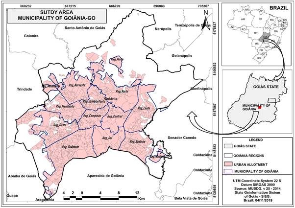
The study area is the municipality of Goiânia, capital of the state of Goiás, located in the Midwest Region of Brazil (Figure 1). The municipality of Goiânia has a total area of 728.841 km² and an estimated population in the last demographic census of 1.302,001 inhabitants, of which 1.297,076 live in the urban area and 4.925 in the rural areas (IBGE, 2010). Its urban perimeter of 256.8 km², equivalent to 59.6% of the municipality’s area, makes it considered the eighth Brazilian metropolis in the ranking of urbanized areas.
According to the Municipal Environment Agency - AMMA, the green areas, in their 12 planning regions, are distributed in 191 parks and forests, not counting the squares, ecological reserves, gardens and other areas of tree and shrub vegetation. These units are mostly made up of remnants of the dry savannah forest and the riparian forest of Permanent Protection Areas (PPAs) of water courses, which depending on their location, can be found in good condition or uncharacterized from their original landscape. Of the 191 parks and forests, only 5 have a management plan, namely: Areião Park, Bosque dos Buritis, Flamboyant Park, Botanical Garden and Vaca Brava Park.
3. Technical Procedures
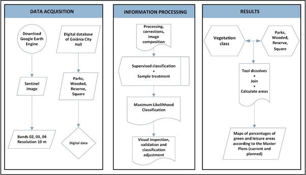
As mentioned, for the accomplishment of this work, the indirect method of spatial data processing and analysis techniques in GIS was adopted, as well as digital processing of images in clouds (cloud-computing), adapted from the proposal of Gorelick et al. (2017). Figure 2 shows the flowchart containing all the steps and procedures performed for: 1) data acquisition and survey; 2) information processing and 3) obtaining the results.
When acquiring the data, the Google Earth Engine® platform was used to view images from the Sentinel 2 Satellite with a spatial resolution of 10 meters. This refers to a ready-made mosaic of images that covers the entire municipality of Goiânia and dated on July 1th, 2019. The cartographic base of the Basic Digital Urban Map of Goiânia - MUBDG, provided by the city hall in its version 25 / was also used in 2016, with the vectors of the boundaries of the subdivisions, parks, forests, reserves and squares, in addition to alphanumeric data, with the names of the subdivisions and the dimensions of their area.
The processing and interpretation of images for the extraction of green areas were performed directly on Google Earth Engine®, a cloud-computing platform that allows the analysis of remote sensing data on a planetary scale, using automated classifiers (Gorelick, 2017). For this purpose, the techniques of atmospheric correction, enhancement and colour composition in false colour of the RGB spectral bands 4,3,2 were applied, in which the areas with the highest biomass present a red colour response, allowing to highlight areas of denser vegetation.
The supervised classification, using the Maximum Likelihood algorithm, was carried out from the training stage, which involved the collection of pixel samples representative of the spectral reflectance of the green areas. After visual inspection to adjust the classification, the resulting matrix file was converted to vectors and exported to ArcMap software, version 10.4.1, to perform the filtering of the polygons representative of the green areas.
Then, the data from the MUBDG database was merged, with the polygons classified in a single file, for the calculation of green and leisure areas within each subdivision. From this procedure, the percentage of maps of green and leisure areas were generated, representative of the subdivisions that meet or not the legislation of 10% and 7.5%.
4. Results and discussions
The parks, forests, ecological reserves, squares, gardens and other areas of tree and shrub vegetation present in the streets, avenues along riparian areas of the streams and rivers of Goiânia were essential in the definition of green and leisure spaces, represented in figure 3. In this way, it was possible to analyse that the different types of mapped green areas are distributed throughout the municipality, predominating on the margins of the water courses that configure their Permanent Preservation Areas (PPAs). Such an assessment is consistent with the notes of Streglio & Oliveira (2011), when they reveal that the urban parks and forests of Goiânia were designed in areas of springs and on the banks of water courses, which contribute not only to the preservation of vegetation, but also of water resources.
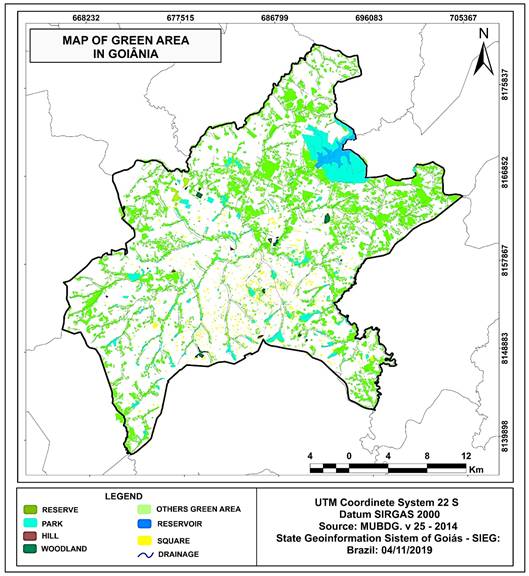
In this conception, large areas of forests and linear parks were idealized, for the healthiness of the city (Streglio & Oliveira, 2011). However, it is observed that there are stretches where PPAs should be preserved, but they are devoid of vegetation cover, reducing the amount of green areas present in the municipality. This analysis corroborates the statements of Moysés & Santos (2009) when the authors point out that the more explicit capitalist character of Goiânia's construction potential, from the 1960s on, increased its built network, which today pressures almost all the water courses that draining the capital.
From MUBDG data it was verified that Goiânia has 56.46 km², corresponding to 7.7% of its territory, consisting of Conservation Units (parks, forests, hills and reserves), which are defined by the city as protected areas and deserve special attention to biodiversity conservation. Among these green areas are the Flamboyant Park, Bosque dos Buritis, Botanical Garden, Zoological Park, Areião Park, Cascavel Park, Botafogo Linear Park and Vaca Brava Park. For Moreira & Silva (2012), they are parks and woods that symbolize not only environmental preservation, but mainly tourism development and real estate speculation, valuing the surrounding areas and attracting new investors from the civil construction market.
The areas occupied by the squares, which in this work represent free and leisure spaces, accounted for 2.16 km², which is equivalent to only 0.29% of the municipality's area. However, Arfelli (2004) points out that the equation of green areas with leisure areas in the urban land parcelling laws can deprive Brazilian cities of forested areas, insofar as these can be occupied exclusively by community equipment aimed at leisure activities. The author also clarifies that the APPs of water courses (non aedificandi strip) regulated by the Brazilian Forest Code, are not institutional areas, but were established by law in benefit of the preservation of natural water resources.
Still in relation to the analysis of the map in figure 3, it was evident that the central north and northeast portions have more expressive green areas, with connectivity in some sections. This scenario promotes the establishment of ecological corridors, which are very important for the maintenance of fauna and the local ecosystem. The centre north portion also highlights the location of the Samambaia Campus of the Federal University of Goiás, which contributes to the maintenance of large fragments of arboreal vegetation in the municipality of Goiânia. As an example, we can mention the Auguste de Saint-Hilaire Forest, which is one of the few areas that preserves primitive vegetation, of semi deciduous forest in the Cerrado Biome. This fact reveals the importance of the university green area in the ecosystem services of Goiânia.
Thus, the area of vegetation extracted from Sentinel 2 digital image processing was 146.14 km², corresponding to the “Others Green Area” typology. When added to the other typologies derived from MUBDG (Woodland, Park, Hill, Reserve, Square), a total area of 204.77 km² of green and leisure areas; that is, 28.09% of the area of the municipality of Goiânia is formed by any of the typologies mapped (Table 1).
Table 1 Types and numbers of green and leisure areas in the municipality of Goiânia
| Types of green and leisure areas | Area in km2 | (%) in relation to the total area of the municipality | Source |
| Woodland | 1.92 | 0.26% | MUBDG |
| Park | 52.97 | 7.26% | MUBDG |
| Hill | 0.25 | 0.003% | MUBDG |
| Reserve | 1.32 | 0.18% | MUBDG |
| Square | 2.16 | 0.29% | MUBDG |
| Others Green Area | 146.14 | 20.05% | Sentinel Image |
| Total | 204.77 | 28.09% | - |
Source: own elaboration
The spatialization of data, with the making of thematic maps, which meet or not the legislation that stipulates 10% and 7.5% (Figure 4), made it possible to visualize and analyze patterns, groups and trends in the distribution of green and leisure areas in accordance with legislative conduct provisions.
In Figure 4 (A) it is evident that the largest portion of subdivisions that are not in compliance with the provisions of the current Municipal Master Plan, is concentrated in the central portion of the municipality, configuring clustering of subdivisions with less than 10% of green and leisure areas. A similar situation, of central clustering is clear when using the reference of 7.5%, designed for the new draft law (Figure 4 - (B)). However, many of the subdivisions that were framed irregular considered current legislation of 10% and it will become regular when considered the new threshold of 7.5%.
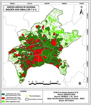
Figure 4 Result for the subdivisions that have more and less than 10% (figure 4 - A) and7.5% (figure 4 - B), of green and leisure areas in the municipality of Goiânia.
These are subdivisions that represent the areas of older neighbourhoods in the cities, such as the Central Sector, Setor Bueno, Setor Pedro Ludovico and Jardim Goiás where the urban densification is present. It was from these sectors that Goiânia began to grow and spread, configuring its current urban network. Even though it is a planned city, in the European model of “Cidade Jardim”, with its urban plot endowed with squares, gardens, parks and boulevards (Morais, 2003). Nevertheless, we must emphasize that its sprawl was marked by the devastation of the original vegetation. Currently the main representatives of the few green areas, which still remain in this highly built portion of the city and which are contemplated by specimens of the original cerrado vegetation are: Buritis Grove, the Zoo, Vaca Brava Park, Areião Park and Pedro Ludovico Teixeira Square.
The irregular distribution of vegetation, in the ways of the city of Goiânia, was also observed in some North American and Chinese cities (Wolchet al., 2014), and in the city of Curitiba (Grise et al., 2016). Hussein et al. (2018) observed, in their analyzes, in the city of Erbil, Iraq, that the newly built districts and the districts furthest from the central area registered greater vegetation coverage compared to the older and consolidated districts. This result was also observed in the studies by Stajerova et al. (2017) in the Czech Republic. These scenarios are observed due to urban development as the main gradient of fragmentation of vegetative communities (Ali and Malik, 2010).
For the analysis it was necessary to survey the number of the subdivisions constituting the neighbourhoods of Goiânia, accounting for a total of 1.089. Being that, of this total, 512 subdivisions have green and leisure areas covering less than 10%, of area, indicating that they do not comply with the norms established in the Municipal Law, nº. 7.042, of December 27, 1.991, which dealing with the Urban Plan for the implementation of subdivisions in the Municipality of Goiânia. When projected for a further scenario with the reduction of the metric to 7.5%, foreseen in the draft law of the new Master Plan, which is already under discussion in the City Council, this number reduces to 458, thus regulating the situation 54 subdivisions.
Even reducing the percentage of green and leisure areas, it is clear that a very high number of subdivisions still remained in non-compliance with the new draft law, which is equivalent to 42.05%, of the registered subdivisions by the city in the latest version of MUBDG. It is important to highlight that low percentage of vegetation can generate several socio-environmental problems, in view of the undeniable social, ecological, aesthetic, landscape, psychological and recreational functions that these areas can exercise (Astell-Burt, 2014; Jansson, 2014).
With regard to health gains, the results of research by Tong et al. (2016) reveal that vegetation attenuates the dispersion and deposition of polluting particles, produced by vehicles which affect the human respiratory system. Still in this sense, Van der Berg et al. (2016), in their research with 3.748 participants, in four different cities, confirmed the hypothesis that the most frequent use in urban green spaces is associated with a higher score on mental health and vitality scales, regardless of cultural and climatic contexts.
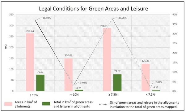
The graph in figure 5 reinforces the representation of the legal conditions of the subdivisions, related to the amount of green and leisure areas that they represent in the landscape of Goiânia. From these data, it is evident that the percentage of green areas in the subdivisions is low, and the scenario of the municipality tries to worsen with the proposed draft law of the new Master Plan for the city of Goiânia. Therefore, 3.04% of green and leisure areas, equivalent to 6.25 km², are located in subdivisions with irregular conditions at 10%. On the other hand 2.02%, which equals 4.15 km², can be considered under the conditions less than 7.5%. The fact is that from the new regulations legislative measures, these spaces may have a loss of around 2.1 km².
The reduction of the metric to 7.5%, is an element that violates the principles of good sense of the landscape and environmental quality of life in Goiânia. This fact will eliminate the obligation of several subdivisions that until then were irregular in the maintenance of green and leisure areas, to increase green areas. Added to these are the requests for new licenses, in which the 10% share destined for green and leisure areas will only be 7.5%. In this sense, Goiânia, which receives the title of “Green Capital of Brazil”, may be subject to the risk of deprivation considering of new green spaces, intended for the conservation of biodiversity and for leisure. As an example, we have the action of the Municipal Environment Agency - AMMA, which until then conditioned the licensing of large enterprises to an environmental compensation action, such as Parque Flamboyant, in Jardim Goiás; Beija Flor, in the SetorJaó and; Cascavel, in the Setor Parque Amazonas.
Source: own elaboration
Figure 5 Description of legal conditions for green areas and leisure in Goiânia.
Thus, among what was analyzed for Goiânia, we agree with the statements of Moreira & Silva (2012), when the authors point out that there is a strong relationship between urban parks and the city's aesthetics and quality of life, but also that they have a sense of environmental, social and cultural ideas. Many parks in Goiânia house areas of springs that feed the streams and rivers that cut through the city, in addition to areas of abundant vegetation that serve as habitats for wild animals and lakes with hiking trails, which present environments conducive to leisure and sports. Therefore, it is important to invest in a Forest Management Plan in the city of Goiânia, in line with the experience proposed for London. There, a plan to circumvent the scenario of irregular distribution of vegetation was proposed based on the city's Urban Forestry Strategy. It is a plan that guides measures to protect, improve and monitor the urban forest that defines London as the “City of the Forest”.
Another relevant aspect concerns the fact that green spaces need to be perceived by their users, as environments of high ecological, landscape and recreational value (Douard & Antonini, 2014). In this sense, there is a sense of security and connection with other spaces within cities. Thus, in addition to the legal obligation, the society of Goiânia may be handed over a legacy of benefits that these spaces promote to community well-being.
Regarding the compulsory donation of at least 35% of the subdivision to the municipal public administration and which has been the target of several criticisms, we share the views of Barreiros & Abiko (1998). According to the referred authors “these elements of support for the new subdivisions are, in the final analysis, financed by the community, and nothing more than fair this return occurs from a percentage of the land that should be enjoyed by the community in the form of green or institutional areas”.
5. Conclusion
The study contributed to the mapping and quantification of green spaces in the city of Goiânia and its relationship with the legislative conducts in terms of urban land parcelling. The spatial resolution of the remote sensing images proved to be compatible with the cartographic scale detailing the green and leisure areas in the subdivisions. In addition, it innovated, when discussing the legislative conduct, from the discussions of forecasts of the city's Master Plan. In this sense, from the generated analyses it is concluded that:
● Of the 1.089 subdivisions analysed, which constitute the neighbourhoods and plots defined according to the Municipal Secretary of Planning and Urbanism of Goiânia - SEPLAM, 512 subdivisions (47.02%), have coverage of green and leisure areas, less than 10%, not complying with the current regulations foreseen in the legislation;
●In a possible reduction, by changing the Master Plan to only 7.5% of the subdivision for green and leisure areas, the number of subdivisions not complying reduces to 458, which may compromise the quantitative losses of 2.1 km² of these spaces, which pass to be regulated with legislative reformulation;
● From the spatial analysis, it was observed that many of the remaining green areas are fragmented, this following the trend of other cities, since the development of urban infrastructure is the main gradient of separation of plant communities;
● From compliance with legislative conduct, it is necessary to be concerned not only with the current conditions of the municipality, but mainly with the trends that are outlined from the proposed amendment in the draft law of the new municipal Master Plan, with regard to quantitative loss of public areas destined to green and leisure spaces, required to allotments.

