


 Inglês (pdf)
 Artigo em XML
 Referências do artigo
 Enviar este artigo por email
 Citado por SciELO
  Similares em
SciELO
Similares em
SciELO 
 Permalink
Introduction
In post-independence African countries, new capital cities were built to break with “the colonial past, encourage nation-building and foster the development of their territories” (Rego, 2020, p.2; Cain, 2014; Elleh, 2017; Vale, 2008; Abubakar, 2014; Hayuma, 1980; Siebolds, Steinberg, 1980). Likewise, in South America, in 1987, Argentina planned a (never built) new federal capital, Viedma (Bauso, 2019; Bermúdez, 2016), while Brazil built a new provincial capital, Palmas, two years later (Gilbert, 1989; Trindade, 2009; Rego, 2020). Urban planning has functioned as a primary tool for reconstructing society. The transfers of governmental centres to new locations has been the catalysis for economic and infrastructural development, becoming positive stimuli for growth within their localities and nations (Mabin, Smit, 1997; Alayande, 2006). Moreover, creating a new capital city and the relocation of an existing administrative centre have been deemed a showcase for the global diffusion of planning ideas.
Historians have discussed the symbolic role of new capital cities and the effects of their construction on the countries’ progress; they have also explored the precedents of the new capital-city layouts and their aftermath on planning history (Taylor, Andrew, Lengellé, 1993; Almandoz, 2002; Hall, 1996; Gordon, 2006; Vale, 2008; Ward, 2013; Wakeman, 2016; Gordon, 2018). Compilations and comparative works on the planning of new capital cities have methodologically been circumscribed by geography, time or political regime. Though the development of African new towns has drawn the attention of recent scholarship, a comparative study of Global South new towns is still lacking. This paper aims to add to those studies by focusing on capital cities planned in developing countries in the late twentieth century.
Globalization and improvements in communications had facilitated the continued transplantation of ideologies, values and planning models, and the transnational interactions involved solving problems and improving conditions in a particular place based on experiences in other areas (Healy, Upton, 2010; Home, 2018). Developments far away therefore stimulated and conducted planning practice in developing countries, and, as elsewhere, foreign planners were called in and brought their tools with them; their local peers were also involved and pursued global models (Nars, Volait, 2013; Ward, 2000; Ward, 2013). However, these exchanges have hardly been balanced, and in such encounters, there has always been ‘negotiation’ (Said, 2007; Said, 1983). Modernity, as a globalizing force, generally emphasized similarities over differences; in times of post-colonial, post-modernist discourse and multicultural and transnational approaches, that relationship was overturned (Sandoval-Strausz, Kwak, 2017; Hein, 2017; DeVereaux, Griffin, 2006; Smith, 2005). In this paper, I examine how historically and geographically situated actors gave voice to local expressions and/or interpreted global discourses. Considering the import and export flows of contemporary planning ideas in global circulation and the notion of negotiated imposition (Ward, 2000; Nars, Volait, 2013), as well as the political conditions and governmental intentions, cultural contexts and geographical features, my focus is to investigate how local and foreign planners dealt with similar projects.
Thus, the paper reviews Abuja’s (Nigeria, 1979) and Palmas’ (Brazil, 1989) planning history. It takes into consideration the cases of Dodoma (Tanzania, 1976), Gaborone (Bostwana, 1963) and Viedma (Argentina, 1987) in order to contextualize the creation of new capital cities in developing countries in the late twentieth century. Backed by planning diffusion studies and transnational, international and cross-cultural approaches, the paper acknowledges that the spread of ideas is often diffuse and complex, sometimes including unexpected flows (Hein, 2017; Ward, 2018; Home, 2018; Ward, 2010; Bigon, Katz, 2014; DeVereaux, Griffin, 2006; Smith, 2005). It then analyses Abuja and Palmas’ layouts within a more global reading of planning history through the lens of local circumstances. It explores why those cities were still built along modernist lines, pursuing globally persuasive machine-age models and rationalist approaches. Created out of political and economic imperatives and entrusted with transformative expectations, those cities imposed a radically contrasting image to local realities, aiming at “changing society and repatterning daily life” (Home, 2018, p.91). Otherwise, why would those layouts respectively shaped by foreign and local planners amidst contemporary post-modernist criticisms and post-colonial studies depict similar responses?
New capitals in developing countries
New seats of government, amid symbolic content and functional concerns - or glory and traffic in Kostof’s terms, returned to classical formality and monumentality when it came to designing their capitol complexes (Gordon, 2018; Kostof, 1993). The Beaux-Arts and City Beautiful traditions resonated in the planning of capital cities throughout the first half of the last century as a proven model for representing identity and power using elements such as a capitol complex, monuments and public spaces. By mid-century, this model was to a great extent replaced by plans based upon the Functional City, modernist architecture and ideas derived from the Garden City movement (Gordon, 2018, p.303), with the neighbourhood unit becoming a common theme in the development of new towns. The modernist experiments of Brasília and Chandigarh spawned successors, and new capital cities have been proposed worldwide ever since.
Gaborone was planned in 1963 to house the administrative capital of independent Botswana, which until then had laid beyond the borders of the protectorate. Dodoma (1976) and Abuja (1979-1981) replaced, respectively, Tanzania’s and Nigeria’s old coastal capitals in order to stimulate the economy of neglected central regions. The Argentinian President’s plan for transferring the federal capital from Buenos Aires to Viedma was designed to help transform the country, reduce hyper centralization and stimulate development in the Argentine periphery - a growth pole in Patagonia (Gilbert, 1989; Bermúdez, 2016; Bauso, 2019). The creation of Palmas (1989), a new provincial capital city in post-dictatorship Brazil, conveyed similar intentions (Rego, 2020; Trindade, 2009; Velasques, 2010; Segawa, 1991). The planning of Abuja (Ebo, 2006) drew heavily on overseas models and experiences, though the adoption of modernist principles had been criticized as an ongoing practice of colonial domination; the cases of Gaborone, Dodoma, Abuja, and Palmas were not different. Apart from Palmas and Viedma, these new towns were not planned by local professionals, confirming diverse external links (Ward, 2010). Gaborone’s Master Plan was prepared by the Public Works Department in Mafikeng, in South Africa. A North-American team initially outlined Abuja, which was then developed by a Japanese architect. Canadian planning consultants prepared Dodoma’s plan. Palmas, however, was designed by Brazilian architects who graduated from post-graduate courses in British universities. Nevertheless, these cities were all planned along modernist lines, with their schemes revolving around the Functional City paradigm and the Garden-City model.
The concept of Functional City, the most significant theoretical approach of CIAM - the Congrès Internationaux d’Architecture Moderne - began to dominate its discourse in the early 1930s (Mumford, 2000, p.59). Le Corbusier claimed a “doctrine of urbanism” and advocated that CIAM should link “architecture and town planning with social evolution” (Mumford, 2009, pp.4 and 7). According to Rego (2020, p.2), CIAM defended the four urban functions of dwelling, work, transportation and recreation, and advocated combining the abstract, defamiliarizing modern art strategies with an aggressive celebration of new construction technologies. Modernist planning was based on a rational and comprehensive model that emphasized grand plans, and programs developed by experts were implemented using a top-down approach to planning in order to break with tradition and initiate social change through the defamiliarization of the urban form (Holston, 1989). It favoured scientific knowledge and objectivity over local values, context and input (Abubakar, Doan, 2010). The modernist city meant a totalizing rationality; redefinition of the social functions of urban organization; development of building typologies and planning conventions as instruments of social change; and decontextualization and environmental determinism. As in the story of Brasília, the modernist city had a transformative role, which was to create not only a new physical environment but also a new social order (Holston, 1989; Gilbert, 1989).
In post-independence African countries, planners dealt with a general adverse context “where poverty is pervasive, urban boundaries are fluid, the rights of urban citizenship are not universally claimed or bestowed, and there is no clear conception of what constitutes an Africa city or an African urbanite” (Parnell, 2018, pp.288-289; Abubakar, Doan, 2010). For instance, Gaborone was built close to the existing Gaborone Village, but no attempt was made to incorporate the village into the new capital; they remained as separate entities (Best, 1970, p.4). It was planned as a Garden City with low density and one-story buildings, and large plots still characterize the cityscape. In hindsight, the UN-Habitat report states that “the regulatory aspects of modernist planning (land-use zoning and building regulations) have usually required people to comply with particular forms of land tenure, building regulations, building forms and construction materials, usually embodying European building technologies and imported materials, and requirements for setbacks, minimum-plot sizes, coverage, on-site parking, etc.” (UN-Habitat, 2009). The modernist approach to urbanism was little, or simply not, interested in accommodating the inhabitants’ traditional ways of life. The characteristic African inclination to community living contrasted with numerous state-planned and mechanically executed housing developments (Kultermann, 1969, p. 23). In the late 1960s, the necessity for combining “newly activated African tradition, which is still largely unconscious, and the latest technical and construction methods from abroad” had already been noticed (Kultermann, 1969, p. 12).
However, by the time the plans for Gaborone, Dodoma, Abuja, Viedma and Palmas were created, the modernist city idea and its standardized, universal solutions and overreliance on the private motorcar were under criticism while rising ecological concepts were modifying planning practice. The modernist tendency to treat every design as an abstract problem, indifferent to its context, was at stake, and cultural variables were being included in the design process to prevent inconsistency between form and context (Forty, 2004, pp.132-135). It was claimed that modernist planning undermined social life’s vitality because it discouraged diversity within cities and reduced urban interactions at street level (Jacobs, 1961). Even so, the image of the ‘flawless’ modernist city conveyed the radical urban and social transformation many countries pursued.
Scholars have noticed how indelible modernist ideas moulded the ambience of new towns in developing countries and how little native values, urban fabrics and building types have mattered, despite contemporary arguments that the behavioural and socio-cultural aspects of built forms imbue environments with meanings and help to create a sense of place (Elleh, 2017; Abubakar, 2014; Abubakar, Doan, 2010; Ozo, 2009; Vale, 2008; Chokor, 2005; Mosha, 1996; Rego, 2020; Rego, 2017). Modernist urbanism overcame these defiant ideas. In general, the transformative role of universally valid rationalist proposals prevailed over observing local cultural contexts and traditional urban forms, but let us follow more closely what happened in the planning of Abuja and Palmas.
Abuja
Abuja stemmed from a post-colonial national modernization endeavour. Nigeria experienced a period of high optimism that prompted reconstruction projects due to the end of the civil war (1967-1970) - just a decade after independence from Britain - and the country’s oil production boom. The development of the new national capital was one of the major items on the military regime’s agenda, which took power in 1975. The development of Abuja, initially a national project, became a global one involving parties from other countries and continents, with different planning models and traditions (Elleh, 2017; Vale, 2008).
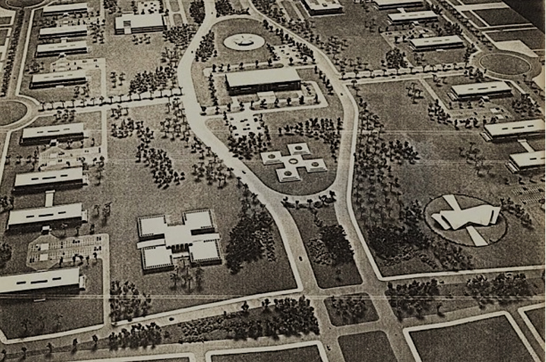
Abuja’s master plan was approved in 1979, with initial work having started a couple of years before with the selection and commission of the American consortium, International Planning Associates (IPA), recognized for their 1976 comprehensive landscape plan for Washington D.C. IPA was led by American architect and urban designer Thomas Todd of WMRT, a Philadelphia-based office founded by David A. Wallace, planner, architect and regional planner; Ian McHarg, landscape architect and environmental planner ; William H. Roberts, landscape architect; and Todd himself (Figure 1). The master plan developed by IPA was then detailed by the Japanese firm Kenzo Tange Urtec, and Tange’s design was presented in 1981. The selection of Tange’s high-profile name was related to his global prestige “because of the advantages, especially in international financial circles, of using world-famous urban designers”, according to a memo from the design contest (Elleh, 2017, p.83). By this time, another regional master plan was developed by a firm founded by Constantine Doxiadis. In 2004, German firm Albert Speer and Partner were commissioned to review Abuja’s plan (Elleh, 2017; Vale, 2008, p.157). Researchers have shown that Abuja’s planning models comprised real or imagined parts of Brasília, Chandigarh, Canberra, Washington D.C., New Delhi, Milton Keynes, Paris and Tokyo.
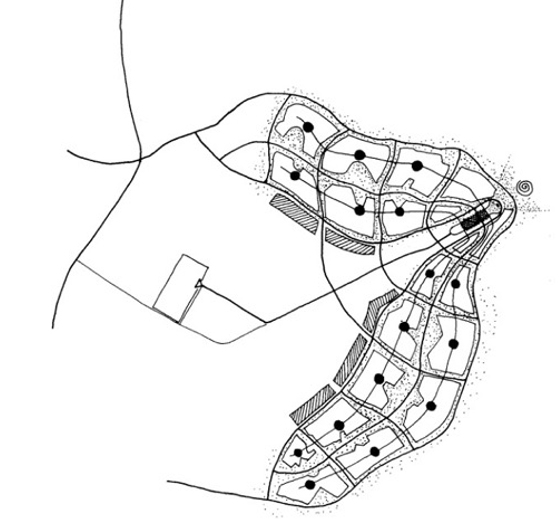
Master Plan for Abuja, IPA.
Source: Figure 1: Basic urban form of Abuja showing sectors and central core, 1979
WMRT’s design managed to use the natural landscape to enhance monumentality, recalling Walter Burley Griffin and Marion Mahony Griffin’s outline for Canberra, one of the cities visited during the preliminary research phase of Abuja’s planning (Elleh, 2017, p.12). The initial master plan, sensitive to the natural landscape, depicted Garden City features and Beaux-Arts composition solutions. Although WRMT was replaced by Kenzo Tange’s team, the original master plan structures were carried through, along with McHarg’s ecological planning principles. However, while Todd admired the urban forms of Washington D.C. and Canberra, Tange preferred those of Chandigarh and Brasília. Thus, considerable changes were made in the city’s central area as Tange’s design brought in modernist aspects (Tobin, 2017; Ikoku, 2004).
Abuja city is located in the central part of Nigeria, roughly 700 km northeast of Lagos, the former capital of the country located on the Atlantic Ocean shore. The new federal-capital territory was chosen after considering its ethnic neutrality and central location in the heartland, which was potentially accessible both physically and socially to all parts of the country (Ikoku, 2004) . IPA had mapped out the federal-capital territory, including bedrock geology, elevation, slope, and drainage density, and referred to Kevin Lynch's «imageability» concept to describe the type of city they wanted to create (Ikoku, 2004; Elleh, 2017). The city’s location, its layout and the interplay with the surrounding landscape stems from McHarg’s environmental thinking. Escarpments on the North, East and South framed the crescent shape of the city. The monumental Aso Rock, a huge granite outcrop that rises 400 meters above the plains, stands in the background northeast of the modernist civic centre, where the National Assembly Complex, the Presidential Palace and the Supreme Court of the Nation are located. The regular layout of the Mall in front of Aso Rock turns into an adaptable, loose grid that defines the garden city-like, low-density winding urban areas.
The overall plan projected a target population of approximately 150,000 in 1986 and doubled this by 2020. The area dedicated to open spaces was roughly equivalent to two-thirds of the area dedicated to residential use. Residential areas were organized in a hierarchical structure with large units called sectors, planned as ‘small towns’ to accommodate between 200,000 and 250,000 inhabitants. Each sector was subdivided into 3-4 districts, housing between 40,000 and 60,000 people each. Districts were then subdivided into communities defined by curvilinear streets. Like the sectors, districts and communities were to have their own centres, intended to be self-sufficient. The sector centre was located along the transitway system to facilitate accessibility, and it was meant to be self-contained concerning to commerce, public services, post-secondary and special education facilities, hospitals, and a library. According to a Nigerian architectural historian (Elleh, 2017, pp.175-176), the neighbourhood-unit concept underlies the community organization and the scale suitable for provision of many household-related services; its centre should contain a church, mosque, primary schools, market and shops, health clinic, post office and police station (Abubakar, 2014, p.84. Figure 2).
https://en.tangeweb.com/works/works_no-66/.
Source: Figure 3: Kenzo Tange’s plan for Abuja mall and the civic centre, 1981
Tange redesigned the central zone, renamed as the ‘three arms zone’, thus openly invoking Brasília’s architecture (Figure 3). The National Assembly Complex kept its original setting as defined by IPA, with the Presidential Complex added to the left and the Supreme Court to the right of the main building. Unlike Brasília’s Three Powers’ Plaza, these buildings are distant from each other and, unlike other paradigmatic civic centres, Abuja’s became disconnected from the Mall and the city itself. Wide roads and multilane boulevards isolate blocks, rather than connect them - like in Palmas, as we shall see - and parking spaces insulating the buildings along the Mall endorse the notion of a city planned for the automobile (Vale, 2008, p.172).
This kind of urban form, according to Abubakar, is undeniably a Western concept alien to African culture, which encourages neighbourliness and high levels of interaction (Abubakar, 2014, p.84). The discrepancy between traditional Nigerian urban form and the imposing design of the modernist Mall was also noticed by Vale (2008, pp.170-171). Kenzo Tange indeed held that “Abuja is anti-Lagos”, referring to the abundance of land in the new territory in contrast to the overcrowding in the former capital city (Elleh, 2017, p.205). It has been acknowledged that local artistic patterns interested not only Tange but also Todd and his team, and somehow were part of Tange’s design, which is just a symbolic detail in the face of the innovative urban living conditions (Elleh, 2017, pp.206 and 210).
According to the master plan, Abuja’s development was based on equal access, equal citizenship, environmental conservation, the Garden City, Functional City, effective regional development, and rapid national economic growth (Abubakar, 2014; Ikoku, 2004, p.37). However, scholars have recognized that modernist architecture and planning, idealizing urban form and life, endorsed domination and control patterns, returning to a certain extent to colonialism, and exacerbating spatial exclusion and social inequality (Ebo, 2006; Holston, 1987; Vale, 2008).
Palmas
The capital of the Brazilian state of Tocantins was created out of political and economic imperatives and instilled with expectations of transformation. With the end of the military regime (1964-1985), the 1988 national constitution had established the new state of Tocantins, an impoverished rural territory with unexploited mineral and hydroelectric potential, which was only partially fulfilling its agricultural potential, relying mainly on cattle raising and enduring socio-economic chaos. Brazil was then enduring what was termed the (economically) lost decade - the 1980s. Like Abuja, the creation of Palmas in the central area of the state - eight hundred kilometres north of Brasília - was intended not only to project an urban image of progress but also to boost the development of the region. It originally envisaged one-and-a-half-million citizens. In the post-dictatorship period of economic recession, and amid local setbacks and the intensification of social movements, the creation of a new state and its capital city was once again perceived as a potential opportunity to give rise to progress and regional development (Trindade, 2009, p.65; GrupoQuatro, 1991, p.95).
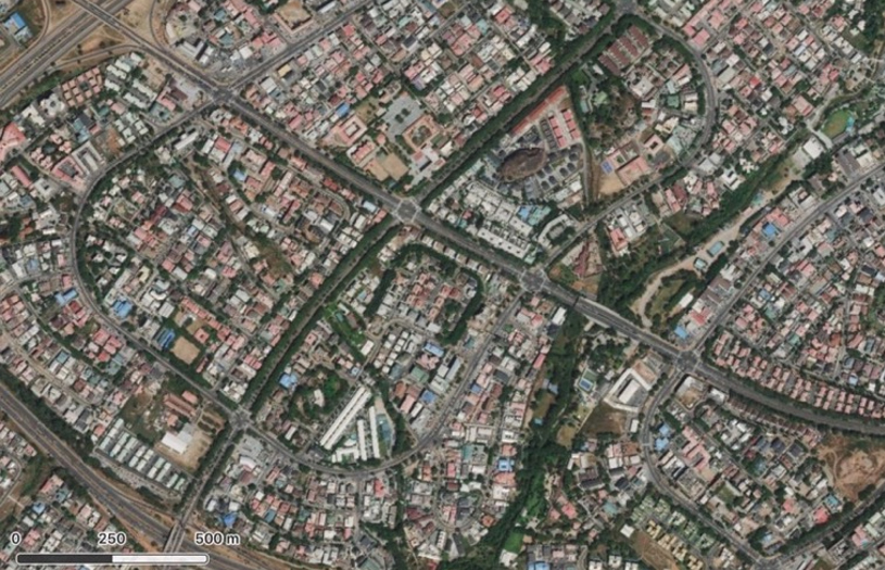
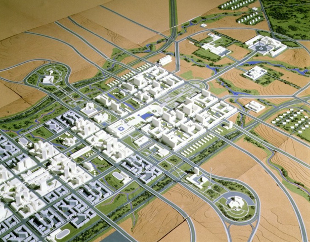
Unlike Abuja, which was conceived by a series of foreign planners, Palmas was outlined by local professionals. Luiz Fernando Cruvinel Teixeira and Walfredo Antunes de Oliveira Filho, Brazilian architects graduated from the University of Brasília, were purposely hired by the Tocantins governor. Teixeira had attended two post-graduate courses at the Architectural Association in London (Tropical Studies in 1969 and Town Planning and Design in 1974), and Oliveira Filho specialized in landscape architecture and got a master’s degree in Regional Planning from the London School of Economics in 1980 (Velasques, 2010, pp. 70-75; Rego, 2020, p. 6). Probably due to their overseas academic experience, the planning team visited Milton Keynes, one of the most “celebrated places in the broad landscape of twentieth-century urban planning” (Wakeman, 2016, p. 212), which became a planning model for Palmas, along with the controversial Brasília (Figure 4).
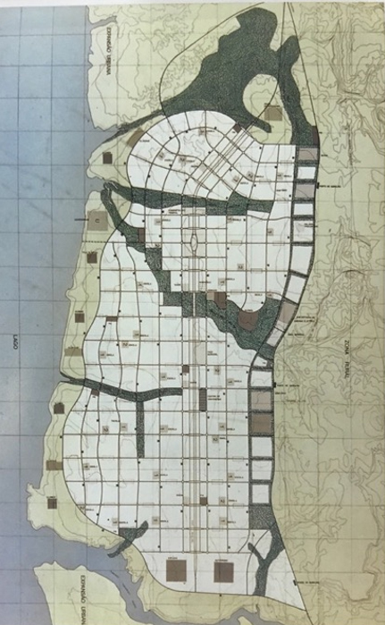
The gigantic grid, wide avenues, functional zoning and the adaptation of the neighbourhood-unit concept are the salient features of Palmas (Rego, 2020). The practicality of Portuguese-colonial gridded towns was developed to an unusual scale in Palmas’ flatlands. Tocantins’ capital-city layout depicts a relatively loose, site-adjusted network, with the patchwork created by the unique design for each macroblock’s inner occupation contrasting with its outer regularity. The north-south linear layout is adapted to a long, fifteen-kilometre wide terrain, limited by the Tocantins River on the west and Lajeado hill on the east. The singular landscape, natural resources, and easy accessibility influenced the selection of the setting, which influenced the planning approach and was utterly integrated into the planning proposal according to the planners (GrupoQuatro, 1991, p. 95), thus echoing contemporary ecological notions.
Palmas’ outline both rejected and, at the same time, endorsed Brasília’s urbanism (Rego, 2020). The modernist construction of Brasília, still in the democratic period before the dictatorship, was later linked to the dictatorial regime (as noted by a Brazilian architectural historian. Segawa, 1997) as, when major criticism of modernist architecture and urban approach later abounded, it did not find a welcoming environment in Brazil. Paulista brutalism was then the hegemonic architectural expression, and the military government promoted it as a potent image of the developing country. The vigorous and widespread production of modernist architecture and the repressive, nationalist regime had led to an insular position, causing the late absorption of post-modernist thinking (Gold et al, 2019). But this did eventually happen and, thus, in contrast to Brasília, Palmas’ outline rejected the modernist standardized housing and the uniformity of the federal capital superblock in favour of a more heterogeneous townscape: a relative reaction to rationalist planning, aiming at a less authoritarian structure than Brasília’s superblocks. However, while eluding Brasília’s monumentality, uniformity and standardization, Palmas’ civic centre does recall the modernist city’s organization, with the arrangement of the main public buildings and governmental palace upon a vast green open space (Rowe, Kroetter, 1995. Figure 5). Vegetation and distances prevent perspectives of the ensemble, which evokes Corbusieran green extensions and isolated blocks. Despite being “site-purposed and designed upon ecological considerations,” with the “gridiron fitting natural conditions” and the “resulting urban form strongly related to the landscape”, Palmas is modernist in its super-wide avenues: still a city for the private motor car (Rego, 2020, p. 12; Teixeira, 2009).
Palmas portrays a relative centrality, in an otherwise non-hierarchical linear form, with the central longitudinal axis that organizes the city form and leads to the civic centre. The city plan follows the segregation of urban functions as encouraged by the Charter of Athens. A central commercial area was originally located around the central park and the insulated civic centre: a pedestrian zone containing stores, offices, businesses, company headquarters and banks. Industrial and regional-scale commerce and services were located on the edge of the city. Urban-scale commerce and service areas were placed along the central axis, with the residential macroblocks beyond them. The original land-use allocation was approximately 37% for residential spaces, 26% for green open spaces, 18% for institutional, governmental and cultural purposes, 11% for roads and 8% for commerce and services (Xavier, 2007, p. 68).
The residential areas were planned as a collection of neighbourhoods, created by gigantic, geometric macroblocks, which adapted Clarence Perry’s concept for housing a population of between 8,000 and 12,000 inhabitants (Figure 6). The neighbourhood unit was once more adapted and tamed into a local modernization process, as in Abuja (Lu, 2006). Palmas’ neighbourhood units are another legacy of the modernist urbanism and the Americanization of Brazilian cities, insisting on a planning scheme that had long been contested in favour of more urban diversity (Rego, 2019; Rego, 2017; Jacobs, 1961). Unlike Brasília, though, each of Palmas’ macroblocks individuality was to be enhanced through a unique internal urban layout and design. The macroblocks’ diverse inner form avoided the modernist uniformity, though it lacked legibility and has created a puzzling urban image. Some macroblocks present a grid pattern, while others present an informal layout of winding roads.
Defined by a grid of 700x700 meters, macroblocks were to contain an outer green belt and have only two entrances, thus enhancing their insular environment, as local commerce for daily life was contained within it, with no need to leave the residential blocks and cross the highways for daily shopping necessities. Irregular secondary roads lead to the residences. Schools and public facilities were to be settled on their central cores in free configurations, with just one set of items being predefined: a certain density (up to 300 inhabitants/hectare), the existence of vicinal commerce along their edges and basic social and religious facilities (O Ideal e o Real, 1991, p. 106; Teixeira, 2009, p. 95; Rego, 2020, p. 8). Low density, a green ambience and wide roads endorsed Palmas’ late-modernist appearance. Distinct residential types were foreseen and, in contrast to Brasília, the planning intention was to adopt an individual scale, with the single-family residence being the starting point of block organization as a rhetorical response to the conventional citizen whose urban reference was the detached house, private plots and street corners - a clear reference to a more traditional urban setting. Thus, internal roads were to promote social integration and the core of the neighbourhood was to stimulate community life by being a meeting point (Trindade, 2009, pp. 73-74).
Palmas’ layout has fulfilled its symbolic role. Besides this, the Tocantins state’s new capital city has been responsible for creating economic growth and spreading regional development: urbanization and prosperity correlate. However, social inequalities have been endorsed by spatial segregation (see Kran, Ferreira, 2006). To a certain extent, it abandoned the radical modernist utopia, though expected citizens to comply with a rather alien urban form and an idealized city life, which has not happened.
Discussion and concluding remarks
This paper has considered two new capital cities planned in distinct continents and presented the similarities and affinities that exist between them despite their specific contexts. Palmas was promptly planned by local planners in the first years of Brazil’s re-democratization process, while African Abuja was conceived and mainly built during a dictatorship. Both enterprises aimed to develop the hinterlands and create a modern representative image. Abuja was a response to the aspirations of dissociating Nigeria from its colonial heritage and catching up with the west. Although Palmas planners’ intention was rhetorically not to emulate Brasília’s urbanism, the new provincial capital city stemmed from it. Similar global planning models influenced both layouts, be they imported or locally fabricated. Native and foreign methods did not differ, and so the repertoire of differently (geographically and historically) situated planners converged.
The main transnational flow of planning ideas at the time still promoted alluring images of the modernist town, in tune with the progressive aspirations those governments pursued. Would traditional dwellings and urban forms have equally appealed? Hardly, I am afraid. Physical changes were implemented in order to represent political changes, foster economic changes, which has been achieved to a huge extent - and signalize social changes. The way the people lived was subjected to a radical transformation and they have not entirely complied with it - a topic to be further explored.
Palmas and Abuja were planned along with environmental concerns, but other post-machine-era thoughts little or simply did not contribute to the projects. In both cases, urban individuality and imageability were strongly based on local natural features. Both urban forms depicted the motorcar-dominated urban model. As Vale noticed in the case of Abuja (Vale, 2008, p.171), which also applies to Palmas, it was the design of a modern urban capital to be the symbol of largely rural territory. As such, the late-modernist plans of those capital cities emphasized rationalist urbanism, and the physical aspects of planning paid little (or no) heed to local knowledge and cultural practices. The planners strived to create a good urban environment, and the highly idealized, innovative urban forms ended up being alien to the actual citizen and their conventional city life. Although related to particular physical circumstances, these layouts were, as they were intended to appear, fairly global.
The (still locally unfamiliar) neighbourhood unit - amidst the Garden City idea and functional zoning - pervaded both layouts. It was rather re-imagined than simply adapted, thus creating peculiar urban forms. In the re-imagination process, though, cultural practices, local traditions and the shaping of physical urban elements through mirroring social conventions and shared convictions were lesser factors vis a vis the globally persuasive planning idea. Planners dealt with more abstract reasoning in response to more universal stimuli. A transformative role was assigned to the new urban form as a new, ‘different’ way of living was fabricated. These plans for new capital cities in the Global South ended up endorsing the asymmetric dynamics in which the transnational practices were usually embedded.
In the transnational flow of planning ideas into developing societies analysed in this paper, modernizing efforts were less interested in interpreting particular cultural identities onto the imagined urban forms of capital cities than in echoing globally valid rational solutions. Observing the contemporary planning ideas, related socio-political conditions, planners and plans, the paper has shown that the large frameworks in which ideas travelled, the effects of globalization and the hegemony of the modernist city image overlapped with the expression of local differences, although the layouts circumvented the visual homogeneity usually expected to ensue from globalization.

