


Services on Demand
Journal
Article
 English (pdf)
 Article in xml format
 Article references
 Send this article by e-mail
Indicators
-
 Cited by SciELO
 -
 Access statistics
Related links
-
 Similars in
SciELO
Similars in
SciELO
Share

 Permalink
Tourism & Management Studies
Print version ISSN 2182-8458On-line version ISSN 2182-8466
TMStudies vol.14 no.3 Faro Sept. 2018
https://doi.org/10.18089/tms.2018.14302
TOURISM: SCIENTIFIC PAPERS
Determination of tourist flow patterns in a low mountain study area
Determinação dos padrões de fluxo turístico numa área de estudo de baixa montanha
Borbála Benkhard1
1University of Debrecen, Department of Landscape Protection and Environmental Geography, Hungary, benkhard.borbala@science.unideb.hu
ABSTRACT
Understanding the movement of visitors contributes to appropriate management plans for visitor destinations. Determination of this movement is composed of not only the identification of the starting and end points together with the sequence of stops but the characterisation of the route pattern as well. The type of this pattern depends on the human apart from outer physical parameters and the available time thus it has a relationship with the behaviour and type of the tourist. Understanding and making use of these are important measures for organisations managing natural areas. Observation of visitors in natural areas is not possible in every environment while reducing the tread of certain popular sites can be made only with the help of such knowledge. This explains that literature describing different patterns analyse inter- destination relationships. In this paper the identification of the movement pattern of hikers in a mountainous study area is presented. Visitor flow analysis of a study area in Hungary (180 km2 area of Central Börzsöny in Duna-Ipoly National Park) was performed on the basis of a questionnaire survey carried out with the help of volunteers. Based on the analysis of the obtained data the accurate description of the movement of both individual hikers and groups became possible. Mathematics based definition of hiking routes completed in mountainous areas is new to the available data in the literature. Patterns of one day routes were classified into 6 types and two types of hiking routes requiring several days were also identified. Different route types were observed at the different entrances of the destination. Such information helps the identification of visitor types at the starting points and the design of appropriate visitor management measures.
Keywords: Visitor flow, tourist movement pattern, behaviour, spatial movement, itinerary model.
RESUMO
Compreender o movimento dos visitantes contribui para desenvolver planos de gestão apropriados para os destinos. A determinação desse movimento é composta não apenas pela identificação dos pontos iniciais e finais, juntamente com a sequência de paragens, mas também pela caracterização do padrão de rota. O tipo desse padrão depende, do fator humano, além dos parâmetros físicos externos e do tempo disponível, tendo consequentemente uma relação com o comportamento e o tipo do turista. Compreender e fazer uso desses padrões são medidas importantes para as organizações que gerenciam áreas naturais. A observação de visitantes em áreas naturais não é possível em todos os ambientes, ao passo que a gestão de certos percursos pode ser feita apenas com a ajuda de tal conhecimento. Isso explica que a literatura que descreve diferentes padrões, analisa relacionamentos entre destinos. Neste trabalho é apresentada a identificação do padrão de movimento dos caminhantes numa área de estudo montanhosa. A análise do fluxo de visitantes de uma área de estudo na Hungria (área de 180 km2 do Börzsöny Central no Parque Nacional Duna-Ipoly) foi realizada com base num questionário realizado com a ajuda de voluntários. Baseada na análise dos dados obtidos, a descrição precisa do movimento de grupos de caminhantes e caminhantes individuais tornou-se possível. A definição baseada na matemática de rotas de caminhadas completadas em áreas montanhosas é nova para os dados disponíveis na literatura. Padrões de rotas de um dia foram classificados em 6 tipos e dois tipos de rotas de caminhada exigindo vários dias também foram identificados. Diferentes tipos de rotas foram observados nas diferentes entradas do destino. Tais informações ajudam na identificação de tipos de visitantes nos pontos de partida e no planeamento de medidas apropriadas de gestão de visitantes.
Palavras-chave: Fluxo de visitantes, padrão de movimento turístico, comportamento, movimento espacial, modelo de itinerário.
1. Introduction
Publications analysing the movement of tourists become increasingly widespread as the economic strength of the branch increases. Studying covered distances, selected routes (and traffic network) and the spent time gives essential data for creating services and planning developments. According to Lau and McKercher (2007) analysing the pattern of travel between destinations (either between continents or within larger countries) is more frequent (Flognfeldt, 2005; Lue, Crompton & Fesenmaier, 1993; Nickerson, Bosak & Zaret, 2009; Oppermann, 1997) than that of flown and distribution within a single destination (e.g. Debbage, 1991; Gao, Hsueh, Liu, Lee & Huang, 2013; Lew & McKercher, 2002; Zoltan & McKercher, 2015).
The aim of intra-destinational studies is also providing basis for infrastructural developments and for the optimal design of services and the application of appropriate visitor management measures. Furthermore, especially in the case of natural areas this is the basis of preserving values since determination of the carrying capacity of more sensitive areas, selection of necessary measures and the appropriate visitor management measures cannot be made without the knowing the number, movement and type of visitors (Eagles & McCool, 2004; Manning, 2002; Newsome, Moore & Dowling, 2007).
There are several reasons for the formation of different visitor flow patterns in certain tourist destination areas (McKercher & Lew 2004; Lau & McKercher, 2007; Lew & McKercher, 2006) the most difficult of which maybe the measurement of human factors. Knowing these, however, especially if the physical conditions of the destinations are similar, is essential since human factors influence primarily the characteristics of different flow patterns. Therefore, the study, determination and analysis of such patterns help the process of defining tourist types. Consistent use of patterns described in previous research (Flognfeldt, 1999; Lew & McKercher, 2006; Lue, Crompton & Fesenmaier, 1993; Mings & McHugh, 1992;
Oppermann, 1995) is not always possible in every destination area in the lack of accurate definitions. Moreover, visually similar but not completely similar patterns regarding the aims of the research have to be separated.
The primary aim of the present paper is to identify and define flow types and patterns formed in natural environments. In order to achieve this, the movements of hikers in a mountainous area are studied. The study area is part of the Börzsöny in the Duna-Ipoly National Park. Patterns of the measured flow routes are classified into categories with the help of mathematic calculations. According to the literature, certain pattern types are in relationship with different tourist types. Knowing such patterns therefore makes it possible to identify the visitor types in certain parts of the study area contributing to the selection of appropriate visitor management measures and communication techniques.
2. Literature review
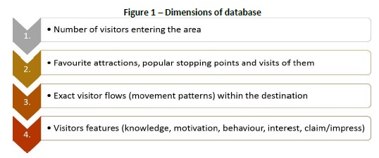
Data of visitors of an area can be obtained at various levels. Individual levels enable different (increasing) detail of analysis (see Fig. 1).
Visitor monitoring, counting visitors and observing their movements give the basis of park management in most national parks (Eagles & McCool, 2004). Most methods applied to analyse international tourist movements, however, cannot be applied in nature protection areas. Most data acquisition methods, like counting machines determine the number of visitors at the area, while geotagged images help to identify preferred destinations or stops as well (Kádár, 2014; Michalkó et al., 2016; Orsi & Geneletti, 2013). Besides their numerous advantages fix equipment is rather expansive (Cessford & Muhar, 2003). Moreover, appropriate sites for counting and ideal places of installation are hard to identify (Andersen, Gundersen, Wold & Stange, 2012; Rupf, Wernli & Haller, 2008) in accessible areas with good tourist road network (e.g. mountainous areas in Hungary).
Detailed tread of the whole area can be pictured with recording the exact movements of individual hikers but methods related to such measurements cannot be applied anywhere and at anytime. Self-assessment of the visitors (e.g. route registration in American national parks, quest books of tourist houses in Scandinavian countries (Kajala et al. 2007)) yields contingent results (no matter whether routes are asked on paper or in digital form). Survey with interviewers gives more accurate results (Muhar, Arnberger & Brandenburg, 2005) but this, similar to counting performed by volunteers, requires significant labour force. Giving the visitors GPS devices (Arrowsmith & Chetri, 2003; Beeco et al., 2013; Oranella, Bregt, Ligtenberg & Wachowicz, 2012; Zakrisson & Zillinger, 2012) or TrackSticks (Rettie, 2012) can be applied rarely and the application of the method depends on the size of the studied area and the cultural background of the visitors. Collected data can be evaluated when the device is returned at the end of the well-defined counting period. Telephone applications helping orientation in a given area not only helps visitors but may yield information on the movements of the visitors to the manager of the area (Liu, Chu, Lin & Chang, 2013). Cell information from mobile suppliers could also be used to track visitors (Shoval & Isaacson, 2007), however, they show only those sites where mobile network is available continuously therefore the method is limited in the narrow and deep valleys of mountains. GPS signs are also influenced by relief (and actual satellite movement). Therefore, the application of so called location- sensing technologies is limited and can be used to track the movement of visitors in space and time primarily in lowland areas (Meijles, Bakker, Groote & Barske, 2014; Oranella, Bregt, Ligtenberg & Wachowicz 2012).
Tracking tourists and observing their flow pattern are currently not solved in natural areas and in national parks in Hungary. Determination of visitor numbers is estimated on the basis of registered data of services or attractions that enable counting like sold entry tickets at exhibition sites or numbers of visitors applying for guided tours. Most protected areas, however, can be visited without purchasing a ticket and without visiting any built infrastructure (e.g. visitor centre). As a result, the real number of visitors could be significantly different from those who were registered.
Models showing the movement of tourists can be divided into three groups (Hall, 2012): mathematic models (e.g. Arrowsmith & Chetri, 2003), models based on the visual representations of spatial data (e.g. Flognfeldt, 2005) and descriptive models based on empirical analyses, case studies (Oppermann, 1995).
Describing spatial models, Lew and McKercher (2006) identified two major characteristic tourist movements: linear and spatial. In their work the point of relevance was the accommodation in both cases (assuming that the tourist spends several days in the given destination). Accordingly, spatial models study the distance covered in relation to the accommodation while linear models analyse the pattern of the route taken. Although the present work discusses the flow pattern of the hikers in a destination in a particular natural area, overviewing the different studies of other scientists is useful. For example, the pattern of travels into a given destination was studied by Mings and McHugh (1992) while Lue, Crompton and Fesenmaier (1993) described travels stopping in several destinations. Flognfeldt (1999, 2005) analysed different patterns between the place of residence and the destination. McKercher and Lau (2008) identified patterns in urban destinations using a GIS software.
Classifying linear models determined by previous research (Flognfeldt 1999; Lue, Crompton & Fesenmaier, 1993; Mings & McHugh, 1992; Oppermann, 1995) Lew and McKercher (2006) identified three different types lasting from points to points (“Type P1 Pont-to-Point Patterns”), two circular ones (“Type P2 Circular Patterns”) and one complex pattern (“Type P3 Complex Patterns”) that can be random or radial circular movements (“Random Exploratory (P3a) or Radiating Hub (P3b)”). This is one of the most frequently referred classification (Lew & McKercher, 2006) that gave the basis for my research as well.
Apart from choosing the applied models the description of the patterns also depends on the aims of the research (e.g. development of the infrastructure of the destinations or stops, or modification of the connections between mass transport to a particular destination). As a result, the same pattern can be described differently in different publications, like “round shape trip”.
▪ when “tourists travel to a region they visit a series of destinations in a sequence before returning to their origin”: regional tour (Lue, Crompton and Fesenmaier (1993, p. 295) analysed multi-destination pleasure trips);
▪ or: “movement starts at the accommodation and include visits to two or more attraction stops in a circular pattern”: circular loop (Lew and McKercher (2006, p. 418) aimed to explore some of the conceptual challenges in understanding tourist intra-destination movement patterns).
In our case since a later aim of the research include the more accurate determination of movements in the study area and the employment of the individual routes relative to each other, categories identified so far are not accurate enough for our research. All of the patterns identified by Lew and McKercher (2006), and Lau and McKercher (2007) could be observed in the course of my survey as well. It is important to emphasize, however, that only the patterns with similar intersection and edge conditions show overlap with Hungarian patterns, most of the movements described by them could not be observed in the study area!
According to Lau and McKercher (2007) the factors influencing the movement of tourists can be classified into 3 groups: human, physical and time factors. Studying the human factors important regarding visitor management results in typifying tourists. Identification of tourist typologies was first based on psychology (Plog, 1974) and sociology (Cohen, 1972) and the ratio of familiarity-novelty determined it. Personal types identified by Plog travel to different destinations as tourists or their activities are different at the same destination (Plog, 2002). Cohen typified tourists based on their institutionalization while Smith (1989) classified visitors based on their relation to local norms and local culture (Puczkó & Rátz, 2000).
We have to admit, however, that within the same unpopulated destination different visitor types can be observed but they can all be only wanderers or discoverers, i.e. involved in not- institutional tourism (Cohen, 1972) who employ no services (only signs helping orientation at the most). Identification of these types is also important for the management (Beeco, Hallo, English & Giumetti, 2013). Recognising this, other scientists identified new categories analysing movements within destination and also created different categorisations based on different aspects (Arrowsmith & Chetri 2003; Beeco et al., 2012; Zakrisson & Zillinger, 2012). Not only the visited sights, spent time but the pattern of the selected routes can also be associated with certain tourist types and the relationship can be verified numerically (Gao & Hsueh, 2014).
None of the typifying systems are applied in the present research but based on the results of the researches presented above, the author considers openness to the values of the study area, the national park in our case part of the human factors responsible for the development of certain patterns. This characteristic is in close correlation with motivation, and preliminary knowledge as well. It is important to note, however, that the route of a group of visitors is determined by that who decides the movement of the group (guide for example) or by the factor influencing the route most (e.g. participant with worst fitness). As a result, the tourist type associated with the pattern applies to all members of the group because their movement reflects this type of attitude, behaviour, human factor.
Important differences were found in two cases between the relationships determined by the above professionals and the research of the author when the background of the patterns exposed by field research and case studies was studied.
1. Lew and McKercher (2006) explained the random exploratory movement pattern (in their view this “shows no or only a modest pattern in their action” (p. 419)) by allocentricity and the presence of flexible, opportunistic and process oriented tourists. According to Plog (1974) the allocentric type interested in completely new and unknown, taking risks results in tourists visiting completely new areas that have been not explored by others. Therefore, there are the purposeful and systematic exploration of the destination and the location of the areas offering adventure to the tourists behind the movement seeming chaotic at the first glance. In contrast, in Hungary this pattern is rarely caused by the above characteristics but rather the rambling behaviour. According to the observations of the author, this can be observed in the following cases:
▪ convenient leisure activity covering small distance and time without a particular destination, its primary aim is to spend leisure time in fresh air;
▪ lack of knowledge of the area, lack of preparation (e.g. hiking without a map), getting lost;
▪ forest usufruct (mostly gathering mushrooms).
The lack of random exploration in Hungary can be explained by the followings:
▪ high settlement density (3.4 settlements/100 km2) (KSH, 2016);
▪ density of the marked tourist routes (25087 km in total at national level, 27 km/100 km2) (turistautak.hu);
▪ nature protection or forest protection law or ownership limiting free movement in the case of several popular destinations.
2. Another difference is the basis for identification and separation of the circular loop (P2a) and the stern and petal (P2b). According to Lew and McKercher, the stern and petal pattern is classified into the Circular patterns (Type P2). In contrast, in Hungary the “star” adverb is used in the common language as well and can used for the pattern of routes leading to different destinations but returning to the same point (that would comply with the radiating hub (P3b) type of Lew and McKercher (2006)).
The above authors explain the differences between the two patterns (circular loop or stern and petal) by local spatial conditions: The primary difference between the circular loop pattern and the stern and petal pattern is the necessity of a transit leg to the area being visited.” (p. 418). Although the two types can be explained by the local conditions of the area they are also formed by human and time factors as well (e.g. lack of knowledge of alternative routes to the starting point, saving time).
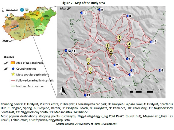
The study area is the central part of Börzsöny Mountains located near the capital, Budapest (see Fig. 2). The volcanic mountains belonging to the Duna-Ipoly National Park is a popular tourist destination due to its variable landscape and romantic forests that can be accessed easily from several directions. Its highest point is the 938 metres high Csóványos while the starting point with the lowest elevation involved in the study is located in the NW margin of the area at 200 metres a.s.l.
The basic conditions of the survey to be presented that differ from those of the referenced researches and from their study areas in certain cases are the following:
▪ the flow conditions of the central part (180 km2) of a larger destination was surveyed and not the movement between the place of residence and the destination or between destinations; especially intradestination patterns were analysed;
▪ due to the natural and infrastructural conditions of the area one-day tours are typical thus their analysis was targeted;
▪ the present publication presents results of a larger study the primary aim of which was to determine the tread of the given routes and to identify tourist types based on the analysis of patterns;
▪ the study area located ~60 km from Budapest is although a popular natural area - apart from Királyrét in the southern edge - it is not a mass-tourism destination;
▪ since the study area is protected the regulations influence movements within it, i.e. there are tourist routes and wandering off these paths (marked trails) is forbidden in strictly protected areas;
▪ considering landscape, the area is a low mountain hiking in which requires no specific equipment or training but the location and orientation of valleys and ridges influence the movement of visitors.
3. A new method of categorizaton
For the identification and categorization of tourist movement patterns appearing in natural environments - considering their importance - a new method was applied.
The movement of pedestrian visitors was analysed in the present study. Detailed data of movement patterns was recorded in the map database only if the visitors hiked for over one hours or to a distance greater than 4 km from the starting point. Due to the conditions of the study area most of these were one-day trips.
Counting lasted for 7 days (5 weekend days and two weekdays) between 2010 and 2012. Two weekend days were in autumn while the rest were in the summer (July and August). The counting was combined with a questionnaire survey carrying out of which was helped by volunteers. Registering the routes took place between 8am and 4pm.
The site of the counting points (see Fig. 2) was selected at intersections near the beginning of the routes running into the inside of the mountains so that all tourist routes could be controlled.
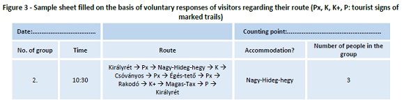
In this way, those hiking in the Central Börzsöny had to cross one of the 14 counting points. Although the central area can be accessed across these points they are not official entry points with gates with counting equipment. Therefore, acquisition of the necessary data was only possible by labour consuming methods, however, this also ensured the complete survey of the patterns appearing in the sampling period. Visitor traffic registering was performed on the basis of voluntary respondents showing the covered routes on a map apart from recording the number of tourists in the group. Accordingly, the following data (Fig. 3) were recorded on the headed sheets with the basic data of the counting (date and location):
In a few cases tracks of the covered route were received in electronic form from the visitors at the end of the day of the visit. In a few cases the tourists arrived without a plan or appropriate maps therefore they planned their route on the basis of the traditional (paper based) maps at the counting point and this was recorded.
It is important to note that not every datum recorded on the map was recorded in the map database. The reasons for this were the following:
▪ tourists did not know where they were going to go accurately (only a few cases);
▪ visitors followed non-marked trails (small ratio in the studied period);
▪ the planned trip was not completed because the tourists returned after 15 minutes;
▪ tourists arrived originally just for a little walk, rambling (without a clear target) realized in the 2-3 km vicinity of the calculation point and lasted for less than one hour;
▪ occasionally the planned trip did not go towards the Central Börzsöny after the calculation point.
Despite this these characteristics were recorded as well because they may yield important information regarding visitor traffic and its management.
Apart from counting the number of visitors and recording the data of tourist routes the tourists were surveyed by a questionnaire as well. They were asked about their habits, knowledge and attitude towards visitor management measures. Results of the questionnaire survey, however, are not involved in the present paper. For the electronic recording of route data, the www.turistautak.hu database established by a collective initiation was used. Segments between intersection points form the base of the database. Intersection points are mainly route junctions, however, any POI (point of interest) can be an intersection point, like springs, resting places, spectacular landforms. Data input, further vectorisation, preparation of maps were carried out using the software QGIS (versions 2.6.1 and 2.18.2).
In the rows of the attribute table (Fig. 4) segments between intersection points can be found (length: s1,2...n) while in the columns the tourist groups are recorded. The name of the columns associated with the tourist groups contain the date of counting, the name of the counting point and the number of the field survey sheet. Accordingly, the column called Z01023KC02 contains the route taken by the second group (02) crossing the “Királyrét, Cseresznyésfa car park” point (KC) on 23rd October 2010 (0/10/23). The route segment completed by the group receives a number equalling the participants in the group (N). If the group covered the same segment forth and back or they went on the same segment several times (three times at the most in the present case) the number of people in the group was multiplied by the number of going (x) along a given segment (Nx). In this phase of data input the number of crossings (x) has not been recorded yet.

Data in the attribute table of QGIS software were copied into Excel for further analysis. Parameters obtained from the questionnaires filled at the counting points were recorded (see Table 1).
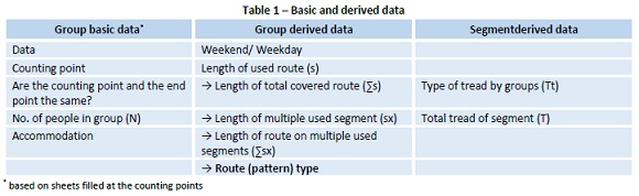
Based on these, it was possible to determine further parameters (derived data) regarding both the tourist groups and the route segments (as shown in Table 1). Considering these further parameters, the total employment (tread, indicated as ‘T’ henceforward) of the given segments and the pattern of the route taken by the groups have greatest significance. Knowing the total tread of the segments is essential in our long-term research as this is the base for carrying capacity analyses.
Identification of the type of the pattern is based on the rate of multiple travelled segments. For this, however, the rest of the parameters in Table 1 have to be calculated.
Derived data related to segments:
· Type of tread of the segment by groups (Tt). This value (x) shows that how many times the particular group moved along the given segment. Tt=Nx:N where Nx is the number of people in the group moved along the given segment recorded in the cells of the attribute table of QGIS, while N is the number of people indicated in the counting sheet. The type of tread by groups could by any number in theory but in the present case a given group moved along the same segment only once, twice or three times at most (Tt=x=1 or 2 or 3).
· Total tread of the segment: number of all tourists moved along the given segment. This can be determined for each segment by summing the numbers of people in the groups moving along the segments. T=N1x1+N2x2+...+Nnxn where N1,N2...Nn is the number of people in groups 1,2,...n moved along a particular segment, x1,x2,...xn is the tread type value (Tt) typical for the given segment.
(Based on the example of Fig. 4, in the case of segments where members of group Z01023KC02 moved along only once, i.e. x=1 and N would be 3 people but there they moved along twice x=2 and Nx=6.)
Derived data related to groups:· Length of used route (s): length of the route used by the tourist group (length of the segment used several times has to be taken into account only once), i.e. s=s1+s2+ +sn.
· Length of total covered route (∑s): sum of the route segments covered by the tourist group (s1,2, ,n) as follows:
∑s=s1x1+s2x2+ +snxn. In this way the segment used several times is calculated several times according to the type of tread (Tt).
· Multiple used length (sx): total length of segments that were used several times by the tourist group, i.e. sx=s1+s2+ +sn, if Tt=x>1.
· Length of route covered along multiple used segments (∑sx): sum of the length of segments (s1,2, ,n) along which the group moved several times (Tt=x>1), so that the length of these segments has to be multiplied as many times as they were covered by the group, i.e. they have to be multiplied by the type of tread (value of Tt):
∑sx=s1x1+s2>x2+ +snxn.
· Route (pattern) type: was identified on the basis of the rate of the route covered along multiple used segments (∑sx) and the total route covered (∑s).
Route pattern typesAs a first step the different patterns were classified into two basic groups based on that whether the starting point (counting point) and the end point of the trip are the same or not. Further categorization was based on the rate of the route covered along multiple used segments (∑sx) and the total route (∑s). Boundaries of the categories were established at 0%, 10%, 50%, 90% and 100% on the basis of the obtained patterns and experience in the practice (see Table 2). Their explanation is given in the following.
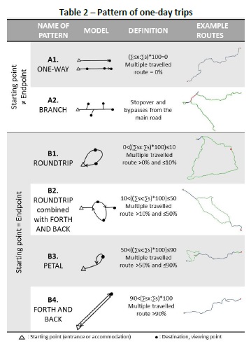
▪ A. Starting point and endpoint are different
- A1. One-way trip: starting and endpoints are not the same (rate of multiple travelled route is 0%), i.e. (∑sx:∑s)*100=0. Potential stopping points and sights are located along the same route therefore there are no bypasses, or segments covered forth and back.
- A2. Branch: starting and endpoints are not the same, but the group takes bypasses from the main route to clearly identified targets. These bypasses could be forth and back or circular loops. This resembles in appearance the STOPOVER types determined by earlier research (Oppermann, 1995, Lau and McKercher 2007) with the difference that the group in our case takes bypasses from a one-way route and not from a forth and back route.
▪ B. Starting point and endpoint are the same
- B1. Roundtrip: starting and endpoints are the same but the trip runs along the same route in a very small rate, 10% at the most (rate of multiple travelled route is 0-10%, i.e. if 0<((∑sx:∑s)*100)≤10).
- B2. Roundtrip combined with forth and back trips: when half of the covered route at the most runs along the same route and the rest form a circular loop (rate of multiple travelled route is 10-50%, i.e. if 10<((∑sx:∑s)*100)≤50).
- B3. Petal type trip: starting and endpoints are the same, but more than half of the total trip runs along the same route (rate of multiple travelled route is 50-90%, i.e. if 50<((∑sx:∑s)*100)≤90).
- B4. Forth and back trip (F&B): starting and endpoints are the same, and almost the whole trip runs along the same route (rate of multiple travelled route is >90%, i.e. 90<(∑sx:∑s)*100).
▪ C. In the case of routes interrupted by staying overnight in the destination (several days’ routes) two further patterns can be identified.
- C1. Touring point to point: Trips lasting for several days with overnight stays in the destination area and with different starting (entry point to the destination), endpoints (exit from the destination) and accommodation points. (If visitors indicated that their accommodation was in the destination area on the survey sheet these trips were categorized.) The overnight stay can be either staying in accommodation or wild camping, bivouacking.
- C2. Stern shape trip: Routes (various types described above) leading to different destinations and returning to the same point. Due to the sampling method (counting points in the margin of the study area, recording one-day trips) and to the location of accommodations (mostly in the margin of the mountains) this trip type was not recorded in the survey.
Apart from the above patterns further ones and combinations were also formed due to the following conditions:
- Accessibility. Several counting points were established in settlements from which several tourist paths started towards the Central Börzsöny: Diósjenő, Királyrét and Nagybörzsöny. As a result, “open roundtrips” occurred where the starting point and the endpoint were not the same counting points but both of them were located in the same settlement.
- Tourist path density. The 1.5 km/km2 density of marked tourist paths (hiking trails) enable the planning of variable routes for trips (e.g. roundtrip with forth and back bypasses).
- Apart from these the location of the most popular destinations makes routes further complex resulting in the occurrence of multiple roundtrips that could be best described by an ‘8 shape’.
This level of categorization, however, seemed unnecessary therefore these special patterns were classified into the categories of the basic pattern types. Furthermore, the routes of “rambling” that correspond to “random exploration” identified in the literature were not vectorised, only recorded in the database. The rate of ramblers contributes to the better description of the visitors at the given starting point.
4. Tourist movement patterns of the study areaCounting points were crossed by 1938 visitors over the studied period. The number of visitors is very different in the 14 counting points. Most popular starting points for hiking are located around Királyrét which is the most well-known area with significant visitor rate (300,000-500,000 visitors/year - based on the personal communication of Királyrét Forestry) (Visitor Centre, car park at Cseresznyésfa). Apart from these a high number of hikers start from Diósjenő which can be accessed easily from the capital. Apparent exceptions are the fourth most popular Királyháza the access to which is not easy and the very low number of visitors of Nógrád which has excellent road and mass transport accessibility (Fig. 5).
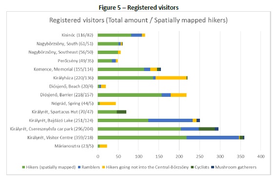
Type and distribution of the counted 1938 visitors by counting points (spatially mapped hikers, ramblers, hikers going not into the Central Börzsöny, cyclists, mushroom gatherers) are shown in Figure 5. It can be seen that the rate of ramblers was highest at counting points associated with Királyrét, apart from them the rate of mushroom gatherers is high (although much lower than that of ramblers).
The movement of 1232 hikers out of the 1938 visitors was surveyed in detail and recorded on a map. The area of the Central Börzsöny has a marked tourist trail network of just over 300 km (302.46 km) 86.25% of which were followed by the trips of the studied period.
4.1 Occurrence of the patternsAs it was mentioned before, all identified pattern types (6 types of one-day and 2 types of several days long trips) have been observed in the study area except for the stern and petal. Seven types were identified during counting (A1, A2, B1, B2, B3, B4, C1). The density of tourist paths and topographic conditions make it possible that trips from the same starting point to the same destination have different pattern, i.e. the visitors have a wide range of choices. Despite this significant rate differences were observed at the particular starting points among the pattern types (Table 3).
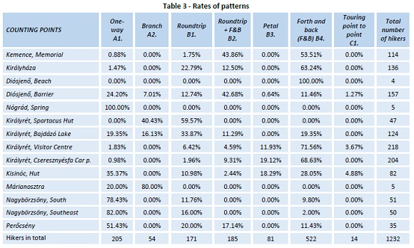
Patterns with different starting points and endpoints (A1, A2, C1, i.e. “one-way, branch, touring point to point”) were typical at the starting points forestry barrier at Diósjenő (51 visitors in total, 32.48%); Nagybörzsöny (South and Southeast; 78.4-82%) and Kisinóc (33 visitors, 40.25% of those starting from here). Apart from these all of the small number of tourists starting from Nógrád counting point covered route pattern A1 (“one- way”) and from Márianosztra only A1 and A2 (“one-way” and “branch”) types of trip were started.
These trip types (A1, A2, C1) require the conscious design of the trip route and the careful planning of accessing and leaving the destination (adjustment of the timetable of mass transport; getting back to the car). This can be the reason of the high rate of these types in the case of Nógrád and Diósjenő that can be excellently accessed by both train and bus. The high rate of pattern A1 in the case of Nagybörzsöny is explained by the one- way travels by the narrow-gauge railway running between Nagybörzsöny and Nagyirtáspuszta.
The most frequent pattern observed in the survey (appeared in the case of 42.4% of the visitors) is the simplest one as well because in the case of the “Forth and back” (B4) type, at least 90% of the trip runs on the same route from the starting point to the destination and back. This type was found not at every counting point: no “forth and back” type trip was started from the least visited counting points (Nógrád, Királyrét, Spartacus Hut, Márianosztra). In contrast, at the two most popular starting points (Visitor Centre at Királyrét and the car park at Cseresznyésfa) this trip was the dominant type (71.56% and 68.63%). At the third most popular starting point, near the forestry barrier at Diósjenő the much more complex “roundtrip + forth and back trip” pattern was typical (42.7%).
Considering patterns returning to the starting point, tourists moving along the same route for several times is least typical for “roundtrip” and “roundtrip + forth and back trip” (in 50% at the most). These two trip patterns were observed typical near the Bajdázó Lake counting point (45% of the observed patterns, 56 people in total) and at the three more northern counting points: Diósjenő (87 people in total, 55%), Kemence (52 people, 45.6%) and Királyháza (48 people, 35.3%).
4.2 Pattern types of tourists starting from the popular tarting pointsBased on the analysis of the trip types at the most popular starting points greatest variety of trip types was found at the points with best accessibility. At least 5 of the above discussed patterns were found at points that can be reached quickly from the capital with several mass transport types, high service density, without or with only a few changes.
· All 7 pattern types were registered only at one counting point at a forestry barrier (closing a tarmac road that crosses the mountains) at Diósjenő. Although this starting point is relatively far (~3 km) from the closes bus or railways station almost one third of the hikers (32.5%) chose trip types requiring mass transport (“one-way, branch, touring point to point”). Rate of the “forth and back” type pattern requiring the smallest grade of knowledge of the area is smallest here (11.46%) regarding the locations presented in Figure 6.

Other, not specified starting (counting) points: 4: Királyrét, Spartacus Hut; 5: Nógrád, Spring; 7: Diósjenő, Beach; 10: Perőcsény; 11: Nagybörzsöny Southeast; 12: Nagybörzsöny South; 13: Márianosztra; 14: Kisinóc
Királyrét is an easily accessible, popular destination where 4 counting points were located. Three out of those are among the top 5 regarding the number of registered visitors (see Table 3). Variability of the patterns at these points is significantly different.
· Most variable patterns are found at the counting point at Bajdázó Lake where not every pattern were found (only five). Trips where the starting point and the endpoint are not the same occurred here in a high rate (35.5%).
· Highest number of hikers started off from the forest school and visitor centre (so called Hiúz House) established at Királyrét and operated by the Duna-Ipoly National Park Directorate in the studied period. The least complex “forth and back trips” requiring neither preparation (e.g. using a map) nor knowledge of the area were most typical here considering both rate and absolute numbers (41.6% of those starting from here, 156 people). On the other hand except for the “branch” type all identified patterns were found here.
· Regarding the counting points at Királyrét the car park at Cseresznyésfa is located furthest from mass transport stops. Almost all visitors registered here (99%) chose trips returning to the starting point. The reason behind this is not necessarily the fact that they had to return to their car left here because many of the hikers (their exact number was not registered) arrived already on foot from the centre of Királyrét (~4 km). The explanation is rather the unpreparedness of the visitors and the lack of knowledge of the area. This is also suggested by the fact that many visitors brought no maps with them, they planned their trip using the one stored at the counting point.
The same patterns occurred at the two most northern counting points of the study area, at Királyháza and Kemence in different rate.
· Királyháza located far from bus and railway stops (~9 km) can be accessed only by car via a forestry road. Despite this, “one- way trips” occurred besides the dominance of trips returning to the starting point (98.54%). Routes of more than third of the tourists starting from here show the complex pattern types of trips returning to the starting point, i.e. the rate of “forth and back trips” is maximum 50%!
· Mass transport connections between Kemence and the capital are moderate (only bus with changes under 125 minutes) and due to its distance from the capital travel time is long as well (87 minutes). This is why most of the visitors registered here stayed at Kemence for the night (outside the study area). Thus the high rate of routes returning to the starting point (99.12%) is not surprising. More than half of the hikers (53.51%) took the simplest pattern within this, “forth and back trips”.
5. ConclusionsStudying the movement of tourists and understanding visitor flow conditions provide the basis for the visitor management of natural areas and national parks. On the one hand, it helps to determine the employment of particular areas and its differences. On the other hand, pattern types are in close correlation to tourist types the understanding of which may improve visitor management efficiency.
Pattern analysis and their parameter system in the literature cannot be applied to movements in natural environments in Hungary or the described pattern types cannot be identified due to objective reasons.
This is why in the present study tourist flow patterns were identified with mathematical methods, patterns were defined accurately and observed in a given study area. In the presented method the identification of patterns is based on the rate of the back-and-forth and the multiple travelled routes.
Eight major patterns were identified 6 of which characterises one-day trips. The two main categories of one-day trips can be identified based on whether the starting point and the endpoint (where the tourist leaves the destination or the study area) of the trip are the same or not. Further types can be identified on the basis of the rate of back-and-forth routes. Trips from the starting point to different endpoints can be “one-way” or “branch” type if bypass is taken by the tourist. Among patterns returning to the starting point “roundtrips” are characterised by the smallest rate of multiple used route segments (max. 10%). If the rate of multiple used route segments is greater than 10%: “roundtrip combined with forth and back trips” (10% <used route segment≤ 50%) or “petal” (>50%) or “forth and back” (>90%) types are identified.
The smallest the rate of multiple travelled routes is the newer impulse the tourist will experience and the higher rate of the area will be known by the visitors. Avoiding repeats in the trip, however, requires higher level of planning or more detailed knowledge of the area or the use of necessary sources of information (maps for example).
There can be different types of tourists in a destination. This can be observed in the various movement patterns as well the characteristics of which (presence/absence, rates) provide information on the tourists of a given area (of the starting point in the present case).
In the course of this study 7 out of the defined 8 patterns could be identified in a destination (Central Börzsöny) located close to the capital of Hungary. Based on the analyses, the area of the Mountain with greatest number of visitors (Királyrét) is a popular starting point for hikers as well. At the two most well-known starting point the most typical pattern type was the “forth and back trip” (B4) showing the smallest rate of variability. In contrast the most variable “one-way” and “roundtrip” types were typical in the case of hikers starting from points far away from the capital in the northern (Diósjenő, Királyháza) and western (Nagybörzsöny) margin of the study area.
The survey and its results could give the basis for a more effective and variable visitor management considering the different target groups of the starting points in the future.
REFERENCES
Arrowsmith, C., & Chetri, P. (2003). Port Campbell National Park patterns of use: A report for the development of visitor typology as input to a generic model of visitor movements and patterns of use. Melbourne, Victoria, Australia: Parks Victoria Visitor Research. Retrieved from https://www.researchgate.net/publication/255670433_A_report_for_the_development_of_visitor_typology_as_input_to_a_generic_model_of_visitor_movements_and_patterns_of_use
Andersen, O., Gundersen, V., Wold, L. C., & Stange, E. (2012). Counting visitors in alpine areas: how sensor range, clothing, air temperature and visitor volume affects passive infrared counter accuracy. In P. Fredman, M. Stenseke, H. Liljendhal, A. Mossing, & D. Laven (Eds.) Outdoor recreation in change - current knowledge and future challenges. Paper presented at the Proceedings of the 6th International Conference on Monitoring and Management of Visitors in Recreational and Protected Areas, Stockholm (30-31). Retrieved from http://mmv.boku.ac.at/downloads/mmv6-proceedings.pdf
Beeco, J. A., Huang, W. J., Hallo, J. C., Norman, W. C., McGehee, N. G. McGee, J., & Goetcheus, C. (2012). GPS tracking of travel routes of wanderers and planners. Tourism. Geographies, 15(3), 551-573. Retrieved from http://www.tandfonline.com/doi/full/10.1080/14616688.2012.726267?scroll=top&needAccess=true [ Links ]
Beeco, J. A., Hallo, J. C., English, W. R., & Giumetti, G. W. (2013). The importance of spatial nested data in understanding the relationship between visitor use and landscape impacts. Applied Geography, 45, 147-157. [ Links ]
Cessford, G., & Muhar, A. (2003). Monitoring options for visitor numbers in national parks and natural areas. Journal for Nature Conservation, 11, 240-250. [ Links ]
Cohen, E. (1972). Towards a sociology of international tourism. Social Research, 39(1), 164-189. [ Links ]
Debbage, K. (1991). Spatial behavior in a bahamian resort. Annals of Tourism Research,18(2), 251-268. [ Links ]
Eagles, P. F. J., & McCool, S. F. (2004). Tourism in national parks and protected areas: planning and management. CABI Publishing. [ Links ]
Flognfeldt, T. Jr. (1999). Traveler geographic origin and market segmentation: The multi trips destination case. Journal of Travel & Tourism Marketing, 8(1), 111-124. https://doi.org/10.1300/J073v08n01_07 [ Links ]
Flognfeldt, T. Jr. (2005). The tourist route system - models of travelling patterns. Belgeo, Revue belge de géographie, 1-2. http://dx.doi.org/10.4000/belgeo.12406 [ Links ]
Gao, J. H., Hsueh, Y. H., Liu, Y. W., Lee, H. G., & Huang, J. Y. (2013). Exploring the relationship between tourist’s types and travel path patterns in Dong-Gang area of Taiwan. Paper presented at The Asian Conference on Arts & Humanities 2013, Osaka, Japan (215-220). Retrieved from http://papers.iafor.org/conference-proceedings/ACAH/ACAH2013_proceedings.pdf
Gao, J. H. & Hsueh, Y. H. (2014). Exploring the Relationship between traveler types and travel route types. International Journal of Basic and Applied Sciences, 14(02), 48-56. [ Links ]
Hall, M. C. (2012). Spatial analysis: A critical tool for tourism geographies. In: J. Wilson (Ed.), The Routledge handbook of Tourism Geographies (163-173). London, New York: Routledge. [ Links ]
Kádár, B. (2014). Pedestrian space usage of tourist-historic cities (Ph. D thesis). Budapest University of Technology and Economics. [ Links ]
Kajala, L., Almik, A., Dahl, R., Dikaitė, L, Erkkonen, J., Fredman, P., Jensen, F. Søndergaard, Karoles, K., Sievänen, T., Skov-Petersen, H., Vistad, O. I., & Wallsten, P. (2007). Visitor monitoring in nature areas - a manual based on experiences from the Nordic and Baltic countries. Sweden: Alfa Print. (ISBN: 91-620-1258-4) Retrieved from https://www.naturvardsverket.se/Om-Naturvardsverket/Publikationer/ISBN/1200/91-620-1258-4/
KSH (Központi Statisztikai Hivatal [Hungarian Central Statistical Office]) (2016). Settlements in Hungary by legal status, 1 January 2016. Retrieved from https://www.ksh.hu/regional_atlas_administration_structure?lang=en [ Links ]
Lau, G., & McKercher, B. (2007). Understanding tourist movement patterns in a destination: A GIS approach. Tourism and Hospitality Research, 7(1), 39-49. [ Links ]
Lew, A. A., & McKercher, B. (2002). Trip destinations, gateways and itineraries: the example of Hong Kong. Tourism Management, 23, 609- 621. [ Links ]
Lew, A., & McKercher, B. (2006). Modeling tourist movements. A local destination analysis. Annals of Tourism Research, 33(2), 403-423. [ Links ]
Liu, C. H., Chu, T. H., Lin, M. L., & Chang, C. H. (2013). Exploring spatial pattern of tourist behavior using geographic information techniques. Paper presented at 1st International conference on environmental informatics. Kuala Lumpur, Malaysia. (ISBN: 978-1-61804-175-3) Retrieved from http://www.wseas.us/e-library/conferences/2013/Malaysia/RESEN/RESEN-57.pdf
Lue, C.C., Crompton, J.L., & Fesenmaier, D.R. (1993). Conceptualization of multi destination pleasure trips. Annals of Tourism Research, 20, 289- 301. [ Links ]
Manning, R. E. (2002). How much is too much? Carrying capacity of national parks and protected areas. In A. Arnberger, C. Brandenburg, & A. Muhar (Eds.), Monitoring and management of visitor flows in recreational and protected areas conference proceedings. Bodenkultur University, Vienna, Austria, 30 January - 02 February (pp. 306-313). [ Links ]
McKercher, B., & Lau, G. (2008). Movement patterns of tourists within a destination. Tourism Geographies 10(3), 355-374. [ Links ]
McKercher, B., & Lew, A. A. (2004). Tourist flows and the spatial distribution of tourists. In A. A. Lew, C. M. Hall & A. M. Williams (Eds.), Companion to Tourism. (pp. 36-48). London, Blackwell. [ Links ]
Meijles, E. W., de Bakker, M., Groote, P. D., & Barske, R. (2014). Analysing hiker movement patterns using GPS data: Implications for park management. Computers, Environment and Urban Systems, 47, 44-57. [ Links ]
Michalkó, G., Kádár, B., Gede, M., Balizs, D., Kondor, A. Cs., & Ilyés, N. (2016). A budapesti agglomeráció szatellitturizmusának környezeti hatásai. In T. T. Sikos & T. Tiner (Eds.), Tájak, régiók, települések térben és időben: tanulmánykötet Beluszky Pál 80. születésnapjára. (pp. 241- 257) Budapest, Dialóg Campus Publisher.
Mings, R. C., & McHugh, K. E. (1992). The spatial configuration of travel to Yellowstone National Park. Journal of Travel Research, 30(4), 38-46. [ Links ]
Muhar, A., Arnberger, A., & Brandenburg, C. (2005). Monitoring of visitor flows and visitor needs as a basis for protected area management. Paper presented at the Conference Volume of 3rd Symposium of the Hohe Tauern National Park for research in protected areas. Kaprun, Salzburg (153-157). Retrieved from http://www.zobodat.at/pdf/NP-Hohe-Tauern-Conference_3_0153-0157.pdf
Newsome, D., Moore, S. A., & Dowling, R. K. (2007). Natural area tourism: ecology, impact and management. Clevedon: Channel View Publications. [ Links ]
Nickerson, N. P., Bosak, K., & Zaret, K. (2009). Nonresident travel patterns between glacier and Yellowstone National Parks. (Research report) Institute for Tourism and Recreation Research. University of Montana. Retrieved from http://scholarworks.umt.edu/cgi/viewcontent.cgi?article=1090&context=itrr_pubs [ Links ]
Oppermann, M. (1995). A model of travel itineraries. Journal of Travel Research, 33(4), 57-61. [ Links ]
Oppermann, M. (1997). First-time and repeat visitors to New Zealand, Tourism Management, 18(3), 177-181. [ Links ]
Oranella, D., Bregt, A. K., Ligtenberg, A., & Wachowicz, M. (2012). Exploring visitor movement patterns in natural recreational areas. Tourism Management, 33, 672-682. [ Links ]
Orsi, F., & Geneletti, D. (2013). Using geotagged photographs and GIS analysis to estimate visitor flows in natural areas. Journal for Nature Conservation, 21(5), 359-368. [ Links ]
Plog, S. C. (1974). Why destination areas rise and fall in popularity. Cornell Hotel and Restaurant Administration Quarterly, 14(4), 55-58. [ Links ]
Plog, S. C. (2002). The power of psychographics and the concept of venturesomeness. Journal of Travel Research 40(3), 244-251. [ Links ]
Puczkó, L., & Rátz, T. (2000). Az attrakciótól az élményig: a látogatómenedzsment módszerei. Budapest: Geomédia Szakkönyvek. [ Links ]
Rettie, K. (2012). Monitoring human use on trails in Canada’s mountain national parks. In P. Fredman, M. Stenseke, H. Liljendhal, A. Mossing, & D. Laven (Eds.) Outdoor Recreation in Change - Current Knowledge and Future Challenges. Paper presented at the Proceedings of the 6th International conference on monitoring and management of visitors in recreational and protected areas, Stockholm (92-93). Retrieved from http://mmv.boku.ac.at/downloads/mmv6-proceedings.pdf
Rupf, R., Wernli, M., & Haller, R. (2008). How to elaborate precise visitor numbers? In A. Raschi & S. Trampetti (Eds.), Management for protection and sustainable development. Proceedings of the Fourth International Conference on Monitoring and Management of Visitor Flows in Recreational and Protected Areas. Montecatini Terme, Italy (pp 161- 164).
Shoval, N., & Isaacson, M. (2007). Tracking tourists in the digital age. Annals of Tourism Research, 34(1), 141-159. [ Links ]
Smith, V. L. (Ed.) (1989). Hosts and Guests. The Anthropology of Tourism (2nd ed.). Philadelphia: University of Pennsylvania Press. turistautak.hu (2016). [Hiking trails] Retrieved from http://www.turistautak.hu/ [ Links ]
Zakrisson, I., & Zillinger, M. (2012). Emotions in motion: tourist experiences in time and space. Current Issues in Tourism, 15(6). Retrieved from https://lup.lub.lu.se/search/publication/ab60ee9b-1d86-43d1-97fc-82e9bde8811b [ Links ]
Zoltan, J., & B. McKercher (2015). Analysing intra-destination movements and activity participation of tourists through destination card consumption. Tourism Geographies, 17(1), 19-35. [ Links ]
Guest Editors:
· J. A. Campos-Soria
· J. Diéguez-Soto
· M. A. Fernández-Gámez
Received: 24.08.2017
Revisions required: 15.12.2017
Accepted: 16.05.2018

