


 Inglês (pdf)
 Artigo em XML
 Referências do artigo
 Enviar este artigo por email
 Citado por SciELO
  Similares em
SciELO
Similares em
SciELO 
 Permalink
1. Introduction
The dynamics and effects resulting from land use have been central to an intense disciplinary debate for years (Lambin et al., 2001; Barton, 2009; Kim, 2011; van Schrojenstein Lantman et al., 2011; Stephens et al., 2019) which has led public opinion as well as international governments to take action to defend such a difficult resource to renew (Doran & Safley, 1997; Blum, 2005), which is also fundamental for the balance of our ecosystems.
One of the most investigated topics in this field of research for planning purposes has been the gradual covering of agricultural soil in favour of urbanised land which has catalysed territorial policies towards the notion of land cover, specifically the difference betweenpermeableandimpermeablesoil. This is only a partial definition of land use as its official definition (FAO, 1999) refers to any kind of human modification to soil made in order to change its use from its wild or untouched previous natural state. Due to the broad meaning of this definition, a synthesis of the transformation factors necessary for analysis and regulation is necessary. Of these factors, the phenomenon of soil degradation due to intensive agricultural and cropping practices is a matter of growing interest (Montanarella, 2007). If on the one hand improvements have been made in mitigating the impact of certain cropping methods, on the other hand it is still necessary to define broader conversion strategies to transform agricultural areas into multifunctional landscapes (Stürck et al., 2018) with a higher degree of resilience to the effects of climate change.
In these terms, recognising the importance of the eco-systemic function of wetlands (Zedler & Kercher, 2005; Robertson, 2004; Maltby & Acreman, 2011; Georgiou & Turner, 2012) in the last decades has led to the preservation of many habitats that were historically considered to be unhealthy and barren, or generally associated to the concept ofwasteland(Richardson, 1983; Di Palma, 2014).
Nevertheless, the chance to establish a new balance between such wetlands and agriculture faces several cultural and socio-economic hurdles. The first being that land reclamation in many countries has covered a crucial role in the process towards modernity and progress, and contributed to the wealth and safety of whole populations; which is why the idea of reverting to a landscapes characterised by wetlands raises doubts about its viability as well as being seen by governments and authorities in charge of territorial planning as an inversion, if not a defeat. Similarly, although wetlands could bring undeniable benefits, it is hard to envisage and plan new models of land occupation and use, as well as local resource profitability for these kinds of habitats.
This study aims to demonstrate how not only is the restoration of wetlands an environmental priority but also an opportunity to make new land assets more coherent with soil properties. The research examines peatlands as, more than other wetland typologies, they have been subject to degradation phenomena that can be directly linked to industrial agriculture and forestation.
The proposal develops a selective deforestation and environmental regeneration plan aimed at gradually creating a new water landscape based on the real vocation of soils, with the goal of developing a different, more sustainable ecological condition for the Isle of Skye in Scotland.
The research intends to identify a feasible strategy to take advantage of the touristic potential of the landscape in order to redirect, via a gradual ecological transition, financial interest from timber farming - which has a devastating effect on this kind of habitat - towards less invasive forms of land use.
As many authors have duly noticed, the return to a wild natural condition in contexts such as the mentioned one is both biologically and socio-economically unlikely and hardly feasible (Harris et al. 2006; Choi 2007; Seastedt et al. 2008). In line with this assumption, the article suggests a pragmatic and unconventional approach by proposing the concepts ofhybridandnovel ecosystems(Hobbs et al. 2006; Mascaro et al. 2013) as a theoretical background for new biotopes that are coherent in properties and eco-systemic functions to, while at the same time being clearly distinguishable from, the previous conditions. The proposed plan associates this reconfiguration process to define new balances of the habitats with a gradual transformation in land use, as well as recognising the need for anthropic intervention in preserving, managing and valorising the touristic vocation of the landscape.
2. Isle of Skye: assumptions and methods for an ecological transition
The study begins by analysing through the scientific literature the main ecological and environmental issues connected to the degradation of peatlands. It then moves on to examine the factors that most influence this process in the case-study of the Isle of Skye (Fig. 1) and which methodologies can intervene to define a new balance between uses and the health of the soil. The proposal, as a result ofresearch by design, entails both planning and landscape design scales of intervention to set strategies and specific actions aimed at restoring the wetlands, where possible, and creating new coherent ecosystems for touristic use.
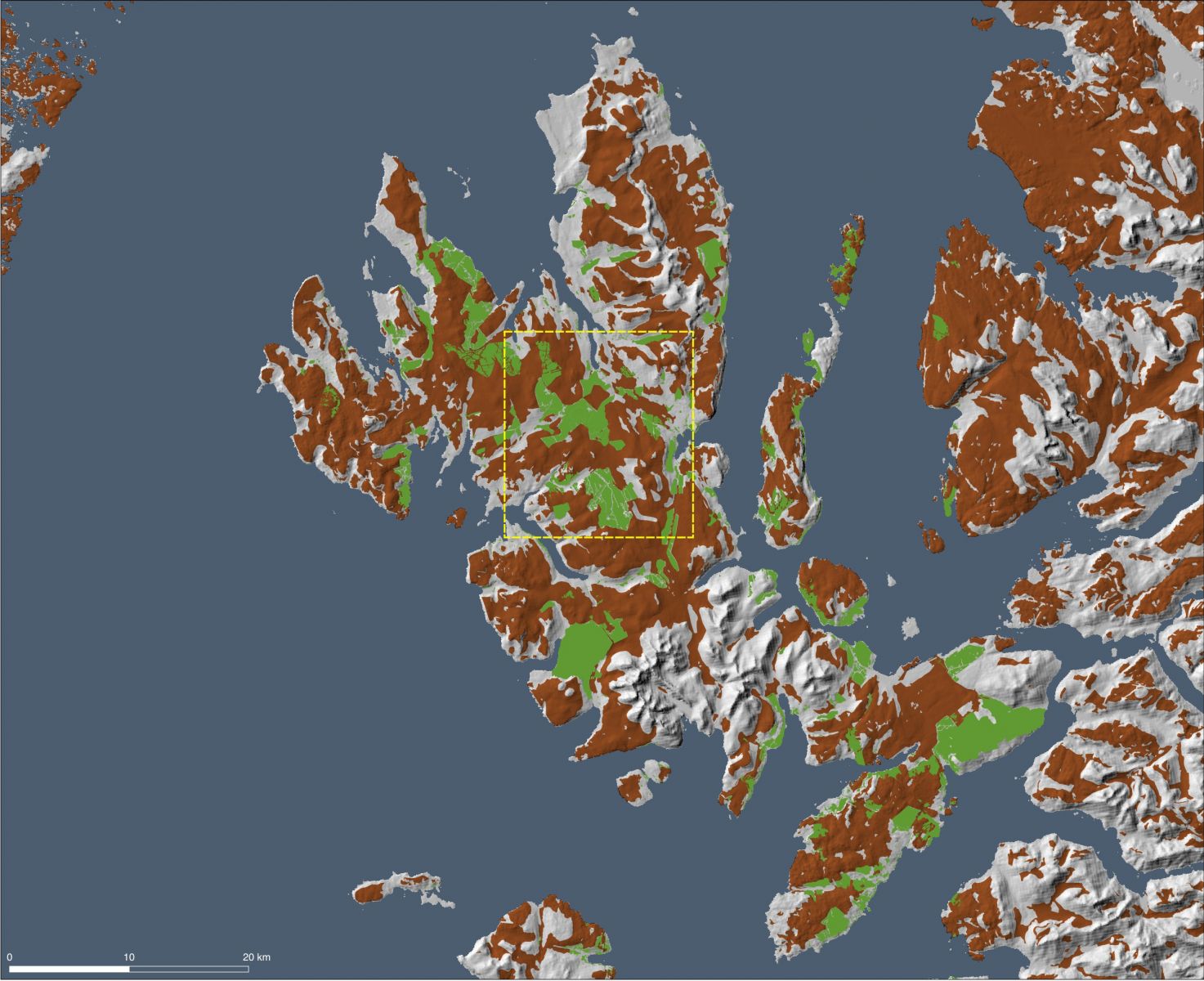
Source: photo by the author (2019).
Fig. 1 The image shows the peat soils' distribution (in brown) and the current commercial forests (in green) on the Isle of Skye in Scotland. The yellow quadrant locates the case-study area.
2.1 Character and importance of peatlands
Peatlands are ecosystems with an abundance of slow-moving water at a low temperature. These humid and cold environments are rich in acid substances due to bacteria being prevented from carrying out their natural function of degrading organic material.
For this reason, the biological life-cycle of plants, insects and animals in the area produces material that does not fully decompose but that rather tends to accumulate in layers, creating what is known as peat; this characteristic soil must have at least 30% of organic content to be considered as such (Joosten and Clarke, 2002). Peat is active as long as the sedimentation process of the organic layer is taking place; class 1 peat has an organic layer of over 50 cm while class 2 peat has a layer of between 35 and 50 cm.
The benefits of preserving the humid environment of peatlands are many. As well as being extremely rich in biodiversity, they have a vital role in the phytoremediation and refill of superficial ground water, thus reducing hydrogeological risk as a result of their natural quality of acting as detention basins. Their existence also has effects on atmospheric pollution as they are substantial containers of CO2. In fact, the dangers connected to damaged peatlands are more substantial than the benefits they might have to the environment: peat is extremely unstable and when water is removed from the pores in the ground oxygen reaches the lower layers of organic material, triggering chemical reactions that, aside from CO2,can produce dangerous quantities of MH4(methane) and N2O (nitrous oxide). Estimates show that peatland drainage processes add up to 5,6% of global greenhouse-gas emissions from human activities (Morison et al. 2010).
2.2 Assessment of risk and potentials of the site
Peatland degradation in many countries is rising to worrying proportions and causing at times permanent damage. In the UK alone over the last 10 years, 190.000 hectares of class 1 peat and 315.000 hectares of class 2 peat have been drained and transformed into agricultural land or woodlands. A large proportion of these are in the Highlands, which include the Isle of Skye. Due to climatic and geological reasons, the so-calledblanket bogscover the valley-scored topography of these lands and constitute a peculiar and precious kind of peatland specific to this latitude, which is an endangered and frail natural heritage of unique environmental and landscape importance (Fig. 2). According to Aspinall et al. (2011)’s report, at least 50% of these blanket bogs shows signs of deterioration due to drainage operations or bad management, which endanger around 20.000 ha of peatland yearly. Our study focuses on two main critical aspects connected to soil degradation on the isle of Skye: the vast forestation plan that is draining the peatlands over the whole territory and the damage inflicted by unregulated and substantial tourism.
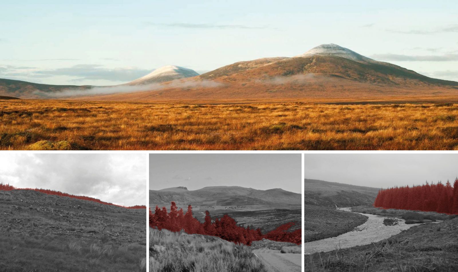
Source: photos by the author (2019).
Fig. 2 The illustration on the top shows the blanket bogs landscape featuring a well-preserved area of the project's site. While, in the three images below, the woodland farming interfering with the peatlands' landscape are highlighted in red
In the last decades, the island has been subject to exceptionally aggressive forestation politics: according to the most recent survey (Aspinall et al. 2011) native broadleaf trees are only 20% while the rest of the 49.000 ha of woodlands are destined to the production of conifers. As of today, 69 of the 176 blanket bog fields on Skye have been planned as new forestation zones. In these areas, preparatory interventions on the sublayer of vegetation that will host commercial tree farms entail earthwork operations as well as the use of fertilisers that upset the chemical composition and structure of the soil.
Once the conifers are planted, they further aggravate the condition of peat: the roots dry out the soil by absorption while deep ramification can cause fractures in the terrain that prevent water from stagnating and causing it to move down towards deeper layers.
As the overall hydrodynamic asset is modified, this degradation process does not only affect new forestation zones but also neighbouring peat areas that are often subject to constant deterioration due to unregulated and violent land exploration.
Skye is invaded by over 100.000 tourists a month during the summer period although only less than 10.000 people are actual residents. 18,3% of total travellers (Global tourism Solutions, 2017) visit for wildlife tourism purposes, as part of a growing and recurrent trend throughout the Highlands. Unfortunately, the island is not sufficiently equipped yet to manage this inflow and direct it towards a more conscious and respectful fruition of the natural landscape. The inadequacy and shortage of services, trails and itineraries in these specific and delicate environmental conditions turn what could be a great opportunity for sustainable development into a risk.
How nature tourism could become a very profitable market for the area both in terms of income and occupation has in fact been extensively documented (Curtin, 2013), as it would be a more viable alternative to wood production. Data is clear: in the whole region in 2016 alone, 706 million pounds were earned from tourism, with 498 million of these being connected to nature tourism; at a national scale, the yearly market trade volume for wood production is 771 million (Forestry Statistics, 2016). Comparing these numbers and assessing the relative impacts of the two markets on the environment shows that a transition towards new financial programmes for the restoration of the peatlands rather than their destruction would be strategically viable.
This study investigates which criteria should be followed to activate this process and instate a two-way relationship between landscape preservation and land use.
3. Settings and criteria of the plan’s methodologies
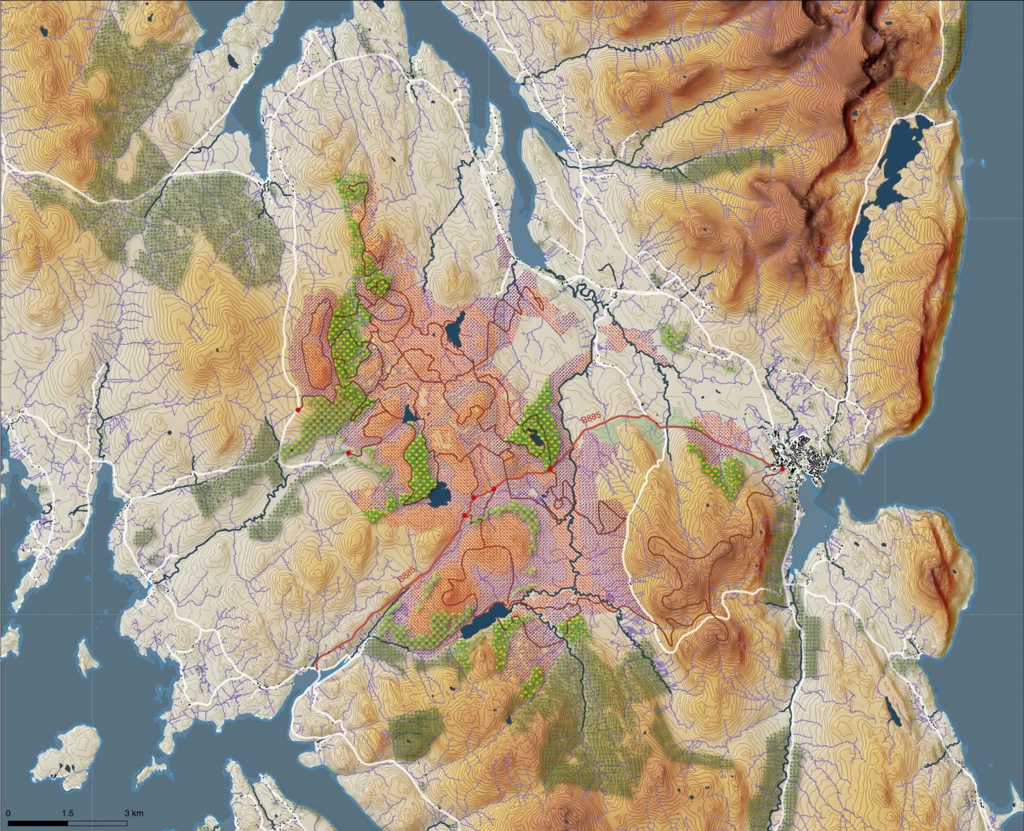
The selected area as a case-scenario for the study is in inland Skye along the coast-to-coast road B885 from the town of Portree to the cliffs of Struan in the north of the island. Despite being a connection between two tourist centres, the road is mostly used by residents and to transport wood produced in three of the biggest intensive forestation sites on the whole island. The study is focused on a vast area characterised by high and low plateaus with four lake systems (Fig. 3). Active peatlands here are what is left of a forest covering over a total 2.254 ha of land, 22% of which is class 1 peat. The lack of care, interest and preservation of this site is the result of almost total lack of inhabitants and visitors, although the touristic potential of the landscape is very high. For this reason, the proposal to transform the site is based on an extremely pragmatic intervention methodology that intends to quickly activate a mechanism in order to prompt fruition of the area, which can both act as an ecological safe-zone and an economic trigger for the various phases of the implementation process.

Source: photo by the author (2019).
Fig. 3 Actual situation of the case-study area. The B88s road is highlighted in red, while, in green, are displayed the commercial forests.
The criteria chosen to direct the transformation interventions on the landscape are the outcome of a careful analysis of the current soil and peat conditions, as well as of the several morphological characteristics of the site (Anderson, R., 2010; Cris et al., 2011; Artz, 2014). The evaluation of pooled data (Fig. 4) has led to the classification of the area into 4 types of homogeneous zones, called priority areas, which are ranked from 1 to 4, depending on the amount of time needed to stop degradation phenomena and to become part of a tourist itinerary. This has produced an accurate map of possible ecological pattern development as a basis for a deforestation strategy and a gradual transition from current intensive land exploitation to touristic use (Fig. 5).
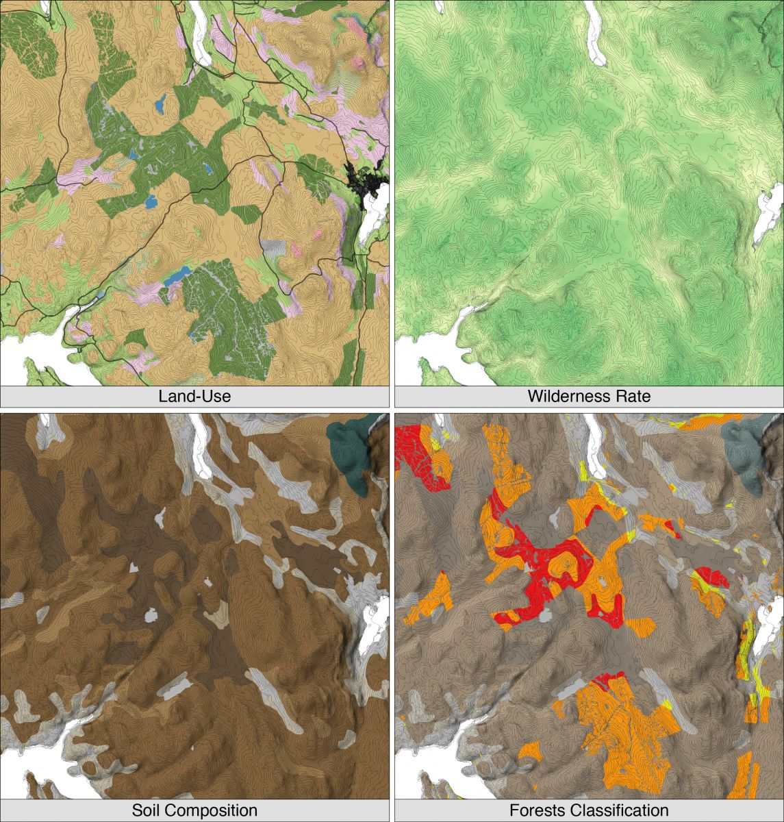
Source: photos by the author (2019).
Fig. 4 Four different analyses of the area showing the spatial relationships between land-use, soil composition and landscape features. Below, on the right, the existing commercial forests are classified according the the class of peat they cover: in red and orange, respectively the forests laying on class I and II peat soils; in yellow, the commercial forest outside the peat.
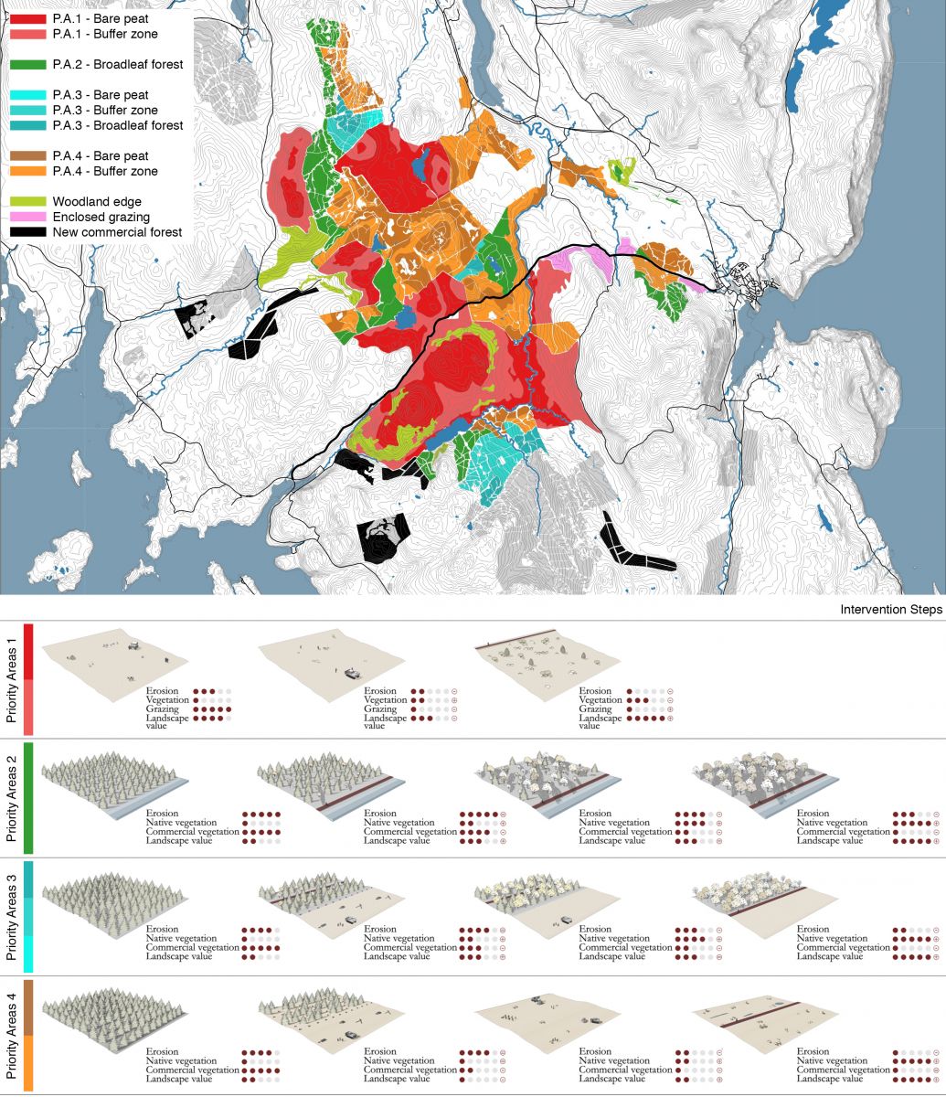
Source: photos by the author (2019).
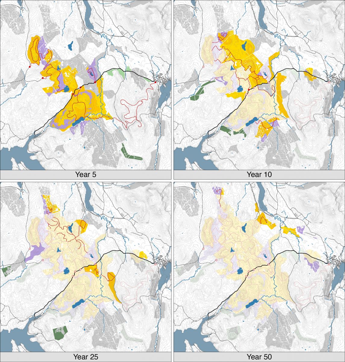
Fig. 5 Above, the management plan showing the layout of the 4 different Priority Areas and the additional intervention zones. Below (image by Merlante and Valmassoi, 2017), the evolution through the time of landscape in the Priority Areas.
First-class priority areascorrespond to non-forested terrains that present little superficial erosion, mostly because of the unregulated transit of people and animals. These necessitate quick and non-invasive restoration of the top layer of peat. Depending on the location of these operations, two main biotopes will be formed: certain sectors will consist ofbare peat, such as hilltops or more accentuated depressions that will be flooded; in the remaining areas, shrubs and bushes will be planted coherently with the wet ecosystem, as a planned buffer zone.
Second-class priority areasare those where peat has been damaged the most, if not permanently, by the erosion of conifers, exposure to south-western winds or the transiting of trucks for wood harvesting. As a thorough restoration of these wet ecosystems in these areas is unlikely, a gradual deforestation process is foreseen, that is cutting conifers and replacing the species with native broadleaf trees.
Third-class priority areasare also mostly covered by conifers but differ as their environment is less dry because of punctual morphological configuration and brooklets that allow the water cycle to regenerate degraded peat. This condition requires a combined action of the previously described interventions: from reforestation of higher ground with broadleaf trees to the creation of buffer zones through the decay of shrub vegetation in humid bare peat areas.
Fourth-class priority areascorrespond to the woods with higher concentration of class 1 peat that present good erosion conditions. Here, a renewed water cycle is still feasible and thus necessary thanks to favourable geomorphological features, although interventions are more complex in terms of time, cost and labour.
In fact, this will consist in eradicating all conifers and filling the cracks created by this operation. Once deforestation has been achieved and soil conditions monitored, the same regeneration measures as those for first-class priority areas will be activated.
Aside from these areas, the plan locates other zones where peat is not present or where the level of decay is too advanced to propose agriculture or pasture. For these sections, in order to avoid the loss of income from stopping the production of wood, some form of compensation is planned until total transition towards a more sustainable and profitable touristic model has taken place.
4. Expected results of the conversion plan
Through the described approach, the study proposes a management plan for the area (Fig. 6) that will achieve approximately a 60% decrease in greenhouse-gas emissions from peat degradation over a 50-year timeframe.
Achieving this goal entails a programme of interventions through a set of defined steps (Fig. 7). Within five years from the start of operations, all first-class priority areas will have been secured and neighbouring second- and third-class priority areas will have completed the conifer replacement process. The longest and most complex peat-restoration interventions of third- and fourth-class priority areas will instead be more gradual and based on their relationship with the location of tourist trails. In this way, over a ten year timeframe, the first vast area to be thoroughly deforested will be that between Loch Ravag, Loch Connan and Loch a’ Ghlinne Bhig which will be converted into a humid bare peat area, while woods further away from touristic itineraries will begin to be transformed. At this stage, the entirety of the trail-network will be already active and visitors will be able to follow the development process of the territory that will in the meantime gradually spread to more peripheral areas. After twenty-five years, many native replanted species will have reached maturity and deforestation of the remaining two areas of the transformation process will commence. Fifty years after the beginning of works, a completely new landscape will emerge: the bare peat areas and shrub-vegetation peat areas will be reclaimed, the conifer forests will have been replaced by native broadleaf vegetation and the trails will create a 50 km-long itinerary that from Portree leads across the inland areas of the island.
Source: photos by the author (2019).
Fig. 6 The management plan layout as it should be at the end of the landscape transformation process.
Source: photos by the author (2019).
Fig. 7 Chronological development of the reconversion plan. In orange and yellow, the areas to be reconverted in bare peat and buffer zones; in violet, the new forests planted with native broadleaf trees; in light green, the enclosed grazing areas; and in dark green, the new commercial forests.
During such a long and complex process, it is vital to assist the changes to the environment with strategic planning that mutually benefits human activities and the development of the habitat, so that a new eco-systemic bond between man and nature can be established. With this goal in mind, the study envisages an accessibility and touristic system that, after its creation, can develop as a function of the different conversion phases the landscape will be subject to, of the most fragile zones that are in need of preservation and, finally, to cement the bond with the landscape through the direct experience of the natural heritage.
The supporting infrastructure of this system comprises a network of trails that is designed based on specific kinds of users and is articulated along 5 different itineraries, each of which recalls different categories of nature tourism: didactic, wildlife tourism, landscape tourism and hill trekking. The layout is a consequence of the existing tracks used by the wood industry, that will be used initially during the regeneration and deforestation works, and then be turned into pedestrian routes to be implemented with other new trails. Every track will have several access points from the road system, especially road B885; each entrance will provide car and bicycle lay-bys, small information, didactic and commercial facilities.
The programming for the realisation of the trails and the schedule of operations for the priority areas mutually follow and benefit each other, thus integrating touristic and environmental functions from the very beginning. Within the first 5 years from the start of works, one visiting system will have been completed south of road B885, around the biggest bare peat zone of the area. As it will be connected directly to Portree, it has the twofold function of attracting and regulating the tourist inflow from the coast as well as raising awareness of the functioning of the whole ecosystem. The first of the two itineraries starts from the town in the direction of a series of scenic vantage points over the landscape at the top of neighbouring hills. The second goes west over flatter land and has great didactic potential: in fact, the trails are made of a simple wood structure connected to the ground and visitors will be able to witness the different regeneration phases of the peatland by joining in the less complex activities of the process together with specialised workers.
These activities include the easier interventions such as removing the first eroded layer of peat - that, due to its advanced state of decay, would otherwise carry on emitting polluting gases - or filling the cracks left over by the eradication works with more peat or sawdust to prevent the organic layer from oxidation. After this, it is necessary to encourage water to stagnate through the creation of small dams or terraces so as to restore the correct hygrometric values that will help peat moss and cotton grass to grow: in wetlands this kind of species are vital to the regeneration of its water system.
On slopes and in transition areas between one ecosystem and the other, where the level of stagnating water is noticeably lower, structural reinforcement of the slopes is planned by planting low density vegetation, suitably to a wet environment (i.e. heather, mountain willow, blackthorn and asphodels), overgeojutasheets.
The three itineraries to the north of road B885 will cross similar but more varied ecosystems. The layout of these tracks will change in time and only be definitive around the tenth year from the start of works; this is because the planned interventions for these areas are longer and more complex. This dynamic allows visitors to follow the development and changes in the vegetation, especially in terms of witnessing the woods destined to commercial use being replace by native broadleaf trees. In the initial phase, in fact, the trails will be restricted to the inside of those conifer woods that will gradually go through deforestation, in order to help planting activities and growth of the native trees that will shortly after become predominant. The goal is to hide to the eye of visitors the most invasive deforestation and peat regeneration processes that will in the meantime be running in parallel in the neighbouring areas. Once the re-qualification works on the peatlands is concluded, the track will be partially moved to the so-calledwoodland edges: habitats where biodiversity thrives and tourists can have a clear view of the transition between the two ecosystems.
By the tenth year, two new broadleaf woods will grow in the northern area: the first will range all across the western side and function as a barrier against predominant south-western winds in order to reduce their negative effects on the regeneration process of the peatlands; the second, closer to the B885, will become the eastern border of the works and access on that side to touristic facilities.
In the two woods different thematic itineraries will enable tourists to discover a territory that presents a new combination of landscapes and ecosystems (Fig. 8). The tour around Loch a’ Ghlinne Bhig is almost entirely immersed in the woods and planned mostly with didactic purposes: despite its 4 kms it is the easiest track to walk along and shows the most important biotopes of the surrounding environment in the least amount of time. The itinerary around Loch Ravag and Loch Connan, on the other hand, is 11,4 km long and is intended for birdwatching and observation of the characteristic wildlife: the track is designed in order to run along the most transitions between eco-systemic zones as possible, such as woodland edges or peat areas with shrub vegetation. Finally, the north-western itinerary was designed for users wanting to admire the scenic views and landscapes that have turned Skye into such a popular destination: the trail is 12 km long and runs to the top of three hills with views all the way to the western fjords of the island.
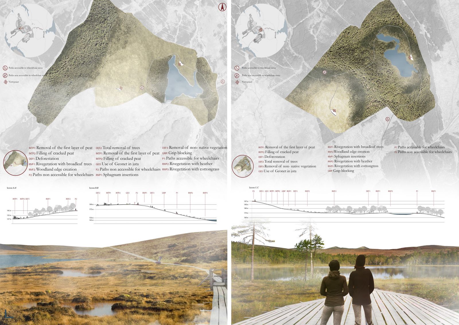
Overall, the trail system will also be accessible by users with reduced mobility: where the terrain is more impervious and descent from vantage points is more difficult, alternative paths, along longer but more gentle slopes, have been planned. This inclusive logic is an answer to normal requirements of spatial justice but is fundamental to increase the project’s appeal to a broader public, regardless of age, means or capacities. Furthermore, increased active participation of the community and local associations in the process of developing sustainable tourism is intended to encourage a symbolic link between the new landscape assets and local economy. In this sense, the concepts ofdevelopmentandcareof the landscape have a more relevant meaning to the project than those ofpreservationandconservation. The fruition, the direct experience of the environment and the understanding of the fragile mechanisms behind this natural balance, are essential to creating a shared vision about future management and avoiding as much as possible conflict and interference during the transition period.
To avoid such mishaps, the plan takes into consideration a series of precautionary measures that will guarantee a profitable coexistence between the new functions and the existing land use of tree farming and pasture. With this goal in mind, commercial forests will be maintained wherever they are not covering peatlands and new expansion areas will be planned to balance out the loss of productive surface. These areas are located outside class I and II peat soils, close to main roads: in this way, the negative effects on soil such as earth movements and erosion due to the use of heavy equipment for deforestation and transport can be reduced to the minimum. Also, grazing will be regulated and temporarily limited to enclosed areas to avoid cattle transiting and exacerbating the erosion condition of peat in the process of being restored. In a first phase, grazing will be limited to a specific kind of land: mildly dry terrain with gentle slopes, close to human settlements. Once the water system and the wet ecosystem have been reactivated in the peatlands, animals will naturally avoid it and will be once again free to graze without limitations.
5. Conclusions
The analyses conducted in the case-study has highlighted certain potential aspects connected to the valorisation of peatlands. Overall, it has tried to provide a scientific contribution that defines new strategies for the preservation of wetlands by promoting nature tourism, as a didactic tool to raise awareness around ecological issues regarding them. This principle recalls the ‘rational use’for humid areas that was posited at the Ramsar Convention of 1971. The concept is to reach the preservation of the ecological function of these areas through eco-systemic approaches in the context of sustainable development (Matthews, 1993).
With this in mind, the project faces the topic of landscape restoration by proposing the actions and objectives in the light of the visible decay of the soil and by prioritising the reduction of resulting greenhouse-gas emissions. The return to the pristine condition of peatlands and a balanced habitat untouched by human interference are two impossible goals for the studied area. In fact, the level of ‘environmental harshness’ of certain sectors due to tree farming is so high that it prevents any natural peat regeneration process from being feasible.
This project therefore proposes a kind of landscape development towards new configurations (both biotic and abiotic) that, to a great extent, do not recall the previous landscape. Such patterns can be described, after Hobbs et al. (2014)’s definition, as ‘hybrid’ or ‘novel ecosystems’ depending on the degree of conformity to the historical and wild ecosystem of peatlands. The suggested plan is a result of these ecological models: it addresses the creation of a ‘transitional landscape’ (Lobosco, 2020) with different priority areas, each of which differs in maintenance processes, fruition and land use in order to, eventually, define more or less unprecedented environments from a biological and landscape standpoint.
The feasibility of the planned transformations and especially how sustainable the management will be are closely linked to the efficacy of the cultural agent in charge of operations, that is, the ability of citizens and local financial actors to produce a new landscape that can both promote the needs and aspirations of the community as well as a broader environmental control.
In this sense, the definition of ‘cultural landscape’ given by Carl O. Sauer can represent a sort of operative programme for Skye as well as other sites in the same situation:
“The cultural landscape is fashioned from a natural landscape by a cultural group. Culture is the agent, the natural area is the medium, the cultural landscape is the result” (Sauer, 1925, p.46)
For peatlands, as this research specifically tries to demonstrate, new development can be introduced through landscape transformation tools which define new functional links between soil and land use by promoting tourism and the natural heritage. However, before any kind of preservation process can start and in order for this collaboration to be fruitful, it is necessary to acknowledge the fact that natural heritage must first of all be created and modelled through political will, community participation and finally human care and action.

