


![Active cities/active children: a planning and pedagogical perspective []](/img/pt/prev.gif)


 Inglês (pdf)
 Artigo em XML
 Referências do artigo
 Enviar este artigo por email
 Citado por SciELO
  Similares em
SciELO
Similares em
SciELO 
 Permalink
1. Introduction
The contribution presents the results of a recent research project carried out by the Sealine Centre of the University of Ferrara for the Ravenna Municipality in the main framework of the so-called SECAP (i.e. Sustainable Energy and Climate Action Plan) which is the current implementation tool for signatories of the “Covenant of Mayors for Climate and Energy” (Gesing, 2017; Koffi et al., 2017). The project goal was to provide decision makers and city planners with landscape-oriented strategies capable of improving the territorial resilience vis-a-vis climate change impacts in the next decades. This study represents a first step towards identifying effective adaption actions aimed at facing the multiple risks which endanger the stability of anthropic and “natural” systems in both coastal and inland areas. Starting from the analysis and the processes that determined its current setting, the peculiar structure of Ravenna and its historical propensity for change have been reinterpreted in a forward-looking strategy synthesizing the tension between human and environmental agencies in shaping the landscape.
The research focuses on the construction of future alternative scenarios of adaptation to climate change in the long-term, in order to identify which strategies to implement immediately. The tools to implement these actions has been identified in infrastructural systems which, if designed in an integrated way with the environment, can effectively respond to the threats of climate change and design a new landscape. The forecasts about climate evolution on a global and regional scale have been considered assessing their impacts on Ravenna at 2100. On a such long-term horizon, the characteristics of this new landscape are difficult to predict, but will substantially oscillate between two main scenarios that we have defined as "rigid-conservative" and "soft-evolutionary". The political, economic and social reasons that will lean towards one or the other direction represent today an uncertainty factor that adds up to the variability of the climate forecasts provided by the IPCC (Shukla et al., 2019). When building future climate models, a wide "range" of probabilities about the global temperature raising is taken into account; in the same way, in building an adaptation strategy we cannot ignore the fact that the answers that will be put in place may vary on the basis of contingencies and orientations of which today nobody is certain. The construction of long-term alternative scenarios is therefore functional to programmatically integrate uncertainty into the decision-making process (Lobosco, 2019); their comparison allows to elaborate a short-term vision (2050) open to alternative developments and therefore more resilient to the possible futures that lie ahead. The study provides an overall view, on a municipal scale, of the main adaptation actions that can be implemented; then, it examines their potential effectiveness on smaller case-studies illustrating some recurring landscape units in the territory. Such projects advance meta-design solutions and their main function is to trigger a reflection on the need to make integrated landscape management choices capable of significantly affecting the territory. This article will focus on two different types of coastal areas which have been analysed and used as a testing ground for transformation projects responding to sea level rise and the connected threats.
2. Issues and perspectives of Ravenna's landscape
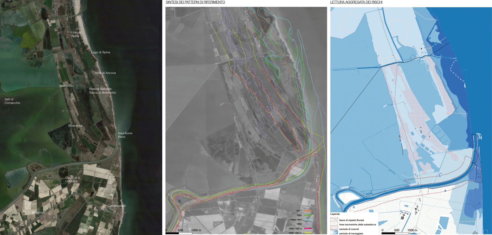
The Ravenna area is located in Emilia Romagna region, in Italy, overlooking the north-western coast of the upper Adriatic; like other coastal sectors of this geographical area, it is the result of a continuous process of adaptation and modification of its morphological and landscape structures (Amorosi et al., 2016; Antonellini et al., 2019). The displacement of the coastline, the variable path of rivers, the disappearance of wetlands, the construction of pine forests, are just some of the many dynamic processes that have shaped the current landscape (Fig. 1). The traces of this evolution are still clearly visible in many points of the territory (Simeoni, 2005). The ruins of the ancient Roman port of Classe, for example, testify to the presence of the sea in current agricultural and urbanized areas of the hinterland. The progressive advancement of the coastline has been accompanied, over the centuries, by massive hydraulic works that have led to the regimentation and diversion of rivers. Current wetlands and pine forests are the result of the mediation between such hydraulic works, the reclamation process to promote agriculture and the need to structure an intermediate landscape at the threshold of land and sea. Such evolution has been constantly monitored and determined by man following dynamic criteria. The advent of industrialization, with the development of new techniques for reclamation and water regulation, has resulted in a progressive crystallization of the landscape for the profitability of agriculture, port industry and touristic urban growth. What was previously an highly dynamic landscape, featured by instability and blurring ecosystems, underwent in a short time a very sharp compartmentalization accentuated by conservation and zoning policies (Antonellini & Mollema, 2010; Greggio et al., 2012). In this way, some ancient systems have been preserved, but have lost much of the resilience inherent in their being dynamic and transforming environments. A result of this process is clearly visible on the coast where the dune landscape has undergone increasing degradation. Anthropogenic aggression has relegated the dynamic ecosystem par-excellence to a very confined and too narrow space. The maintenance of the dunes has therefore become an exercise of naturalistic engineering without which they could hardly survive. Paradoxically, this tendency towards the stiffening of the territory is accelerating the transformation processes, making them more perceptible in the short term and less manageable. Face to climate change, this results in an effective increase of risk and vulnerability, in a greater exposure to extreme events and in a growing danger for the productive activities which have shaped this territory (Antonioli et al., 2017).
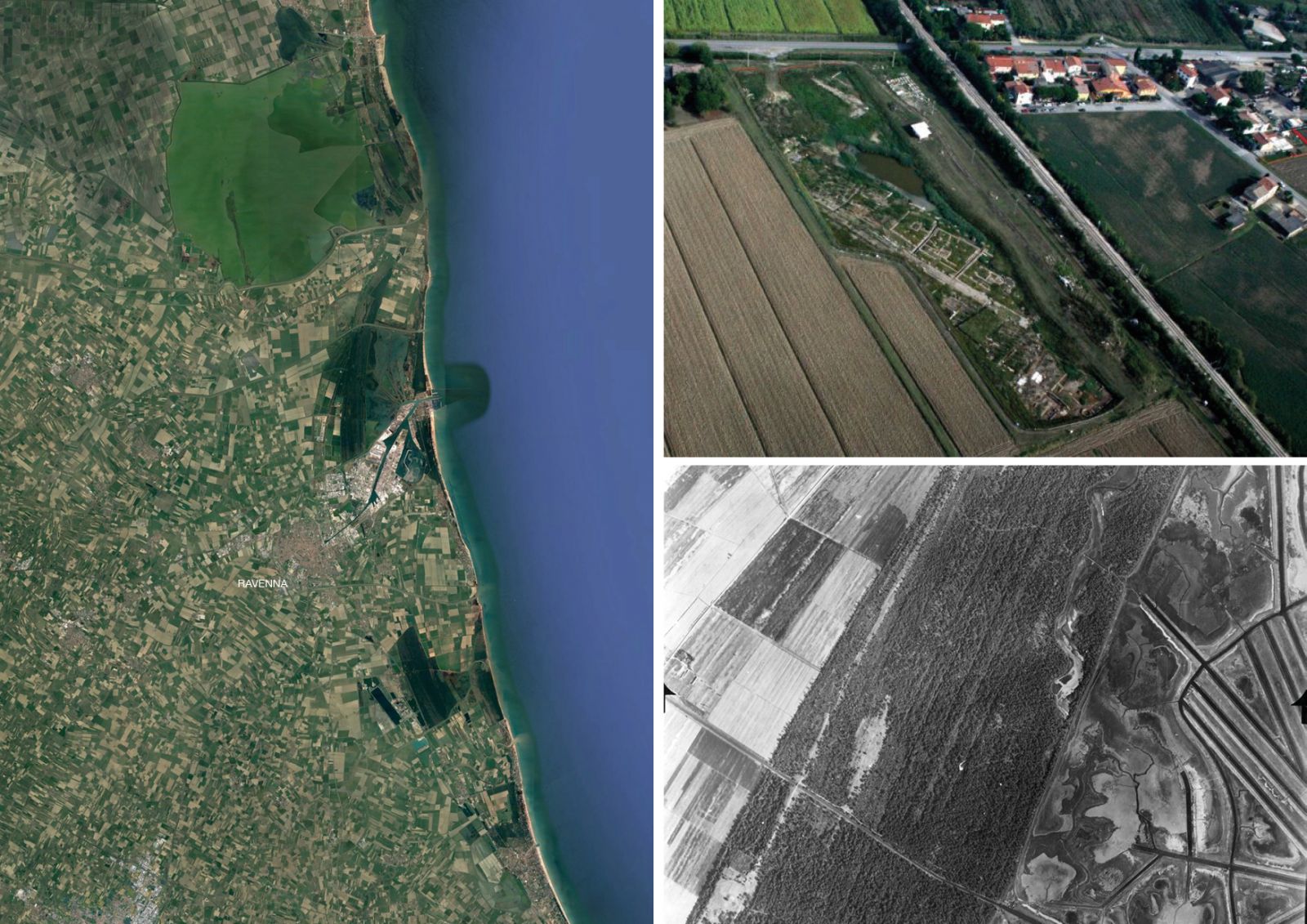
Source: Images from the author.
Fig. 1 On the left, a satellite imagery of the Ravenna area; upper right, the archeological site of Classe showing the ruins of the Roman harbour; lower right, an image showing the interface between agricultural areas and constructed wetlands.
The most recent and detailed climate forecasting models, analysing the combined action of subsidence and sea level rise on the coast of Emilia Romagna, depict an alarming picture at 2100. By this time, according to Perini et. al. (2017), in Ravenna, assuming the mid-sea relative rise of 57 cm predicted by the RCP8.5 scenario, 224 sq. km of territory will be sunken. Compared to the current 72 sq. km, there will be therefore a notable increase in risks for most of the coastal plain lands. Although most of them are not directly connected to the sea and therefore not necessarily affected by flooding, such condition will make drainage and hydraulic remediation increasingly complex and will boost the saline wedge intrusion in the rear-coast areas. The agricultural productivity of soils will suffer a drastic decline and the management of extreme climatic events linked to floods and storm surges will require the construction of exceptional defence works for protecting inhabited zones, tourist activities and naturalistic areas. In the next decades, the combined effects of subsidence and sea level rise - assuming the absence of human intervention - are expected to increase coastal instability, causing a further withdrawal of the shoreline that is estimated, depending on local conditions, in an interval between 500 m and 1 km.
A series of other risk factors connected to the availability of water resources and the effects of drought or overabundance of water on urban, agricultural and environmental systems will be added to this perspective (Bonnzi et al., 2010; Vandenbohede et al., 2014). They will manifest themselves in the variation of the seasonal distribution of temperature and rainfall, with an accentuation of intense events. According to the IPCC scenario RCP8.5, the number of days per year with very intense rainfall (20 mm or more) will increase by about 8 units. Likewise, periods of prolonged drought will increase from 40 to 60 consecutive days. The combination of these factors will cause desertification due to the higher evapotranspiration of the soil and will make fires more likely. In order to practice agriculture and other hydro-demanding activities, it will may be necessary to further draw on the resources of the underground aquifers with a consequent increase in subsidence. Similarly, the increasingly frequent occurrence of extraordinary events will act on the rivers' flooding with direct consequences on the infrastructural drainage system, currently not prepared to manage the large volumes of water to be expected during periods of exceptional rainfall.
3. Methodology: a scenario-based approach for landscape-oriented choices
Risk analysis and climate change projections are not sufficient to build a future reference scenario as they do not consider the adaptation actions that a territory can carry on to combat them. However, these actions are subject to multiple factors of uncertainty that depend on higher-level planning (national and European), on future socio-economic conditions, on the development of important infrastructural investments and, last but not least, on the cultural attitude towards environmental and ecological topics. One way to integrate these variables into a long-term strategic process is to apply the “scenario thinking” technique (Wack, 1985; Rounsevell & Metzger, 2010; Stürck, 2018; Lobosco, 2020a), and therefore building alternative future scenarios that can act as reference and horizon for the most imminent decisions. As landscape architects supporting planning, we are called to transpose these “narratives” into coherent landscape forms in which anthropogenic and environmental structures are transformed to achieve a credible ecological balance.
To do this, we have hypothesized two alternative strategic approaches to face climate change: a “rigid-conservative” one and “soft-evolutionary” one. They reflect two opposing, but both plausible, attitudes which in the long run could lead to completely different land-use arrangements and landscape management models.
The first alternative foreshadows a fully conservative approach for keeping the current configuration of the territorial context. This would entail a tendency to stiffen the landscape system on the present articulation of anthropogenic and environmental infrastructures that, on the other hand, in order to face climate change, must be strengthened to maintain as stable as possible current land-uses, functional destinations of the soil and their location on the territory.
The second alternative refers to a more dynamic and evolutionary vision of the landscape for which greater flexibility and "softness" of the infrastructural and ecological systems are assumed compared to the current configuration. According to this different attitude, the future layout of the territory could more freely follow the geomorphological characteristics of the soils and use them as a pattern for a different layout of anthropic activities and for the development of new resilient ecosystems.
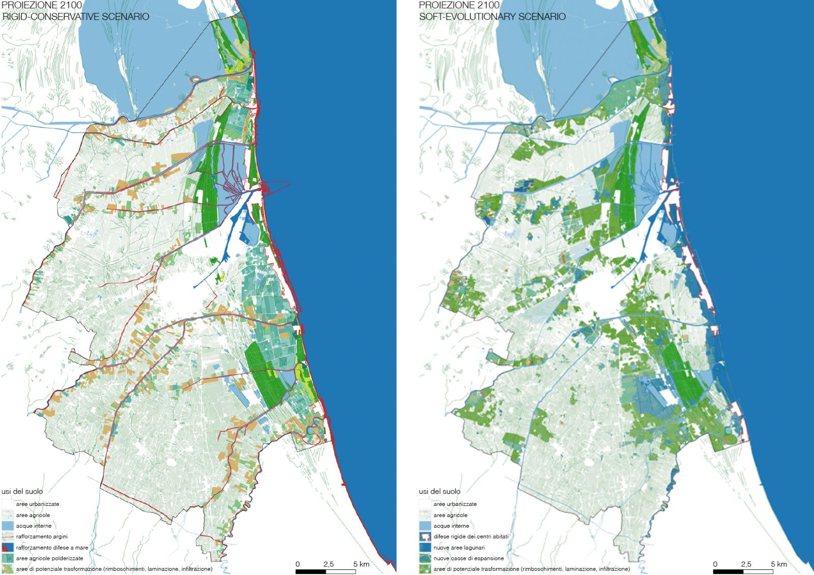
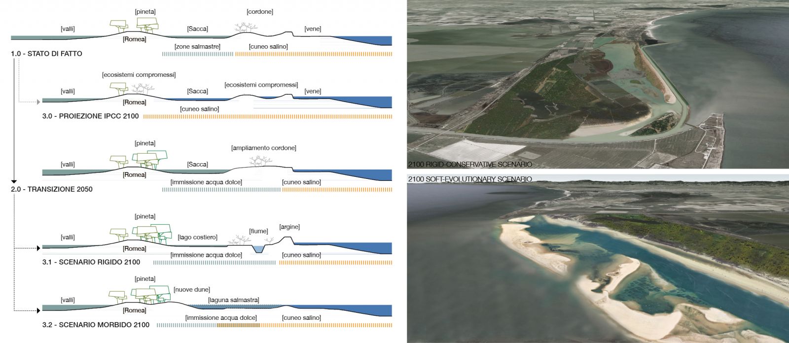
Starting from these two hypotheses, the corresponding future landscapes have been designed on a 2100 time horizon by interacting the data obtained from the RCP8.5 climate model (considering relative sea level rise of + 57cm) with the mapping of the associated risks and the anthropogenic and ecological infrastructures present in the area (Fig. 2). In order to build these scenarios on a territorial scale, we worked on the morphing of the Ravenna DTM (i.e. Digital Terrain Model) arranging the relative redistribution of environmental patterns according to future topographical and hydrographic conditions (Fig. 3). This made it possible to describe the two landscape scenarios both in qualitative and quantitative terms, to compare them and to evaluate ex-ante the extent of the transformations and investments they would require.
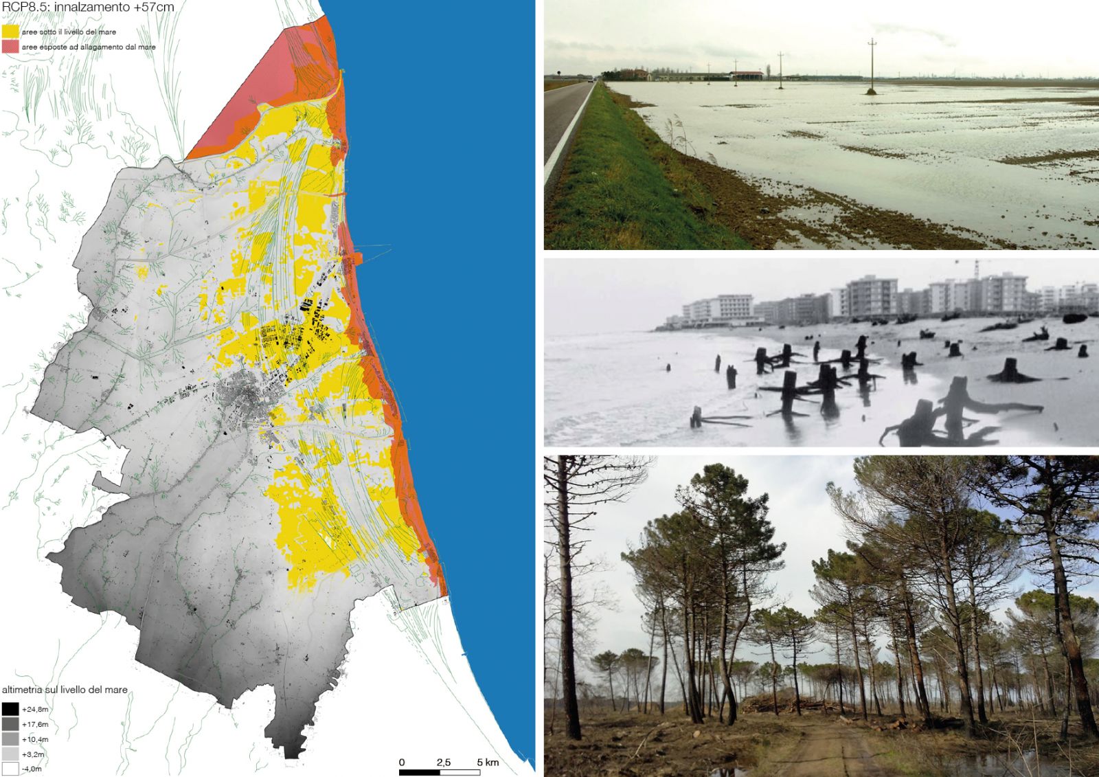
Source: Images from the author.
Fig. 2 On the left, the cartographic processing showing the aggregate effects of subsidence and sea level rise on the risk of flooding from the sea in the RCP8.5 scenarios to 2100. On the right, three example of the present effects of climate change on the territory.
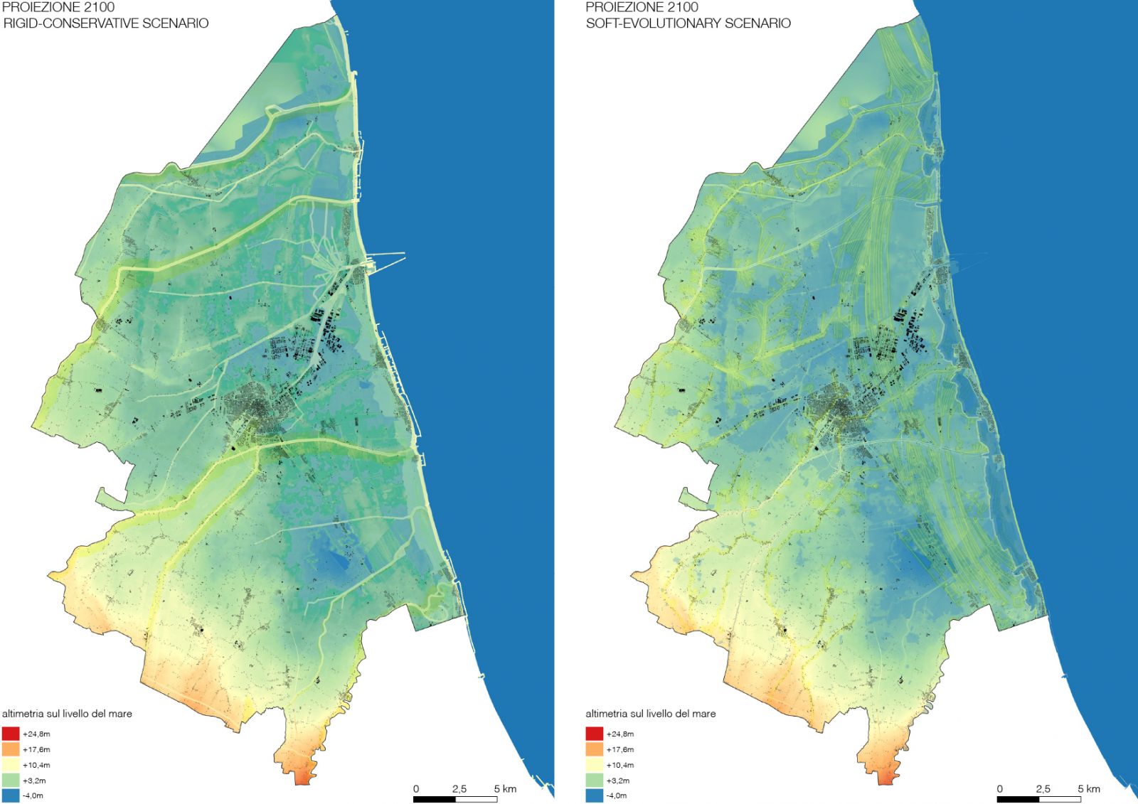
Source: Images from the author.
Fig. 3 The two hypothetical topographies corresponding to the alternative long-term scenarios.
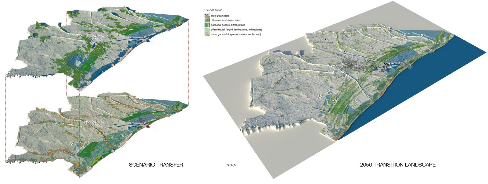
Beyond these preliminary assessments, from a methodological and strategic point of view, the two scenarios have not been considered as mutually exclusive, but have been used in the "scenario transfer" operation (Di Giulio et al., 2018; Emanueli & Lobosco, 2018), the aim of which is to define a 2050 transition landscape capable of evolve indifferently towards one of the two scenarios - “rigid” or “soft” - which both, in the long term, can ensure the safety and balance of the territory. From a technical point of view, this procedure consists in a GIS-based superimposition of the two 2100 DTM models and their related environmental patterns (Fig. 4); this allows to generate a synthetic cartography that can be analysed through geo-processing operations evaluating the reciprocal deviation rate of the spatial attributes inherited from the two starting scenarios. The areas associated with lowest deviation values represent a sort of matrix shared by the two future landscapes that we take consequently as the territorial “palimpsest” on which to immediately undertake adaptation actions and build a vision for 2050.
This procedure was applied on a municipal scale and subsequently tested in specific case studies exemplifying the risk conditions recurring in the area.
4. Results
This section presents the research results obtained by applying the previously described methodology. The first paragraph focuses on the construction of possible alternative long-term scenarios for adaptation to climate change (2100) from which a 2050 strategic vision for the entire municipal area has been obtained. The second paragraph presents in-depth the two applicative case studies developed on different contexts of the Ravenna coastal landscape.
4.1. From 2100 scenarios back to 2050 strategic vision
The construction of long-term scenarios, as mentioned, presupposes the development of a “credible narrative” based on quantifiable data declined according to a hypothetical development trajectory of the territory. This trends depends on extremely uncertain forces and variables, largely independent from local orientations and, especially in a context such as the Italian one, complicated by the stratification and overlapping of competences assigned to the various governance and management bodies of the territory. In such a context, the key element affecting strategic policies for the future - we believe - lies in the dominant cultural attitude at the basis of our idea of landscape. Without expressing a preventive judgment on the matter, we have examined two opposing orientations - “conservative” and “evolutive” - trying to prefigure which kind of territorial structure they can lead to, assuming their equal effectiveness in relation to the climate change. This “attitude” idea, which may seem an extremely generic abstraction, actually has a strong impact on the regulatory systems (at national and supranational level) in whose framework tangible adaptation actions must be developed.
In an area such Ravenna, for example, where a large part of the territory is subject to historical and environmental restrictions or where most of the coastal ecosystems now degraded (and in constant danger) are part of regulated protected areas, a more or less conservative approach on preservation policies implies in perspective completely different results regarding the shape of the landscape. Extremely, we are faced with the following question: do I defend an existing habitat, “how is it where it is”, altering everything around it? Or, do I accept that it changes favouring also the conditions so that it can move elsewhere?
The construction of the long-term scenarios is not intended to provide a straight answer to this question; instead, it seeks to inform decision-makers on two fundamental aspects: the consistency and qualities of landscapes that can arise from one choice rather than another (Fig. 5); the strategic interventions that can be planned over a shorter time horizon so that the safety of the territory is guaranteed and the possibility of moving towards one of the two scenarios remains open.
In our proposal, the "rigid-conservative" scenario describes a strategic attitude that aims to keep the landscape as unchanged as possible even in the face of climate change. This objective can be pursued by concentrating the adaptation actions in proximity of existing defence systems located at the interface between the different environments and ecosystems. This will lead to the strengthening and increase of sea barriers, river banks and the enhancement of the mechanical drainage system for reclamation management. These interventions will act directly and significantly on the topography of the area. The hydraulic section of the rivers will have to be increased and integrated with storage areas adjacent to them. Along the coastline it will be necessary to develop a defence system - against storm surges and the saline wedge - consisting of dams and a network of channels interspersed with artificially drained areas following to the classic “polder scheme”. The priority of defending inhabited and productive areas from river floods requires to develop new embankments and retention basins along its buffer zones. The rear coastal areas, protected by the artificial elevation of the coastal strip, in order to preserve their agricultural function, will also need a water channel system capable of bringing fresh water against the saline wedge intrusion and, at the same time, useful for draining the more sunken areas by means of waters pumps. The extension of such mechanical water handling systems will result in a significant increase in energy requirements and emissions. Productive sectors such as the beach tourism, so important for the territory, will need to re-invent themselves facing the new costal landscape.
Source: Images from the author.
Fig. 5 The cartographies represent the two alternative long-term scenarios and the related environmental patterns.
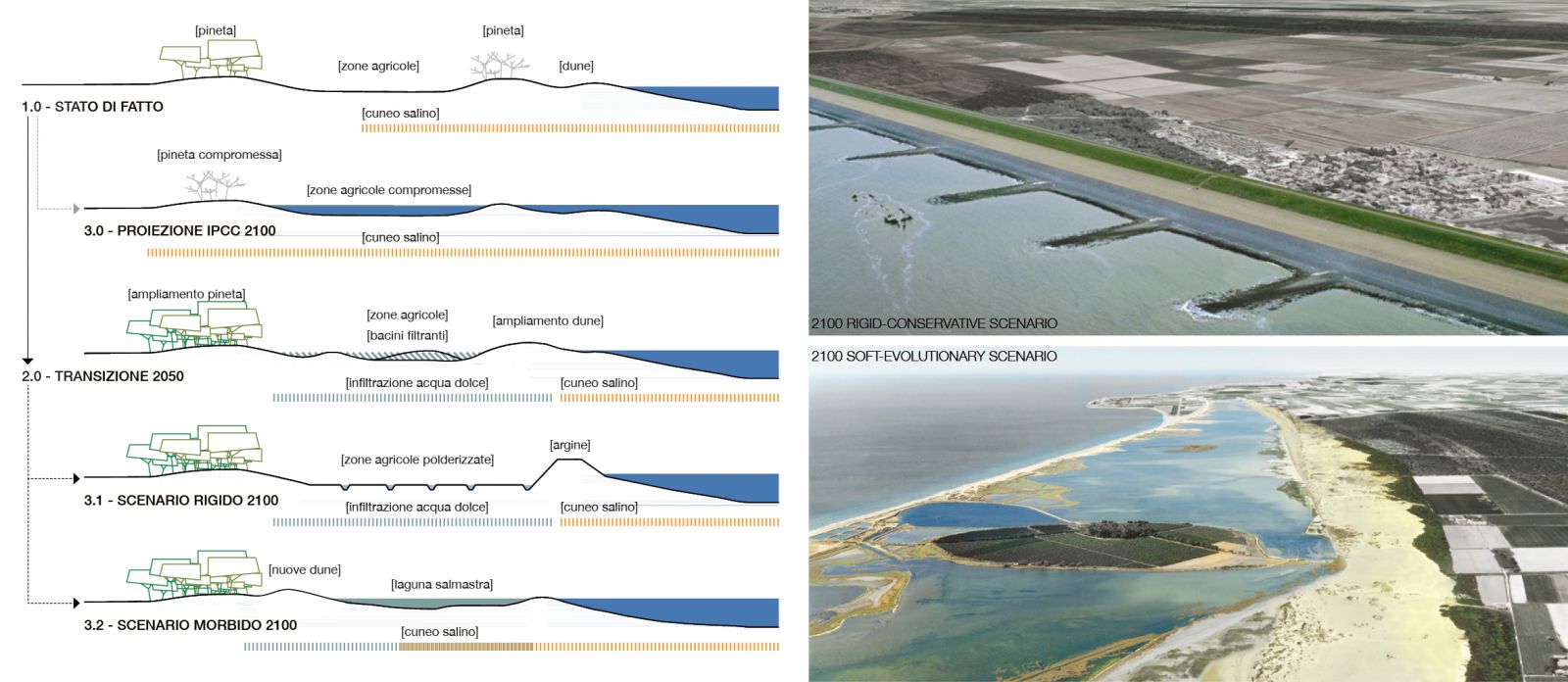
On the other hand, the "soft-evolutionary" scenario summarizes a much more dynamic approach to climate change adaption. In this perspective, the transformations of the landscape are functional to establish a new balance between anthropic and environmental systems without conservative limitations. The hypothesized structure is based on the selection of areas with the greatest potential criticality in terms of flooding, salinization and subsidence; these, depending on their location, are used as controlled retreat areas from the sea or are transformed into extensive wetlands and forests. Through these operations, the resilience to environmental risks is achieved by relying on the historical geomorphology of the landscape, minimizing the intervention on anthropogenic defence infrastructures. The protection of settlements exposed to storm surges or floods is achieved through the development of "buffer zones" capable of absorbing their impact by functioning as transition ecosystems between urbanized and rural areas. Depending on the composition of the soils and on the topography, these areas will assume different function such as infiltration and recharge of the underground aquifers, or coastal lakes and retention basins. The selective retreat from the sea will make room for proper-wide dune systems and plain woods replacing those coastal habitats (such as pine forests) currently in crisis. The energy consumption related to the water management of this system will probably be lower than the current one. Many productive activity such as agriculture and touristic resort will need to be moved and re-arranged along the new coastline.
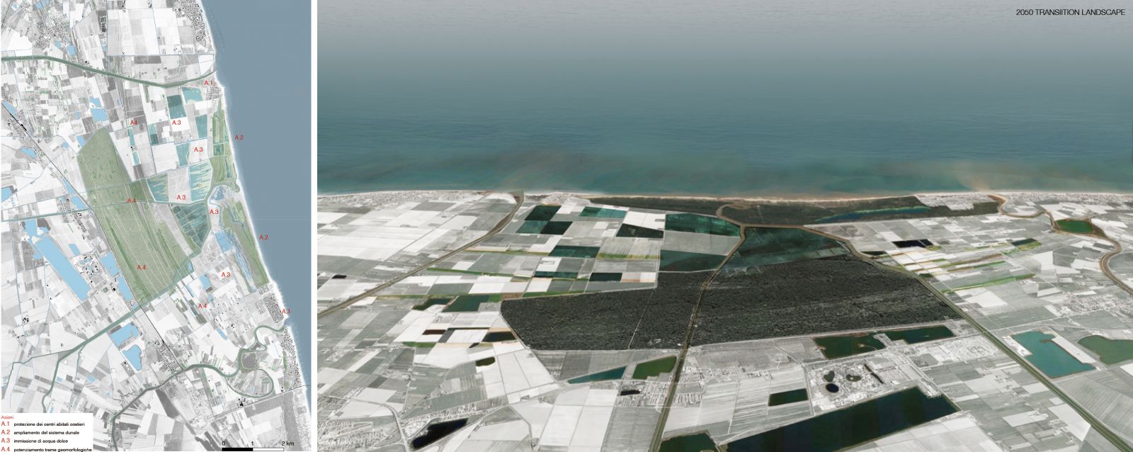
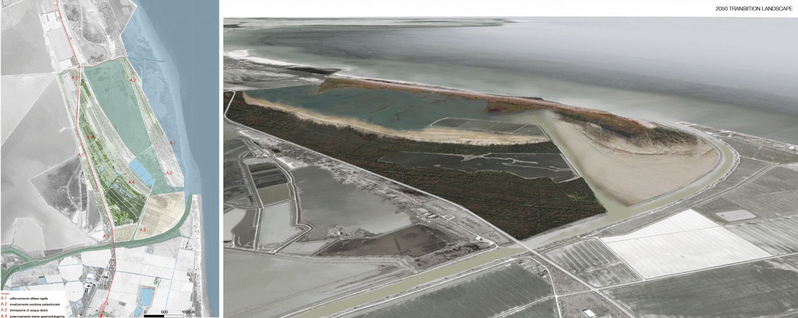
If the conceptual assumption is that both long-term scenarios have equal "dignity" and the same possibility of being realized, the strategic vision in the short-medium term, to be truly resilient, must provide for different degrees of freedom: in essence, it must represent a “transition landscape” between the current territorial structure - of which we have certainties and information - and the future one - with respect to which we advance hypotheses and forecasts. Following this reasoning, we can affirm that the 2050 landscape is configured as an intermediate scenario, capable of acting on the reduction of risks and, at the same time, preparing the field for further adaptations. In concrete terms, this approach has been carried out in the Ravenna area by developing two main landscape systems that we could define as "actively defensive" for their aim to protect the territory grounding a new geography (Fig. 6).

Source: Images from the author.
Fig. 6 The chart shows the 2050 transition landscape layout with the localisation and the aerial views of the case-studies' areas presented in the article.
The first one corresponds to the more advanced coastal strip collecting those areas now directly affected by the sea level rise and the saline wedge intrusion. Here the primary need is to strengthen the dune systems and bring fresh water close to the coast in order to stop the desertification of the soils and the degradation of the habitats. This solution, in perspective, is functional both to the formation of the lagoon systems predicted by the "soft" scenario and to the polderization hypothesized in the "rigid" one. The second defensive device, further back, rests on the topography, articulating itself partly along the existing water network and partly along the traces of the ancient coastal strips or dismissed river beds. The resulting pattern is where the works of water retention, lamination and infiltration will possibly be further implemented alternative following the rivers' buffer zones (according to the rigid scenario) or converting the most sunken and less productive agricultural areas (according the soft scenario).
The applicative case studies, which follow, aim to transfer and verify on more limited areas the logical steps set out so far on a municipal scale. We will focus on two areas particularly exposed to the effects of sea level rise: the coastal strip between the “Lido di Dante” and the “Lido di Classe”; and the left side of the current mouth of the Reno river up to the municipal limit with Comacchio. They are two areas of great naturalistic and environmental value whose habitats and activities related to tourism and agriculture are strongly threatened. The two landscape transformation projects, as we will see, even though sharing a common overall strategy, examine in depth different short-term actions that give an idea of the complexity featuring the whole territory.
4.2. Case-study 1: action plan for a coastal productive area
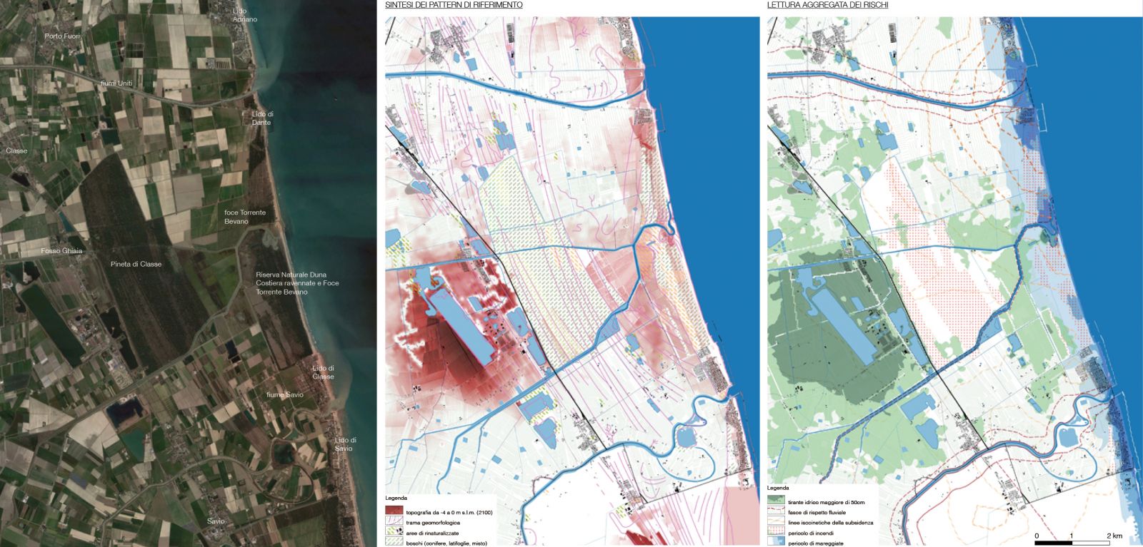
The study area, between the Lido di Dante and the Lido di Classe, extends from the coast to the hinterland up to the Pineta di Classe Naturalistic Reserve. The main hydrographic network is characterized by the presence of the so-called United Rivers to the north, further south the Bevano RIver and then the Savio River. In this zone, several important ecosystems of recognized landscape and environmental value (the pine forests, the Ravenna Coastal Dune Reserve and the Bevano River Mouth, the Ortazzo valleys) alternate with agricultural areas largely below sea level. The area is currently undergoing a series of alterations that are seriously compromising the ecosystems health - such as the coastal pine forest - and the survival of important economic activities such as tourism and agriculture. The effects of storm surges and sea level rise cause in this extremely sunked area a strong salinization of the soils accentuated by the subsidence. In the absence of targeted interventions, also existing settlement will be increasingly exposed to floods and fires that already occur recurrently in the pine forests (Fig. 7).
Faced with these problems, it could be strategically possible to maintain the coastline in its current position and keep areas behind it mainly aimed at agriculture. This assumption describing the “rigid-conservative” scenario at 2100 would involve the need to develop a land management system very similar to the one applied on polderized areas of northern Europe. The main elements that compose it are summarized in figure 8 representing a landscape completely protected from the sea by means of a defensive breakwater infrastructure. Towards the hinterland it will be necessary to provide an articulated water movement system calibrated on the dual need to drain the crops and, in any case, ensure the presence of fresh water to counteract the saline wedge especially in the lower areas adjacent to the sea barrier.
On the contrary, the "soft-evolutionary” scenario involve the decision to absorb the impact of sea level rise by adopting a more selective strategy: by fully protecting only the inhabited centres on the coast and planning a controlled retreat of the coastal line according to a different scheme of land use. The landscape resulting from this scenario (Fig. 8) is characterized by a brackish lagoon developed in the lower areas between the current shoreline and the new dune system that will grow in the areas facing the “Classe Pineta” in correspondence with the existing paleodunal cordons. The efficiency of this structure, with respect to future weather and sea conditions, will lie on a dynamic balance between erosion and accumulation of sediments guaranteed by the width of the newly formed dune belt whose backward positioning assures a significantly higher altitudes with respect to the middle sea one.
Comparing the two 2100 alternative scenarios, it is possible to identify some common preparatory actions that can be credibly developed over the next 30 years to counteract the climatic trends already underway and prepare the territory for subsequent adaptations (Fig. 9). These interventions' location is based on the geomorphological features of the area and on the analysis of the agricultural soils composition which gives us back their current productivity. The main actions defining the proposed adaptation strategy by 2050, their impact on risk factors and their subsequent dynamics of transformation towards one of the two long-term scenarios are presented below.
Action 1 concerns the protection of the inhabited areas from rivers' flooding and storm surges. With this aim, it will be necessary to progressively develop around them a new topography capable of effectively work as a barrier against the most extreme events, valid for both scenarios in the long term.
Source: Images from the author.
Fig. 7 Case-study 1, from the left: the current state of the area; a synthetic representation of the geomorphological patterns across it; and the aggregated cartography of the main risks.
Source: Images from the author.
Fig. 8 Case-study 1: on the left, a diagrammatic representation of the steps composing the adaptation strategy on the area; on the right, the two long-term reference scenarios.
Source: Images from the author.
Fig. 9 Case-study 1: the adaption masterplan for the area (in red are pinpointed the four main actions) and the corresponding bird-eye view showing the 2050 transition landscape.
Action 2 focuses on the integrated management of the coastal strip between the two inhabited settlements by strengthening the ongoing interventions on the dune system. The goal is to provide more resilient protection to storm surges and to counteract saline intrusion through the system's inherent ability to promote the formation of freshwater lenses beneath it. To effectively reactivate these dynamics, it is necessary to increase the thickness of the dunes to the detriment of the coastal pine forest, especially where it is most degraded therefore more exposed to fire. The sediment stock deriving from the dunes strengthening will be able to ground a further artificial raising of the barrier to the sea, “in the rigid scenario”, or it will allow to nourish the more rearward beaches in the hypothesis of the coastline retreat envisaged by the “soft scenario”.
Action 3 concerns the establishment of a buffer zone between the Classe Pineta and the coastal strip where to develop, more or less temporary, fresh-water reservoirs between the crop fields consisting of wetlands, coastal lakes and infiltration areas. Their purpose is to act as a barrier to saline intrusion and as retention areas against the risk of floods, improving, at the same time, the soil productivity and the water quality of the artesian aquifer. The formation process of this new landscape is based on the filling up mechanism historically used to reclaim sunken areas: thanks to the deposit of solid material brought into suspension by the water, vast areas can be progressively fed and risen in altitude. Then, the excess water is channeled towards to the surrounding areas that are meant to be permanently flooded. The latter, depending on soil permeability, may evolve towards different ecosystems such as swamps, plain forests or productive areas related for example to fish farming. Subsequently, depending on the strategic direction chosen, these flooded areas will constitute the first points of development of the brackish lagoon system (in the soft scenario), or can be drained and restored to agricultural function (in the rigid scenario) with more effective results given the higher relative altitude they reached for the previous the sediment accumulation.
Lastly, Action 4 aims to consolidate and restore the main geomorphological structures of the area by focusing on the traces of the ancient coastlines and paleodunes that underlie the Pinewood of Classe and other areas currently occupied by agriculture. A new large-scale green infrastructure can be set up through the development of less erosive farming practices, topographical recomposition interventions and targeted forestation. In addition to function as an ecological corridor and biodiversity reserve, it sets the stage for implementing a second defence line more internal to the coast. In both 2100 scenarios, this action will help improving the area's water invariance and counteracting desertification phenomena.
4.3. Case-study 2: action plan for an environmental protected area
The project area is located on the northern border of the municipality and it extends from the mouth of the Reno River to the Spina Lake, between the Comacchio Valleys and the sea. The site has a high environmental diversity organized, starting from the Romea Roadway, according the footprints of the ancient coastlines - on which lie pine forests, plain woods and cultivated fields - interspersed with vast brackish depressions, valleys and wetlands. The current coastal strip is characterized by the marsh called Ancona Veins which is part of the Bellocchio ZCS-ZPS Naturalistic Reserve. The area is strongly affected by storm surges and coastal erosion, accelerated by the progressive sea level rise and by the considerable decrease in the sediments supply from the Reno river. Since the Ancona Veins are almost disappearing, the settlement of the coast can be placed in correspondence with the rigid defence structure built to the east of the paleodunal cordon that divides them from the “Sacca di Bellocchio”. This condition amplifies the intrusion of the saline wedge, affecting the biotic balance of wetlands and brackish waters where fish farming is still practiced. In the same way, the ecosystems underlying the pine forests and plain woods that largely cover the emerged parts are increasingly at risk (Fig. 10).
The development of a "rigid scenario", aimed at keeping the current coastline almost unchanged while preserving the ecological characteristics of the Sacca di Bellocchio (Fig. 11), would require the raising of a coastal defence capable of stopping the storm surges. In addition to this device, a series of interventions are needed in order to avoid the degradation of coastal habitats keeping a proper balance of water sanility. These instances have been summarized in a future landscape restoring the layout of Reno river as it was until the 1950s: with its mouth further north, just below the Spina Lake. By diverting the river course, its new river embankments become a barrier to the rising of the sea and exceptional events; moreover, the riverbed itself con contrast with fresh water percolation in the soil the salt intrusion in the back wetlands. Here, the salinization issue is further mitigated by the creation of a river bypass which allows controlled flooding and therefore the introduction of fresh water as needed in the Sacca di Bellocchio.
Source: Images from the author.
Fig. 10 Case-study 2, from the left: the current state of the area; a synthetic representation of the geomorphological patterns across it; and the aggregated cartography of the main risks.
Source: Images from the author.
Fig. 11 Case-study 2: on the left, a diagrammatic representation of the steps composing the adaptation strategy on the area; on the right, the two long-term reference scenarios.
The “soft scenario” construction takes into account the same data and forecasts used in the previous case, but projecting them on a diametrically opposite choice, hypothetically informed by a different attitude towards the protection of naturalistic areas (Fig. 11). In fact, the ecosystems and habitats that currently exist on the area would be progressively set back following the evolution of the coastline with respect to the mid-sea level. In this scenario, the transformation process of the landscape is triggered by the abandonment and dismantling of the most advanced rigid defences, at the Veins of Bellocchio and Ancona. This operation involves a gradual erosion of the first coastal strip which, free from the embankments behind it, works a reserve of material for the constitution of a more backward lagoon system. This stock is meant to nourish the new beaches and dune system in adherence to the pine forest crossed by the Romea Roadway. In this configuration, the new Reno River's mouth, considerably more backward, would contribute to balancing the lagoon salinity and would allow to recreate in a new sector of the territory the brackish habitats that have disappeared.
In this case study too, the two 2100 scenarios inform the definition of the 2050 adaptation strategy which, in the medium term, aims at maintaining those biodiversity and environmental conditions favourable to the peculiar fauna and vegetation of the area. This intermediate configuration (Fig. 12) must be able to evolve indifferently towards one of the two scenarios which, in the long term, ensure the survival of the naturalistic area in environmental and climatic conditions that are very different from the current ones. Some of the specific actions to be implemented in the next 30 years follow the general concepts presented in the previous case study, but declined according to the particular geomorphological characteristics of this area.
Action 1 concerns the structural updating of the rigid coastal defences: the raising of the existing embankment behind the Ancona Veins will be commensurate with the rising sea level and the risk of intense floods; then it is extremely important to raise the altitude of the Romea Roadway in order to set up a second barrier against extreme events. Both interventions are aimed at preparing the development of a more effective defence system according to the provisions of the two alternative 2100 scenarios.
Action 2 focuses on the integrated management of the coastal dune belt between the most advanced embankment and the Sacca di Bellocchio. In this area, which currently hosts a strongly compromised pine forest, the intervention aims at increasing both the extension and the elevation of the drylands. This operation involves replacing the pine forest with new artificial dunes in the most degraded areas. The immediate goal is to provide more resilient protection to storm surges and to counteract saline intrusion through the intrinsic ability of the dune systems to favour the accumulation of underground freshwater. By 2100, this land reserve could be used alternatively for the construction of the left bank of the “new and prolonged” Reno River (in the rigid scenario) or as a sediment stock for nourishing the internal beaches of the brackish lagoon (in the soft scenario).
Action 3 involves the strengthening of the direct hydraulic connection between the Sacca di Bellocchio and the Reno river. The mouth of the river is split following the traces of the ancient riverbed in order to create a bypass capable of supplying the Sacca with fresh water and sediment. This operation allows to counteract the salinization of the area and regulate more effectively the periodic river's floods by exploiting it as a retention basin. The sediment flowing into the Sacca by this mens also contibute to elevate the topography nearby the defence lines which will be subsequently alternately developed depending on the chosen long-term scenario.
Finally, Action 4 proposes also in this area to develop less erosive agricultural practices, topographic recomposition interventions and targeted forestation among the paleodunes that underlie the area between the Sacca di Bellocchio and the Romea Roadway. The goal is to set up a second line of defence valid in both 2100 scenarios in order to protect the Comacchio Valleys, one of the hotspots of UNESCO Po Delta Natural Park.
5. Conclusions
The methodology and the research results presented in this article are the arise from an intense multidisciplinary work based on the collaboration with the Municipality and the several subjects involved into the development and management of territorial infrastructures. Reclamation consortia, public authorities and private companies - managing water, communication and energy infrastructures, just to name just a few - represent a fundamental component for the success of the adaptation process to climate change. Their ability to affect the real shape of the territory, and to monitor its transformations, is an opportunity to be seized and enhanced so that the whole strategic vision is grounded on pragmatic expectations. In such perspective, the PAESC can represent the basis on which to strengthen this collaboration and build a shared vision for the future. As part of this research, efforts have been made to trigger this mechanism to outline a strategy capable of responding to risks and leaving open the possibility of an evolution of the territory towards the two long-term scenarios identified. The main objective was to provide the Administration with a tool to support strategic choices that can be implemented in the future through further investigations and the development of further cases. In the same way, the result of the research can be understood as the reference for a discussion platform between the Municipality, local actors and citizens. A device for communicating the scale of the challenges that Ravenna, like many other cities, is called upon to respond to and provide its contribution so that environmental issues remain at the centre of the political and cultural agenda.
In this perspective, we believe the role of landscape design can be central for at least two reasons. The first one concerns the need for an accurate quantitative and qualitative representation of the climate change effects and especially of the options we have to adapt the territory to. Data and models provided by the engineering sciences, however fundamental, hardly can give a clear and understandable idea of the transformations taking place on a "human scale". Similarly, very often they do not contemplate the anthropogenic variables that can affect the analysed trends. This gap may remove from the decision makers' perception the genuine need to build a future-oriented vision for the territory rooted more on expectations than on problems.
This distinction, which is absolutely anti-rhetorical, underlies the second reason why we consider landscape architecture so important in this process. To build a balanced and consistent territorial vision, it is necessary to read and interpret the historical dynamics of landscape transformation and to recognize those relationships of necessity between man and the environment that have deeply determined its evolution. Ravenna is a striking example of how these processes could be articulated in an infinite series of places, ecosystems and landscapes. It is a territory largely shaped by a community who has adapted it to its own needs, aspirations and imaginative tensions. A territory that wonders today how to face an unavoidable change while maintaining that same creative and pragmatic outlook that has moved rivers, built beaches and forests, that has torn productive land from the sea; in brief, a territory that has always been able to react, adapt and manipulate its future.
On these assumptions, it is possible to effectively transpose the global dimension of a phenomenon such as the Climate Change into a local scale (Lobosco, 2020b) avoiding - as we have tried to demonstrate through the research - to restrict the concept of resilience into standardized devices or handbook practices, too marginal if compared to extent of the problems and somehow quite sterile in terms of strategic vision. Ultimately, the reasoning on future scenarios can help to broaden the horizon of choices through an imaginative effort that seeks to bring few questions back to attention of decision-makers, stakeholders and communities: towards what kind of landscape we want to go? and how?

