<?xml version="1.0" encoding="ISO-8859-1"?><article xmlns:mml="http://www.w3.org/1998/Math/MathML" xmlns:xlink="http://www.w3.org/1999/xlink" xmlns:xsi="http://www.w3.org/2001/XMLSchema-instance">
<front>
<journal-meta>
<journal-id>0430-5027</journal-id>
<journal-title><![CDATA[Finisterra - Revista Portuguesa de Geografia]]></journal-title>
<abbrev-journal-title><![CDATA[Finisterra]]></abbrev-journal-title>
<issn>0430-5027</issn>
<publisher>
<publisher-name><![CDATA[Centro de Estudos Geográficos]]></publisher-name>
</publisher>
</journal-meta>
<article-meta>
<article-id>S0430-50272014000200006</article-id>
<title-group>
<article-title xml:lang="en"><![CDATA[Lisbon heat island statistical study (2004-2012)]]></article-title>
<article-title xml:lang="pt"><![CDATA[A ilha de calor em Lisboa. Estudo estatístico (2004-2012)]]></article-title>
</title-group>
<contrib-group>
<contrib contrib-type="author">
<name>
<surname><![CDATA[Alcoforado]]></surname>
<given-names><![CDATA[Maria João]]></given-names>
</name>
<xref ref-type="aff" rid="A01"/>
</contrib>
<contrib contrib-type="author">
<name>
<surname><![CDATA[Lopes]]></surname>
<given-names><![CDATA[António]]></given-names>
</name>
<xref ref-type="aff" rid="A01"/>
</contrib>
<contrib contrib-type="author">
<name>
<surname><![CDATA[Alves]]></surname>
<given-names><![CDATA[Elis Dener Lima]]></given-names>
</name>
<xref ref-type="aff" rid="A02"/>
</contrib>
<contrib contrib-type="author">
<name>
<surname><![CDATA[Canário]]></surname>
<given-names><![CDATA[Paulo]]></given-names>
</name>
<xref ref-type="aff" rid="A01"/>
</contrib>
</contrib-group>
<aff id="A01">
<institution><![CDATA[,Universidade de Lisboa Instituto de Geografia e Ordenamento do Território Centro de Estudos Geográficos]]></institution>
<addr-line><![CDATA[Lisboa ]]></addr-line>
<country>Portugal</country>
</aff>
<aff id="A02">
<institution><![CDATA[,University of São Paulo São Carlos school of Engineering ]]></institution>
<addr-line><![CDATA[São Paulo ]]></addr-line>
<country>Brazil</country>
</aff>
<pub-date pub-type="pub">
<day>00</day>
<month>12</month>
<year>2014</year>
</pub-date>
<pub-date pub-type="epub">
<day>00</day>
<month>12</month>
<year>2014</year>
</pub-date>
<numero>98</numero>
<fpage>61</fpage>
<lpage>80</lpage>
<copyright-statement/>
<copyright-year/>
<self-uri xlink:href="http://scielo.pt/scielo.php?script=sci_arttext&amp;pid=S0430-50272014000200006&amp;lng=en&amp;nrm=iso"></self-uri><self-uri xlink:href="http://scielo.pt/scielo.php?script=sci_abstract&amp;pid=S0430-50272014000200006&amp;lng=en&amp;nrm=iso"></self-uri><self-uri xlink:href="http://scielo.pt/scielo.php?script=sci_pdf&amp;pid=S0430-50272014000200006&amp;lng=en&amp;nrm=iso"></self-uri><abstract abstract-type="short" xml:lang="en"><p><![CDATA[With the aim of implementing climatic guidelines for planning purposes, the urban climate of each particular city must be assessed, particularly the frequency of unwanted climatic features, such as the Urban Heat island (UHI). As the Lisbon &#8220;Mesoscale urban meteorological network&#8221; (CEG-IGOT-ULisboa) has been running since 2004, it is now possible to present statistical results about the UHI. It was calculated on an hourly basis as the difference between one of the &#8220;central&#8221; measurement points (Restauradores or Saldanha) and one of the eccentric points of the network (Carnide or Monsanto). UHI is more intense in summer (maximum hourly averages up to 6.3ºC) than in winter (up to 3.8ºC), and more intense during the night than during the day. in Lisbon, its causes are not only due to the modification of energy balance in urban areas, but also to the shelter effect from the prevailing and cold/cool north winds, due to the topography and the buildings.]]></p></abstract>
<abstract abstract-type="short" xml:lang="pt"><p><![CDATA[Para informar as decisões sobre orientações climáticas para o ordenamento do território, é necessário conhecer o clima urbano de cada cidade, nomeadamente no que diz respeito à frequência de ocorrência de fenómenos considerados indesejáveis, como a ilha de calor (IC) urbana. Depois de 8 anos de funcionamento da &#8220;rede de mesoscala&#8221; de monitorização meteorológica em Lisboa (CEG-IGOT-ULisboa), é agora possível apresentar resultados estatísticos sobre a IC. é explicada metodologia de cálculo da intensidade da ilha de calor, pela diferença entre um dos postos &#8220;centrais&#8221; (Restauradores ou Saldanha) e um dos postos mais excêntricos (Carnide ou Monsanto). A IC é mais intensa e frequente no Verão (valor máximo horário: 6,3ºC) do que no inverno (valor máximo: 3,8ºC) e é mais intensa de noite do que de dia. Em Lisboa, as causas da IC devem-se não só à modificação de parâmetros do balanço energético em meio urbano, como também ao efeito de abrigo de ventos dominantes frios ou frescos do quadrante norte, proporcionado pela topografia e pelos próprios edifícios.]]></p></abstract>
<abstract abstract-type="short" xml:lang="fr"><p><![CDATA[Etude statistique del'îlot de chaleur à Lisbonne. La connaissance des climats urbains est nécessaire à une juste appréciation des décisions à prendre dans le cadre de l'aménagement du territoire, et surtout en ce qui concerne la fréquence des phénomènes dits indésirables, comme l'îlot de chaleur urbain (IC). Un réseau «d 'échelle moyenne» d'observations météorologiques ayant fonctionné à Lisbonne de 2004 à 2012 (CEG-IGOT-ULisboa), on peut déjà présenter des résultats statistiques concernant l'IC. Le calcul de son intensité est basé sur la différence entre les données d'un poste «central» (Restauradores ou Saldanha) et celles d'un des postes les plus excentriques (Carnide ou Monsanto). L'îlot de chaleur est plus intense et plus fréquent en été (valeur maximale horaire de 6,3ºC), qu'en hiver (valeur maximale de 3,8ºC) et il est plus fort la nuit que le jour. À Lisbonne, les causes de l 'IC sont dues non seulement aux modifications des paramètres de bilan énergétique liées au milieu urbain, mais encore à un effet d'abri (des très fréquents vents frais ou froids de secteur nord) qui résulte de la topographie et des constructions.]]></p></abstract>
<kwd-group>
<kwd lng="en"><![CDATA[Urban Heat island (UHI)]]></kwd>
<kwd lng="en"><![CDATA[thermal patterns]]></kwd>
<kwd lng="en"><![CDATA[mesoclimatic network]]></kwd>
<kwd lng="en"><![CDATA[Lisbon]]></kwd>
<kwd lng="en"><![CDATA[Portugal]]></kwd>
<kwd lng="pt"><![CDATA[Ilha urbana de calor]]></kwd>
<kwd lng="pt"><![CDATA[padrões térmicos]]></kwd>
<kwd lng="pt"><![CDATA[rede mesoclimática]]></kwd>
<kwd lng="pt"><![CDATA[Lisboa]]></kwd>
<kwd lng="pt"><![CDATA[Portugal]]></kwd>
<kwd lng="fr"><![CDATA[Îlot de chaleur urbain]]></kwd>
<kwd lng="fr"><![CDATA[champs thermiques]]></kwd>
<kwd lng="fr"><![CDATA[réseau mésoclimatique]]></kwd>
<kwd lng="fr"><![CDATA[Lisbonne]]></kwd>
<kwd lng="fr"><![CDATA[Portugal]]></kwd>
</kwd-group>
</article-meta>
</front><body><![CDATA[ <div>       <p align="right"><b>ARTIGO ORIGINAL</b></p>    <br>      <p>&nbsp;</p>       <p><b>Lisbon heat island statistical study (2004-2012) </b>       <p>&nbsp;</p>       <p><b>A ilha de calor em Lisboa. Estudo estatístico (2004-2012)</b>       <p>&nbsp;</p>       <p>&nbsp;</p>       <p><b>Maria João Alcoforado<sup>1</sup>António Lopes<sup>2</sup>Elis Dener Lima Alves     <sup>3 </sup>Paulo Canário<sup>4</sup></b></p>       ]]></body>
<body><![CDATA[<p><sup>1</sup> Researcher at  CEG-IGOT-ULisboa, research Group ZePHyrUs, editor of Finisterra. Universidade de Lisboa, edifício da faculdade de Letras, alameda da Universidade,  1600-214 Lisboa, Portugal. E-mail: <a href="mailto:mjalcoforado@campus.ul.pt">mjAlcoforado@campus.ul.pt</a> </p>       <p><sup>2</sup> Researcher at CEG-IGOT-ULisboa, research Group ZePHyrUs. Edifício da Faculdade de  Letras, Alameda da Universidade, 1600-214 Lisboa, Portugal. E-mail: <a href="mailto:antonio.lopes@campus.ul.pt">antonio.lopes@campus.ul.pt</a> </p>       <p><sup>3</sup> São Carlos school of Engineering, University of São Paulo, Brazil. E-mail: <a  href="mailto:elisdener@hotmail.com">elisdener@hotmail.com</a> </p>       <p><sup>4</sup> PhD student,  researcher at CEG-IGOT-UL, research Group ZePHyrUs. Edifício da faculdade de Letras, alameda da Universidade, 1600-214 Lisboa, Portugal. e-mail: <a href= "mailto:pmscanario@gmail.com">pmscanario@gmail.com</a> &nbsp;</p>       <p>&nbsp;</p>       <p><b><i>In memoriam </i></b><b>Henrique Andrade </b></p>       <p>&nbsp;</p>       <p><b>ABSTRACT</b></p>       <p>With the aim of implementing climatic guidelines for planning purposes, the urban climate of each particular city must be  assessed, particularly the frequency of unwanted climatic features, such as the Urban Heat island (UHI). As the Lisbon &#8220;Mesoscale urban meteorological  network&#8221; (CEG-IGOT-ULisboa) has been running since 2004, it is now possible to present statistical results about the UHI. It was calculated on an hourly  basis as the difference between one of the &#8220;central&#8221; measurement points (Restauradores or Saldanha) and one of the eccentric points of the network  (Carnide or Monsanto). UHI is more intense in summer (maximum hourly averages up to 6.3&ordm;C) than in winter (up to 3.8&ordm;C), and more intense during the  night than during the day. in Lisbon, its causes are not only due to the modification of energy balance in urban areas, but also to the shelter effect from the  prevailing and cold/cool north winds, due to the topography and the buildings. </p>       <p><b>Key-words</b>: Urban Heat island (UHI), thermal  patterns, mesoclimatic network, Lisbon, Portugal. </p>       ]]></body>
<body><![CDATA[<p>&nbsp;</p>       <p><b>RESUMO</b> </p>       <p>Para informar as decisões sobre orienta&ccedil;&otilde;es climáticas para o ordenamento do território, &eacute; necessário conhecer o clima urbano de cada cidade,  nomeadamente no que diz respeito &agrave;  frequ&ecirc;ncia de ocorr&ecirc;ncia de fenómenos considerados indesejáveis, como a ilha de calor (IC) urbana. Depois de 8 anos de funcionamento  da &#8220;rede de mesoscala&#8221; de monitorização meteorológica em Lisboa (CEG-IGOT-ULisboa), &eacute; agora possível apresentar  resultados estatísticos sobre a IC. &eacute; explicada metodologia de cálculo da intensidade da ilha de calor, pela diferen&ccedil;a entre um dos  postos &#8220;centrais&#8221; (Restauradores ou Saldanha) e um dos postos mais exc&ecirc;ntricos (Carnide ou Monsanto). A IC &eacute; mais intensa e frequente  no Verão (valor máximo horário: 6,3&ordm;C) do que no inverno (valor máximo: 3,8&ordm;C) e &eacute; mais intensa de noite do que de  dia. Em Lisboa, as causas da IC devem-se não só &agrave; modificação de par&acirc;metros do balan&ccedil;o energ&eacute;tico em  meio urbano, como tamb&eacute;m ao efeito de abrigo de ventos dominantes frios ou frescos do quadrante norte, proporcionado pela topografia e pelos pró prios edifícios. </p>       <p><b>Palavras-chave:</b> Ilha urbana de calor, padrões t&eacute;rmicos, rede mesoclimática, Lisboa, Portugal. </p>        <p>&nbsp;</p>       <p><b>RÉSUMÉ</b></p>      <p>Etude statistique del&#8217;&icirc;lot de chaleur &agrave; Lisbonne. La connaissance des climats urbains est n&eacute;cessaire  &agrave; une juste appr&eacute;ciation des d&eacute;cisions &agrave; prendre dans le cadre de l&#8217;am&eacute;nagement du territoire, et surtout en ce qui  concerne la fr&eacute;quence des ph&eacute;nom&egrave;nes dits ind&eacute;sirables, comme l&#8217;&icirc;lot de chaleur urbain (IC). Un r&eacute;seau &laquo;d &#8217;&eacute;chelle moyenne&raquo; d&#8217;observations m&eacute;t&eacute;orologiques ayant fonctionn&eacute; &agrave; Lisbonne de 2004 &agrave; 2012  (CEG-IGOT-ULisboa), on peut d&eacute;j&agrave; pr&eacute;senter des r&eacute;sultats statistiques concernant l&#8217;IC. Le calcul de son intensit&eacute; est  bas&eacute; sur la diff&eacute;rence entre les donn&eacute;es d&#8217;un poste &laquo;central&raquo; (Restauradores ou Saldanha) et celles d&#8217;un des  postes les plus excentriques (Carnide ou Monsanto). L&#8217;&icirc;lot de chaleur est plus intense et plus fr&eacute;quent en &eacute;t&eacute; (valeur  maximale horaire de 6,3&ordm;C), qu&#8217;en hiver (valeur maximale de 3,8&ordm;C) et il est plus fort la nuit que le jour. &Agrave; Lisbonne, les causes de l &#8217;IC sont dues non seulement aux modifications des param&egrave;tres de bilan &eacute;nerg&eacute;tique li&eacute;es au milieu urbain, mais encore &agrave;  un effet d&#8217;abri (des tr&egrave;s fr&eacute;quents vents frais ou froids de secteur nord) qui r&eacute;sulte de la topographie et des constructions. </p>        <p><b>Mots-cl&eacute;s:</b> &Icirc;lot de chaleur urbain, champs thermiques, r&eacute;seau m&eacute;soclimatique, Lisbonne, Portugal. </p>        <p>&nbsp;</p>      <p>&nbsp;</p>         ]]></body>
<body><![CDATA[<p><b>I. INTRODUCTION </b></p>       <p>According to the United Nations, in 2011 52.1% of the world population lived in cities. In europe, the figure goes up to 72.9% and  in Portugal to 61.1%. It is expected that in 2050 67% of the world population will live in cities (United Nations, 2012). environmental problems, such as water  and poor air quality, noise, thermal stress as well as health problems are particularly severe in urban areas (Gabriel and Endlicher, 2011); furthermore, urban  areas have ill impacts in nonurban areas through residues production and resource consumption (water, space, energy and raw materials). According to Mills  (2003), the new urban <i>utopia</i> would be the sustainable city, whose external impacts are minimized without worsening urban life quality. Thermal stress is  intensified in cities mainly due to the urban heat island (UHI) effect, that is, the existence of areas (frequently the CBD) where the temperature is higher  than that of the periphery. The UHI is a widely studied urban climate feature with implications on thermal comfort (therefore on energy consumption, Mirzaei  and Haghighat, 2010) and in human health (tan <i>et al., </i>2010). There are essentially three types of UHI: (i) surface UHI, as urban surfaces are usually  hotter than those of the suburbs and of the countryside (Lopes, 2003); (ii) urban boundary layer UHI, that is the atmospheric layer where temperature,  humidity, turbulence, chemical composition are modified by the presence of the underlying city; it lays above the top of the buildings and spreads sometimes up  to the free-atmosphere (Oke, 1996); (iii) <i>Urban canopy layer UHI, </i>that corresponds to the existence of hotter urban air between the ground and the top  of the buildings of the urban area and will be dealt with in this paper. The relationship between global warming and urban warming (e.g. UHI) still gives rise  to controversy. As Alcoforado and Andrade (2008)<a href="#i"><sup>i</sup></a><a name="topi"></a> have pointed out, upon examining extensive literature on the subject, all authors agree that the  urban energy balance in urban areas is modified due to human constructions and activities and, as a result, urban temperatures are higher than those of the  surroundings. Most authors agree (i) that urban anthropogenic heat fluxes do not have a direct impact upon global warming and that (ii) cities are an important  source of greenhouse gases and therefore contribute indirectly to global warming. Some authors consider that rising temperature trends may be exacerbated by  the fact that several meteorological stations are located in growing urban areas, but there is still controversy around the subject (e.g. papers by s. a.  Pielke Sr. and D. Parker quoted in Alcoforado and Andrade, 2008 and Alcoforado, 2010b). On the other hand, when analysing the opinions about the influence of  &#8220;global warming&#8221; on cities&#8217; temperature, most authors agree that the impacts of global warming may be exacerbated in urban areas. There is no  doubt that temperatures in urban areas have already risen up to values predicted in &#8220;global warming&#8221; until 2100. According to Oke (1997), cities  will be either losers (in warm areas of the globe or in the summer of middlelatitude climates) or winners (in cold areas). Warmer cities will be more prone to  the increase of the levels of photo-oxidant air pollution, water and energy consumption, and heat stress will cause discomfort or even health problems to the  inhabitants (Memon <i>et al., </i>2008; Alcoforado <i>et al.,</i> 2009). </p>       <p>
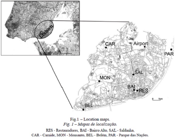
There is also no doubt that steps ought to be taken to adapt to new climate  conditions, already being felt in cities, that may deteriorate in the future. In order to select adaptation measures, every particular city must be previously  studied, as UHI varies in time and space and from city to city. This paper focuses on Lisbon, located near the western coast of Portugal, on the bank of the  Tagus estuary, which is 15 km wide eastwards from Lisbon (<a href="#f1">fig. 1</a>). The city covers 84 km<sup>2</sup>, has circa 600,000 inhabitants and is the centre of a  metropolitan area with nearly 2.5 million people. The city&#8217;s topography (including the city centre) is hilly with steep slopes and altitudinal variations  of over 100 m. northwards, a plateau slopes gently to the north and to the west the Monsanto Hill &#8211; a forested area &#8211; reaches 200 m. The old city  centre lies near the river and the highest buildings are not concentrated here, but rather on its northern and north-western fringes. Lisbon&#8217;s climate is  Mediterranean with mild and rainy winters and hot dry summers (Alcoforado, 1992). </p>       <p>&nbsp;</p> <a name="f1"></a> <img src="/img/revistas/fin/n98/n98a06f1.jpg">     
<p>&nbsp;</p>       <p>Following previous studies of Lisbon&#8217;s climate (Alcoforado,  1992; Andrade, 2003; Lopes, 2003), a mesoscale meteorological network was set up in 2004 to monitor Lisbon&#8217;s UHI, under the guidance of Professor Timothy  Oke. These studies are still ongoing, combining observations and modelling. The preliminary statistical results were published in 2007 (Alcoforado <i>et al., </i> 2007). Their main aim was to produce useful information for urban planning, which has been achieved in collaboration with Lisbon&#8217;s Municipality  (Alcoforado <i>et al.,</i> 2009). </p>       <p>The main goal of the current study is to update the results with new observational data and to present and analyse  the basic statistics of Lisbon&#8217;s heat island. Data on the frequencies of occurrence and of the mean and maximum values of the UHI are essential to decide  which urban planning measures should being taken (Eliasson, 2000; Oke, 2006). </p>       <p>The next section will provide some information about the urban canopy  UHI; section iii will explain how data was acquired. In section IV the methodology used is described. The results are included in section V and discussed in  section VI. The conclusions are presented in section VII. </p>       <p>&nbsp;</p>       <p><b>II. URBAN CANOPY UHI </b></p>       ]]></body>
<body><![CDATA[<p>The urban thermal field is dependent not  only on large scale (synoptic) factors (Berenová and Huth, 2005; Morris <i>et al.,</i> 2001) through the change in cloudiness and regional wind field,  but also on local natural features (such as the topography or the presence of large water bodies) as well as on urban morphology. This means that at any given  time the urban thermal field is the result of the combined effects of the synoptic, natural and urban features, as expressed by the Lowry (1977) <a href="#eq1">equation 1</a>: </p>       <p>&nbsp;</p> <a name="eq1"></a> <img src="/img/revistas/fin/n98/n98a06eq1.jpg">     
<p>&nbsp;</p>      <p>Where<i> M</i> is the value assumed for a given climatic variable in the urban  site <i>x</i>, at the time <i>t </i>and under the weather type <i>i</i>; <i>C </i>is the regional component (determined by large scale features); <i>L </i> stands for the natural local features and <i>U </i>is the urban component. The urban parameter (<i>U</i>) may be explained through the analysis of the urban  energy balance. The following <a href="#eq2">equation 2</a> was proposed by Oke (1988) </p>        <p>&nbsp;</p> <a name="eq2"></a> <img src="/img/revistas/fin/n98/n98a06eq2.jpg">     
<p>&nbsp;</p>        <p><i>Q*</i>  is the net all-wave radiation and <i>Q<sub>F</sub></i> the anthropogenic heat flux. <i>Q<sub>H</sub></i> is the flux of sensible heat, <i>Q<sub>E </sub></i>the  &#64258;ux of latent heat, <i>&#916;</i><i>Q<sub>S</sub></i> is the heat stored in the urban fabric and <i>&#916;</i><i>Q<sub>A</sub></i> represents the net  heat advection (Wm<sup>-2</sup>) </p>       <p>and (<a href="#eq3">eq. 3</a>, <a href="#eq4">eq. 4</a>, <a href="#eq5">eq. 5</a>)</p>       <p>&nbsp;</p> <a name="eq3"></a> <img src="/img/revistas/fin/n98/n98a06eq3.jpg">     
<p>&nbsp;</p>       ]]></body>
<body><![CDATA[<p>&nbsp;</p> <a name="eq4"></a> <img src="/img/revistas/fin/n98/n98a06eq4.jpg">     
<p>&nbsp;</p>       <p>&nbsp;</p> <a name="eq5"></a> <img src="/img/revistas/fin/n98/n98a06eq5.jpg">     
<p>&nbsp;</p>       <p><i>K</i>&#8595; is the short wave solar  radiation, K&#8593; the reflected short wave radiation, <i>L</i>&#8595; the longwave sky radiation and <i>L</i>&#8593; the longwave terrestrial radiation loss.  </p>       <p>We include in this paper a brief summary of the differences of urban and rural energy balance, and a discussion of the modification of the different  terms of the energy balance following Oke (1996), Mills (2004), Grimmond (2007), among many others. It should be remembered that values vary from city to city  and within each city. </p>       <p><i>K</i>&#8595; may be 10% lower than in the country and up to 30% in cities with high levels of pollution due to the high  concentration of aerosols (Jáuregui and Luyando, 1999). However, <i>K</i>&#8593; is frequently lower in the city which is partly due to canyon geometry  (Oke, 1996): the reflecting area is large and multiple reflexion between walls in urban areas of low sky view factors (SVF) cause a lower outward shortwave  radiation (<i>K </i>&#8593;). Besides, surface materials may also modify the albedo (e.g. dark surfaces reflect less energy) and further decrease <i>K </i> &#8593;. Lopes (2003) showed that the albedo is lower in Lisbon than at the periphery (except in Monsanto Hill). As a result <i>K</i> * may be similar in urban  and rural areas or even higher in urban areas. As to longwave radiation, <i>L</i>&#8595; may be increased in urban areas due to air pollution and dust longwave  emission and the longwave lost to the atmosphere <i>L </i>&#8593; may be reduced due to low SVF. So <i>L</i> * will possibly be higher in urban areas, which  means that there will be greater absorption and re-emission of longwave radiation (Grimmond, 2007). </p>       <p>As a result, radiation budget (<i>Q</i>*, <a href="#eq3">eq. 3</a>)  will be higher in urban areas. </p>       <p>The anthropogenic heat flux (<i>Q<sub>F</sub></i>) is higher in cities due to electricity and combustion of fossil  fuels, air conditioning and heating systems, factories, vehicles and even heat from human metabolism (sailor and Lu, 2004). This parameter is very difficult to  compute and the magnitude of the flux depends on the scale of the analysis. It varies a lot from city to city (depending on the latitude, the industrialisation  degree, social-economic development among other factors), within the city and in time (e.g. higher in winter in mid-latitude cities). Its proportion within the  energetic balance depends also on the population density (which varies a lot during the day). Part of (<i>Q<sub>F</sub></i>) is directly emitted in the urban  canopy layer (traffic, air conditioning systems). </p>       <p>The energy input (<i>Q</i>*+ <i>Q<sub>F</sub></i>) is used in different ways in urban areas: </p>       ]]></body>
<body><![CDATA[<p> In many cities, the areas covered by vegetation are lower than in the country and the cities have much more impervious areas. As a result, there is a decrease  in evapotranspiration (latent heat flux <i>Q<sub>E</sub></i>). Then, the energy driving evapotranspiration is lower in the city and there is more energy  available to warm up the air (<i>Q<sub>H</sub></i>, sensible heat flux). The sensible heat flux is defined by Oke (1996) as &#8220;that heat energy able to be  sensed (e.g. with a thermometer)&#8221;. </p>       <p>The surface materials&#8217; thermal characteristics have particular &#8220;radiative properties (albedo and  the emissivity), as well as conductive properties (thermal admittance and conductivity)&#8221;, as Grimmond (2007) pointed out, which influence the surface  temperature and heat storage (&#916;<i>Q<sub>S</sub></i>). In most cases, heat stored during the day is transferred by night to the urban atmosphere. Studies  conducted in Lisbon have shown that the ratio <i>Q<sub>S</sub></i>/<i>Q</i>* attains 55% in the more densely built part of the city (southern city districts),  versus 1.2% in the airport and the forested hill in western Lisbon (Lopes and Vieira, 2001). </p>       <p>Finally, the advection factor (<i>&#916;</i><i>Q<sub>A </sub></i>) is the neat heat advection. The wind speed decreases in the city due to surface roughness caused by the buildings. This has been verified in Lisbon  by Lopes <i>et al.</i> (2011) and will be discussed below. </p>       <p>In conclusion, UHI can be controlled by a large set of factors the most important of which  are the modification in radiation balance, the emission of anthropogenic heat, the reduction in evapotranspiration from vegetation and soils, the thermal  accumulation in buildings and pavements and the reduction of average wind speed (Oke, 1996; Arnfield, 2003). </p>       <p>&nbsp;</p>       <p><b>III. MONITORING LISBON UHI </b></p>      <p><b>1. First networks </b></p>       <p>The first studies carried out in Lisbon were based on itinerant temperature and humidity measurements (Alcoforado, 1992).  The same route was repeated circa 60 times, using an <i>Assman </i>Psycrometer to measure temperature and humidity at 1.5 m above the ground. Alcoforado  (1992) calculated a mean UHI intensity of 2.5&ordm;C and described night-time (higher) UHI and the fact that during the day, there are &#8220;cool islands &#8221; in southern Lisbon either due to the sea-breeze (in the warm semester) or to winter radiation fog from the Tagus estuary. Some spatial interpolation  experiments were carried out (Alcoforado, 1994). </p>       <p>Later, an <i>early mesoscale network</i> was temporarily set up and was the basis of Henrique Andrade &#8217;s PhD thesis (Andrade, 2003). The 12 sensors were accurate <i>Gemini Data Loggers&#8217; Tiny Talks</i> (Alcoforado and Andrade, 2006). Andrade&#8217;s  (2003) work was also based on data from a microscale network in a city district in northern Lisbon (Andrade, 2003 and Andrade and Alcoforado, 2008). Among  other results, Andrade (2003) confirmed and further studied Lisbon&#8217;s thermal patterns, developed the spatial interpolation processes, constructed rather  detailed thermal maps, and initiated the study of human bioclimatology of Lisbon. </p>       <p><b>2. Permanent mesoscale network
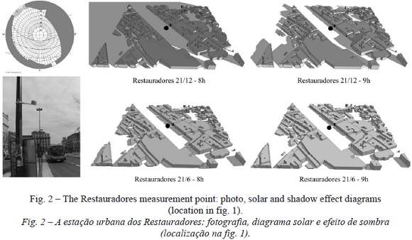
 </b></p>       ]]></body>
<body><![CDATA[<p>In 2004, a permanent  mesoscale network of 7 <i>Geminy</i> temperature and humidity data loggers (model <i>TinyTag Plus</i>) was set up under the framework of the ClimLis  project. The devices were fixed to lamp posts at a height of approximately 3.5 m and at a distance of nearly 1 m from the post&#8217;s surface, hence avoiding  its thermal influence (<a href="#f2">fig. 2</a>). </p>        <p>&nbsp;</p> <a name="f2"></a> <img src="/img/revistas/fin/n98/n98a06f2.jpg">     
<p>&nbsp;</p>       <p>Records were made at 15 minute intervals, but only the average values over each hour period were analysed. In this  paper 13,000 days from 2004 until 2012 are examined. </p>       <p>
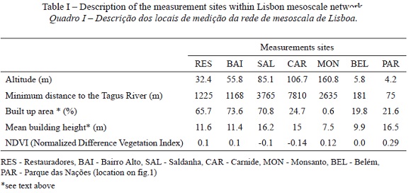
The sensors were disseminated as regularly as possible within the city. Two sensors were located  near the Tagus River (BEL, PAR), one on Monsanto Hill (MON), three in the city centre (RES, BAI, SAL) and one in the northern boundary of Lisbon (CAR). The  sites&#8217; geographical characteristics are included in <a href="#t1">table I</a> and their location shown in <a href="#f1">figure 1</a>. Their altitude varies from under 10 m (BEL and Par)  right on the Tagus Bank to 160.8 m (MON). The altitude of RES, SALD and CAR rises as their distance from the river increases. Bai, located on a southern hill  of Lisbon, was installed later (2005) and will not be included in this analysis. The percentage of builtup area (measured within a 500 m square, centred over  the observation site, Alves and Biudes, 2013) is the highest in res, BAI and SAL and is next to 0 in MON. The measurement sites are relatively open places, all  of them with SVF &gt;0.69 (Andrade, 2003), avoiding the influence of microclimatic factors, since the main objective was the study of the mesoscale thermal  field (Oke, 2006). In order to interpret the results, each measuring point was characterized as exemplified in <a href="#f2">figure 2</a> for res, a measuring point within the  CBD. Solar and shadow effect diagrams show that although RES is in the city-centre, it stays in the shade only until just before 9:00 h, even in winter.  Monthly/hourly shadow effects are displayed in <a href="#f7">figure 7</a>. </p>        <p>&nbsp;</p> <a name="t1"></a> <img src="/img/revistas/fin/n98/n98a06t1.jpg">     
<p>&nbsp;</p>      <p>&nbsp;</p> <a name="f3"></a> <img src="/img/revistas/fin/n98/n98a06f3.jpg">     
<p>&nbsp;</p>      <p>&nbsp;</p> <a name="f4"></a> <img src="/img/revistas/fin/n98/n98a06f4.jpg">     
]]></body>
<body><![CDATA[<p>&nbsp;</p>      <p>&nbsp;</p> <a name="f5"></a> <img src="/img/revistas/fin/n98/n98a06f5.jpg">     
<p>&nbsp;</p>      <p>&nbsp;</p> <a name="f6"></a> <img src="/img/revistas/fin/n98/n98a06f6.jpg">     
<p>&nbsp;</p>       <p>&nbsp;</p> <a name="f7"></a> <img src="/img/revistas/fin/n98/n98a06f7.jpg">     
<p>&nbsp;</p>       <p>A temporary microclimatic network was also installed in one city-district (Telheiras, northern  Lisbon) in order to determine the influence of street orientation, buildings&#8217; shape, height to width ratio (Landsberg, 1981), presence/absence of trees  and traffic on temperature, humidity and wind (Andrade, 2003; Lopes, 2003; Andrade and Alcoforado, 2008; Alcoforado, 2010a). However, the results will not be  dealt with here. </p>       <p>&nbsp;</p>       <p><b>IV. METHODOLOGY </b></p>       ]]></body>
<body><![CDATA[<p>The urban heat island results from the fact that &#8220;the air in the urban canopy is  usually warmer than that in the surrounding&#8221; (Oke, 1996: 288). Following the same source the difference between the &#8220;peak&#8221; temperature in the  city centre and &#8220;the background rural temperature defines the urban heat island intensity&#8221; (Oke, 1996: 289). This seems quite simple<i>. </i></p>        <p>However, it is difficult to find universal criteria to calculate the UHI intensity (UHII). In different studies, authors calculate UHI intensities in very  different ways. As pointed out by steward (2010) special attention should be given to site selection and temporal resolution of data. Hourly data are used in  the current study. Furthermore, the data from the different sensors located in urban and sub-urban areas, following T. Oke&#8217;s rules (2006), were analysed  in order to select appropriate sites to UHI calculation and three procedures were carried out. </p>     <p><b>1. Thermal similarities among city measurement sites  </b></p>     <p><b><i>1.1. Comparison of thermal characteristics of measuring sites </i></b></p>       <p>First of all, the number of times each measuring point was  the hottest or the coldest was counted and the frequency of both occurrences was calculated. it is clear from <a href="#t2">table II</a>, that the more central measuring points  (RES, BAI, SAL) are the hottest ones by night (sum of the bold figures on column 4: 96.4%) and by day (sum of the bold figures on column 4: 83.37%). CAR and  MON are nearly always the coldest ones (sum of the italic figures on column 3 and 5, respectively: 99.7% by night and 83.6%). it is interesting to note that  MON (on the forested hill, but in a site with high SVF) has a much higher frequency of coldest nights (92.8%) than Car (6.9%). </p>        <p>&nbsp;</p> <a name="t2"></a> <img src="/img/revistas/fin/n98/n98a06t2.jpg">     
<p>&nbsp;</p>       <p><b><i>1.2. Temperature  deviations from the Airport </i></b></p>       <p>
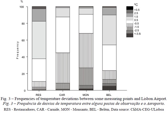
Then we calculated for each location the percentage of hourly temperature deviations between that site and the  Lisbon airport, located in the northern part of the city (<a href="#f1">fig.1</a>). The airport had already been used as a reference station in early urban climate studies of  Lisbon (Alcoforado, 1992), because it is in a windward situation towards Lisbon in the very frequent situations of n winds (Lopes <i>et al.,</i> 2011). </p>       <p> Some results are plotted in <a href="#f3">figure 3</a>. The white part of the columns correspond to situations with slight temperature deviations (0.5&ordm;C&lt;&#916;T&lt;+0.5 &ordm;C); the grey scale corresponds to positive deviations (&#916;T&gt;+0.5&ordm;C) when the city is hotter than the Airport; the stripes relates to negative  deviations (&#916;T &lt;0.5&ordm;C), when the city is cooler than the airport. RES (<a href="#f1">fig. 1</a> and <a href="#f2">2</a>) is hotter than the airport in more than 60% of the hours ( &#916;T &gt;+0.5&ordm;C), 20% of which superior to +1.5&ordm;C and 3% superior to +2.5&ordm;C. Saldanha (SAL, not shown) is hotter than the airport in 45% of  the hourly intervals, that is 15% less than res, probably due to its more north exposed site than Res. Saldanha&#8217;s square lays within the ventilation path  through a large n-s street (Alcoforado <i>et al.,</i> 2009). </p>       ]]></body>
<body><![CDATA[<p>The frequency of positive deviations (&#916;T &gt;+0.5&ordm;C) decreases in the peripheral  sites: 15% in CAR and 10% in MON. This site, located in a forested urban hill in western Lisbon, has the highest frequency (70%) of negative deviations to the  airport, 10% &#916;T lower than 2.5&ordm;C and 3% &#916;T lower than 2.5&ordm;C. </p>       <p>In CAR, 45% of the deviations are lower than -1.5&ordm;C. BEL has a  relatively high percentage (55%) of positive deviations (&#916;T &gt;+0.5&ordm;C) to the Airport, most probably due to its position in SW Lisbon, more directly  submitted to warmer ocean air in the winter semester. Negative deviations (&#916;T &lt;0.5&ordm;C) attain circa one fourth of the cases, due to the advection  of cooler summer air. </p>     <p><b><i>1.3. Classification of measuring points based on their thermal deviations to the Airport. </i></b></p>       <p>
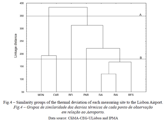
Next, a tree  clustering analysis (based on the linkage distance) of the thermal deviations between urban stations and the airport was carried out. The results are expressed  on the dendrogram in <a href="#f4">figure 4</a>. MON and CAR, the peripheral stations, are isolated from the five other more central stations, as expected (level a). Detailing  the analysis (lower linkage distance, level B), the three stations of the city centre (RES, SAL and BAI) form a group, separated from the two riverside  measuring points. </p>       <p>In view of these results, RES and SAL were used as &#8220;central city measuring points&#8221; (BAI had a shorter measuring period)  and Car and MON were used as peripheral sites. The riverside areas (BEL and PAR) were not considered in this analysis owing to the influence of the Tagus River  and the Ocean (particularly summer sea breezes and winter radiation fogs), that in these two particular sites may overlap the urban effect (Sakakibara and Owa,  2005; Alcoforado, 1992; Alcoforado <i>et al., </i>2006). Their particular thermal behaviour is reflected in their separation from the central sites on the  dendrogram (BEL and PAR in <a href="#f3">fig. 3</a>). </p>       <p><b>2. Criteria to calculate UHI intensity </b></p>       <p>Following Oke (1996) and Andrade  (2003) and based on the comparisons described above, the occurrence of the UHI in Lisbon was considered each time the temperature in the central sites (SAL and  RES) was higher than the temperature registered in the peripheral locations (MON and CAR). The intensity of the UHI (UHII) was calculated as the difference, at  a specific moment, between the central and the peripheral sites following the equation: </p>       <p><i>UHII = T<sub>C</sub> &#8211; T<sub>P</sub></i> (1) </p>       <p> Where <i>T<sub>C</sub></i> corresponds to the highest air temperature of the two <b>c</b>entral sites, and <i>T<sub>P</sub></i> the lowest air temperature of  the peripheral sites. </p>       <p>&nbsp;</p>       ]]></body>
<body><![CDATA[<p><b>IV. RESULTS: DAILY AND MONTHLY VARIATION OF LISBON&#8217;S UHI </b></p>       <p>
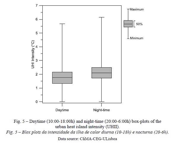
The data was divided into night-time  (20:00-6:00h) and daytime observations (10:00 to 18:00h), discarding the times close to sunrise and sunset, when the radiation conditions can cause thermal  anomalies due to the shadowing of the facets. </p>       <p>In <a href="#f5">figure 5</a>, the median UHI is slightly lower by day (1.6&ordm;C) than by night (2.1&ordm;C). The first  quartile is higher by night (1.7 versus 1.3&ordm;C by day), as well as the third quartile (2.5 versus 2.2&ordm;C by day). Maximum UHII during the studied  period is 6.3&ordm;C (by night) and 5.7&ordm;C (by day). However, these slight differences hide great temporal and spatial differences, which further analysis  will unveil.
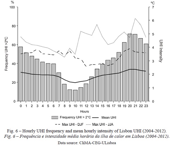
 </p>        <p><a href="#f6">Figure 6</a> discloses more details related to daily variability of air temperature in Lisbon. First of all, it is clear that the frequency of  UHII &gt;2&ordm;C is lower from 9 to 11a.m. (&lt;20% of the cases). It increases during late afternoon and attains its maximum value around 20-21:00h (70% of  the cases) and diminishes slowly towards dawn. This is quite similar to the general scheme explained by T. Oke (1996) and discussed below. The mean UHII,  however, does not show such a great daily variation, although it is lower during the day (1.8&ordm;C) than in the evening and night (2.0&ordm;C). The values  are very close to the median, displayed in <a href="#f5">figure 5</a>, which denotes a symmetrical distribution. Nonetheless, maximum UHII is reached in summer afternoons and  more so in the evenings (up to 6&ordm;C). In winter, maximum UHII fluctuates between 3 and 4&ordm;C, slightly higher in the evening than in the afternoon.
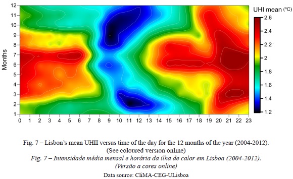
 </p>        <p>Finally, <a href="#f7">figure 7</a> plots UHII at different times throughout the whole year, showing large differences. The lower daytime UHII occurs earlier and lasts less  in summer than in winter. The night-time maximum is higher and lasts longer during the summer months. The afternoon evening increase of UHII (more than 2&ordm; C) in summer begins much earlier (14:00h) than the winter one (circa 19:00h). In the discussion, these findings will be put into context and further explained.  </p>        <p>&nbsp;</p>       <p><b>V. DISCUSSION </b></p>       <p>The urban climate is quite specific to each city. nevertheless, the Mediterranean cities have a fair  amount of points in common (Montávez <i>et al</i>., 2000; Santamouris, 2007; Kolokotsa <i>et al., </i>2009): an evening/night-time maximum occurs in  most cities; maximum UHI takes place in the summer (except for Barcelona, Moreno-Garcia, 1994) and afternoon cool island may occur due to shadow effect,  storage of energy inside buildings (&#916;Qs) and in several cities to the occurrence of seabreezes, as in nice (Carrega, 1992) and Marseille (Lemonsu <i>et al </i>., 2006). </p>       <p>
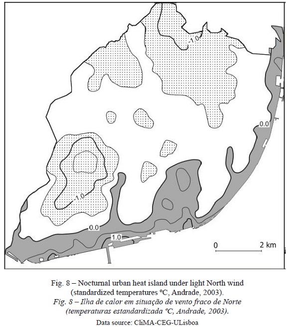
In Lisbon, summer UHII values are the highest (mean values of 2.6&ordm;C, as mentioned above). nocturnal maximal is caused by different  factors, such as heat released by the buildings (&#916;Qs), more anthropogenic heat (QF) released into the atmosphere, eventually less latent heat released  (Qe) by dew formation, less heat used for evapotranspiration (also Qe) and in some cases higher radiation balance (Q*, less outward longwave radiation due to  low sky-view factors). This last factor is probably less important in Lisbon, because both res and SAL measuring sites are set in areas with sky-view factors  &gt;0.69. Lisbon&#8217;s UHI is also due to shelter from cold (in winter) and cool (in summer) prevailing north winds in the valley beds and lower altitudes of  the southern part of the city (which coincides partly with the CBD, <a href="#f8">fig. 8</a>). </p>        <p>&nbsp;</p> <a name="f8"></a> <img src="/img/revistas/fin/n98/n98a06f8.jpg">     
]]></body>
<body><![CDATA[<p>&nbsp;</p>        <p>One very interesting feature in <a href="#f7">figure 7</a> is the fact that, in summer, high  UHII begins quite early in the afternoon, which can be explained by the wind regime in the city (Alcoforado, 1987; Lopes <i>et al</i>., 2013). in the summer  mornings, there are frequently e and SE breezes from the Tagus estuary that veer to the s and SW by midday or later, bringing cooler air into the river-site  city centre, sometimes up to res (Andrade, 2003) and in summer cause a negative heat island from 9:00h to 12:00h (or later). This negative heat island does not  appear in the mean values, but it is clear from several study-cases (Alcoforado <i>et al.,</i> 2006). In the afternoon, at least in 40% of the cases, the  sea-breeze is replaced by north gradient wind. During the time the north wind is blowing, the southern and central part of the city is sheltered and a positive  UHI develops quite early (15 h or even earlier, <a href="#f7">fig. 7</a>). </p>       <p>The relationship between UHII and wind has been studied and verified recently by Lopes <i>et al </i>. (2013). The plots of UHII versus wind speed show an expected reduction of UHI intensity when wind exceeds 4 m/s (<a href="#f9">fig. 9</a>). However, UHI still persists and  its intensity may reach 2&ordm;C under wind speeds of 18 m/s. This is due to the shelter effect, mentioned above. It is interesting to note that with wind  speeds above 12 m/s UHII is never close to 0, meaning that the shelter effect is really important. Some authors do not consider this factor to cause a real UHI  (stewart, 2010). However, it is difficult to separate the different causes and shelter effect is not only caused by topography but also by high-rise buildings,  so it is a result from city morphology. This dual effect is discussed in Andrade <i>et al</i>. (2010). </p>       <p>&nbsp;</p> <a name="f9"></a> <img src="/img/revistas/fin/n98/n98a06f9.jpg">     
<p>&nbsp;</p>       <p>
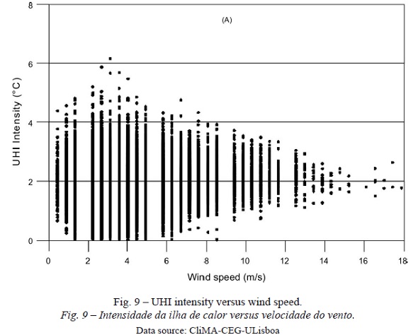
The maximum UHII in Lisbon does not occur in  calm situations, following the general rule (Oke, 1996), but with light winds, where shelter effect accumulates with urban causes and may generate UHII up to 6 &ordm;C (<a href="#f9">fig. 9</a>). In very light wind situations (below 2 m/s) UHII decreases (maximum circa 4&ordm;C). This is explained in the summer by sea-breeze  situations, bringing fresher air to the down-town area and in winter by the occurrence of foggy situations. The relationship between UHI and wind direction is  not so clear and is discussed in Lopes <i>et al</i>. (2013). </p>       <p>We are aware that statistical analysis has weaknesses, particularly the inability &#8220; to present several physical phenomena&#8221; (Mirzaei and Haghighat, 2010). Moreover, there are generally a limited number of stations and of meteorological  parameters measured, not always for a long period of time, necessary to &#8220;filter the unpredictable errors&#8221; (<i>idem</i>). However, measurements are  necessary to validate numerical or physical models and we have now a relatively long series of urban measurements; furthermore, measurement points have been  selected with tight criteria following Oke (2006). </p>       <p>&nbsp;</p>       <p><b>VI. CONCLUSION </b></p>       <p>In this research work, more details and statistical information about  Lisbon&acute;s thermal climate are divulged, now based on hourly data from 8 years (2004-2012) of the <i>Mesoscale Measurement Network</i> of the CliMa  research group. For science sake and for urban planning procedures, it is essential to identify the frequency of the Lisbon UHI to decide if (and which)  adaptation measures should be applied. </p>       ]]></body>
<body><![CDATA[<p>The areas with higher temperatures occur in the &#8220;Baixa&#8221; (res site) and the &#8220;Avenidas Novas &#8221; (SAL site). Nevertheless, there is a great spatial and temporal variability of the UHII. This paper concentrates on its temporal variability. The  median UHII varies from 1.5&ordm;C in summer to 2.1&ordm;C in winter. Maximum values may attain circa 6&ordm;C in summer afternoons, evening and nights.  Minimum frequencies of UHII &gt;2&ordm;C, as detected in this research, correspond to the time spanning from 8:00 to11:00 h. This is only partly due to shadow  effect, as we have verified that at least after 9:00 h there is direct solar radiation on the measuring sites (<a href="#f2">fig. 2</a> shows the example of res measuring  point). During the morning, energy is stored within the buildings (&#916;Qs) and air temperature is generally lower than in nonurban open spaces. Maximum  values occur during the night, particularly in the summer when, among other factors, &#916;Qs is released to the urban canopy layer, after sunset and during  part of the night. The maximum UHII in Lisbon does not occur in calm situations but in light wind conditions, where shelter effect accumulates with urban  causes and may generate UHII up to 6&ordm;C. </p>       <p>This paper is focused on temporal variability of Lisbon&#8217;s UHII. The current data set is also being  used in a paper (in preparation) updating the study of Lisbon&#8217;s spatial thermal patterns. </p>       <p>&nbsp;</p>       <p><b>BIBLIOGRAPHY </b></p>       <!-- ref --><p>Alcoforado M J (2010a) Assessing and modelling the urban climate in Lisbon. <i>In</i>  Carrega P (ed.) <i>Geographical Information and Climatology</i>. ISTE &amp; WiLey, London &amp; Hoboken: 125-158.    &nbsp;&nbsp;&nbsp;&nbsp;&nbsp;&nbsp;&nbsp;&nbsp;[&#160;<a href="javascript:void(0);" onclick="javascript: window.open('/scielo.php?script=sci_nlinks&ref=000137&pid=S0430-5027201400020000600001&lng=','','width=640,height=500,resizable=yes,scrollbars=1,menubar=yes,');">Links</a>&#160;]<!-- end-ref --> </p>       <!-- ref --><p>Alcoforado M J (2010b) <i>Climatologia urbana para o ensino</i>. CliMa, 3, CEG,  Lisboa.    &nbsp;&nbsp;&nbsp;&nbsp;&nbsp;&nbsp;&nbsp;&nbsp;[&#160;<a href="javascript:void(0);" onclick="javascript: window.open('/scielo.php?script=sci_nlinks&ref=000139&pid=S0430-5027201400020000600002&lng=','','width=640,height=500,resizable=yes,scrollbars=1,menubar=yes,');">Links</a>&#160;]<!-- end-ref --> </p>       <!-- ref --><p>Alcoforado M J (1994) L&#8217;extrapolation spatiale des donn &eacute;es thermiques en milieu urbain. <i>Publications de l&#8217;Association Internationale de Climatologie</i>, 6: 493-502.    &nbsp;&nbsp;&nbsp;&nbsp;&nbsp;&nbsp;&nbsp;&nbsp;[&#160;<a href="javascript:void(0);" onclick="javascript: window.open('/scielo.php?script=sci_nlinks&ref=000141&pid=S0430-5027201400020000600003&lng=','','width=640,height=500,resizable=yes,scrollbars=1,menubar=yes,');">Links</a>&#160;]<!-- end-ref --> </p>       ]]></body>
<body><![CDATA[<!-- ref --><p>Alcoforado M J (1992) <i>O clima da região de Lisboa. Contrastes e ritmos t &eacute;rmicos</i>. Memórias do CEG, Lisboa,    &nbsp;&nbsp;&nbsp;&nbsp;&nbsp;&nbsp;&nbsp;&nbsp;[&#160;<a href="javascript:void(0);" onclick="javascript: window.open('/scielo.php?script=sci_nlinks&ref=000143&pid=S0430-5027201400020000600004&lng=','','width=640,height=500,resizable=yes,scrollbars=1,menubar=yes,');">Links</a>&#160;]<!-- end-ref --> 15. </p>       <!-- ref --><p>Alcoforado M J  (1987) Brisas estivais do tejo e do oceano na região de Lisboa. <i>Finisterra &#8211; Revista Portuguesa de Geografia</i>, XXII(43):71-112.    &nbsp;&nbsp;&nbsp;&nbsp;&nbsp;&nbsp;&nbsp;&nbsp;[&#160;<a href="javascript:void(0);" onclick="javascript: window.open('/scielo.php?script=sci_nlinks&ref=000145&pid=S0430-5027201400020000600005&lng=','','width=640,height=500,resizable=yes,scrollbars=1,menubar=yes,');">Links</a>&#160;]<!-- end-ref --> </p>       <!-- ref --><p>Alcoforado M J, Andrade H (2008) Global warming and urban heat island. <i>In</i>  Marzluff JM, Shulenberger E, Endlicher W, Alberti M, Bradley G, Ryan C, Simon U, Zumbrunnen C (eds.) <i>Urban Ecology</i>. Springer: 249-262.    &nbsp;&nbsp;&nbsp;&nbsp;&nbsp;&nbsp;&nbsp;&nbsp;[&#160;<a href="javascript:void(0);" onclick="javascript: window.open('/scielo.php?script=sci_nlinks&ref=000147&pid=S0430-5027201400020000600006&lng=','','width=640,height=500,resizable=yes,scrollbars=1,menubar=yes,');">Links</a>&#160;]<!-- end-ref --> </p>       <!-- ref --><p>Alcoforado MJ, Andrade H (2006) Nocturnal urban heat island in Lisbon (Portugal): Main  features and modelling attempts. <i>Theoretical and Applied Climatology,</i> 84(1-3): 151-159.    &nbsp;&nbsp;&nbsp;&nbsp;&nbsp;&nbsp;&nbsp;&nbsp;[&#160;<a href="javascript:void(0);" onclick="javascript: window.open('/scielo.php?script=sci_nlinks&ref=000149&pid=S0430-5027201400020000600007&lng=','','width=640,height=500,resizable=yes,scrollbars=1,menubar=yes,');">Links</a>&#160;]<!-- end-ref --> </p>       <p>Alcoforado M J, Andrade H, Lopes A (2010) Clima e ordenamento urbano na escala  microclimática: o exemplo do bairro de Telheiras em Lisboa. <i>In </i>Figueiredo <i>et al.</i> (eds.) <i>Clima e recursos naturais. </i>Instituto  Polit&eacute;cnico de Bragan&ccedil;a: 43-82. </p>       <!-- ref --><p>Alcoforado M J, Andrade H,  Lopes A, Vasconcelos J (2009) Application of climatic guidelines to urban planning the example of Lisbon (Portugal). <i>Landscape and Urban Planning</i> , 90: 56-65.    &nbsp;&nbsp;&nbsp;&nbsp;&nbsp;&nbsp;&nbsp;&nbsp;[&#160;<a href="javascript:void(0);" onclick="javascript: window.open('/scielo.php?script=sci_nlinks&ref=000152&pid=S0430-5027201400020000600009&lng=','','width=640,height=500,resizable=yes,scrollbars=1,menubar=yes,');">Links</a>&#160;]<!-- end-ref --></p>       <!-- ref --><p>Alcoforado M J, Andrade H, Lopes A, Oliveira S (2007) A ilha  de calor em Lisboa. Aquisição de dados e primeiros resultados estatísticos para aplicação ao ordenamento urbano. <i>In </i> Centro de Estudos Geográficos CEG (ed.) <i>Geophilia - o sentir e os sentidos da Geografia. Homenagem a Jorge Gaspar: </i>593-612.    &nbsp;&nbsp;&nbsp;&nbsp;&nbsp;&nbsp;&nbsp;&nbsp;[&#160;<a href="javascript:void(0);" onclick="javascript: window.open('/scielo.php?script=sci_nlinks&ref=000154&pid=S0430-5027201400020000600010&lng=','','width=640,height=500,resizable=yes,scrollbars=1,menubar=yes,');">Links</a>&#160;]<!-- end-ref -->  </p>       <!-- ref --><p>Alcoforado MJ, Andrade H, Lopes A, Vasconcelos J, Vieira R (2006)  Observational studies on summer winds in Lisbon (Portugal) and their influence on daytime regional and urban thermal patterns. <i>Merhavim</i>, 6: 90-112.    &nbsp;&nbsp;&nbsp;&nbsp;&nbsp;&nbsp;&nbsp;&nbsp;[&#160;<a href="javascript:void(0);" onclick="javascript: window.open('/scielo.php?script=sci_nlinks&ref=000156&pid=S0430-5027201400020000600011&lng=','','width=640,height=500,resizable=yes,scrollbars=1,menubar=yes,');">Links</a>&#160;]<!-- end-ref --> </p>       <!-- ref --><p>Alves EDL, Biudes MS (2013) Method for determining the footprint area of air  temperature and relative humidity. <i>Acta Scientiarum. Technology</i>, 35(2): 187-194.    &nbsp;&nbsp;&nbsp;&nbsp;&nbsp;&nbsp;&nbsp;&nbsp;[&#160;<a href="javascript:void(0);" onclick="javascript: window.open('/scielo.php?script=sci_nlinks&ref=000158&pid=S0430-5027201400020000600012&lng=','','width=640,height=500,resizable=yes,scrollbars=1,menubar=yes,');">Links</a>&#160;]<!-- end-ref --> </p>       <!-- ref --><p>Andrade H (2003) <i>Bioclima humano e Temperatura do ar em Lisboa (Human Bioclimate  and Air Temperature in Lisbon). </i>PhD in Physical Geography, University of Lisbon, Lisbon.    &nbsp;&nbsp;&nbsp;&nbsp;&nbsp;&nbsp;&nbsp;&nbsp;[&#160;<a href="javascript:void(0);" onclick="javascript: window.open('/scielo.php?script=sci_nlinks&ref=000160&pid=S0430-5027201400020000600013&lng=','','width=640,height=500,resizable=yes,scrollbars=1,menubar=yes,');">Links</a>&#160;]<!-- end-ref --> </p>       <!-- ref --><p>Andrade A, Alcoforado M J, Canário P (2010) estimação da influ &ecirc;ncia antrópica no campo t&eacute;rmico de Lisboa; uma tentativa de modelação estatística. <i>II Workshop Internacional sobre  Clima e Recursos Naturais nos Países de Língua Portuguesa. </i>Bragan&ccedil;a: 207-214.    &nbsp;&nbsp;&nbsp;&nbsp;&nbsp;&nbsp;&nbsp;&nbsp;[&#160;<a href="javascript:void(0);" onclick="javascript: window.open('/scielo.php?script=sci_nlinks&ref=000162&pid=S0430-5027201400020000600014&lng=','','width=640,height=500,resizable=yes,scrollbars=1,menubar=yes,');">Links</a>&#160;]<!-- end-ref --> </p>       <!-- ref --><p>Andrade H, Alcoforado M J (2008b) Microclimatic variation of thermal comfort in a  district of Lisbon (Telheiras) at night. <i>Theoretical and Applied Climatology</i>, 92(3-4): 225-237.    &nbsp;&nbsp;&nbsp;&nbsp;&nbsp;&nbsp;&nbsp;&nbsp;[&#160;<a href="javascript:void(0);" onclick="javascript: window.open('/scielo.php?script=sci_nlinks&ref=000164&pid=S0430-5027201400020000600015&lng=','','width=640,height=500,resizable=yes,scrollbars=1,menubar=yes,');">Links</a>&#160;]<!-- end-ref --> </p>       <!-- ref --><p>Arnfield J (2003) Two decades of urban climate research: a review of turbulence,  exchanges of energy and water and the urban heat island. <i>International Journal of Climatology</i>, 23:1-26.    &nbsp;&nbsp;&nbsp;&nbsp;&nbsp;&nbsp;&nbsp;&nbsp;[&#160;<a href="javascript:void(0);" onclick="javascript: window.open('/scielo.php?script=sci_nlinks&ref=000166&pid=S0430-5027201400020000600016&lng=','','width=640,height=500,resizable=yes,scrollbars=1,menubar=yes,');">Links</a>&#160;]<!-- end-ref --> </p>       <!-- ref --><p>Beranová R, Huth R (2005) Long-term changes in the heat island of Prague under  different synoptic conditions. <i>Theoretical and Applied Climatology</i>, 82: 113-118.    &nbsp;&nbsp;&nbsp;&nbsp;&nbsp;&nbsp;&nbsp;&nbsp;[&#160;<a href="javascript:void(0);" onclick="javascript: window.open('/scielo.php?script=sci_nlinks&ref=000168&pid=S0430-5027201400020000600017&lng=','','width=640,height=500,resizable=yes,scrollbars=1,menubar=yes,');">Links</a>&#160;]<!-- end-ref --> </p>       <!-- ref --><p>Carrega P (1992) <i>Topoclimatologie et habitat</i>. Th&egrave;se d &#8217;&Eacute;tat, Universit&eacute; de nice,    &nbsp;&nbsp;&nbsp;&nbsp;&nbsp;&nbsp;&nbsp;&nbsp;[&#160;<a href="javascript:void(0);" onclick="javascript: window.open('/scielo.php?script=sci_nlinks&ref=000170&pid=S0430-5027201400020000600018&lng=','','width=640,height=500,resizable=yes,scrollbars=1,menubar=yes,');">Links</a>&#160;]<!-- end-ref --> nice. </p>       <!-- ref --><p>Eliasson I (2000)  The use of climate knowledge in urban planning. <i>Landscape and Urban Planning</i>, 48: 31-44.    &nbsp;&nbsp;&nbsp;&nbsp;&nbsp;&nbsp;&nbsp;&nbsp;[&#160;<a href="javascript:void(0);" onclick="javascript: window.open('/scielo.php?script=sci_nlinks&ref=000172&pid=S0430-5027201400020000600019&lng=','','width=640,height=500,resizable=yes,scrollbars=1,menubar=yes,');">Links</a>&#160;]<!-- end-ref --> </p>       <!-- ref --><p>Gabriel K M A, Endlicher W R (2011) Urban and rural mortality rates during heat waves  in Berlin and Brandenburg, Germany. <i>Environmental pollution</i>, 159 (8-9): 2044-2050.    &nbsp;&nbsp;&nbsp;&nbsp;&nbsp;&nbsp;&nbsp;&nbsp;[&#160;<a href="javascript:void(0);" onclick="javascript: window.open('/scielo.php?script=sci_nlinks&ref=000174&pid=S0430-5027201400020000600020&lng=','','width=640,height=500,resizable=yes,scrollbars=1,menubar=yes,');">Links</a>&#160;]<!-- end-ref --> </p>       <p>Grimmond S (2007) Urbanization and global environmental change: local effects of urban  warming. <i>Cities and global environmental change</i>: 83-88. </p>       <!-- ref --><p>Já uregui E, Luyando E (1999) Global radiation attenuation by air pollution and its effects on the thermal climate in Mexico City. <i>International Journal of  Climatology, </i>19(6):683-69. DOi: 10.1002/(Sici)10970088(199905)19:6&lt;683::aiD-JOC389&gt;3.0.CO;2-8 &nbsp;&nbsp;&nbsp;&nbsp;&nbsp;&nbsp;&nbsp;&nbsp;[&#160;<a href="javascript:void(0);" onclick="javascript: window.open('/scielo.php?script=sci_nlinks&ref=000177&pid=S0430-5027201400020000600022&lng=','','width=640,height=500,resizable=yes,scrollbars=1,menubar=yes,');">Links</a>&#160;]<!-- end-ref --><!-- ref --><p>Kolokotsa D, Psomas A, Karapidais E (2009) Urban heat island in southern Europe: the  case study of Hania, Crete. <i>Solar Energy</i>, 83: 1871-1883.    &nbsp;&nbsp;&nbsp;&nbsp;&nbsp;&nbsp;&nbsp;&nbsp;[&#160;<a href="javascript:void(0);" onclick="javascript: window.open('/scielo.php?script=sci_nlinks&ref=000178&pid=S0430-5027201400020000600023&lng=','','width=640,height=500,resizable=yes,scrollbars=1,menubar=yes,');">Links</a>&#160;]<!-- end-ref --> </p>       <!-- ref --><p> Landsberg HE (1981) <i>The urban climate</i>. Elsevier science.    &nbsp;&nbsp;&nbsp;&nbsp;&nbsp;&nbsp;&nbsp;&nbsp;[&#160;<a href="javascript:void(0);" onclick="javascript: window.open('/scielo.php?script=sci_nlinks&ref=000180&pid=S0430-5027201400020000600024&lng=','','width=640,height=500,resizable=yes,scrollbars=1,menubar=yes,');">Links</a>&#160;]<!-- end-ref --> </p>       <!-- ref --><p> Lemonsu A, Pigeon G, Masson V, Moppert C (2006) sea-town interactions over Marseille: 3D urban boundary layer and thermodynamic fields near the surface. <i> Theoretical and Applied Climatology, </i>84(1-3):171-178. DOi: 10.1007/s00704-005-0155-y &nbsp;&nbsp;&nbsp;&nbsp;&nbsp;&nbsp;&nbsp;&nbsp;[&#160;<a href="javascript:void(0);" onclick="javascript: window.open('/scielo.php?script=sci_nlinks&ref=000182&pid=S0430-5027201400020000600025&lng=','','width=640,height=500,resizable=yes,scrollbars=1,menubar=yes,');">Links</a>&#160;]<!-- end-ref --><!-- ref --><p>Lopes A (2003) <i>Lisbon climate modification due to the urban growth wind, surface  heat island and energy balance. </i>PhD in Physical Geography, University of Lisbon, Lisbon.    &nbsp;&nbsp;&nbsp;&nbsp;&nbsp;&nbsp;&nbsp;&nbsp;[&#160;<a href="javascript:void(0);" onclick="javascript: window.open('/scielo.php?script=sci_nlinks&ref=000183&pid=S0430-5027201400020000600026&lng=','','width=640,height=500,resizable=yes,scrollbars=1,menubar=yes,');">Links</a>&#160;]<!-- end-ref --> </p>       <p>Lopes A, Vieira H (2001) Heat fluxes from Landsat images: a contribution to Lisbon  urban planning. <i>Regensburg Geographische Schriften</i>, 169-173. </p>       <!-- ref --><p> Lopes A, Saraiva J, Alcoforado M J (2011) Urban boundary layer wind speed reduction in summer due to urban growth and environmental consequences in Lisbon. <i> Environmental Modelling &amp; Software</i>, 26(2): 241-243.    &nbsp;&nbsp;&nbsp;&nbsp;&nbsp;&nbsp;&nbsp;&nbsp;[&#160;<a href="javascript:void(0);" onclick="javascript: window.open('/scielo.php?script=sci_nlinks&ref=000186&pid=S0430-5027201400020000600028&lng=','','width=640,height=500,resizable=yes,scrollbars=1,menubar=yes,');">Links</a>&#160;]<!-- end-ref --> </p>       <p>Lopes A,  Alves E, Alcoforado M J, Machete R (2013) Lisbon urban heat island updated: new highlights about the relationships between thermal patterns and wind regimes.  <i>Advances in Meteorology</i>, Vol.2013, iD487695:11, doi.org/10.1155/2013/487695 </p>       <!-- ref --><p>Lowry WP (1977) Empirical estimation of urban effects on climate: a problem analysis.  <i>Journal of Applied Meteorology</i>, 16: 129-153.    &nbsp;&nbsp;&nbsp;&nbsp;&nbsp;&nbsp;&nbsp;&nbsp;[&#160;<a href="javascript:void(0);" onclick="javascript: window.open('/scielo.php?script=sci_nlinks&ref=000189&pid=S0430-5027201400020000600030&lng=','','width=640,height=500,resizable=yes,scrollbars=1,menubar=yes,');">Links</a>&#160;]<!-- end-ref --> </p>       <!-- ref --><p>Memon R A, Leung D y  C, Chunho L (2008) a review on the generation, determination and mitigation of urban heat island. <i>Journal of Environmental Sciences</i>, 20: 120-128.    &nbsp;&nbsp;&nbsp;&nbsp;&nbsp;&nbsp;&nbsp;&nbsp;[&#160;<a href="javascript:void(0);" onclick="javascript: window.open('/scielo.php?script=sci_nlinks&ref=000191&pid=S0430-5027201400020000600031&lng=','','width=640,height=500,resizable=yes,scrollbars=1,menubar=yes,');">Links</a>&#160;]<!-- end-ref --> </p>       ]]></body>
<body><![CDATA[<p>Mills G (2004) <i>The urban canopy layer heat island</i>. IAUC teaching  resources. <a href="http://www.urban-climate.org/UHI_Canopy.pdf" target="_blank">http://www.urban-climate.org/UHI_Canopy.pdf</a> (accessed on March 20th 2014). </p>       <!-- ref --><p>Mills G (2003) <i>The meteorological utopian city revisited</i>. 5<sup>th </sup> international Conference on Urban Climate, Lodz: 4p (CD).    &nbsp;&nbsp;&nbsp;&nbsp;&nbsp;&nbsp;&nbsp;&nbsp;[&#160;<a href="javascript:void(0);" onclick="javascript: window.open('/scielo.php?script=sci_nlinks&ref=000194&pid=S0430-5027201400020000600033&lng=','','width=640,height=500,resizable=yes,scrollbars=1,menubar=yes,');">Links</a>&#160;]<!-- end-ref --> </p>   Haghighat F (2010) Approaches to study urban heat island e abilities and limitations. <i>Building and Environment, </i>45: 2192-2201. </p>       <!-- ref --><p>Montavez J, Rodriguez A, Jimenez J (2000) A study of the urban heat island of Granada,  <i>International Journal of Climatology</i>, 20: 899-911.    &nbsp;&nbsp;&nbsp;&nbsp;&nbsp;&nbsp;&nbsp;&nbsp;[&#160;<a href="javascript:void(0);" onclick="javascript: window.open('/scielo.php?script=sci_nlinks&ref=000196&pid=S0430-5027201400020000600035&lng=','','width=640,height=500,resizable=yes,scrollbars=1,menubar=yes,');">Links</a>&#160;]<!-- end-ref --> </p>       <!-- ref --><p>Moreno-Garcia  MC (1994) Intensity and form of the urban heat island in Barcelona, <i>International Journal of Climatology</i>, 14: 705-710.    &nbsp;&nbsp;&nbsp;&nbsp;&nbsp;&nbsp;&nbsp;&nbsp;[&#160;<a href="javascript:void(0);" onclick="javascript: window.open('/scielo.php?script=sci_nlinks&ref=000198&pid=S0430-5027201400020000600036&lng=','','width=640,height=500,resizable=yes,scrollbars=1,menubar=yes,');">Links</a>&#160;]<!-- end-ref --> </p>       <!-- ref --><p>Morris C J G, Simmonds I, Plummer N (2001) Quanti&#64257;cation of in&#64258;uences of  wind and cloud on the nocturnal urban heat island of a large city. <i>Journal of Applied Meteorology</i>, 40:169-182.    &nbsp;&nbsp;&nbsp;&nbsp;&nbsp;&nbsp;&nbsp;&nbsp;[&#160;<a href="javascript:void(0);" onclick="javascript: window.open('/scielo.php?script=sci_nlinks&ref=000200&pid=S0430-5027201400020000600037&lng=','','width=640,height=500,resizable=yes,scrollbars=1,menubar=yes,');">Links</a>&#160;]<!-- end-ref --> </p>       <p>Oke T R (2006) <i>Initial guidance to obtain representative meteorological  observations at urban sites </i>World Meteorological Organization.instruments and Observing Methods, report no.81,WMO/tD.no.1250, Geneva, Canada.  <a href="https://www.wmo.int/pages/prog/www/IMOP/publications/IOM-81/IOM-81-UrbanMetObs.pdf"target="_blank">https://www.wmo.int/pages/prog/www/IMOP/publications/IOM-81/IOM-81-UrbanMetObs.pdf</a> . (acedido em 26 de Mar&ccedil;o de 2014). </p>       ]]></body>
<body><![CDATA[<!-- ref --><p>Oke T R (1997) Urban climates and global environmental change. <i>In </i>Thompson R D,  Perry A (eds.). <i>Applied Climatology.</i><i> Principles and pratices.</i> routledge, London: 273-287.    &nbsp;&nbsp;&nbsp;&nbsp;&nbsp;&nbsp;&nbsp;&nbsp;[&#160;<a href="javascript:void(0);" onclick="javascript: window.open('/scielo.php?script=sci_nlinks&ref=000203&pid=S0430-5027201400020000600039&lng=','','width=640,height=500,resizable=yes,scrollbars=1,menubar=yes,');">Links</a>&#160;]<!-- end-ref --> </p>       <!-- ref --><p>Oke T R (1996) <i>Boundary layer climates</i>. 2nd ed. routledge, London.    &nbsp;&nbsp;&nbsp;&nbsp;&nbsp;&nbsp;&nbsp;&nbsp;[&#160;<a href="javascript:void(0);" onclick="javascript: window.open('/scielo.php?script=sci_nlinks&ref=000205&pid=S0430-5027201400020000600040&lng=','','width=640,height=500,resizable=yes,scrollbars=1,menubar=yes,');">Links</a>&#160;]<!-- end-ref --> </p>       <!-- ref --><p>Oke T R (1988) the urban energy balance. <i>Progress in Physical Geography</i>, 2(4):  471-508 &nbsp;&nbsp;&nbsp;&nbsp;&nbsp;&nbsp;&nbsp;&nbsp;[&#160;<a href="javascript:void(0);" onclick="javascript: window.open('/scielo.php?script=sci_nlinks&ref=000207&pid=S0430-5027201400020000600041&lng=','','width=640,height=500,resizable=yes,scrollbars=1,menubar=yes,');">Links</a>&#160;]<!-- end-ref --><!-- ref --><p>Sailor D J, Lu L (2004) a top-down methodology for developing  diurnal and seasonal anthropogenic heating profiles for urban areas. <i>Atmospheric Environment</i>, 38: 2737-2748.    &nbsp;&nbsp;&nbsp;&nbsp;&nbsp;&nbsp;&nbsp;&nbsp;[&#160;<a href="javascript:void(0);" onclick="javascript: window.open('/scielo.php?script=sci_nlinks&ref=000208&pid=S0430-5027201400020000600042&lng=','','width=640,height=500,resizable=yes,scrollbars=1,menubar=yes,');">Links</a>&#160;]<!-- end-ref --> </p>       <!-- ref --><p>Sakakibara y, Owa K (2005) Urban-rural temperature differences in coastal cities:  influence of rural sites. <i>International Journal of Climatology, </i>25: 811-820. DOi:10.1002/ joc.1180 &nbsp;&nbsp;&nbsp;&nbsp;&nbsp;&nbsp;&nbsp;&nbsp;[&#160;<a href="javascript:void(0);" onclick="javascript: window.open('/scielo.php?script=sci_nlinks&ref=000210&pid=S0430-5027201400020000600043&lng=','','width=640,height=500,resizable=yes,scrollbars=1,menubar=yes,');">Links</a>&#160;]<!-- end-ref --><!-- ref --><p>Santamouris M. (2007) Heat island research in Europe - state of the art. <i>Advances  in Building Energy Research</i>, 1: 123-150.    &nbsp;&nbsp;&nbsp;&nbsp;&nbsp;&nbsp;&nbsp;&nbsp;[&#160;<a href="javascript:void(0);" onclick="javascript: window.open('/scielo.php?script=sci_nlinks&ref=000211&pid=S0430-5027201400020000600044&lng=','','width=640,height=500,resizable=yes,scrollbars=1,menubar=yes,');">Links</a>&#160;]<!-- end-ref --> </p>       ]]></body>
<body><![CDATA[<!-- ref --><p>Stewart I D (2010) a  systematic review and scientific critique of methodology in modern urban heat island literature. <i>International Journal of Climatology</i>. 31: 200-217.  DOi:10.1002/ joc.2141 &nbsp;&nbsp;&nbsp;&nbsp;&nbsp;&nbsp;&nbsp;&nbsp;[&#160;<a href="javascript:void(0);" onclick="javascript: window.open('/scielo.php?script=sci_nlinks&ref=000213&pid=S0430-5027201400020000600045&lng=','','width=640,height=500,resizable=yes,scrollbars=1,menubar=yes,');">Links</a>&#160;]<!-- end-ref --><!-- ref --><p>Tan J, Zheng Y, Tang X, Guo C, Li L, Song G, Zhen  X, Yuan D, Kalkstein AJ, Li F (2010) the urban heat island and its impact on heat waves and human health in shanghai. <i>International Journal of Biometeorology </i>, 54(1): 75-84.    &nbsp;&nbsp;&nbsp;&nbsp;&nbsp;&nbsp;&nbsp;&nbsp;[&#160;<a href="javascript:void(0);" onclick="javascript: window.open('/scielo.php?script=sci_nlinks&ref=000214&pid=S0430-5027201400020000600046&lng=','','width=640,height=500,resizable=yes,scrollbars=1,menubar=yes,');">Links</a>&#160;]<!-- end-ref --> </p>       <!-- ref --><p>United nations (2012) World urbanization prospects:  the 2011 revision. CD-ROM edition - Data in digital form (POP/ DB/WUP/rev.2011). <a href="http://esa.un.org/unup/CD-rOM/Urbanrural-Population.htm" target="_blank">http://esa.un.org/unup/CD-rOM/Urbanrural-Population.htm</a> &nbsp;(accessed on December 15<sup>th</sup>, 2013).    &nbsp;&nbsp;&nbsp;&nbsp;&nbsp;&nbsp;&nbsp;&nbsp;[&#160;<a href="javascript:void(0);" onclick="javascript: window.open('/scielo.php?script=sci_nlinks&ref=000216&pid=S0430-5027201400020000600047&lng=','','width=640,height=500,resizable=yes,scrollbars=1,menubar=yes,');">Links</a>&#160;]<!-- end-ref --> </p>       <!-- ref --><p><i>&nbsp;</i>Zhang K,Wang R, Shen C, Da L (2010) temporal and spatial characteristics  of the urban heat island during rapid urbanization in shanghai, China. <i>Environmental monitoring and assessment,</i> 169(1-4): 101-112.    &nbsp;&nbsp;&nbsp;&nbsp;&nbsp;&nbsp;&nbsp;&nbsp;[&#160;<a href="javascript:void(0);" onclick="javascript: window.open('/scielo.php?script=sci_nlinks&ref=000218&pid=S0430-5027201400020000600048&lng=','','width=640,height=500,resizable=yes,scrollbars=1,menubar=yes,');">Links</a>&#160;]<!-- end-ref --> </p>       <p>&nbsp;</p>       <p> Received: December 2013. Accepted: July 2014. </p>       <p>&nbsp;</p>         ]]></body>
<body><![CDATA[<p><b>ACKNOWLEDGEMENTS</b> </p>         <p>the research was carried out in the frame of CliMa research  group of the Centre of Geographical studies, institute of Geography and spatial Planning, University of Lisbon. The mesoscale urban network was set up in the  frame of the ClimLis project (POCti/34683/GeO/2000), under the guidance of Prof. tim Oke. We dedicate this paper to Henrique Andrade (1960-2013) who was a  great enthusiast of this project and was responsible for this network until his untimely death. thanks are due to several students who contributed to the  setting of the network (rute Vieira, João Vasconcelos and Hugo Vieira) and its maintenance (Paulo Canário, sandra Oliveira, raquel Machete,  Wenzel Vermeersch, Max anjos, David Marques and Miguel freire Correia). The authors acknowledge the reviewers for their comments that greatly contributed to  improve the final version of this manuscript and would also like to thank the <i>Fundação de Amparo &agrave; Pesquisa do Estado de S ão Paulo</i>, Brazil (faPesP) for the 9 month grant offered to Elis Dener Lima alves (pr. 2012/20598-5), who treated most of the new data during his  stay in Lisbon in 2013/14. </p>      <p>&nbsp;</p>      <p><b>NOTES</b></p>       <p><a href="#topi"><sup>i</sup></a><a name="i"></a> Other references in Alcoforado and Andrade (2008) </p>       <p>&nbsp;</p>   </div>      ]]></body><back>
<ref-list>
<ref id="B1">
<nlm-citation citation-type="book">
<person-group person-group-type="author">
<name>
<surname><![CDATA[Alcoforado]]></surname>
<given-names><![CDATA[M J]]></given-names>
</name>
</person-group>
<article-title xml:lang="en"><![CDATA[Assessing and modelling the urban climate in Lisbon]]></article-title>
<person-group person-group-type="editor">
<name>
<surname><![CDATA[Carrega]]></surname>
<given-names><![CDATA[P]]></given-names>
</name>
</person-group>
<source><![CDATA[Geographical Information and Climatology]]></source>
<year>2010</year>
<page-range>125-158</page-range><publisher-loc><![CDATA[London & Hoboken ]]></publisher-loc>
<publisher-name><![CDATA[ISTE & WiLey]]></publisher-name>
</nlm-citation>
</ref>
<ref id="B2">
<nlm-citation citation-type="book">
<person-group person-group-type="author">
<name>
<surname><![CDATA[Alcoforado]]></surname>
<given-names><![CDATA[M J]]></given-names>
</name>
</person-group>
<source><![CDATA[Climatologia urbana para o ensino]]></source>
<year>2010</year>
<volume>3</volume>
<publisher-loc><![CDATA[Lisboa ]]></publisher-loc>
<publisher-name><![CDATA[CEG]]></publisher-name>
</nlm-citation>
</ref>
<ref id="B3">
<nlm-citation citation-type="journal">
<person-group person-group-type="author">
<name>
<surname><![CDATA[Alcoforado]]></surname>
<given-names><![CDATA[M J]]></given-names>
</name>
</person-group>
<article-title xml:lang="fr"><![CDATA[L'extrapolation spatiale des donn ées thermiques en milieu urbain]]></article-title>
<source><![CDATA[Publications de l'Association Internationale de Climatologie]]></source>
<year>1994</year>
<volume>6</volume>
<page-range>493-502</page-range></nlm-citation>
</ref>
<ref id="B4">
<nlm-citation citation-type="">
<person-group person-group-type="author">
<name>
<surname><![CDATA[Alcoforado]]></surname>
<given-names><![CDATA[M J]]></given-names>
</name>
</person-group>
<source><![CDATA[O clima da região de Lisboa. Contrastes e ritmos térmicos]]></source>
<year>1992</year>
<volume>15</volume>
<publisher-loc><![CDATA[Lisboa ]]></publisher-loc>
</nlm-citation>
</ref>
<ref id="B5">
<nlm-citation citation-type="journal">
<person-group person-group-type="author">
<name>
<surname><![CDATA[Alcoforado]]></surname>
<given-names><![CDATA[M J]]></given-names>
</name>
</person-group>
<article-title xml:lang="pt"><![CDATA[Brisas estivais do tejo e do oceano na região de Lisboa]]></article-title>
<source><![CDATA[Finisterra - Revista Portuguesa de Geografia]]></source>
<year>1987</year>
<volume>XXII</volume>
<numero>43</numero>
<issue>43</issue>
<page-range>71-112</page-range></nlm-citation>
</ref>
<ref id="B6">
<nlm-citation citation-type="book">
<person-group person-group-type="author">
<name>
<surname><![CDATA[Alcoforado]]></surname>
<given-names><![CDATA[M J]]></given-names>
</name>
<name>
<surname><![CDATA[Andrade]]></surname>
<given-names><![CDATA[H]]></given-names>
</name>
</person-group>
<article-title xml:lang="en"><![CDATA[Global warming and urban heat island]]></article-title>
<person-group person-group-type="editor">
<name>
<surname><![CDATA[Marzluff]]></surname>
<given-names><![CDATA[JM]]></given-names>
</name>
<name>
<surname><![CDATA[Shulenberger]]></surname>
<given-names><![CDATA[E]]></given-names>
</name>
<name>
<surname><![CDATA[Endlicher]]></surname>
<given-names><![CDATA[W]]></given-names>
</name>
<name>
<surname><![CDATA[Alberti]]></surname>
<given-names><![CDATA[M]]></given-names>
</name>
<name>
<surname><![CDATA[Bradley]]></surname>
<given-names><![CDATA[G]]></given-names>
</name>
<name>
<surname><![CDATA[Ryan]]></surname>
<given-names><![CDATA[C]]></given-names>
</name>
<name>
<surname><![CDATA[Simon]]></surname>
<given-names><![CDATA[U]]></given-names>
</name>
<name>
<surname><![CDATA[Zumbrunnen]]></surname>
<given-names><![CDATA[C]]></given-names>
</name>
</person-group>
<source><![CDATA[Urban Ecology]]></source>
<year>2008</year>
<page-range>249-262</page-range><publisher-name><![CDATA[Springer]]></publisher-name>
</nlm-citation>
</ref>
<ref id="B7">
<nlm-citation citation-type="journal">
<person-group person-group-type="author">
<name>
<surname><![CDATA[Alcoforado]]></surname>
<given-names><![CDATA[MJ]]></given-names>
</name>
<name>
<surname><![CDATA[Andrade]]></surname>
<given-names><![CDATA[H]]></given-names>
</name>
</person-group>
<article-title xml:lang="en"><![CDATA[Nocturnal urban heat island in Lisbon (Portugal): Main features and modelling attempts]]></article-title>
<source><![CDATA[Theoretical and Applied Climatology]]></source>
<year>2006</year>
<volume>84</volume>
<numero>1-3</numero>
<issue>1-3</issue>
<page-range>151-159</page-range></nlm-citation>
</ref>
<ref id="B8">
<nlm-citation citation-type="book">
<person-group person-group-type="author">
<name>
<surname><![CDATA[Alcoforado]]></surname>
<given-names><![CDATA[M J]]></given-names>
</name>
<name>
<surname><![CDATA[Andrade]]></surname>
<given-names><![CDATA[H]]></given-names>
</name>
<name>
<surname><![CDATA[Lopes]]></surname>
<given-names><![CDATA[A]]></given-names>
</name>
</person-group>
<article-title xml:lang="pt"><![CDATA[Clima e ordenamento urbano na escala microclimática: o exemplo do bairro de Telheiras em Lisboa]]></article-title>
<person-group person-group-type="editor">
<name>
<surname><![CDATA[Figueiredo]]></surname>
<given-names><![CDATA[J]]></given-names>
</name>
</person-group>
<source><![CDATA[Clima e recursos naturais]]></source>
<year>2010</year>
<page-range>43-82</page-range><publisher-name><![CDATA[Instituto Politécnico de Bragança]]></publisher-name>
</nlm-citation>
</ref>
<ref id="B9">
<nlm-citation citation-type="journal">
<person-group person-group-type="author">
<name>
<surname><![CDATA[Alcoforado]]></surname>
<given-names><![CDATA[M J]]></given-names>
</name>
<name>
<surname><![CDATA[Andrade]]></surname>
<given-names><![CDATA[H]]></given-names>
</name>
<name>
<surname><![CDATA[Lopes]]></surname>
<given-names><![CDATA[A]]></given-names>
</name>
<name>
<surname><![CDATA[Vasconcelos]]></surname>
<given-names><![CDATA[J]]></given-names>
</name>
</person-group>
<article-title xml:lang="en"><![CDATA[Application of climatic guidelines to urban planning the example of Lisbon (Portugal)]]></article-title>
<source><![CDATA[Landscape and Urban Planning]]></source>
<year>2009</year>
<volume>90</volume>
<page-range>56-65</page-range></nlm-citation>
</ref>
<ref id="B10">
<nlm-citation citation-type="">
<person-group person-group-type="author">
<name>
<surname><![CDATA[Alcoforado]]></surname>
<given-names><![CDATA[M J]]></given-names>
</name>
<name>
<surname><![CDATA[Andrade]]></surname>
<given-names><![CDATA[H]]></given-names>
</name>
<name>
<surname><![CDATA[Lopes]]></surname>
<given-names><![CDATA[A]]></given-names>
</name>
<name>
<surname><![CDATA[Oliveira]]></surname>
<given-names><![CDATA[S]]></given-names>
</name>
</person-group>
<article-title xml:lang="pt"><![CDATA[A ilha de calor em Lisboa: Aquisição de dados e primeiros resultados estatísticos para aplicação ao ordenamento urbano]]></article-title>
<person-group person-group-type="editor">
<name>
<surname><![CDATA[Centro de Estudos Geográficos]]></surname>
<given-names><![CDATA[CEG]]></given-names>
</name>
</person-group>
<source><![CDATA[Geophilia - o sentir e os sentidos da Geografia: Homenagem a Jorge Gaspar]]></source>
<year>2007</year>
<page-range>593-612</page-range></nlm-citation>
</ref>
<ref id="B11">
<nlm-citation citation-type="journal">
<person-group person-group-type="author">
<name>
<surname><![CDATA[Alcoforado]]></surname>
<given-names><![CDATA[MJ]]></given-names>
</name>
<name>
<surname><![CDATA[Andrade]]></surname>
<given-names><![CDATA[H]]></given-names>
</name>
<name>
<surname><![CDATA[Lopes]]></surname>
<given-names><![CDATA[A]]></given-names>
</name>
<name>
<surname><![CDATA[Vasconcelos]]></surname>
<given-names><![CDATA[J]]></given-names>
</name>
<name>
<surname><![CDATA[Vieira]]></surname>
<given-names><![CDATA[R]]></given-names>
</name>
</person-group>
<article-title xml:lang="en"><![CDATA[Observational studies on summer winds in Lisbon (Portugal) and their influence on daytime regional and urban thermal patterns]]></article-title>
<source><![CDATA[Merhavim]]></source>
<year>2006</year>
<volume>6</volume>
<page-range>90-112</page-range></nlm-citation>
</ref>
<ref id="B12">
<nlm-citation citation-type="journal">
<person-group person-group-type="author">
<name>
<surname><![CDATA[Alves]]></surname>
<given-names><![CDATA[EDL]]></given-names>
</name>
<name>
<surname><![CDATA[Biudes]]></surname>
<given-names><![CDATA[MS]]></given-names>
</name>
</person-group>
<article-title xml:lang="en"><![CDATA[Method for determining the footprint area of air temperature and relative humidity]]></article-title>
<source><![CDATA[Acta Scientiarum. Technology]]></source>
<year>2013</year>
<volume>35</volume>
<numero>2</numero>
<issue>2</issue>
<page-range>187-194</page-range></nlm-citation>
</ref>
<ref id="B13">
<nlm-citation citation-type="">
<person-group person-group-type="author">
<name>
<surname><![CDATA[Andrade]]></surname>
<given-names><![CDATA[H]]></given-names>
</name>
</person-group>
<source><![CDATA[Bioclima humano e Temperatura do ar em Lisboa]]></source>
<year>2003</year>
</nlm-citation>
</ref>
<ref id="B14">
<nlm-citation citation-type="confpro">
<source><![CDATA[]]></source>
<year></year>
<conf-name><![CDATA[II Workshop Internacional sobre Clima e Recursos Naturais nos Países de Língua Portuguesa]]></conf-name>
<conf-loc>Bragança </conf-loc>
</nlm-citation>
</ref>
<ref id="B15">
<nlm-citation citation-type="journal">
<person-group person-group-type="author">
<name>
<surname><![CDATA[Andrade]]></surname>
<given-names><![CDATA[H]]></given-names>
</name>
<name>
<surname><![CDATA[Alcoforado]]></surname>
<given-names><![CDATA[M J]]></given-names>
</name>
</person-group>
<article-title xml:lang="en"><![CDATA[Microclimatic variation of thermal comfort in a district of Lisbon (Telheiras) at night]]></article-title>
<source><![CDATA[Theoretical and Applied Climatology]]></source>
<year>2008</year>
<month>b</month>
<volume>92</volume>
<numero>3-4</numero>
<issue>3-4</issue>
<page-range>225-237</page-range></nlm-citation>
</ref>
<ref id="B16">
<nlm-citation citation-type="journal">
<person-group person-group-type="author">
<name>
<surname><![CDATA[Arnfield]]></surname>
<given-names><![CDATA[J]]></given-names>
</name>
</person-group>
<article-title xml:lang="en"><![CDATA[Two decades of urban climate research: a review of turbulence, exchanges of energy and water and the urban heat island]]></article-title>
<source><![CDATA[International Journal of Climatology]]></source>
<year>2003</year>
<volume>23</volume>
<page-range>1-26</page-range></nlm-citation>
</ref>
<ref id="B17">
<nlm-citation citation-type="journal">
<person-group person-group-type="author">
<name>
<surname><![CDATA[Beranová]]></surname>
<given-names><![CDATA[R]]></given-names>
</name>
<name>
<surname><![CDATA[Huth]]></surname>
<given-names><![CDATA[R]]></given-names>
</name>
</person-group>
<article-title xml:lang="en"><![CDATA[Long-term changes in the heat island of Prague under different synoptic conditions]]></article-title>
<source><![CDATA[Theoretical and Applied Climatology]]></source>
<year>2005</year>
<volume>82</volume>
<page-range>113-118</page-range></nlm-citation>
</ref>
<ref id="B18">
<nlm-citation citation-type="">
<person-group person-group-type="author">
<name>
<surname><![CDATA[Carrega]]></surname>
<given-names><![CDATA[P]]></given-names>
</name>
</person-group>
<source><![CDATA[Topoclimatologie et habitat]]></source>
<year>1992</year>
</nlm-citation>
</ref>
<ref id="B19">
<nlm-citation citation-type="journal">
<person-group person-group-type="author">
<name>
<surname><![CDATA[Eliasson]]></surname>
<given-names><![CDATA[I]]></given-names>
</name>
</person-group>
<article-title xml:lang="en"><![CDATA[The use of climate knowledge in urban planning]]></article-title>
<source><![CDATA[Landscape and Urban Planning]]></source>
<year>2000</year>
<volume>48</volume>
<page-range>31-44</page-range></nlm-citation>
</ref>
<ref id="B20">
<nlm-citation citation-type="journal">
<person-group person-group-type="author">
<name>
<surname><![CDATA[Gabriel]]></surname>
<given-names><![CDATA[K M A]]></given-names>
</name>
<name>
<surname><![CDATA[Endlicher]]></surname>
<given-names><![CDATA[W R]]></given-names>
</name>
</person-group>
<article-title xml:lang="en"><![CDATA[Urban and rural mortality rates during heat waves in Berlin and Brandenburg, Germany]]></article-title>
<source><![CDATA[Environmental pollution]]></source>
<year>2011</year>
<volume>159</volume>
<numero>8-9</numero>
<issue>8-9</issue>
<page-range>2044-2050</page-range></nlm-citation>
</ref>
<ref id="B21">
<nlm-citation citation-type="journal">
<person-group person-group-type="author">
<name>
<surname><![CDATA[Grimmond]]></surname>
<given-names><![CDATA[S]]></given-names>
</name>
</person-group>
<article-title xml:lang="en"><![CDATA[Urbanization and global environmental change: local effects of urban warming]]></article-title>
<source><![CDATA[The Geographical Journal]]></source>
<year>2007</year>
<volume>173</volume>
<numero>1</numero>
<issue>1</issue>
<page-range>83-88</page-range></nlm-citation>
</ref>
<ref id="B22">
<nlm-citation citation-type="journal">
<person-group person-group-type="author">
<name>
<surname><![CDATA[Jáuregui]]></surname>
<given-names><![CDATA[E]]></given-names>
</name>
<name>
<surname><![CDATA[Luyando]]></surname>
<given-names><![CDATA[E]]></given-names>
</name>
</person-group>
<article-title xml:lang="en"><![CDATA[Global radiation attenuation by air pollution and its effects on the thermal climate in Mexico City]]></article-title>
<source><![CDATA[International Journal of Climatology]]></source>
<year>1999</year>
<volume>19</volume>
<numero>6</numero>
<issue>6</issue>
<page-range>683-69</page-range></nlm-citation>
</ref>
<ref id="B23">
<nlm-citation citation-type="journal">
<person-group person-group-type="author">
<name>
<surname><![CDATA[Kolokotsa]]></surname>
<given-names><![CDATA[D]]></given-names>
</name>
<name>
<surname><![CDATA[Psomas]]></surname>
<given-names><![CDATA[A]]></given-names>
</name>
<name>
<surname><![CDATA[Karapidais]]></surname>
<given-names><![CDATA[E]]></given-names>
</name>
</person-group>
<article-title xml:lang="en"><![CDATA[Urban heat island in southern Europe: the case study of Hania, Crete]]></article-title>
<source><![CDATA[Solar Energy]]></source>
<year>2009</year>
<volume>83</volume>
<page-range>1871-1883</page-range></nlm-citation>
</ref>
<ref id="B24">
<nlm-citation citation-type="book">
<person-group person-group-type="author">
<name>
<surname><![CDATA[Landsberg]]></surname>
<given-names><![CDATA[HE]]></given-names>
</name>
</person-group>
<source><![CDATA[The urban climate]]></source>
<year>1981</year>
<publisher-name><![CDATA[Elsevier science]]></publisher-name>
</nlm-citation>
</ref>
<ref id="B25">
<nlm-citation citation-type="journal">
<person-group person-group-type="author">
<name>
<surname><![CDATA[Lemonsu]]></surname>
<given-names><![CDATA[A]]></given-names>
</name>
<name>
<surname><![CDATA[Pigeon]]></surname>
<given-names><![CDATA[G]]></given-names>
</name>
<name>
<surname><![CDATA[Masson]]></surname>
<given-names><![CDATA[V]]></given-names>
</name>
<name>
<surname><![CDATA[Moppert]]></surname>
<given-names><![CDATA[C]]></given-names>
</name>
</person-group>
<article-title xml:lang="en"><![CDATA[Sea-town interactions over Marseille: 3D urban boundary layer and thermodynamic fields near the surface]]></article-title>
<source><![CDATA[Theoretical and Applied Climatology]]></source>
<year>2006</year>
<volume>84</volume>
<numero>1-3</numero>
<issue>1-3</issue>
<page-range>171-178</page-range></nlm-citation>
</ref>
<ref id="B26">
<nlm-citation citation-type="">
<person-group person-group-type="author">
<name>
<surname><![CDATA[Lopes]]></surname>
<given-names><![CDATA[A]]></given-names>
</name>
</person-group>
<source><![CDATA[Lisbon climate modification due to the urban growth wind, surface heat island and energy balance]]></source>
<year>2003</year>
</nlm-citation>
</ref>
<ref id="B27">
<nlm-citation citation-type="journal">
<person-group person-group-type="author">
<name>
<surname><![CDATA[Lopes]]></surname>
<given-names><![CDATA[A]]></given-names>
</name>
<name>
<surname><![CDATA[Vieira]]></surname>
<given-names><![CDATA[H]]></given-names>
</name>
</person-group>
<article-title xml:lang="en"><![CDATA[Heat fluxes from Landsat images: a contribution to Lisbon urban planning]]></article-title>
<source><![CDATA[Regensburg Geographische Schriften]]></source>
<year>2001</year>
<volume>35</volume>
<page-range>169-173</page-range></nlm-citation>
</ref>
<ref id="B28">
<nlm-citation citation-type="journal">
<person-group person-group-type="author">
<name>
<surname><![CDATA[Lopes]]></surname>
<given-names><![CDATA[A]]></given-names>
</name>
<name>
<surname><![CDATA[Saraiva]]></surname>
<given-names><![CDATA[J]]></given-names>
</name>
<name>
<surname><![CDATA[Alcoforado]]></surname>
<given-names><![CDATA[M J]]></given-names>
</name>
</person-group>
<article-title xml:lang="en"><![CDATA[Urban boundary layer wind speed reduction in summer due to urban growth and environmental consequences in Lisbon]]></article-title>
<source><![CDATA[Environmental Modelling & Software]]></source>
<year>2011</year>
<volume>26</volume>
<numero>2</numero>
<issue>2</issue>
<page-range>241-243</page-range></nlm-citation>
</ref>
<ref id="B29">
<nlm-citation citation-type="journal">
<person-group person-group-type="author">
<name>
<surname><![CDATA[Lopes]]></surname>
<given-names><![CDATA[A]]></given-names>
</name>
<name>
<surname><![CDATA[Alves]]></surname>
<given-names><![CDATA[E]]></given-names>
</name>
<name>
<surname><![CDATA[Alcoforado]]></surname>
<given-names><![CDATA[M J]]></given-names>
</name>
<name>
<surname><![CDATA[Machete]]></surname>
<given-names><![CDATA[R]]></given-names>
</name>
</person-group>
<article-title xml:lang="en"><![CDATA[Lisbon urban heat island updated: new highlights about the relationships between thermal patterns and wind regimes]]></article-title>
<source><![CDATA[Advances in Meteorology]]></source>
<year>2013</year>
<volume>2013</volume>
<page-range>0-11</page-range></nlm-citation>
</ref>
<ref id="B30">
<nlm-citation citation-type="journal">
<person-group person-group-type="author">
<name>
<surname><![CDATA[Lowry]]></surname>
<given-names><![CDATA[WP]]></given-names>
</name>
</person-group>
<article-title xml:lang="en"><![CDATA[Empirical estimation of urban effects on climate: a problem analysis]]></article-title>
<source><![CDATA[Journal of Applied Meteorology]]></source>
<year>1977</year>
<volume>16</volume>
<page-range>129-153</page-range></nlm-citation>
</ref>
<ref id="B31">
<nlm-citation citation-type="journal">
<person-group person-group-type="author">
<name>
<surname><![CDATA[Memon]]></surname>
<given-names><![CDATA[R A]]></given-names>
</name>
<name>
<surname><![CDATA[Leung]]></surname>
<given-names><![CDATA[D y C]]></given-names>
</name>
<name>
<surname><![CDATA[Chunho]]></surname>
<given-names><![CDATA[L]]></given-names>
</name>
</person-group>
<article-title xml:lang="en"><![CDATA[A review on the generation, determination and mitigation of urban heat island]]></article-title>
<source><![CDATA[Journal of Environmental Sciences]]></source>
<year>2008</year>
<volume>20</volume>
<page-range>120-128</page-range></nlm-citation>
</ref>
<ref id="B32">
<nlm-citation citation-type="book">
<person-group person-group-type="author">
<name>
<surname><![CDATA[Mills]]></surname>
<given-names><![CDATA[G]]></given-names>
</name>
</person-group>
<source><![CDATA[The urban canopy layer heat island]]></source>
<year>2004</year>
<publisher-name><![CDATA[IAUC teaching resources]]></publisher-name>
</nlm-citation>
</ref>
<ref id="B33">
<nlm-citation citation-type="confpro">
<source><![CDATA[]]></source>
<year></year>
<conf-name><![CDATA[5th International Conference on Urban Climate]]></conf-name>
<conf-loc>Lodz </conf-loc>
</nlm-citation>
</ref>
<ref id="B34">
<nlm-citation citation-type="journal">
<person-group person-group-type="author">
<name>
<surname><![CDATA[Mirzaei]]></surname>
<given-names><![CDATA[P A]]></given-names>
</name>
<name>
<surname><![CDATA[Haghighat]]></surname>
<given-names><![CDATA[F]]></given-names>
</name>
</person-group>
<article-title xml:lang="en"><![CDATA[Approaches to study urban heat island e abilities and limitations]]></article-title>
<source><![CDATA[Building and Environment]]></source>
<year>2010</year>
<volume>45</volume>
<page-range>2192-2201</page-range></nlm-citation>
</ref>
<ref id="B35">
<nlm-citation citation-type="journal">
<person-group person-group-type="author">
<name>
<surname><![CDATA[Montavez]]></surname>
<given-names><![CDATA[J]]></given-names>
</name>
<name>
<surname><![CDATA[Rodriguez]]></surname>
<given-names><![CDATA[A]]></given-names>
</name>
<name>
<surname><![CDATA[Jimenez]]></surname>
<given-names><![CDATA[J]]></given-names>
</name>
</person-group>
<article-title xml:lang="en"><![CDATA[A study of the urban heat island of Granada]]></article-title>
<source><![CDATA[International Journal of Climatology]]></source>
<year>2000</year>
<volume>20</volume>
<page-range>899-911</page-range></nlm-citation>
</ref>
<ref id="B36">
<nlm-citation citation-type="journal">
<person-group person-group-type="author">
<name>
<surname><![CDATA[Moreno-Garcia]]></surname>
<given-names><![CDATA[MC]]></given-names>
</name>
</person-group>
<article-title xml:lang="en"><![CDATA[Intensity and form of the urban heat island in Barcelona]]></article-title>
<source><![CDATA[International Journal of Climatology]]></source>
<year>1994</year>
<volume>14</volume>
<page-range>705-710</page-range></nlm-citation>
</ref>
<ref id="B37">
<nlm-citation citation-type="journal">
<person-group person-group-type="author">
<name>
<surname><![CDATA[Morris]]></surname>
<given-names><![CDATA[C J G]]></given-names>
</name>
<name>
<surname><![CDATA[Simmonds]]></surname>
<given-names><![CDATA[I]]></given-names>
</name>
<name>
<surname><![CDATA[Plummer]]></surname>
<given-names><![CDATA[N]]></given-names>
</name>
</person-group>
<article-title xml:lang="en"><![CDATA[Quanti?cation of in?uences of wind and cloud on the nocturnal urban heat island of a large city]]></article-title>
<source><![CDATA[Journal of Applied Meteorology]]></source>
<year>2001</year>
<volume>40</volume>
<page-range>169-182</page-range></nlm-citation>
</ref>
<ref id="B38">
<nlm-citation citation-type="">
<person-group person-group-type="author">
<name>
<surname><![CDATA[Oke]]></surname>
<given-names><![CDATA[T R]]></given-names>
</name>
</person-group>
<source><![CDATA[Initial guidance to obtain representative meteorological observations at urban sites World Meteorological Organization]]></source>
<year>2006</year>
<volume>81</volume>
<publisher-loc><![CDATA[Geneva ]]></publisher-loc>
</nlm-citation>
</ref>
<ref id="B39">
<nlm-citation citation-type="book">
<person-group person-group-type="author">
<name>
<surname><![CDATA[Oke]]></surname>
<given-names><![CDATA[T R]]></given-names>
</name>
</person-group>
<article-title xml:lang="en"><![CDATA[Urban climates and global environmental change]]></article-title>
<person-group person-group-type="editor">
<name>
<surname><![CDATA[Thompson]]></surname>
<given-names><![CDATA[R D]]></given-names>
</name>
<name>
<surname><![CDATA[Perry]]></surname>
<given-names><![CDATA[A]]></given-names>
</name>
</person-group>
<source><![CDATA[Applied Climatology: Principles and pratices]]></source>
<year>1997</year>
<page-range>273-287</page-range><publisher-loc><![CDATA[London ]]></publisher-loc>
<publisher-name><![CDATA[Routledge]]></publisher-name>
</nlm-citation>
</ref>
<ref id="B40">
<nlm-citation citation-type="book">
<person-group person-group-type="author">
<name>
<surname><![CDATA[Oke]]></surname>
<given-names><![CDATA[T R]]></given-names>
</name>
</person-group>
<source><![CDATA[Boundary layer climates]]></source>
<year>1996</year>
<edition>2</edition>
<publisher-loc><![CDATA[London ]]></publisher-loc>
<publisher-name><![CDATA[Routledge]]></publisher-name>
</nlm-citation>
</ref>
<ref id="B41">
<nlm-citation citation-type="journal">
<person-group person-group-type="author">
<name>
<surname><![CDATA[Oke]]></surname>
<given-names><![CDATA[T R]]></given-names>
</name>
</person-group>
<article-title xml:lang="en"><![CDATA[The urban energy balance]]></article-title>
<source><![CDATA[Progress in Physical Geography]]></source>
<year>1988</year>
<volume>2</volume>
<numero>4</numero>
<issue>4</issue>
<page-range>471-508</page-range></nlm-citation>
</ref>
<ref id="B42">
<nlm-citation citation-type="journal">
<person-group person-group-type="author">
<name>
<surname><![CDATA[Sailor]]></surname>
<given-names><![CDATA[D J]]></given-names>
</name>
<name>
<surname><![CDATA[Lu]]></surname>
<given-names><![CDATA[L]]></given-names>
</name>
</person-group>
<article-title xml:lang="en"><![CDATA[A top-down methodology for developing diurnal and seasonal anthropogenic heating profiles for urban areas]]></article-title>
<source><![CDATA[Atmospheric Environment]]></source>
<year>2004</year>
<volume>38</volume>
<page-range>2737-2748</page-range></nlm-citation>
</ref>
<ref id="B43">
<nlm-citation citation-type="journal">
<person-group person-group-type="author">
<name>
<surname><![CDATA[Sakakibara]]></surname>
<given-names><![CDATA[Y]]></given-names>
</name>
<name>
<surname><![CDATA[Owa]]></surname>
<given-names><![CDATA[K]]></given-names>
</name>
</person-group>
<article-title xml:lang="en"><![CDATA[Urban-rural temperature differences in coastal cities: influence of rural sites]]></article-title>
<source><![CDATA[International Journal of Climatology]]></source>
<year>2005</year>
<volume>25</volume>
<page-range>811-820</page-range></nlm-citation>
</ref>
<ref id="B44">
<nlm-citation citation-type="journal">
<person-group person-group-type="author">
<name>
<surname><![CDATA[Santamouris]]></surname>
<given-names><![CDATA[M]]></given-names>
</name>
</person-group>
<article-title xml:lang="en"><![CDATA[Heat island research in Europe - state of the art]]></article-title>
<source><![CDATA[Advances in Building Energy Research]]></source>
<year>2007</year>
<volume>1</volume>
<page-range>123-150</page-range></nlm-citation>
</ref>
<ref id="B45">
<nlm-citation citation-type="journal">
<person-group person-group-type="author">
<name>
<surname><![CDATA[Stewart]]></surname>
<given-names><![CDATA[I D]]></given-names>
</name>
</person-group>
<article-title xml:lang="en"><![CDATA[A systematic review and scientific critique of methodology in modern urban heat island literature]]></article-title>
<source><![CDATA[International Journal of Climatology]]></source>
<year>2010</year>
<volume>31</volume>
<page-range>200-217</page-range></nlm-citation>
</ref>
<ref id="B46">
<nlm-citation citation-type="journal">
<person-group person-group-type="author">
<name>
<surname><![CDATA[Tan]]></surname>
<given-names><![CDATA[J]]></given-names>
</name>
<name>
<surname><![CDATA[Zheng]]></surname>
<given-names><![CDATA[Y]]></given-names>
</name>
<name>
<surname><![CDATA[Tang]]></surname>
<given-names><![CDATA[X]]></given-names>
</name>
<name>
<surname><![CDATA[Guo]]></surname>
<given-names><![CDATA[C]]></given-names>
</name>
<name>
<surname><![CDATA[Li]]></surname>
<given-names><![CDATA[L]]></given-names>
</name>
<name>
<surname><![CDATA[Song]]></surname>
<given-names><![CDATA[G]]></given-names>
</name>
<name>
<surname><![CDATA[Zhen]]></surname>
<given-names><![CDATA[X]]></given-names>
</name>
<name>
<surname><![CDATA[Yuan]]></surname>
<given-names><![CDATA[D]]></given-names>
</name>
<name>
<surname><![CDATA[Kalkstein]]></surname>
<given-names><![CDATA[AJ]]></given-names>
</name>
<name>
<surname><![CDATA[Li]]></surname>
<given-names><![CDATA[F]]></given-names>
</name>
</person-group>
<article-title xml:lang="en"><![CDATA[The urban heat island and its impact on heat waves and human health in Shanghai]]></article-title>
<source><![CDATA[International Journal of Biometeorology]]></source>
<year>2010</year>
<volume>54</volume>
<numero>1</numero>
<issue>1</issue>
<page-range>75-84</page-range></nlm-citation>
</ref>
<ref id="B47">
<nlm-citation citation-type="">
<person-group person-group-type="author">
<name>
<surname><![CDATA[United]]></surname>
<given-names><![CDATA[Nations]]></given-names>
</name>
</person-group>
<source><![CDATA[World urbanization prospects: the 2011 revision]]></source>
<year>2012</year>
</nlm-citation>
</ref>
<ref id="B48">
<nlm-citation citation-type="journal">
<person-group person-group-type="author">
<name>
<surname><![CDATA[Zhang]]></surname>
<given-names><![CDATA[K]]></given-names>
</name>
<name>
<surname><![CDATA[Wang]]></surname>
<given-names><![CDATA[R]]></given-names>
</name>
<name>
<surname><![CDATA[Shen]]></surname>
<given-names><![CDATA[C]]></given-names>
</name>
<name>
<surname><![CDATA[Da]]></surname>
<given-names><![CDATA[L]]></given-names>
</name>
</person-group>
<article-title xml:lang="en"><![CDATA[Temporal and spatial characteristics of the urban heat island during rapid urbanization in Shanghai, China]]></article-title>
<source><![CDATA[Environmental monitoring and assessment]]></source>
<year>2010</year>
<volume>169</volume>
<numero>1-4</numero>
<issue>1-4</issue>
<page-range>101-112</page-range></nlm-citation>
</ref>
</ref-list>
</back>
</article>
