The digital pedestrian network in complex urban contexts: a primer discussion on typological specifications
A rede pedonal digital em contextos urbanos complexos: uma primeira discussão em torno de especificações tipológicas
Le réseau pédonal numérique dans des contextes urbains complexes: un premier débat sur les spécifications des typologies
La red pedonal digital en contextos urbanos complejos: una primera discusión en torno de especificaciones tipológicas
]]>
Paulo Jorge Cambra1; Alexandre Gonçalves2; Filipe Moura2
1 PhD candidate, Ddoctoral Program in Transportation Systems, MIT Portugal Program, Civil Engineering Research and Innovation for Sustainability (CERIS), Instituto Superior Té cnico, Universidade de Lisboa, Av. Rovisco Pais 1, 1049-001, Lisboa, Portugal. E-mail: paulo.cambra@tecnico.ulisboa.pt
2Assistant Professor, CERIS, Instituto Superior Técnico, Universidade de Lisboa, Lisboa, Portugal. E-mail: alexandre.goncalves@tecnico.ulisboa.pt; fmoura@tecnico.ulisboa.pt
ABSTRACT
A safe and accessible pedestrian network is essential to an equitable and sustainable urban mobility system. The importance and benefits of pedestrian-friendly urban environments has been widely addressed in transport research, yet most studies focusing in pedestrian accessibility use available street network datasets that do not represent effectively the pedestrian environment. In some cases the use of street centrelines can provide a rather good approximation to pedestrian accessibility measures. However, in the context of transportation planning and policy, the use of street centrelines fails to address critical pedestrian concerns, such as road crossing opportunities and accessible infrastructure for all. The variety of street environments and their impact on pedestrian behaviour raises some issues related with network typologies and their representation. In this paper we present and discuss issues arisen from the manual digitization of areas of a case study in Lisbon, Portugal, demonstrating significant differences in the layout of the pedestrian network when addressing different urban contexts. A detailed pedestrian network dataset was built, covering 6 different urban settings, comprising data on formal and informal pedestrian crossings and traversable/inaccessible pathways. Results show that "regular" street layouts are plain in their structure and therefore likely suitable for automated digitization, whilst less conventional street and crossing arrangements or areas with ample public spaces show a network complexity level that still requires human interpretation. The aim of this study is to encourage the discussion on the harmonization of digitization specifications for geographic datasets that can enable realistic analysis of pedestrian accessibility.
]]> Keywords: Pedestrian accessibility; walking; pedestrian network; urban environment, street network; geographical information systems.
RESUMO
A existência de uma rede pedonal acessível e segura é essencial para um sistema de mobilidade urbana equitativo e sustentável. A importância e os benefícios de espaços urbanos amigos do peão têm sido consistentemente salientados na literatura e na prática. No entanto a maioria dos estudos relacionados com acessibilidade pedonal utilizam conjuntos de dados geográficos que não representam de forma realista o espaço pedonal. A análise da acessibilidade pedonal tem-se baseado em suportes digitais que representam o eixo das vias, que, em certos casos, possibilita uma boa aproximação das condições de acessibilidade. No entanto, no contexto do planeamento urbano e das pol íticas de acessibilidade, as análises baseadas na utilização de eixos de via não permitem avaliar de forma eficaz as condições de acessibilidade pedonal em aspectos críticos como a acessibilidade para todos ou a travessia de peões. Em ambientes urbanos complexos, a variedade tipológica dos elementos que constituem a rede pedonal levanta questões no âmbito da modelação digital do espaço pedonal. Neste artigo é apresentada uma proposta de digitalização manual da rede pedonal, sendo discutida a variedade de aspectos tipológicos associados à digitalização de diferentes ambientes urbanos em Lisboa. Foi realizada uma digitalização de detalhe da rede pedonal de seis casos de estudo, abrangendo tanto a rede formalizada como a rede não formal. Os resultados demonstram que a complexidade tipológica presente em certos ambientes urbanos requer um esforço de interpreta ção humana, sugerindo que a digitalização manual de redes pedonais poderá ser mais eficaz que alternativas automatizadas. Este estudo pretende iniciar e encorajar uma discussão em torno da harmonização de especificações para a representação digital da rede pedonal que permitam o desenvolvimento de dados geográ ficos para análise realista da acessibilidade pedonal.
Palavras-chave: Acessibilidade pedonal; caminhar; rede pedonal; estrutura urbana; Sistemas de Informação Geográfica.
RÉSUMÉ
Le réseau piétonnier accessible et sécure est essentiel à un système de mobilité urbaine équitable et durable. L'importance et les avantages des environnements urbains favorables aux piétons sont largement pris en compte dans des études urbaines et de transport. Cependant, la plupart des études portant sur l'accessibilité des pié tons utilisent des ensembles de données de réseau routier disponibles qui ne représentent pas efficacement l'environnement piétonnier. Dans certains cas, l’utilisation de lignes centrales des rues peut fournir une assez bonne approximation des mesures d’accessibilité pour les piétons. Toutefois, dans le contexte de la planification et de la politique des transports, l’utilisation des axes centraux des rues ne permet pas de répondre aux préoccupations des piétons, telles que les possibilités de franchissement des routes et l’existence d’infrastructures accessibles à tous. La diversité des environnements et leur impact sur le comportement des piétons soulèvent des problèmes liés aux typologies de réseau et à leur représentation. Cette étude pré sente une proposition de numérisation manuelle du réseau piétonnier, abordant les divers aspects typologiques associés à la numérisation de différents environnements urbains à Lisbonne. Une numérisation détaillée du réseau piétonnier de six études de cas a été réalisée, couvrant à la fois le réseau formel et le réseau non formel. Les résultats démontrent que la complexité typologique présente dans certains environnements urbains nécessite un effort d'interprétation humain, suggérant que la numérisation manuelle des ré seaux de piétons pourrait être plus efficace que des solutions automatisées. Cette étude a pour objectif d’engager et d’encourager une discussion sur l’ harmonisation des spécifications de la représentation numérique du réseau piétonnier permettant le développement de données géographiques en vue d ’une analyse réaliste de l’accessibilité des piétons.
Mots-clés: Accessibilité piétonne; reseau piétonne; structure urbaine; Systemes d’Information Géographique.
]]>RESUMEN
La existencia de una red peatonal accesible y segura es esencial para un sistema de movilidad urbana equitativo y sostenible. La importancia y los beneficios de los espacios urbanos amigos del pe ón han sido consistentemente resaltados en la literatura y en la práctica. Sin embargo, la mayoría de los estudios relacionados con la accesibilidad peatonal utilizan conjuntos de datos geográficos que no representan de forma realista el espacio peatonal. El análisis de la accesibilidad peatonal se ha basado en soportes digitales que representan el eje de las v ías, que, en ciertos casos, posibilita una buena aproximación de las condiciones de accesibilidad. Sin embargo, en el contexto de la planificación urbana y de las políticas de accesibilidad, los análisis basados en la utilización de ejes de vía no permiten evaluar de forma eficaz las condiciones de accesibilidad peatonal en aspectos críticos como la accesibilidad para todos o la travesía de peatones. En entornos urbanos complejos, la variedad tipológica de los elementos que constituyen la red peatonal plantea cuestiones en el marco del modelado digital del espacio peatonal. Este documento presenta un análisis manual de la red peatonal propuesto, y discutió la variedad de aspectos tipológicos asociados con la exploración de diferentes entornos urbanos en Lisboa. Se realizó una digitalización de detalle de la red peatonal de seis casos de estudio, abarcando tanto la red formalizada como la red no formal. Los resultados demuestran que la complejidad tipológica presente en ciertos ambientes urbanos requiere un esfuerzo de interpretación humana, sugiriendo que la digitalización manual de redes peatonales puede ser m ás eficaz que alternativas automatizadas. Este estudio pretende iniciar y alentar una discusión en torno a la armonización de especificaciones para la representación digital de la red peatonal que permita el desarrollo de datos geográficos para un análisis realista de la accesibilidad peatonal.
Palabras clave: Accesibilidad peatonal; caminando; red peatonal; estructura urbana; Sistemas de Información Geográfica.
I. INTRODUCTION
The study of pedestrian space in urban environments has been increasingly attracting the attention of practitioners and researchers from areas such as urban planning and management, transportation engineering, or public health. Pedestrian-related geodata are essential in the understanding of walking behaviour (Kang, Scully, Stewart, Hurvitz, & Moudon, 2015) and, in turn, adding behavioural reality to geographic modelling raises a challenge (Kwan, Murray, O’Kelly, & Tiefelsdorf, 2003).
There are numerous applications that call for the development of dedicated pedestrian network models. These include the calculation of pedestrian accessibility to facilities to the assessment of local walkability (Moura, Cambra, & Gonçalves, 2017), the inventory and management of the pedestrian infrastructure (Li et al., 2018), and the support for pedestrian navigation services and route planning (Karimi, Zhang, & Benner, 2014). Some of these applications require more detail and geo-spatial accuracy than others. In some cases, such as mapping or infrastructure inventory, the pedestrian network can be represented by attribute fields attached to standard centreline geometry. Applications that relate to walking behaviour, such as calculating the coverage of a facility or planning a walking route require additional pedestrian crossing data. Pedestrian navigation services, in particular those oriented to guide people with disabilities require even more detailed information on the layout and on the accessibility of the pedestrian network links (Neis & Zielstra, 2014; Tajgardoon & Karimi, 2015).
In order to represent more realistically pedestrian mobility the conventional approach based on street centrelines needs to be improved, as it mainly serves the motorized vehicle drivers’ point of view (Ballester, Pérez, & Stuiver, 2008). In fact, urban environment network datasets that include pedestrian routes do not usually exist, being rarely available or collected (Beale, Field, Briggs, Picton, & Matthews, 2006; Chin, Van Niel, Giles-Corti, & Knuiman, 2008). The pedestrian network can be significantly different from standard street networks as it can incorporate both formal and informal paths, composed by a variety of path segment and crossing types that include sidewalks, pedestrian bridges and tunnels, signalized and un-signalized pedestrian crossings, among others (Chin et al., 2008; Ballester et al., 2011). Current research has provided evidence on the substantial accuracy issues of using a street network for the representation of walking travel (Chin et al., 2008; Tal & Handy, 2012; Lundberg & Weber, 2014), yet there is a noticeable gap in the literature addressing the challenges, methods and best practices for the assembly of the pedestrian network (Karimi & Kasemsuppakorn, 2013).
]]> Several approaches to the construction of the pedestrian network dataset have been proposed. These range from the manual digitization of sidewalks or other pedestrian facilities over aerial or satellite imagery where sidewalks and footpaths are discernible (Gaisbauer & Frank, 2008; Kasemsuppakorn & Karimi, 2008), to the application of geoprocessing analysis using available data as a basis to automatically generate the pedestrian network. Automated methods include buffering the street centrelines (Karimi & Kasemsuppakorn, 2013) or using the geometry of city blocks (Ballester et al., 2011; Li et al., 2018). Other supporting data could also be used, such as in the processing the traces of collaborative pedestrians carrying a satellite positioning device such as a GPS receiver (Kasemsuppakorn & Karimi, 2013). While automated generation methods can be regarded as less resource intensive compared to the standard manual digitization, they still present significant limitations. Manual inspection and editing is still required to correct aggregation errors, which can be time consuming.Manual digitization on the other hand is a common approach to the generation of pedestrian network datasets. The main advantage of this approach is the ability to represent fine-grain pedestrian networks, in terms of geometry and attributes, providing robust network analysis capability. The main drawback associated with manual digitization is related to the resources needed (human, time) to build large-scale networks. Setting up a brand new dataset for a pedestrian network may involve a cumbersome amount of work and is a time-consuming activity. If there is some regularity of the network layout, in terms of geometry and/or attributes, it may be possible to incorporate some degree of automation in the process, by using existing datasets that support the edition of network features, and thus reducing the workload of manual digitization. To date, the generation of tailored pedestrian networks has been usually used in research studies and limited to rather small neighbourhood sized areas (Beale et al., 2006; Tal & Handy, 2012; Karimi & Kasemsuppakorn, 2013; Lundberg & Weber, 2014; Kang et al ., 2015).
There has been growing interest in the use of user-generated geographic content to complement the traditional approach of collection of geographic information by agencies or organizations (Jiang & Thill, 2015). Volunteered Geographic Information (VGI) is a concept that refers to such data sources, in which a community of volunteers contributes to produce and distribute georeferenced information on Internet platforms (Goodchild, 2007). One of the leading free access geo-information platforms is OpenStreetMap (OSM), which provides global map coverage relying on the contribution of more than 1 million registered volunteers (Neis & Zielstra, 2014). The OSM project provides a comprehensive guide to the representation of the pedestrian network. The guidelines call for the representation of sidewalks as a text attribute of the road network geometry. This way, pedestrian crossings are not represented, being assumed the pedestrians can cross the streets at any location. Hence the OSM approach does not realistically represent the urban walking environment, where walking is constrained by the existence of other transport modes, namely motorized traffic. There have been proposals to overcome this limitation, such as The Open Sidewalk initiative (OpenSidewalks, 2016) who proposed an alternative OSM pedestrian network standard, or the Warsaw OSM community who digitized the city pedestrian network using separate features to represent sidewalks and crossings.
Despite the increasing digitization effort in many cities, with very heterogeneous coverage rates, reliable pedestrian network data is still missing in proprietary datasets or in free access geo-information platforms. This work proposes an urban pedestrian data model based on an inventory of network components that could be used by either institutional or volunteered authoring of geographic information enabling a coherent representation and analysis of the pedestrian environment. Our goal is to provide researchers and practitioners with a set of possibilities to consider when digitizing pedestrian networks, calling for specificities of some of its components that require further discussion. The next section identifies an inventory of pedestrian network typologies and corresponding issues related with their digitization within an operational methodology. Section 3 uses examples from the city of Lisbon that illustrate the variety of the composition of the pedestrian network. The results are discussed in the final section.
II. MODELING AND REPRESENTING THE PEDESTRIAN NETWORK
Using a standard street network for the estimation of pedestrian accessibility and connectivity measures may result in biased results, as centrelines do not effectively model pedestrian movement , (Chin et al., 2008; Tal & Handy, 2012; Parker & Vanderslice, 2016). Modelling the pedestrian network requires a simplified representation of reality, where both the physical features of the walking environment and the walking behaviour that has to be represented must be considered. The urban environment is a complex space composed of a variety of physical features and associated functions. In its most simple representation, the pedestrian network could be composed of sidewalk links and crossing links. There are other typologies that compose the richness of the pedestrian environment (e.g. squares, open spaces, stairways) and that can work as a pathway for some and as a non-traversable barrier for others.
We hereby identify an inventory of pedestrian network typologies to better represent the realm of the pedestrian environment. Some typologies are easier to identify than others and some of them may not exist in other urban contexts. Concomitantly, other typologies not identified in our case study may be common in different cities and countries and naturally, local observation of particular urban settings enables the establishment of specific typologies for the arcs. A preliminary discussion stage should consider the levels of formality, detail and functionality that better define the distinct features occurring in the pedestrian space. We define two levels of representation: 1) the formal pedestrian network, combining standard sidewalks and formal crossings; 2) the detailed pedestrian network, regarding non formalized crossings and additional pathway typologies such as pedestrian paths in open and green spaces.
1. Formal Network typologies
The “Formal Network” comprises distinguishable and discernible pathways and crossing features.
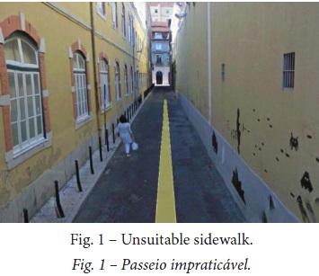
]]> 1.1. Formal PathwaysSidewalk: A sidewalk is often considered as a separate path, at a side from the road, usually paved and raised. Sidewalk morphological attributes vary amongst cities. The issue is if a sidewalk that is not raised, paved or at the side of the street is still a sidewalk, or, if a sidewalk that is practically unsuitable for people to walk can be still considered a sidewalk (fig. 1).
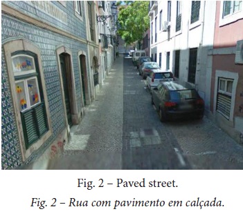
Paved streets: In these streets there is no physical separation of the sidewalk from the roadway. The separation between vehicle and pedestrian space occurs by means of differentiating the pavement colour or texture (fig. 2). Shared streets: Similar to the paved streets but have no specific spatial separation.
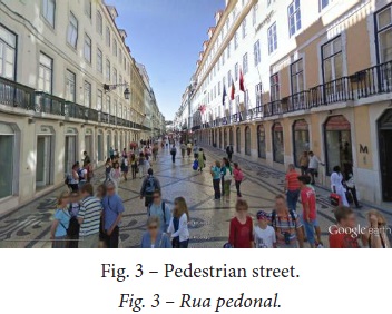
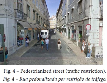
Pedestrianized streets: This type of street link is for exclusive pedestrian use and can be represented by a single sidewalk centreline (fig. 3). However we found cases where the street is a pedestrian street by means of regulatory traffic signals – no through traffic allowed – but not in terms of its configuration, maintaining segregated sidewalks from the roadway (fig. 4). In such cases we opt to adapt the representation to the actual walking behaviour, therefore using a single centreline link.
]]>
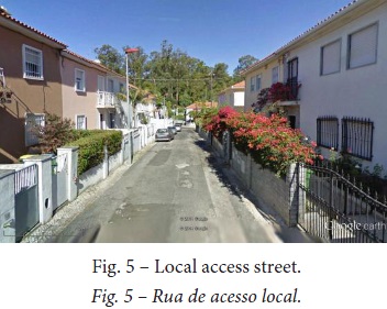
Local access streets: Following the same rationale as above, we have identified local access streets, where the traffic volume is very low and people tend to walk in the roadway albeit the presence of sidewalks or, more often, given the existence of impractical sidewalks (fig. 5).
Stairs and steps: Stair streets are common in the historical (older) neighbourhoods of cities like Lisbon, mainly in hilly environments and, albeit easing the access for most people, they are inaccessible for wheelchairs or baby strollers. Their identification is therefore crucial for accessibility analysis. However, while some sidewalks are fully composed of steps and are simple to classify, others only have steps on a small portion of its extent.
1.2. Formal crossings
The most common and easily identifiable crossing typologies are the formal crossings, such as zebra or pelican crossings and traffic light signalized crossings. Their representation can be relatively straightforward, whilst the representation of informal crossings requires further attention, as discussed later in the section.
Refuge islands: Refuge islands are portions of pavement that connect crossings. They can be used to provide a safe waiting area to cross road sections or to guide pedestrians to crossing areas.
Overpasses and underpasses: Often used to overcome a transportation infrastructure such as a railroad or a major road and often have stairs. In order to meet accessible design standards some overpasses and underpasses are composed of ramps or have escalators or lifts.
]]> 2. Detailed Network TypologiesThe “Detailed Network” comprises the representation of unmarked pathways and crossing features that are somehow overlooked in other pedestrian network digitization approaches.
2.1. Unmarked pathways
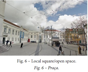
Squares and plazas: The representation of squares and plazas is challenging as they are in practical terms open spaces offering freedom of movement. On one hand their representation as polygons is unsuitable for network analysis and on the other hand defining only their boundaries by sidewalk links does not unveil all path possibilities. One way to overcome this issue is to delimit the square borders and set straight connections in between (fig. 6)
Parks and open spaces: In a similar way, we opt to represent parks and open spaces with their boundaries and a set of connectors between possible access points. Some parks do have formal paths and may require a more detailed representation.
2.2. Informal pedestrian crossings
Pedestrian crossings are critical to accessibility analysis and underline the necessity of using a pedestrian network instead of a centreline street network. The first issue deals with the formality of pedestrian crossings and its layout in the urban street network. When a pedestrian reaches the end of a sidewalk link usually continues the journey either by turning to the adjacent sidewalk thus contouring the block; by crossing straightway, carrying on the same direction or by crossing to the opposite side of the street. In order to minimize conflicts with other road users, pedestrian crossings are sometimes signalized by horizontal and/or vertical signs, that alerts car drivers and guides the pedestrian to a particular crossing location, that is to say to a formal crossing.
In most situations, crossing the street in the designated locations is convenient for the pedestrian, as it provides the necessary negotiation terms with other road users in order to reduce conflicts and to allow for a safe crossing. In other situations, the designated locations are not convenient for the pedestrian as they may imply a significant detour or waiting time, often resulting in jaywalking. Finally, there are cases where formal crossings simply do not exist in some urban contexts, either because such areas were developed prior to the existence of the automobile or because the existing traffic and pedestrian volumes do not justify the presence of a formal crossing.
]]> The representation of informal pedestrian crossings is therefore a challenge, namely for accessibility analysis, route planning and navigation. If informal crossing possibilities are not represented at all, we might be considering blocks as islands where pedestrians are stranded, namely in low traffic residential streets. On the other hand, if all informal crossing possibilities are represented we might be considering people (including children and seniors) can cross wide, heavy traffic streets where they are not meant to.In our case study we were able to observe various intersection configurations which were prone to different interpretations and representations, disclosing the need for setting digitization rules to produce uniform, realistic and parsimonious pedestrian crossing representations. Figure 7a represents the network formal crossings. Figure 7b illustrates the adopted rules for placing informal crossings.
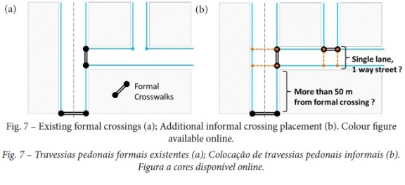
We suggest informal crossings to be placed at an intersection when in presence of single lane, one way streets, assuming relatively low traffic volume and speed, favouring a safe pedestrian crossing. Informal crossings are suggested to be placed at an intersection when in presence of two way streets and at a distance higher than 50m from a formal crossing (the Portuguese road regulations states that it is illegal for the pedestrian to cross the road if the nearest formal crossing is in a 50-meter vicinity). Informal crossings are not suitable features for streets that have three or more traffic lanes.
III. APPLICATION
In this section we describe the application of the digitization methodology to six cases with distinct urban characteristics in Lisbon, Portugal, highlighting the differences in the composition of the pedestrian network. The six cases are located in different districts and were selected in order to represent key variables of different urban planning and development stages or approaches. We looked for key urban development characteristics, for instance, development prior to the automobile advent vs. auto-centred city; formally planned vs. non-programmed development; incipient public space vs. abundant public space. In total, 223.8km of pedestrian network features were digitized using the proposed typology catalogue. The digitized pedestrian networks cover the following six districts (fig. 8):
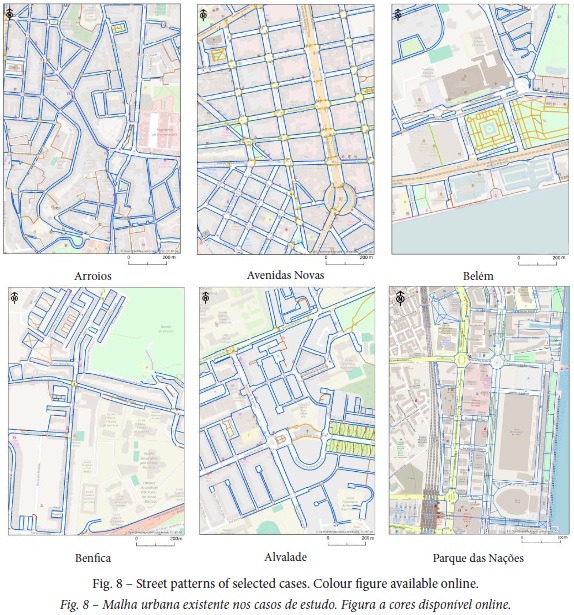
]]> Arroios: Located in central Lisbon, it is a mixed use area with predominant residential occupation formed by 4-6 story buildings. Its urban development began in the early 20th century, while major progresses occurred between 1919 and 1945. It is composed by a mix of regular and irregular street pattern of one to two lane road space. It is a hilly setup with a noticeable lack of open spaces and green areas. Digitized network length (DNL): 35.3km.
Avenidas Novas: Located also in central Lisbon, this district resulted from a planned urban intervention in the late 19th century. It is a mixed use area formed by medium rise buildings, today with a significant office occupation. The street design incorporated the French boulevard style, being characterized by a regular grid of large avenues with tree alignments in the medians. DNL: 61.5km.
Belém: Located by the Tagus River, it is a major historical and touristic landsite composed mainly by monuments, museums and parks. It has a substantial presence of pedestrian areas. DNL: 31.7km.
Benfica: This area resulted from a city expansion but in a rather unplanned manner. It is located close to the city boundaries and until mid-20th century this was mainly farmland. Real estate development was very intense between 1960 and 1990, led by private developers in response to a rapid population growth, namely due to migration from rural areas to Lisbon. As a result, the blocks are seldom regular and the buildings are not aligned. A great deal of open spaces is assigned to car parking. DNL: 19.9km.
Alvalade: This area resulted from a planned city expansion that took place in the mid-20th century (starting in 1945). It was designed in a so-called “neighbourhood-cell structure” , where all necessary facilities (schools, sports fields, green areas, markets, public services) were located within a walking distance from the households. Such structure allowed a coherent and centrifugal traffic assignment, where local access streets refrain through traffic benefiting pedestrian access and walking. There buildings are usually surrounded by green areas and are accessed by pedestrian pathways. DNL: 23.2km.
Parque das Nações: Located in the north-eastern part of Lisbon, by the Tagus River, this is a relatively recent urban expansion, established in the context the 1998 International Exhibition. It is a planned urban development incorporating the “Barcelona model” design features: ample public spaces and parks, high standard landscaping, pedestrian and bicycle recreational paths. DNL: 52.2km.
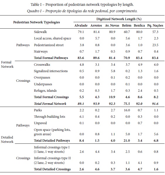
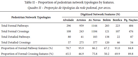
A summary of the extension of the digitized network typologies is presented in table I and table II. Table I shows the composition of the digitized pedestrian network, in terms of the relative length of the considered typologies. Standard sidewalks form the majority of the pedestrian network, representing from 60.7% to 79.1% of its length (M=73.2; SD=11.1). Concomitantly, approximately 20 to 40% of the pedestrian network in the studied cases is composed by other elements. Pedestrian crossings constitute an essential component of the network but their length is naturally shorter compared to pathway links, standing for 4.3% to 10.9% of the total formal network (M=7.0; SD=2.6). The latter is the case of Avenidas Novas, where urban fabric is laid by large avenues (4 to 8 traffic lanes).
 ]]>
]]>
The canonical pedestrian network, combining standard sidewalks and formal crossings, forms the bulk of the pedestrian network in all cases. This is particularly expressive in a regular grid pattern ( Avenidas Novas, 90.1%) and still very significant in less regular patterns (Alvalade, 84.3%; Arroios, 85.4% and Benfica, 86.2%). In the case of areas with ample public spaces, the share of standard sidewalks and formal crossings is noticeably lower (Belém, 64.4% and Parque das Nações, 64.9%). The formal pedestrian network, which comprises other discernible pathway and crossing types, represents more than 90% of the length of the walkable links in most studied cases. A lower proportion of formal links is found only in the case of Belém (75.5%), where people can walk through parks and open areas. The relevance of informal walkable links seems to be more related to the presence of certain features than to the sheer length of the informal network. This is the case of informal crossings. Informal crossings represent, in general, less than 5% of the network. However, in at least one area (Arroios) the number of informal crossings is higher than the number of formal crossings. This is due to the fact that most streets in this area have relatively low traffic volumes and, because their crossing does not pose a safety concern, the city’s traffic department does not consider necessary to formally represent the pedestrian crossings.
IV. Discussion and conclusions
We found two major differences in terms of the pedestrian network composition within a complex urban environment. One is related to the existence of public open spaces. The proportion of standard sidewalks tends to be higher than other typologies in areas with a lower offer of public space, whilst the pedestrian network of areas that have prominent public spaces encompasses other pathway typologies, namely pedestrian streets, plazas or paths in parks and gardens. The other is related to the inexistence of formal crossing. The proportion if non-marked, informal crossings, was found to be very relevant in most cases. The identification of pedestrian network links has required image interpretation which was not free of subjective judgement, especially in such areas. Setting up objective and uniform digitization guidelines was a critical step in order to assure a common level of detail to all cases.
We have identified a series of pathway typologies and analysed the composition of the pedestrian network within six distinct urban settings. We found that the canonical pedestrian network (sidewalks and formal crossings) formed up to 90% of the network of a regular grid street pattern but only up to 66% of the network of districts presenting a large proportion of open areas. While other pathways typologies may not be abundant in number or length they may be important links for pedestrian accessibility. Tal and Handy (2012) compared the network analysis capability of a standard street centreline network with a pedestrian network. They found that using a richer typological catalogue had an average increase of 12.2% in the area covered by a 5 minute walk (“pedshed”) around schools and retail centres. Moreover, realistic accessibility analysis and navigation applications require a correct representation of crossing opportunities. On one hand, considering the existence of crossings at each and single intersection may overestimate accessibility conditions. On the other hand, considering only formalized crossings may underestimate accessibility conditions. The correct representation of pedestrian crossings and different pathway typologies seem to require a level of interpretation that is still absent in semi-automated methods.
Semi-automated network generation methods have been tested successfully only in regular grid patterns, which is a very common pattern found in cities worldwide. Still, these methods require quality assurance and quality control. The time required for visual inspection, quality control and manual editing may compromise the effectiveness of such methods in complex urban setting. For instance (Li et al., 2018), reported an average time of manual editing of 1.3h/mi2 (0.5 h/km2).
Areas with less regular street patterns, areas with heterogeneous layout or areas with ample public spaces, which include parks and recreation areas that do not have a base feature in ancillary data, need to be constructed following other methodologies to obtain a realistic representation of the pedestrian environment. With time, we expect other digitization methods to be able to overcome the presented issues in order to produce reliable, cost-effective, pedestrian networks suitable for a large application range, although city-wide digitization would occur once with further developments thereon.
A future development could be related to the potential of VGI in the production and maintenance of large datasets. Currently, large amounts of pedestrian related data can be produced at virtually no cost, but the reliability of the data is not assured. Dedicated digital datasets that represent effectively the pedestrian space are crucial for the quality of accessibility and walkability analyses and in the development of pedestrian navigation services. As demonstrated in other studies (Neis & Zielstra, 2014; Mobasheri, Sun, Loos, & Ali, 2017) the application of OSM data for these purposes is still very limited. The harmonization of digitization procedures and raising awareness and engagement for pedestrian data collection could overcome present issues.
We found that, for the city of Lisbon, building a network enclosed by a 1km2 tile required, in average, 6 labour hours. This includes digitization as well as quality assurance and quality control. According to these figures it could be expected that the manual digitization of the whole city (100km2; 547 733 inhabitants) could be performed either by an individual in approximately 4 months or by a team of 4 people in approximately 1 month. We found these figures to be acceptable when considering the geometric and topological coherence and completeness of the digitized network, noting that the time estimation did not include the inclusion of additional feature attributes and that it can be completed as a whole, city-wide. Further urban developments will require corrections, like any other urban components.
This paper points out some representation issues found when manually digitizing distinct urban settings. A relevant issue is related to the variety of components that may be included in the network, ultimately relating to the necessary degree of detail required for certain applications. Another critical issue is related with the representation of pedestrian crossings. Albeit not very significant in terms of proportion, informal crossings are crucial to represent pedestrian behaviour correctly. Failing to represent them correctly may result in serious bias: for example, stranded pedestrians if informal crossings are not part of the network, unrealistic crossings if they are erroneously placed.
]]> Various approaches have been proposed as an alternative to the traditional, relatively time consuming and expensive method of manual digitization. Truth is all approaches have their significant issues, namely in terms of reliability. At this stage, manual digitization can produce more reliable and detailed networks, suitable for a broader application spectrum.
REFERENCES
Ballester, M. G., Pérez, M. R., & Stuiver, J. (2011). Automatic pedestrian network generation. [ Links ] Proceedings 14th AGILE International Conference on GIS, Association of Geographic Information Laboratories in Europe. Utrecht (The Netherlands).
Beale, L., Field, K., Briggs, D., Picton, P., & Matthews, H. (2006). Mapping for wheelchair users: Route navigation in urban spaces. The Cartographic Journal, 43(1), 68–81. doi: 10.1179/000870406X93517
Chin, G. K. W., Van Niel, K. P., Giles-Corti, B., & Knuiman, M. (2008). Accessibility and connectivity in physical activity studies: The impact of missing pedestrian data. Preventive Medicine , 46(1), 41–45.
Gaisbauer, C., & Frank, A. U. (2008). Wayfinding model for pedestrian navigation. [ Links ] 11th International Conference on Geographic Information Science. University of Girona, Girona, Spain
Goodchild, M. F. (2007). Citizens as sensors: The world of volunteered geography. GeoJournal, 69(4), 211–221. doi: 10.1007/s10708-007-9111-y
]]> Kang, B., Scully, J. Y., Stewart, O., Hurvitz, P. M., & Moudon, A. V. (2015). Split-Match-Aggregate (SMA) algorithm: integrating sidewalk data with transportation network data in GIS. International Journal of Geographical Information Science, 29(3), 440–453. doi: 10.1080/13658816.2014.981191Karimi, H. A. & Kasemsuppakorn, P. (2013). Pedestrian network map generation approaches and recommendation. International Journal of Geographical Information Science, 27(5), 947 –962. doi: 10.1080/13658816.2012.730148
Karimi, H. A., Zhang, L., & Benner, J. G. (2014). Personalized accessibility map (PAM): a novel assisted wayfinding approach for people with disabilities. Annals of GIS, 20(2), 99 –108. doi: 10.1080/19475683.2014.904438
Kasemsuppakorn, P., & Karimi, H. A. (2008). Data requirements and spatial database for personalized wheelchair navigation. [ Links ] 2nd International Convention on Rehabilitation Engineering & Assistive Technology. Singapore Therapeutic, Assistive & Rehabilitative Technologies (START) Centre.
Kwan, M. P., Murray, A. T., O’Kelly, M. E., & Tiefelsdorf, M. (2003). Recent advances in accessibility research: Representation, methodology and applications. Journal of Geographical Systems, 5(1), 129–138. doi: 10.1007/s101090300107
Li, H., Cebe, J., Khoeini, S., Xu, Y. A., Dyess, C., & Guensler, R. (2018). A Semi-Automated Method to Generate GIS-Based Sidewalk Networks for Asset Management and Pedestrian Accessibility Assessment. Transportation Research Record: Journal of the Transportation Research Board, 2672(44), 1-9. doi: 10.1177/0361198118757981 [ Links ]
Lundberg, B., Weber, J. (2014). Non-motorized transport and university populations: An analysis of connectivity and network perceptions. Journal of Transport Geography, 39, 165– 178. doi: 10.1016/j.jtrangeo.2014.07.002
Mobasheri, A., Sun, Y., Loos, L., & Ali, A. L. (2017). Are Crowdsourced Datasets Suitable for Specialized Routing Servicesâ¯? Case Study of OpenStreetMap for Routing of People with Limited Mobility. Sustainability, 9(997), 1–17. doi: 10.3390/su9060997
Moura, F., Cambra, P., & Gonçalves, A. B. (2017). Measuring walkability for distinct pedestrian groups with a participatory assessment method: A case study in Lisbon. Landscape and Urban Planning, 157, 282–298. doi: 10.1016/j.landurbplan.2016.07.002
]]> Neis, P., & Zielstra, D. (2014). Generation of a tailored routing network for disabled people based on collaboratively collected geodata. Applied Geography, 47(October 2013), 70 –77. doi: 10.1016/j.apgeog.2013.12.004OpenSidewalks (2016). OpenSidewalks project. Retrieved from http://opensidewalks.com/ [ Links ]
Parker, J. S., & Vanderslice, E. (2016). Pedestrian Network Analysis. Journal of Transport and Land Use, 9(3), 127–143.
Tal, G., & Handy, S. (2012). Measuring Nonmotorized Accessibility and Connectivity in a Robust Pedestrian Network. Transportation Research Record: Journal of the Transportation Research Board , 2299, 48–56. doi: 10.3141/2299-06
Recebido: janeiro 2019. Aceite: março 2019.
]]>