


 Inglês (pdf)
 Artigo em XML
 Referências do artigo
 Enviar este artigo por email
 Citado por SciELO
  Similares em
SciELO
Similares em
SciELO 
 Permalink
1. Introduction: the terraced landscape of the Cinque Terre
Terraced landscape is a characteristic feature throughout most of cultivated slopes in Italy and the whole Mediterranean area. It is a specific cultural landscape of great aesthetic, productive and environmental importance. Terraced terrain is considered to be the most emblematic and globally widespread kind of “anthropogenic terrain” (Stanchi et al., 2011) and one of the most evident and brilliant examples of man’s ingeniousness and drive to shape hostile territory to his needs. In Italy, the first traces of this historically relevant, historicized landscape date back to Neolithic times. According to Agnoletti and colleagues (2015), terraces started spreading throughout Italy in the Renaissance and became a defining element of our agricultural land. In the following centuries, demographic and socio-economic dynamics in the country led this particular kind of productive landscape to spread further, with a peak during the 1700s while the countryside was being repopulated and a renewed interest in the theories and techniques of agronomy regarding the transformation of mountainous and hill landscapes were taking place (Sereni, 1961).
Since the significant move of rural population to the cities in the '60s and '70s of the last century, terraced territory has been abandoned and its conditions have deteriorated. Cropping traditions and this productive landscape have suffered greatly from the development of mechanized agriculture, especially in those marginal and more impervious hill areas where cultivation is difficult. The effort and limited financial feasibility of building, maintaining and cultivating terraces without new agricultural machines has led, in some occasions, to the loss of traditional cropping practices and associated landscape typologies. As well as for their initial productive implications and the new kind of landscape they create, terraced systems have been studied and documented worldwide for their beneficial effects on hydrogeological stability of slopes and, consequently, of settlements. An important work of systematization of the existing scientific literature produced on this field of investigation has been done by Sofia and colleagues (2014), and Tarolli et al. (2014).
However, such methods of slope reinforcement and controlled runoff from rainwater fail to have these positive effects when they are managed according to short-term logic as opposed to following programs and long-term planning, or when maintenance is carried out with unsuitable techniques, thus enhancing the effects of superficial and runoff water with subsequent chain-reaction damage to vertical terrain elements, land saturation and landslide phenomena (Terranova et al., 2005). A common example of this in Italy is land losing its absorption and draining capacities due to dry-stone walls being built in non-traditional ways. These and other similar dynamics often have a catastrophic impact on vast areas of the landscape, as well as on the existing settlements and communities, which are in many cases listed heritage sites, already at risk because of other forms of weakness.
One of the most emblematic cases of this dynamic is surely that of the terraced vineyards in the Cinque Terre National Park, in Liguria, listed as “Parco dell’Uomo” (Park of Man) in 1999 with the goal of preserving its unique terraced anthropic landscape [1]. The national park of the Cinque Terre is the smallest and most densely populated in our country, with almost 100 inhab./km2 and a total area of 3.860 hectares. The municipalities of Monterosso, Vernazza with the hamlet of Corniglia, and Riomaggiore with the hamlet of Manarola developed along a 15-kilometer coastline. Steep slopes are the result of the specific morpho-lithological structure of the park where 75% of the land consists of sheer cliffs on the sea with angles of over 60°. These precipitous slopes have led, throughout the centuries, to a tightly-knit fabric of terraced strips of land built around two main features: the cultivated terraces and the dry-stone wall retaining elements, mostly built with in-situ sandstone and which have since 2018 been listed as world heritage. A grand landscape engineering design that is still today the supporting ground for crops, vineyards, stairways, cottages and trails. Vines, dry-stone walls and terraces stepping down to the sea have given this landscape that particular charm the poet Montale celebrated, greatly contributing to its picturesque, postcard-perfect image. And yet, the Cinque Terre are of growing media concern because the abandonment of these cultivated terraces has serious consequences for the hydrogeological balance of the area where the number of rockslides and landslides and the power and danger of floods are escalating.

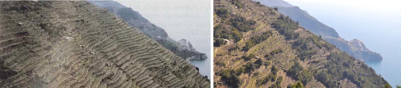
Source: photos and diagrams by the author (2018)
Fig. 1 The Cinque Terre National Park area and its steepnesses maintenance on new terraces in the national park area; a minor landslide over the SP370 road; renovation works on collapsed terraces after a heavy rainstorm above the village of Monterosso.
2. Challenges and issues
Such a terraced productive landscape, a “stepped topography” as defined by Sandor (1998), evidently requires constant care and also high energy consumption (Veek et al., 1995; Farina, 2000) especially to preserve, maintain and rebuild the terraces and dry-stone walls that are crumbling due to neglect (Londono, 2008). Data shows an alarming and significant decrease in the use of the cultivated terraces within the park: from 712 terraces in 1929 and about 260 at the beginning of the millennium (Terranova et al., 2006) today only 100 have crops. The key factors in this process can be traced back both to important socio-economic changes that this territory and its community have undergone in the last decades as well as to the difficulties arising from trying to adapt and mechanize cultivation in such an impervious environment, with a vastly fragmented land ownership. Tourism has increased exponentially and changed not only in numbers but also in type, especially since the Cinque Terre were selected as UNESCO world heritage as cultural landscape in 1997. Tourism has now put enormous pressure on the settlements and coastline and contributed to depopulating the inland areas, worsening the environmental fragile conditions.
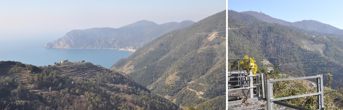
Source: cultivated terraces in the 1980s on the left (photo by R.Terranova, 1989: p. 17), and today's situation, on the right (photo by the author, 2019).
Fig. 2 Terraced vineyards in the Volastra area, between the villages of Corniglia and Manarola - the latter in the background comparison between the cultivated terraces in the 1980s and today's situation, on the right
However, the abandonment of the terraces and the operative and economic difficulties in preserving these landscaping systems are also the result of national and European policies regarding agriculture, forestry and the conservation of “natural” environments. Such policies have long welcomed reforestation processes also known as renaturalization (in Italy, about 75,000 ha of agricultural land are replaced by forest annually) instead of trying to preserve traditional crops, which at the wider scale represent an economically and productively less important element, and thus effectively banning the return to cultivated terraces if this is done through deforestation (Agnoletti, 2014). This approach however does not take into account the characteristics and local consequences of abandoning terraced land in the area, where ignoring the role these have in reducing hydrogeological risk is upsetting an already frail and failing equilibrium.
An assessment of the territory’s vulnerability highlights how the main threats to the Cinque Terre are the abandonment of the terraced landscape and its subsequent reforestation: in fact, the importance given to environmental over cultural values is exposing the terracing to serious threats, despite the fact that the preservation of natural systems is not itself the main cause for the decay of the cultural landscape (Agnoletti et al., 2015). In this sense, the concept of conservation and the efforts towards preserving the cultivated terraces today seem to have a merely aesthetic purpose, with the aim of freezing in time the picturesque image of the Cinque Terre that every year draws millions of visitors from all over the world. The programs, concessions and actions put in place in the area by many institutions are mainly for conservation uses, with the goal of resuming a landscaping system from a long-lost epoque and socio-economic organization which no longer exists (Dorato, Lobosco, 2020).
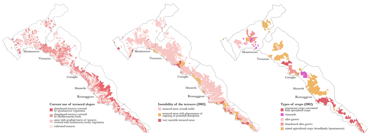
Source: photos by the author (2019).
Fig. 3 Vegetation reconquering the abandoned terraces from Vernazza to Punta Mesco, on the left; terraced slopes covered by spontaneous forests and close-up of a gear rack for grapes transportation in Volastra - Manarola, on the right
Terraces and their main features, the drainage system and its ability to stabilize slopes act necessarily in combination with agriculture: if the latter is absent then the terraces cannot provide their functional benefits, thus becoming not only purely aesthetic artifacts but also financially unsustainable. In contrast to the meaning of cultural landscape, an approach should be reconsidered which favors interdisciplinary and multi-scale methodologies that can work adopting new models and instruments towards a conscious and controlled development of the landscape, territory and settlements as well as a strengthened structural capacity in terms of resilience, which these places and communities would then be able to display. Today more than ever it is necessary to elaborate complex and preventive projects that operate through a collaborative and strategic long-term vision, as opposed to the current trend of dedicating resources and skills to mitigation and renovation interventions that only answer to temporary problems and events.
3. Methodology
The disciplinary contribution that urban, territorial and landscape design can bring to the table is twofold. On the one hand, as Fontanari (2008) mentions, it defines a more flexible and incisive regulatory framework to direct future transformations of terraced territories. In fact, as until now both local and higher-level policies have focused on regulations and guidelines for conservation (with prescriptive requirements in terms of preservation and maintenance of the terraced areas, and specific indications for materials and technologies to be used for the restoration of the elements), updating the normative framework would enable the identification of large portions of homogenous terraced land: the so-called “terracing units”. These units would be particularly effective in planning in the definition and spatial hierarchy of public funding aimed at restoring rural areas of heritage interest.
On the other hand, it would help to design and implement approaches and interventions that rely on the definition of future alternative landscape scenarios (Emanueli, Lobosco, 2018), which through the analysis of variable factors of uncertainty such as, for instance, climate change, the impact of tourism on the territory or the changes in planning regulation, can produce different visions for future territorial assets. Such selective approaches can support - depending on the different variables that have previously been identified - strategies and options (also short to medium-term) for future interventions on the cultivated terraces. Consequently, these choices have an effect on the management of hydrogeological risk: for instance, by giving urgent priority to stabilizing the more problematic areas such as the slopes around settlements (Dorato, 2019).
Some studies have already dealt with the issue and have developed GIS-topography methodologies to partition agricultural land in the Cinque Terre according to maintenance conditions on the terraces (Lombardi, Marchese, 2007). Tarolli and colleagues (2014) were able to display the potential of LIDAR technology in locating and mapping rockslide phenomena or structural damage to terraces beneath the forest layer; this kind of work is all the more necessary and relevant in the light of the definition given by Varotto and Ferrarese (2008) of terraced landscape as “diffused but cartographically invisible heritage”.
It is of upmost importance to define tools to support the strategic planning of authorities and create a management process built on different disciplinary contributions as well as a design vision for future developments of the Cinque Terre: scientific evidence and socio-economic aspects coming together within a coherent framework of landscape transformation. This need should, moreover, consider a certain degree of uncertainty due to anthropic and natural variable factors that can affect in the mid and long-term the definition of future scenarios. The resilience and efficacy of management and development policies for terraced landscapes are proportional to the ability to include such elements of uncertainty within the planning process and turn them into operative guidelines. In the context of this contribution, we will keep to the description of the main concepts around scenario planning methodologies (Wack, 1985; Di Giulio et al., 2018) applied to the Cinque Terre national park and highlight the possible side-effects on regulation and design.
The theoretical background behind planning through future scenarios consists, in this specific case, in considering the terraced landscape not as an ideal goal but rather as a means to manage territory in the light of concrete financial and political investment capacities that the area’s protection, maintenance and functioning will entail. In other words, the definition and comparative process of future alternative scenarios has the goal of choosing where and how to act on the terracing. This is carried out through a prioritized approach that takes into account the possibility that certain context-related conditions might through time undergo fluctuations or radical changes from the current and foreseen model of territorial development. In this sense, the expected result is homogenous areas for intervention - at a higher definition than those identified in the 2002 Park Plan, then revoked in 2010 - in which a series of actions such as selective abandonment, restoration, reuse, transformation and renovation of the terraces can be put to work. The aim is to efficiently reduce hydrogeological risk by optimizing resources, precision and adaptability for the type of intervention with regard to the main variable factors at play.
4. The application of the scenario planning: potential results and discussion
The predictive equation by Wischmeier and Smith (1958; 1978), also known as USLE Universal Soil Loss Equation, was used to choose and quantify the variable factors of uncertainty. It describes soil erosion (A) as a function of several factors:
A = R × K × L × S × C × P
where R stands for the rainfall erosivity factor; K the soil erodibility factor according to the geological composition of the terrain; L and S are respectively the length and angle of the slope, or the topographical component; C is the cropping management factor; and P the impact of direct or indirect cropping techniques to control erosion such as terraces, ploughing methods, retaining and partitioning techniques for agricultural land.
Each one of these parameters can be quantified, based on extensive scientific literature (Benavidez et al., 2018) to describe the local capacity of the slope to withstand erosion phenomena and to assess its development in time. By analyzing the equation, R and CxP are expected to be the factors of most uncertainty that will determine the context of each alternative scenario. R as a variable to predict climate development and CxP as a factor to estimate the applicability of adequate control and development policies for agriculture in the national park area.
Each one of these parameters has two peak values that generate the 2x2 matrix used to build up the scenarios [image 5]. R (variable 1) has peaks respectively in the maximum and minimum intensity of rainfall, as extrapolated from weather statistical models. The result are two maps of hydrogeological risk with different vulnerability indexes due to erosion. CxP (variable 2) is directly linked to the physical-infrastructural configuration of the territory and the assets of agricultural land. In the first case, the Park authorities would generally support terraced cultivation through incentives and grants; these areas would, subsequently, be located where accessibility is higher (closer to settlements and to main connections routes) and where the land ownership structure is less partitioned.
In the other case, the premise is that the same investment plan can be focused on selected areas, regardless of the size of the individual plots, with higher hydrogeological risk and less accentuated slopes, therefore with lower maintenance costs and higher agricultural profitability. The interaction of these two variables in the four different scenarios leads to four future territorial assets. From these figures and bearing the initial equation in mind, it is possible to assess from every “slope unit” [2] the quantities of potential soil loss due to erosion (A) as a function of set values of K, L and S. At this stage of the method it is possible to compare and superimpose the different scenarios in order to see which territorial settings present the highest risks and where the most invasive transformation measures, in terms of draining capacities and topographical features (K, L, S), could be applied to the terraced landscape. In this way, as previously mentioned, it is possible to classify individual “slope units” according to macro-categories, namely homogenous intervention areas with a hierarchical structure and different actions to be adopted and prioritized for realization.
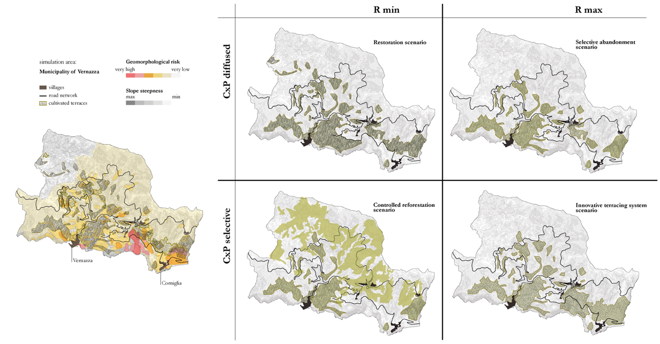
Source: author’s original work.
Fig.5 Application of the scenario planning methodology to the simulation area of the municipality of Vernazza: 2x2 matrix showing the possible four development scenarios for the terraced landscape in reference to one of the “slope units” of the Cinque Terre National Park.
The first typology of intervention is terrace restoration. This should be carried out through a historically coherent framework and traditional techniques in the areas with higher accessibility and in continuity with the terraced landscape still in use today (R min and CxP diffused). A second kind of intervention is that of the selective abandonment of the most remote or inaccessible terraced areas that are not within high hydrogeological risk areas (R max and CxP diffused). The third intervention is the reforestation process - with necessary demolition of the terrace and stabilization through greening of the slope - of the areas with highest landslide risk, where agriculture cannot be carried out according to the current parameters (R min and selective CxP). The fourth kind of intervention takes place in those areas with high hydrogeological risk where cultivation is still favorable and new terracing systems can be designed with different kinds of crops (for instance, reintroducing vines which have today largely been replaced by olive trees), different and more suitable morphologies for contemporary agricultural standards, new drainage systems and more efficient ground water refilling (R max and CxP diffused).
In strategic landscape planning terms, these actions will realistically need at least twenty years to develop. With this future horizon in mind, defining a resilient transformation program for the Cinque Terre National Park entails adapting to the different scenarios that might be generated in the near future. The reorganization of the territory on the basis of a new landscape asset cannot therefore occur without the development of a clear vision of one of the most impacting phenomena for the whole system: tourism. In this sense, the scenario planning could be further integrated with alternative restoration and reuse approaches for the terraces other than agricultural use. Above all, the possibility of developing tourism in the inner areas of the park, would take pressure off the coastline and redistribute touristic flows within the area.
In order to move in this direction, further effort and multi-sectorial thinking are needed to understand the current conditions and possible changes of other structural and characteristic elements of the area, such as: accessibility to the park and internal mobility (railway lines, sea connections, hiking trails, roads), tourism and policies designed to promote the territory. As most of the current management and programming system for future intervention is financially and environmentally unsustainable, it is necessary to develop a fresh disciplinary contribution able to foresee new and more resilient territorial configurations that can work collaboratively between the cultural and historical heritage conservation of this remarkable territory and ensure an efficient and controlled development of its landscapes.

